National Register of Historic Places listings in Owen County, Indiana
This is a list of the National Register of Historic Places listings in Owen County, Indiana.

This is intended to be a complete list of the properties and districts on the National Register of Historic Places in Owen County, Indiana, United States. Latitude and longitude coordinates are provided for many National Register properties and districts; these locations may be seen together in a map.[1]
There are 16 properties and districts listed on the National Register in the county. Another property was once listed but has been removed.
Properties and districts located in incorporated areas display the name of the municipality, while properties and districts in unincorporated areas display the name of their civil township. Properties and districts split between multiple jurisdictions display the names of all jurisdictions.
- This National Park Service list is complete through NPS recent listings posted June 19, 2020.[2]
Current listings
| [3] | Name on the Register[4] | Image | Date listed[5] | Location | City or town | Description |
|---|---|---|---|---|---|---|
| 1 | Allison-Robinson House |  Allison-Robinson House |
June 3, 1993 (#93000468) |
3 N. Montgomery St. 39°17′11″N 86°45′49″W |
Spencer | |
| 2 | David Enoch Beem House |  David Enoch Beem House |
July 13, 1989 (#89000771) |
635 W. Hillside Ave. 39°17′25″N 86°46′09″W |
Spencer | |
| 3 | Cataract Covered Bridge | 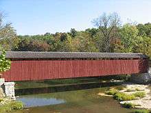 Cataract Covered Bridge |
April 27, 2005 (#05000339) |
Junction of County Roads 235W and 1000N over Mill Creek in the Leiber State Recreation Area at Cataract 39°26′00″N 86°48′48″W |
Jennings Township | |
| 4 | CCC Recreation Building-Nature Museum |  CCC Recreation Building-Nature Museum |
March 18, 1993 (#93000176) |
McCormick's Creek State Park, west of the junction of State Roads 43 and 46, and east of Spencer 39°17′30″N 86°43′38″W |
Washington Township | |
| 5 | Ennis Archaeological Site (12 OW 229) |  Ennis Archaeological Site (12 OW 229) |
May 30, 1985 (#85001167) |
Address Restricted |
Clay Township | Extends into Monroe County |
| 6 | Gosport Historic District |  Gosport Historic District |
June 25, 2013 (#13000425) |
Roughly bounded by Church, Walnut, 5th, and 3rd Sts. 39°20′57″N 86°39′48″W |
Gosport | |
| 7 | McCormick's Creek State Park Entrance and Gatehouse |  McCormick's Creek State Park Entrance and Gatehouse |
March 18, 1993 (#93000175) |
McCormick's Creek State Park, west of the junction of State Roads 43 and 46, and east of Spencer 39°17′02″N 86°43′34″W |
Washington Township | |
| 8 | Moffett-Ralston House | 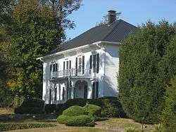 Moffett-Ralston House |
May 12, 1975 (#75000010) |
1.5 miles northeast of Patricksburg on Bixler Rd. 39°19′28″N 86°55′26″W |
Lafayette Township | |
| 9 | Dr. H.G. Osgood House |  Dr. H.G. Osgood House |
September 3, 1999 (#99001075) |
11 E. North St. 39°21′01″N 86°39′56″W |
Gosport | |
| 10 | Owen County Courthouse | 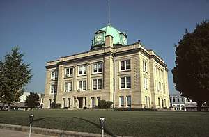 Owen County Courthouse |
November 25, 1994 (#94001351) |
Courthouse Square 39°17′08″N 86°45′43″W |
Spencer | |
| 11 | Secrest Ferry Bridge |  Secrest Ferry Bridge |
May 30, 1996 (#96000603) |
County Road 450E over the West Fork of the White River, south of Gosport 39°19′57″N 86°40′35″W |
Wayne Township | Extends into Monroe County |
| 12 | Secrest-Wampler House |  Secrest-Wampler House |
March 20, 2002 (#02000199) |
1816 Concord Rd., southwest of Gosport 39°18′59″N 86°42′06″W |
Washington Township | |
| 13 | Spencer Public Library |  Spencer Public Library |
September 20, 2007 (#07000980) |
110 E. Market St. 39°17′05″N 86°45′38″W |
Spencer | |
| 14 | Spencer Town Hall and Fire Station |  Spencer Town Hall and Fire Station |
August 19, 1982 (#82000027) |
84 S. Washington St. 39°17′07″N 86°45′40″W |
Spencer | Used as a law office (2005) |
| 15 | Stone Arch Bridge over McCormick's Creek | 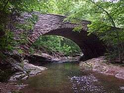 Stone Arch Bridge over McCormick's Creek |
March 18, 1993 (#93000177) |
McCormick's Creek State Park, west of the junction of State Roads 43 and 46, and east of Spencer 39°17′26″N 86°43′02″W |
Washington Township | |
| 16 | Vandalia Methodist Episcopal Church and Vandalia School |  Vandalia Methodist Episcopal Church and Vandalia School |
June 3, 2019 (#100004045) |
5434 and 5465 Vandalia Rd. 39°18′50″N 86°52′04″W |
Vandalia |
Former listing
| [3] | Name on the Register | Image | Date listed | Date removed | Location | City or town | Summary |
|---|---|---|---|---|---|---|---|
| 1 | New Albany and Salem Railroad Station | August 6, 1976 (#76000015) | October 13, 1983 | North St. at the White River 39°21′01″N 86°39′35″W |
Gosport |
See also
| Wikimedia Commons has media related to National Register of Historic Places in Owen County, Indiana. |
References
- The latitude and longitude information provided in this table was derived originally from the National Register Information System, which has been found to be fairly accurate for about 99% of listings. Some locations in this table may have been corrected to current GPS standards.
- "National Register of Historic Places: Weekly List Actions". National Park Service, United States Department of the Interior. Retrieved on June 19, 2020.
- Numbers represent an ordering by significant words. Various colorings, defined here, differentiate National Historic Landmarks and historic districts from other NRHP buildings, structures, sites or objects.
- "National Register Information System". National Register of Historic Places. National Park Service. March 13, 2009.
- The eight-digit number below each date is the number assigned to each location in the National Register Information System database, which can be viewed by clicking the number.
| Topics | |
|---|---|
| Lists by state |
|
| Lists by insular areas | |
| Lists by associated state | |
| Other areas | |
| Related | |
| |

Municipalities and communities of Owen County, Indiana, United States | ||
|---|---|---|
| Towns | Map of Indiana highlighting Owen County | |
| Townships | ||
| Unincorporated communities |
| |
| Ghost town | ||
| Footnotes | ‡This populated place also has portions in an adjacent county or counties | |