National Register of Historic Places listings in Jackson County, Indiana
This is a list of the National Register of Historic Places listings in Jackson County, Indiana.
This is intended to be a complete list of the properties and districts on the National Register of Historic Places in Jackson County, Indiana, United States. Latitude and longitude coordinates are provided for many National Register properties and districts; these locations may be seen together in a map.[1]
There are 18 properties and districts listed on the National Register in the county. Another property was once listed but has been removed.
Properties and districts located in incorporated areas display the name of the municipality, while properties and districts in unincorporated areas display the name of their civil township. Properties and districts split between multiple jurisdictions display the names of all jurisdictions.
- This National Park Service list is complete through NPS recent listings posted June 19, 2020.[2]
Current listings
| [3] | Name on the Register[4] | Image | Date listed[5] | Location | City or town | Description |
|---|---|---|---|---|---|---|
| 1 | Beatty-Trimpe Farm | 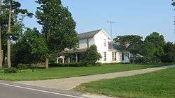 Beatty-Trimpe Farm |
March 26, 2003 (#03000138) |
4475 E. State Road 258, west of Seymour 38°58′24″N 85°57′00″W |
Hamilton Township | |
| 2 | Carr High School | 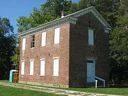 Carr High School |
December 15, 2011 (#11000910) |
10059 W. County Road 250 S., west of Medora 38°50′18″N 86°13′25″W |
Carr Township | |
| 3 | Cavanaugh Bridge |  Cavanaugh Bridge |
December 19, 2007 (#07001280) |
0.6 miles south of County Road 700S on County Road 550W over the Muscatatuck River, southwest of Brownstown 38°45′48″N 86°08′12″W |
Driftwood Township | Extends into Washington County |
| 4 | Farmers Club |  Farmers Club |
August 11, 1983 (#83000037) |
105 S. Chestnut St. 38°57′28″N 85°53′22″W |
Seymour | |
| 5 | First Presbyterian Church | 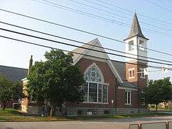 First Presbyterian Church |
December 19, 1991 (#91001867) |
301 N. Walnut St. 38°57′35″N 85°53′32″W |
Seymour | |
| 6 | Jackson County Courthouse |  Jackson County Courthouse |
December 15, 2011 (#11000911) |
111 S. Main St. 38°52′42″N 86°02′29″W |
Brownstown | |
| 7 | Joseph Jackson Hotel |  Joseph Jackson Hotel |
June 17, 2005 (#05000610) |
2420 S. Main St. in Vallonia 38°50′39″N 86°05′52″W |
Driftwood Township | |
| 8 | Low Spur Archeological Site (12J87) | 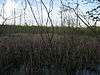 Low Spur Archeological Site (12J87) |
May 1, 1987 (#87000646) |
Address Restricted |
Jackson Township | |
| 9 | Medora Covered Bridge | 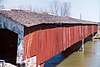 Medora Covered Bridge |
September 19, 2007 (#07000977) |
Off State Road 235, ½ mile southeast of Medora over the east fork of the White River 38°49′06″N 86°08′49″W |
Carr and Driftwood Townships | |
| 10 | T. Harlan and Helen Montgomery House |  T. Harlan and Helen Montgomery House |
December 27, 2010 (#10001080) |
628 N. Poplar St. 38°57′49″N 85°53′39″W |
Seymour | |
| 11 | Picnic Area-Jackson State Forest |  Picnic Area-Jackson State Forest |
January 2, 1997 (#96001554) |
Approximately 1 mile north of State Road 250 in the Jackson-Washington State Forest, southeast of Brownstown 38°52′00″N 85°59′58″W |
Driftwood Township | |
| 12 | Sand Hill Archeological Site 12J62 | 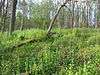 Sand Hill Archeological Site 12J62 |
September 7, 1982 (#82004914) |
Address Restricted |
Jackson Township | |
| 13 | Seymour Commercial Historic District | 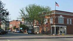 Seymour Commercial Historic District |
June 9, 1995 (#95000708) |
Roughly bounded by Walnut, 3rd, Ewing, and Bruce Sts. 38°57′28″N 85°53′21″W |
Seymour | |
| 14 | Shields' Mill Covered Bridge | .jpg) Shields' Mill Covered Bridge |
June 7, 2016 (#16000330) |
Shields Rd. across the East Fork of the White River 38°54′55″N 86°00′11″W |
Brownstown and Hamilton Townships | |
| 15 | Southern Indiana Railroad Freighthouse |  Southern Indiana Railroad Freighthouse |
June 22, 2003 (#03000541) |
105 N. Broadway 38°57′34″N 85°53′08″W |
Seymour | |
| 16 | George H. Vehslage House |  George H. Vehslage House |
September 23, 2010 (#10000775) |
515 N. Chestnut St. 38°57′45″N 85°53′32″W |
Seymour | |
| 17 | Walnut Street Historic District | March 6, 2020 (#100005044) |
Roughly bounded by North Chestnut, 7th and North Poplar Sts., but extending south on North Walnut St. to 3rd St. 38°57′49″N 85°53′36″W |
Seymour | ||
| 18 | Frank Wheeler Hotel |  Frank Wheeler Hotel |
August 9, 1991 (#91001161) |
Junction of 2nd and Main Sts. at Freetown 38°58′24″N 86°08′02″W |
Pershing Township |
Former listing
| [3] | Name on the Register | Image | Date listed | Date removed | Location | City or town | Summary |
|---|---|---|---|---|---|---|---|
| 1 | Bell Ford Post Patented Diagonal "Combination Bridge" | 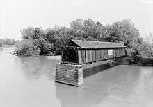 Bell Ford Post Patented Diagonal "Combination Bridge" |
March 25, 2005 (#05000194) | September 12, 2016 | State Road 258, 1.5 miles west of its junction with Community Dr., and northwest of Seymour 38°58′24″N 85°55′46″W |
Hamilton and Jackson Townships | Collapsed |
See also
| Wikimedia Commons has media related to National Register of Historic Places in Jackson County, Indiana. |
References
- The latitude and longitude information provided in this table was derived originally from the National Register Information System, which has been found to be fairly accurate for about 99% of listings. Some locations in this table may have been corrected to current GPS standards.
- "National Register of Historic Places: Weekly List Actions". National Park Service, United States Department of the Interior. Retrieved on June 19, 2020.
- Numbers represent an ordering by significant words. Various colorings, defined here, differentiate National Historic Landmarks and historic districts from other NRHP buildings, structures, sites or objects.
- "National Register Information System". National Register of Historic Places. National Park Service. March 13, 2009.
- The eight-digit number below each date is the number assigned to each location in the National Register Information System database, which can be viewed by clicking the number.
| Topics | |
|---|---|
| Lists by state |
|
| Lists by insular areas | |
| Lists by associated state | |
| Other areas | |
| Related | |
| |

Municipalities and communities of Jackson County, Indiana, United States | ||
|---|---|---|
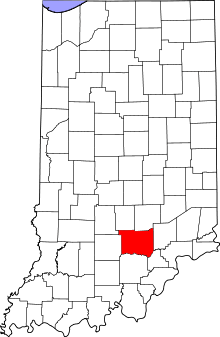
| City | Map of Indiana highlighting Jackson County | |
| Towns | ||
| Townships | ||
| CDPs | ||
| Other unincorporated communities | ||