National Register of Historic Places listings in Fayette County, Indiana
This is a list of the National Register of Historic Places listings in Fayette County, Indiana.

This is intended to be a complete list of the properties on the National Register of Historic Places in Fayette County, Indiana, United States. Latitude and longitude coordinates are provided for many National Register properties; these locations may be seen together in a map.[1]
There are 7 properties listed on the National Register in the county. Another property was once listed but has been removed.
Properties and districts located in incorporated areas display the name of the municipality, while properties and districts in unincorporated areas display the name of their civil township. Properties and districts split between multiple jurisdictions display the names of all jurisdictions.
- This National Park Service list is complete through NPS recent listings posted June 19, 2020.[2]
Current listings
| [3] | Name on the Register[4] | Image | Date listed[5] | Location | City or town | Description |
|---|---|---|---|---|---|---|
| 1 | Canal House | .jpg) Canal House |
July 16, 1973 (#73000016) |
111 E. 4th St. 39°38′24″N 85°08′22″W |
Connersville | |
| 2 | Connersville Downtown Historic District | .jpg) Connersville Downtown Historic District |
March 7, 2017 (#100000713) |
Roughly bounded by Eastern and Grand Aves. and E. and W. 4th and 9th Sts. 39°38′36″N 85°08′17″W |
Connersville | |
| 3 | Elmhurst | 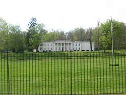 Elmhurst |
April 11, 1977 (#77000014) |
South of Connersville on State Road 121 39°37′53″N 85°08′45″W |
Connersville | |
| 4 | Fayette County Courthouse | .jpg) Fayette County Courthouse |
September 27, 2006 (#06000518) |
401 Central Ave. 39°38′27″N 85°08′26″W |
Connersville | |
| 5 | William Lowry House |  William Lowry House |
February 11, 1982 (#82000036) |
Kniese Rd., east of Bentonville 39°43′51″N 85°11′12″W |
Posey Township | |
| 6 | Thomas Ranck Round Barn | 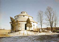 Thomas Ranck Round Barn |
January 11, 1983 (#83000030) |
North of Brownsville on County Road 500N 39°42′50″N 85°02′40″W |
Waterloo Township | |
| 7 | Roberts Park | 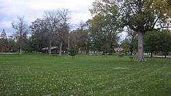 Roberts Park |
January 15, 2014 (#13001074) |
Park Rd. and 30th St. 39°40′12″N 85°07′30″W |
Connersville |
Former listing
| [3] | Name on the Register | Image | Date listed | Date removed | Location | City or town | Summary |
|---|---|---|---|---|---|---|---|
| 1 | Longwood Covered Bridge |  Longwood Covered Bridge |
December 29, 1981 (#81000011) | January 25, 1989 | Roberts Park |
Connersville |
See also
| Wikimedia Commons has media related to National Register of Historic Places in Fayette County, Indiana. |
References
- The latitude and longitude information provided in this table was derived originally from the National Register Information System, which has been found to be fairly accurate for about 99% of listings. Some locations in this table may have been corrected to current GPS standards.
- "National Register of Historic Places: Weekly List Actions". National Park Service, United States Department of the Interior. Retrieved on June 19, 2020.
- Numbers represent an ordering by significant words. Various colorings, defined here, differentiate National Historic Landmarks and historic districts from other NRHP buildings, structures, sites or objects.
- "National Register Information System". National Register of Historic Places. National Park Service. March 13, 2009.
- The eight-digit number below each date is the number assigned to each location in the National Register Information System database, which can be viewed by clicking the number.
| Topics | |
|---|---|
| Lists by state |
|
| Lists by insular areas | |
| Lists by associated state | |
| Other areas | |
| Related | |
| |

Municipalities and communities of Fayette County, Indiana, United States | ||
|---|---|---|
| City | Map of Indiana highlighting Fayette County | |
| Town | ||
| Townships | ||
| Unincorporated communities | ||
| Footnotes | ‡This populated place also has portions in an adjacent county or counties | |