National Register of Historic Places listings in Decatur County, Indiana
This is a list of the National Register of Historic Places listings in Decatur County, Indiana.
This is intended to be a complete list of the properties and districts on the National Register of Historic Places in Decatur County, Indiana, United States. Latitude and longitude coordinates are provided for many National Register properties and districts; these locations may be seen together in a map.[1]
There are 10 properties and districts listed on the National Register in the county.
Properties and districts located in incorporated areas display the name of the municipality, while properties and districts in unincorporated areas display the name of their civil township. Properties and districts split between multiple jurisdictions display the names of all jurisdictions.
- This National Park Service list is complete through NPS recent listings posted June 19, 2020.[2]
Current listings
| [3] | Name on the Register[4] | Image | Date listed[5] | Location | City or town | Description |
|---|---|---|---|---|---|---|
| 1 | Bromwell Wire Works | 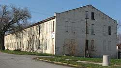 Bromwell Wire Works |
June 7, 1990 (#90000810) |
Junction of 1st and Ireland Sts. 39°20′39″N 85°29′22″W |
Greensburg | |
| 2 | Champ's Ford Bridge | 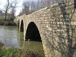 Champ's Ford Bridge |
December 22, 2009 (#09001127) |
County Road 100S over Clifty Creek, 2 miles west of Burney 39°19′12″N 85°40′33″W |
Clay Township | |
| 3 | Decatur County Courthouse | .jpg) Decatur County Courthouse |
April 27, 1973 (#73000014) |
Courthouse Square 39°20′13″N 85°29′01″W |
Greensburg | |
| 4 | Greensburg Carnegie Public Library | 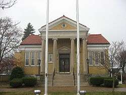 Greensburg Carnegie Public Library |
June 9, 1995 (#95000701) |
114 N. Michigan Ave. 39°20′23″N 85°29′09″W |
Greensburg | |
| 5 | Greensburg Downtown Historic District | .jpg) Greensburg Downtown Historic District |
September 14, 1995 (#95001113) |
Roughly the area surrounding the courthouse square 39°20′15″N 85°29′01″W |
Greensburg | |
| 6 | Bright B. Harris House | 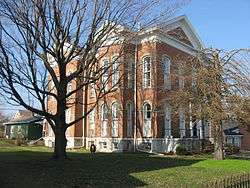 Bright B. Harris House |
December 28, 2000 (#00001545) |
413 N. Franklin St. 39°20′25″N 85°28′59″W |
Greensburg | |
| 7 | Jerman School | 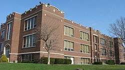 Jerman School |
September 15, 2005 (#05001017) |
316 W. Walnut St. 39°20′32″N 85°29′13″W |
Greensburg | |
| 8 | Knights of Pythias Building and Theatre | .jpg) Knights of Pythias Building and Theatre |
March 28, 1978 (#78000028) |
215 N. Broadway 39°20′17″N 85°29′05″W |
Greensburg | |
| 9 | Strauther Pleak Round Barn |  Strauther Pleak Round Barn |
June 24, 1993 (#93000557) |
Moscow Rd., 0.2 miles east of County Road 100W and north of Greensburg 39°22′28″N 85°30′01″W |
Washington Township | |
| 10 | Westport Covered Bridge | 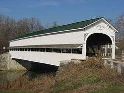 Westport Covered Bridge |
June 25, 1982 (#82000031) |
East of Westport 39°10′01″N 85°32′47″W |
Sand Creek Township |
See also
| Wikimedia Commons has media related to National Register of Historic Places in Decatur County, Indiana. |
References
- The latitude and longitude information provided in this table was derived originally from the National Register Information System, which has been found to be fairly accurate for about 99% of listings. Some locations in this table may have been corrected to current GPS standards.
- "National Register of Historic Places: Weekly List Actions". National Park Service, United States Department of the Interior. Retrieved on June 19, 2020.
- Numbers represent an ordering by significant words. Various colorings, defined here, differentiate National Historic Landmarks and historic districts from other NRHP buildings, structures, sites or objects.
- "National Register Information System". National Register of Historic Places. National Park Service. March 13, 2009.
- The eight-digit number below each date is the number assigned to each location in the National Register Information System database, which can be viewed by clicking the number.
| Topics | |
|---|---|
| Lists by state |
|
| Lists by insular areas | |
| Lists by associated state | |
| Other areas | |
| Related | |
| |

Municipalities and communities of Decatur County, Indiana, United States | ||
|---|---|---|
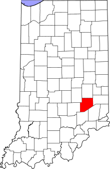
| City | Map of Indiana highlighting Decatur County | |
| Towns | ||
| Townships | ||
| CDPs | ||
| Other unincorporated communities |
| |
| Ghost town | ||
| Footnotes | ‡This populated place also has portions in an adjacent county or counties | |