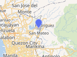
Rodriguez, Rizal
Rodriguez, officially the Municipality of Rodriguez (Tagalog: Bayan ng Rodriguez), formerly known as Montalban, is a 1st class municipality in the province of Rizal, Philippines. According to the 2015 census, it has a population of 369,222 people[5] making it as the most populous municipality in the country.
Rodriguez Montalban | |
|---|---|
| Municipality of Rodriguez | |
 Town Center (Poblacion) Area | |
 Seal | |
| Anthem: Rodriguez Hymn ("Mahal naming Rodriguez") | |
 Map of Rizal with Rodriguez highlighted | |
| |
.svg.png) Rodriguez Location within the Philippines | |
| Coordinates: 14°43′N 121°07′E | |
| Country | |
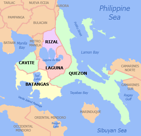
| Region | Calabarzon (Region IV-A) |
| Province | Rizal |
| District | 2nd District |
| Founded | 1909 |
| Renamed as Rodriguez | November 13, 1982[1] |
| Named for | Eulogio Rodriguez |
| Barangays | 11 (see Barangays) |
| Government | |
| • Type | Sangguniang Bayan |
| • Mayor | Dennis Hernandez[3] |
| • Vice Mayor | Anecito G. Lirazan[3] |
| • Congressman | Juan Fidel Felipe F. Nograles[3] |
| • Electorate | 209,134 voters (2019) |
| Area | |
| • Total | 312.70 km2 (120.73 sq mi) |
| Elevation | 27.1 m (88.9 ft) |
| Population (2015 census)[5] | |
| • Total | 369,222 |
| • Rank | 1 out of 1,489 Municipalities |
| • Density | 1,200/km2 (3,100/sq mi) |
| • Households | 13,854 |
| Economy | |
| • Income class | 1st municipal income class |
| • Poverty incidence | 4.52% (2015)[6] |
| • Revenue (₱) | 532,871,106.64 (2016) |
| Time zone | UTC+8 (PST) |
| ZIP code | 1860 |
| PSGC | |
| IDD : area code | +63 (0)2 |
| Climate type | tropical monsoon climate |
| Native languages | Sinauna language Tagalog |
| Major religions | Catholic Church, Evangelical Church, Iglesia ni Cristo |
| Feast date | October 7 |
| Catholic diocese | diocese of wilson regañon |
| Patron saint | Our Lady of the Most Holy Rosary |
| Website | www |
It is the northernmost town in the province and comes after San Mateo, Rizal, and Quezon City coming from Metro Manila. The town is located on the slopes of the Sierra Madre mountain range and features many resorts; it is the largest town in Rizal province with an area of 312.70 km². It contains the Montalban Gorge which is widely known as the location of the Legend of Bernardo Carpio. The gorge forms part of a protected area known as the Pamitinan Protected Landscape.
The municipality borders San Mateo, Rizal and Antipolo City, Rizal on the south, Norzagaray, Bulacan and San Jose Del Monte, Bulacan on the north, Quezon City on the west and General Nakar, Quezon on the east. It is one of the richest municipalities in the Philippines, ranking third in 2016 with an income of ₱ 691 million.[7]
Etymology
The town had received its former name of Montalban from a derivation of the Spanish word Monte (Mountain) from the numerous hills found within and surrounding the town.[8] A common name for the municipality up to the present, it was its official name from its founding in 1909 until 1982 when the Batasang Pambansa officially renamed it to Rodriguez under Batas Pambansa Blg.275 in honor of Eulogio Rodriguez, Sr., a native of the municipality who served as Senate President.[1]
History
Based on the 1954 journal History and Cultural Life of Montalban and its Barrios, what would then be the town of Montalban was formerly the barrio Balite which was under the jurisdiction of the town of San Mateo during the Spanish period. The town was then founded by Fr. Eustaquio of Pasig in 1871.[8] On another account, San Mateo, with its large size, was partitioned on April 27, 1871 when Captain General Rafael Izquierdo issued a decree separating the barrios of Balite, Burgos, Marang and Calipahan from San Mateo and formed them into the new municipality of Montalban.
According to the Executive Summary included in the Annual Audit Reports of Rodriguez, Rizal, the municipality of Montalban was founded on June 30, 1871 under the "Acta de Erreccion" or Deed of Foundation.[9] The municipality was then incorporated to the newly created Province of Rizal on June 11, 1901 by virtue of Philippine Commission Act No. 137.[10] Montalban was then consolidated with San Mateo by virtue of Philippine Commission Act No. 942 on October 12, 1903. San Mateo served as the seat of government in line with the economic centralization.[11] Montalban then became an independent municipality again by virtue of Executive Order No. 20 series of 1908 on February 29, 1908.
In 1982, the town was officially renamed to Rodriguez under Batas Pambansa Blg.275 in honor of the former Senate President and town native Eulogio Rodriguez, Sr.[1]
Proposed Cityhood
As early as 2018, the town's Sangguniang Bayan approved Resolution No. 60, Series of 2018 requesting the Senate of the Philippines thru its president, Vicente Sotto III and the House of Representatives through its speaker, Gloria Macapagal Arroyo to co-sponsor a bill for Rodriguez's conversion into a city.
Proposed Restoration of the Town Name to Montalban
On July 3, 2019, Rizal 2nd District Representative Juan Fidel Nograles has shared his plans on sponsoring a bill to restore the town's name to the former name of Montalban. This is a response to the numerous requests from the town's native residents to return the town's name to the former after it was changed in 1982.[12]
In fact, as of 2020, the municipal government, under Mayor Dennis Hernandez, has started to refer to the town as Montalban, while vice mayor Aniceto Lirazan considers it as Rodriguez.
Geography
Rodriguez is a town of mountains. From its north to south, a series of sloping ridges, hills and mountains ranges adorn the town. In fact, around 27% or the town is occupied by mountains and slopes. The town's highest peak is Mount Irid, 1,469 meters above sea level.
The province of Rizal covers 1,175.8 square kilometers. Rodriguez makes up 26.6% of the entire province of Rizal, housing 11 barangays. Rodriguez's economic activities include agriculture and commerce such as the Avilon Zoo.
Elevation and slope

The Municipality of Rodriguez is generally very rough in topography, with 83% of its total land area composed of upland areas, hills and mountain ranges. The remaining 17% low-lying terrain and rolling lands are found at the south-western portion of the municipality, along with the northern portions of the Municipality of San Mateo.
The rolling slopes comprise the Marikina River Valley, where water from higher elevations drain towards the Marikina River and its tributaries at the south-western portion of the municipality. Elevations at these western lowlands range from 10 to 30 meter above sea level. The western portion of the flatlands gently rises towards the west, which is part of Quezon City.
The mountainous regions of the Municipality of Rodriguez are found at the central and eastern areas, with sleepy sloping ridges and mountain ranges, traversing north to south. The terrain in these mountain ranges has slopes ranging from 30–50%. Very steep hills and mountains have slopes greater than 50%. Rolling to hilly areas 18–30% in slope can also be found. These high elevations are drained by the Tanay, Puray, and Rodriguez Rivers.
Barangays

Rodriguez is politically subdivided into 11 barangays (8 urban, 3 rural) [4] with the barangays of San Isidro and San Jose being two of the most populated barangays in the municipality and in the Philippines.[13]
| Barangay | Population (2015 census)[14] |
|---|---|
| Balite | 9,983 |
| Burgos | 44,100 |
| Geronimo | 5,554 |
| Macabud | 9,707 |
| Manggahan | 13,913 |
| Mascap | 4,699 |
| Puray | 3,921 |
| Rosario | 7,244 |
| San Isidro | 117,277 |
| San Jose | 124,868 |
| San Rafael | 27,956 |
| Rodriguez | 369,222 |
Climate
| Climate data for Rodriguez, Rizal | |||||||||||||
|---|---|---|---|---|---|---|---|---|---|---|---|---|---|
| Month | Jan | Feb | Mar | Apr | May | Jun | Jul | Aug | Sep | Oct | Nov | Dec | Year |
| Average high °C (°F) | 26 (79) |
27 (81) |
28 (82) |
31 (88) |
31 (88) |
30 (86) |
29 (84) |
29 (84) |
29 (84) |
29 (84) |
28 (82) |
27 (81) |
29 (84) |
| Average low °C (°F) | 22 (72) |
22 (72) |
22 (72) |
23 (73) |
25 (77) |
25 (77) |
25 (77) |
25 (77) |
24 (75) |
24 (75) |
23 (73) |
22 (72) |
24 (74) |
| Average precipitation mm (inches) | 40 (1.6) |
33 (1.3) |
35 (1.4) |
38 (1.5) |
138 (5.4) |
190 (7.5) |
242 (9.5) |
216 (8.5) |
224 (8.8) |
200 (7.9) |
114 (4.5) |
94 (3.7) |
1,564 (61.6) |
| Average rainy days | 12.2 | 9.0 | 11.0 | 11.7 | 21.5 | 24.0 | 27.2 | 26.1 | 26.8 | 22.3 | 16.3 | 15.1 | 223.2 |
| Source: Meteoblue [15] | |||||||||||||
Demographics

| Population census of Rodriguez | ||
|---|---|---|
| Year | Pop. | ±% p.a. |
| 1903 | 3,440 | — |
| 1918 | 5,201 | +2.79% |
| 1939 | 6,402 | +0.99% |
| 1948 | 5,257 | −2.17% |
| 1960 | 9,648 | +5.19% |
| 1970 | 20,882 | +8.02% |
| 1975 | 31,176 | +8.37% |
| 1980 | 41,859 | +6.07% |
| 1990 | 67,074 | +4.83% |
| 1995 | 79,668 | +3.28% |
| 2000 | 115,169 | +8.22% |
| 2007 | 223,594 | +9.58% |
| 2010 | 280,904 | +8.66% |
| 2015 | 369,222 | +5.34% |
| Source: Philippine Statistics Authority[5][16][17][18] | ||
In the 2015 census, the population of Rodriguez, Rizal, was 369,222 people,[5] with a density of 1,200 inhabitants per square kilometre or 3,100 inhabitants per square mile.
Transportation
The main transportation used in the municipality were jeepneys, tricycles, UVs, and buses. There are jeepneys that ply through the towns of San Mateo, Marikina and Cubao via Marcos Highway in Quezon City, some ply the route that leads to Philcoa in Quezon City via Batasan Road in San Mateo, others connect Rodriguez to Litex Road in Quezon City. The Marikina Auto Line Transport Corporation (MALTC) buses is the only one that regularly travels to farther places like Makati and Parañaque. UV's ply the routes to Cubao in Quezon City and Santa Lucia Grand Mall in Cainta.
Formerly there was railway service under the Philippine National Railways that traverses the San Mateo - Marikina - Pasig area and had its terminus at Barangay Balitè behind the Santo Rosario Parish Church but it had been long dismantled and the railway line converted into roadway that now consists of the road aptly named Daang Bakal.
It is known that 'patok' jeepneys originated from this town way back during the 80's. These jeepneys are known for their notoriety on the road. Despite this, they are popular among the passengers hence the name patók which means 'popular'. They still ply this town up to this day, most plying the Montalban-Cubao route via Marcos Highway. These jeepneys have already spread throughout the Rizal province as well as in Marikina City since then.
Municipal mayors
| No | Entered office | Exited office | Name |
|---|---|---|---|
| 1 | 1909 | 1916 | Eulogio Rodriguez |
| 2 | 1916 | 1919 | Eusebio Manuel |
| 3 | 1919 | 1928 | Gregorio Bautista |
| 4 | 1928 | 1932 | Jose Rodriguez |
| 5 | 1932 | 1936 | Roman Reyes |
| 6 | 1936 | 1940 | Jacinto Bautista |
| 7 | 1940 | 1942 | Francisco Rodriguez |
| 8 | 1942 | 1944 | Federico San Juan |
| 9 | 1944 | 1945 | Felix Salen |
| 10 | 1945 | 1945 | Gavino Cruz |
| 11 | 1945 | 1946 | Francisco Rodriguez |
| 12 | 1946 | 1947 | Catalino Bautista |
| 13 | 1947 | 1947 | Macario Bautista |
| 14 | 1947 | 1959 | Benigno Liamzon |
| 15 | 1960 | 1960 | Guillermo Cruz Sr. |
| 16 | 1960 | 1984 | Teodoro Rodriguez |
| 17 | 1984 | 1987 | Pablo Adriano |
| 18 | 1988 | 1993 | Angelito Manuel |
| 19 | 1993 | 1995 | Ernesto Villanueva |
| 20 | 1995 | 1998 | Pedro Cuerpo |
| 21 | 1998 | 2001 | Rafaelito San Diego |
| 22 | 2001 | 2010 | Pedro Cuerpo |
| 23 | 2010 | 2019 | Cecilio Hernandez |
| 24 | 2019 | Incumbent | Dennis Hernandez |
Hospitals
- H Vill Hospital
- N. Medcare Hospital
- St. Mark Hospital
- Montalban Infirmary
- Casimiro A. Ynares Sr. Memorial Hospital
Education
There are numerous elementary and high schools, both public and private, offering primary, secondary and tertiary education in the town of Rodriguez. There are also colleges and institutions that offer graduate and undergraduate programs in town.
Tourism
- Pamitinan Protected Landscape
- Wawa Dam[20]
- Puray Falls
- Rodriguez Ancestral Mansion
- Mount Pamitinan and Binacayan
- Mount Hapunang Banoi
- Mount Sipit-Ulang
- Avilon Zoo
Gallery
 Montalban Gorge (Pamitinan Protected Landscape)
 Wawa Dam
 Mount Mataba, one of the rolling hills in the Marikina Valley
 Rodriguez Municipal Gymnasium
 Nuestra Señora del Santísimo Rosario Parish Church
 Rodriguez Ancestral House
 Eulogio Rodriguez y Adona Historical Marker
 Licerio Geronimo Memorial
See also
- List of renamed cities and municipalities in the Philippines
- San Mateo, Rizal
References
- Batas Pambansa blg. 275 (November 12, 1982), An Act Changing the Name of the Municipality of Montalban, Province of Rizal, to the Municipality of Rodriguez, retrieved August 5, 2019
- "Municipality". Quezon City, Philippines: Department of the Interior and Local Government. Retrieved May 31, 2013.
- Dominguez-Cargullo, Dona (May 14, 2019). "Mga nagwaging kandidato sa Rodriguez, Rizal naiproklama na". Retrieved August 5, 2019.
- "Province: Rizal". PSGC Interactive. Quezon City, Philippines: Philippine Statistics Authority. Retrieved November 12, 2016.
- Census of Population (2015). "Region IV-A (Calabarzon)". Total Population by Province, City, Municipality and Barangay. PSA. Retrieved June 20, 2016.
- "PSA releases the 2015 Municipal and City Level Poverty Estimates". Quezon City, Philippines. Retrieved January 1, 2020.
- Commission On Audit's Annual Financial Report
- Torres, Ceferino; Mariano, Encarnacion; Cruz, Josefina; Bautista, Cecilia (1954). "History and Cultural Life of Montalban and its Barrios" (JPG, PDF). National Library of the Philippines Techno Aklatan. Manila, Philippines. National Library of the Philippines. p. 1. Retrieved March 7, 2019.
- Rodriguez, Rizal 2012 Annual Audit Report
- Act No. 137 (June 11, 1901), An Act extending the provisions of "the provincial government act" to the province of Rizal, retrieved August 5, 2019
- Act No. 942 (October 12, 1903), An Act reducing the thirty-two municipalities of the Province of Rizal to fifteen, retrieved August 5, 2019
- Roxas, Pathricia Ann (July 3, 2019). "Time for Rizal town of 'Montalban' to reclaim original name, says solon". Inquirer.net. Manila, Philippines. Philippine Daily Inquirer. Retrieved August 5, 2019.
- "Highlights of the Philippine Population 2015 Census of Population | Philippine Statistics Authority".
- "Philippine Statistics Authority's 2015 Census of Population". Philippine Statistics Authority.
- "Rodriguez: Average Temperatures and Rainfall". Meteoblue. Retrieved May 11, 2020.
- Census of Population and Housing (2010). "Region IV-A (Calabarzon)". Total Population by Province, City, Municipality and Barangay. NSO. Retrieved June 29, 2016.
- Censuses of Population (1903–2007). "Region IV-A (Calabarzon)". Table 1. Population Enumerated in Various Censuses by Province/Highly Urbanized City: 1903 to 2007. NSO.
- "Province of Rizal". Municipality Population Data. Local Water Utilities Administration Research Division. Retrieved December 17, 2016.
- Torres, Ceferino; Mariano, Encarnacion; Cruz, Josefina; Bautista, Cecilia (1954). "History and Cultural Life of Montalban and its Barrios" (JPG, PDF). National Library of the Philippines Techno Aklatan. Manila, Philippines. National Library of the Philippines. p. 3. Retrieved March 7, 2019.
- http://www.solitarywanderer.com/2012/04/caving-in-wawa-dam-montalban/ Caving in Wawa Dam, Montalban
External links
| Wikimedia Commons has media related to Rodriguez, Rizal. |
- Rodriguez Profile at PhilAtlas.com
- Philippine Standard Geographic Code
- Local Governance Performance Management System
- Caving in Wawa Dam, Montalban
Places adjacent to Rodriguez, Rizal | ||||||||||
|---|---|---|---|---|---|---|---|---|---|---|
| ||||||||||
| Authority control |
|---|