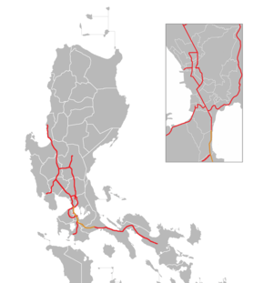
South Luzon Expressway
The South Luzon Expressway (SLE or SLEx), formerly known as the South Superhighway (SSH), Manila South Diversion Road (MSDR), and Manila South Expressway (MSEx), is a network of two expressways that connects Metro Manila to the provinces of the Calabarzon region in the Philippines. The first expressway is the Skyway, operated jointly by the Skyway Operation and Management Corporation (SomCo) and Citra Metro Manila Tollways Corporation (CMMTC). The second expressway, the South Luzon Tollway or Alabang–Calamba–Santo Tomas Expressway (ACTEx), is jointly operated by the South Luzon Tollway Corporation, a joint venture of the Philippine National Construction Corporation and the San Miguel Corporation-backed PT Citra Marga Nusaphala Persada Tbk group of Indonesia (the group where MTD Capital Berhad, the original partner, sold their shares) via the Manila Toll Expressway Systems, Inc. (MATES).
| |
|---|---|
| South Superhighway President Sergio Osmeña Sr. Highway[1] Dr. Jose P. Rizal Highway[2] | |
 | |
| Route information | |
| Part of AH26 | |
| Maintained by Department of Public Works and Highways and Metropolitan Manila Development Authority (Osmeña Highway/South Superhighway), Skyway Operations and Maintenance Corporation (Skyway At-Grade), and Manila Toll Expressway Systems, Inc. (South Luzon Tollway/SLEx Main/ACTEx) | |
| Length | 51 km (32 mi) |
| Existed | 1969–present |
| Component highways |
|
| Restrictions |
|
| Major junctions | |
| North end | |
| |
| South end | |
| Location | |
| Provinces | Metro Manila, Laguna, Cavite, Batangas |
| Major cities | Manila, Makati, Pasay, Taguig, Parañaque, Muntinlupa, San Pedro, Biñan, Santa Rosa, Cabuyao, Calamba, Santo Tomas |
| Towns | Carmona |
| Highway system | |
| |
.svg.png)
.svg.png)
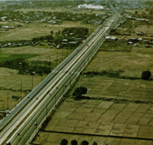
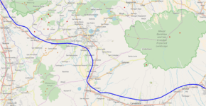
The expressway is a component of Expressway 2 (E2) of the Philippine expressway network and Radial Road 3 (R-3) of Manila's arterial road network. It starts in Manila's Paco district at Quirino Avenue and passes through the following cities and municipalities: Makati, Pasay, Parañaque, Taguig and Muntinlupa in Metro Manila, San Pedro and Biñan in Laguna, Carmona in Cavite, then transverses again to Biñan, Santa Rosa, Cabuyao and Calamba in Laguna, and ends at Santo Tomas in Batangas. The segment of the expressway from Magallanes Interchange to Calamba Exit (Exit 50) is part of Asian Highway 26 (AH26) of the Asian highway network.
In 2006, the South Luzon Tollway segment underwent rehabilitation through the SLEx Upgrading and Rehabilitation Project, which rehabilitates and expands the Alabang Viaduct as well as the road from Alabang to Calamba, and eventually connect the expressway to the Southern Tagalog Arterial Road in Santo Tomas, Batangas.
Route description
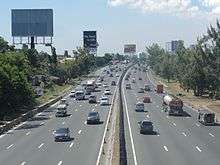
Since 2010, the South Luzon Expressway network cuts southwards from Manila up to the provinces of Laguna, Cavite, and Batangas. Future plans call for the extension of the expressway to Quezon. It is composed of the Metro Manila Skyway System and the South Luzon Tollway/Alabang-Calamba-Santo Tomas Expressway, which contains portions of the Pres. Sergio Osmeña Sr. Highway and Dr. Jose P. Rizal Highway. A short portion of the expressway between Magallanes and Nichols is built at-grade. Various high voltage overhead power lines, most notably the Paco-Muntinlupa segment of Sucat–Araneta–Balintawak and Bay–Biñan transmission lines of National Grid Corporation of the Philippines (NGCP) from Quirino Avenue to Maricaban Creek, Carmona to Calamba exits, and near Purok 2 Makiling overpass to Siam-Siam bridge, utilize a significant portion of the expressway route as the densely populated areas hinder acquisition of dedicated right of way.
Pres. Sergio Osmeña Sr. Highway/South Superhighway
| |
|---|---|
| Location | Manila – Makati |
The Pres. Sergio Osmeña Sr. Highway segment starts from an intersection at Quirino Avenue in Paco, Manila and goes straight to Alabang in Muntinlupa. The part of Osmeña Highway which passes through Manila, Makati, Pasay, and Taguig is toll-free; upon reaching the Nichols Toll Plaza the tolled expressway begins. Heading southward, the expressway has exits towards C-5 Road and Merville Subdivision, Parañaque in Pasay, Bicutan in Parañaque, and Sucat, Alabang, and Filinvest in Muntinlupa. This segment was formerly known as South Superhighway before Republic Act 6760 was passed, naming it after former President Sergio Osmeña.[1] Most of Osmeña Highway parallels the PNR Metro South Commuter Line.
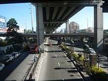
Osmeña Highway starts at the traffic light with Quirino Avenue. It then crosses San Andres Street, Ocampo (Vito Cruz) Street, and Zobel Roxas Street. The highway climbs over to pass above Gil Puyat Avenue through the Buendia Flyover, with service roads to serve that avenue and several side streets. The Skyway starts on the ramps past Buendia Flyover. Osmeña Highway crosses over Arnaiz Avenue, and soon crosses over EDSA at the Magallanes Interchange. The concurrency with the Pan-Philippine Highway starts at that interchange. Past Magallanes Interchange, the highway features 5 lanes, with 1 lane designated as motorcycle lanes until it comes near Nichols Interchange, where the toll road starts. Past the Sales Interchange, motorcycles below 400cc are prohibited from using the tolled expressway.
The part of Osmeña Highway north of Magallanes Interchange is maintained by the Department of Public Works and Highways (DPWH) through the South Manila District Engineering Office, and the portion south is maintained by the Skyway Operations and Management Company. The Metropolitan Manila Development Authority (MMDA) has jurisdiction also of both segments, and maintains motorcycle lanes up to Nichols.
Skyway At-Grade (Nichols–Alabang)
| |
|---|---|
| Location | Makati – Muntinlupa |
_sign.svg.png)
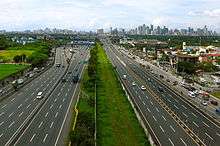
From Nichols, past the Sales Interchange, Osmeña Highway becomes the tolled at-grade Skyway. It includes service roads on either side up to Alabang. The expressway and its service roads run through the Pasay-Taguig boundary up to the C-5 Exit. Parallel to the highway, the PNR Metro South Commuter Line also runs between the at-grade and elevated Skyway segments until it passes the C-5 Exit. Past C-5, the two expressways follow the same alignment, one running above the other. They slightly curve and pass over Bicutan before running in a straight line, past the Sucat Exit and Dr. Santos Avenue, until they reach the Alabang Viaduct. The Osmeña Highway continues its straight line southward as it enters Muntinlupa, passing over barangays Sucat, Buli, and Cupang, before approaching Alabang, while the elevated Skyway curves westward and descends toward Alabang-Zapote Road. Alabang Exit was the terminus of the Osmeña Highway from 1969 to 1976, before the Alabang Viaduct was built and the expressway extended to Calamba. It is also the site of the former Alabang Toll Barrier prior to the split of the entire SLEX into two concessions, namely the Skyway System and SLTC-SLEX (formerly PNCC-SLEX). It climbs over the National Highway (National Road or officially Manila South Road) through the Alabang Viaduct, before it descends and becomes the Alabang-Calamba-Santo Tomas Expressway (ACTEx) or SLEX Main.
Dr. Jose P. Rizal Highway
From Kilometer 28.387 at San Pedro, Laguna southwards,[2] the Dr. Jose P. Rizal Highway segment runs through the province of Laguna, as well as a segment of Carmona at Cavite province before continuing back to Laguna from Biñan towards the exit at Calamba through the Maharlika Highway. The highway was also part of the Osmeña Highway until 1992, when R.A. 6760 was amended, which named the segment after the Philippine national hero and Laguna native, Dr. José Rizal.[2] The road starting from Alabang Viaduct in Muntinlupa up to Santo Tomas, Batangas forms the South Luzon Tollway, handled by the South Luzon Tollway Corporation, a joint venture of the Philippine National Construction Corporation and the SMC-backed Citra group of Indonesia.[3]
SLEX Main, Alabang-Calamba-Santo Tomas Expressway/South Luzon Tollway
| |
|---|---|
| Location | Muntinlupa – Santo Tomas, Batangas |
SLEX Main, South Luzon Tollway (SLT), or Alabang–Calamba–Sto. Tomas Expressway (ACTEX) are the alternate name for the part of the R-3 held by South Luzon Tollway Corporation. The ACTEx name refers to the segment of the two SLEX concessions from Alabang Exit in Muntinlupa up to Santo Tomas Exit in Santo Tomas, Batangas.
_-_Carmona_(Carmona%2C_Cavite%3B_2017-03-16).jpg)
SLEX Main/ACTEX starts past Filinvest Exit (Exit 23), with 2 to 4 lanes per direction and mostly paralleling the four-lane National Highway over Muntinlupa and northwestern Laguna.[4] The road slightly curves over barangays Bayanan and Putatan on Muntinlupa. The expressway's first service area, Tollway Plaza, having a Shell gas station, and several restaurants such as Jollibee, KFC, Greenwich, Burger King, among others, is also located at this segment. Past that service area, South Luzon Expressway mostly follows a straight course, passing the interchange serving Muntinlupa–Cavite Expressway, Susana Heights Subdivision, National Highway, and barangays Poblacion and Tunasan in Muntinlupa.
It soon enters Laguna at San Pedro, continuing as a straight roadway lined with billboards and passing through the city's residential and industrial areas before curving and ascending past the Petron and Caltex service areas to clear San Vicente Road, the disused spur of the PNR South Main Line towards General Mariano Alvarez, Cavite, and Pacita Avenue. South Luzon Expressway soon enters Biñan, passing near Southwoods City, Barangay San Francisco (Halang), and Splash Island, before entering Carmona, Cavite. It passes through Carmona in about one kilometer, with an exit to serve the town proper, before re-entering Biñan at Santo Tomas Bridge. The first route marker for AH26 is found at this segment. Returning to Binan, the road runs straight over Barangay Santo Tomas (Calabuso) and enters Barangay Mamplasan, with an exit to serve the Laguna International Industrial Park, several residential communities such as Brentville and Jubilation, and the new Cavite–Laguna Expressway. A Caltex service area is on the southbound lane past Mamplasan. It soon enters Santa Rosa, Laguna on a straight route, mostly lined with trees. It intersects Santa Rosa-Tagaytay Road to Santa Rosa city proper and Tagaytay through a partial cloverleaf interchange. South Luzon Expressway reduces into 3 lanes, having guard rails as the median divider. The road passes near Enchanted Kingdom and Eton City and is within the limits of barangays Pulong Santa Cruz and Malitlit. A Total service area lies on the northbound lanes of the expressway.
South Luzon Expressway enters Cabuyao, passing near Malayan Colleges Laguna (formerly the location of the warehouses owned by the defunct Uniwide Sales Inc.) and Santa Elena Golf and Country Club. It crosses the San Cristobal River and enters Calamba, going in a straight route until the Calamba Exit. South of the river, two Petron service stations could be found on opposite sides of the road. The road then approaches the Calamba toll plaza, widening to 18 lanes (including the lanes on the second southbound toll plaza and the northbound lanes), before returning to 3 lanes per direction. It passes through barangays Mayapa, Batino, and Prinza before approaching Calamba Exit. At Calamba Exit, AH26 leaves the expressway and follows again the Maharlika Highway. Calamba Exit is the former terminus of the South Luzon Expressway from 1976 to 2010. Calamba Exit was the former terminus of the South Luzon Expressway from 1976 to 2010, when the expressway was extended to connect with STAR Tollway and bypass the congested Maharlika Highway over Turbina.

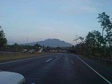
Past Calamba Exit, the expressway narrows to 2 lanes per direction, with no exits. South Luzon Expressway, also called the Alabang-Calamba-Santo Tomas Expressway, follows a curved route paralleling the Pan-Philippine Highway (Maharlika Highway) from Calamba to Santo Tomas, Batangas. It clears another disused spur of the PNR South Main Line towards Batangas City, approaches the Ayala Greenfield Estates toll plaza, continues over barangays Saimsim and Makiling, and then enters Batangas on Siam-siam Bridge. A few meters north of the Laguna–Batangas border is the location where the future Toll Road 4 will branch off. The expressway then curves and clears the same disused PNR spur to Batangas City before it ends at kilometer 57.2, continuing toward Batangas City as the STAR Tollway. However, the kilometer count of the next expressway after the Santo Tomas exit starts at kilometer 60.
History
South Luzon Expressway was originally built during the late 1960s as South Diversion Road or South Superhighway as newer roads used to travel from and to Manila.[5] South Superhighway was referred to as the Manila to Alabang segments that started in 1967 and was completed on December 16, 1969.
In 1976, the expressway was extended by another 29 kilometers (18 mi) from Alabang up to Calamba, Laguna. The project included the 850-meter (0.53 mi) long viaduct which crosses over Alabang and is called Alabang Viaduct. This later on became the boundary when the PNCC decided to split SLEX into two concessions which renamed the Nichols to Alabang segment as the South Metro Manila Skyway System while the Alabang to Santo Tomas segment retained the South Luzon Expressway concession branding.[6]
Rehabilitation and opening of connection with STAR Tollway
Prior to rehabilitation, the South Luzon Expressway was mostly an expressway with a grass median, and 2 lanes per direction from Alabang to Calamba. Rehabilitation work started in 2006, with heavy traffic brought by construction work. Alabang Viaduct was widened to 4 lanes per direction, and the construction of Skyway Stage 2 caused traffic disruptions on the Bicutan-Alabang segment (though mitigated by the use of the sosrobahu method to build and position the bridge piers). Rehabilitation work was finished in 2009, and the Alabang-Calamba segment was expanded to 3 to 4 lanes.
In 2010, an extension of the expressway, named Alabang-Calamba-Santo Tomas Expressway or ACTEx was opened, eventually connecting South Luzon Expressway to the STAR Tollway.
Future
Toll Road 4
| SLEx Toll Road 4 | |
|---|---|
| SLEx TR4 | |
 Proposed route of SLEX Toll Road 4 from Santo Tomas to Tayabas | |
| Route information | |
| Length | 66.74 km (41.47 mi) |
| Major junctions | |
| From | |
| |
| To | Lucena, Quezon |
| Location | |
| Major cities | Calamba, Santo Tomas, San Pablo, Tayabas, Lucena |
| Towns | Alaminos, Tiaong, Candelaria, Sariaya |

The SLEx Toll Road 4, also referred to as Toll Road 4 (or simply TR4) is a 66.74-kilometer (41.47 mi)[7] extension of South Luzon Expressway from Calamba (near its boundary with Santo Tomas, Batangas} to Lucena. Construction will be divided into five segments, with one additional extension to Mayao in Lucena on the revised project outline.[8][9] The extension project is implemented by the Toll Regulatory Board and will be operated by the South Luzon Tollway Corporation (SLTC). The extension would decongest the existing national road between Santo Tomas and Lucena, and provide a modern alternate route for travellers from Quezon to the Bicol Region. Right of way has been acquired for the first three segments between Santo Tomas and Tiaong, and ongoing for the remainder between Tiaong, Candelaria, and Tayabas. Right of way acquisition is ongoing as of 2019, and the groundbreaking ceremony was held on March 26, 2019, alongside the beginning of construction.[10] The future expressway will start near Ayala Greenfield toll plaza in Calamba rather than in Santo Tomas after various project alignment revisions due to right-of-way issues.
SLEx Extension to Sorsogon (Toll Road 5/Quezon–Bicol Expressway)
The SLEx Toll Road 5 or the Quezon–Bicol Expressway, will be the extension of South Luzon Expressway to Matnog, Sorsogon from Lucena. The total length of the extension would be 430 kilometers (270 mi). The extension hopes to decongest Andaya Highway and Pan-Philippine Highway, cut travel time from Manila to Naga by 2 to 3 hours, and to Matnog by 6 hours, and soon to be built by Manila Toll Expressway Systems Inc., a company partly owned (40%) by the Philippine National Construction Corporation, the rest shared equally by the local firm Alloy Manila Expressway Inc. and the SMC-backed Citra Group of Indonesia which bought the shares formerly owned by the MTD Capital Berhad of Malaysia. Since 2015, the extension has been discussed by then Albay Governor Joey Salceda, Toll Regulatory Board chairman Edmund Reyes, and San Miguel Corporation president Ramon Ang.[11]
Other future plans
Other planned expansion projects in the SMC-PNCC joint venture pipeline with connections to either SLEx and the Skyway system include:[12]
- the San Pedro–C6 Laguna Lake Road that will link SLEx from San Pedro, Laguna to C6 in Taguig;
- Skyway Stage 8 or Tanauan–Tagaytay Expressway, a 29-kilometer (18 mi) toll road;[13]
- Skyway Stage 7 that will connect Taguig to Commonwealth Avenue in Quezon City;
- Buendia Interchange and Ramp Extension to Macapagal Boulevard; and
- Skyway Stage 9 or Pasig River Alignment.
Technical specifications
- Name: South Luzon Expressway
- Concession Holder: Citra Metro Manila Tollways Corporation (Manila to Alabang), South Luzon Tollway Corporation (Alabang to Santo Tomas, Batangas)
- Operator: Skyway Operations and Maintenance Corporation (Manila to Alabang), Manila Toll Expressway Systems (Alabang to Santo Tomas, Batangas)
- Length: 60 kilometers (37 mi) (including the extension)
- Concession starting date: PNCC: March 1977, SLTC: August 2006
- Concession ending date: PNCC: March 2007, SLTC: March 2038
- Highway exits: 23
- Lanes: 6 Lanes (3 Lanes each direction) from Paco, Manila to Buendia, Makati. 12 Lanes (3 on both elevated and at-grade per direction) Buendia, Makati to Sucat, Muntinlupa, 10 Lanes (2 on the Elevated and 3 at-grade per direction) Sucat, Muntinlupa to Hillsborough, Muntinlupa. 8 Lanes (4 Lanes each direction) from Hillsborough, Muntinlupa to Santa Rosa, Laguna. 6 Lanes (3 Lanes each direction) from Santa Rosa, Laguna to Calamba, Laguna. 4 Lanes (2 lanes each direction) from Calamba Exit to Santo Tomas, Batangas.
- Toll plazas: 3
- Rest and Service Areas: 8
- Maximum Height Clearance on Underpasses: 4.27 meters (14.0 ft) (Nichols to Filinvest), 4.8 meters (16 ft) (Filinvest-Calamba), 5.1 meters (17 ft) (Calamba to end of expressway at Santo Tomas)
Toll
(2017-05-21).jpg)
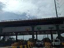
South Luzon Expressway employs closed and barrier toll systems. Upon entry on the expressway, drivers get a ticket with a printed QR code that is surrendered on the exiting toll plaza. The process was previously done using cards with a magnetic strip.
The expressway implements an electronic toll collection (ETC) system, the Autosweep RFID, using RFID technology, and the system formerly used "E-Pass", which uses transponder technology. The ETC system is shared by the Skyway, STAR Tollway, and NAIAX. ETC collection is done on dedicated lanes at the toll plaza, but also done on mixed toll lanes.
The toll rates by vehicle class are as follows:
| Class | Toll |
|---|---|
| Class 1 (Cars, Motorcycles, SUVs, Jeepneys) |
₱3.37/km |
| Class 2 (Buses, Light Trucks) |
₱6.74/km |
| Class 3 (Heavy Trucks) |
₱10.11/km |
Services
Service areas
The South Luzon Expressway has 8 service areas, with 4 on each direction. Most of the service areas occupy large land areas and have restaurants and retail space, with the exception of two service areas near Silangan Exit, which are simply Petron gas stations, both opened in 2016, with no other shops other than a San Mig Food Ave convenience store and car repair services. The service areas also provide ETC reloading for Autosweep RFID users.
| Location | Kilometer | Name | Services | Notes |
|---|---|---|---|---|
| Muntinlupa | 24 | Caltex SLEX Northbound | Demolished in 2006 after a larger service area in San Pedro opened. | |
| 25 | Shell SLEX Muntinlupa (Southbound) | BPI ATM, Burger King, Cinnabon, Hen Lin, Jollibee, KFC, Select, Shell, Starbucks, Army Navy, Max's (formerly Sumoutori), UCPB ATM, Pancake House, Red Ribbon and Starbucks Coffee | Southbound only. Originally called Tollway Plaza. | |
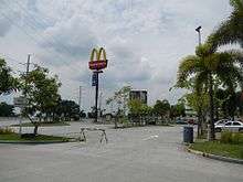
| San Pedro, Laguna | 28 | Petron SLEX San Pedro (Southbound) | Burger King, Chatime, Chowking, Jollibee, McDonald's, Petron, San Mig Food Ave, Starbucks, The Coffee Bean and Tea Leaf | Southbound only |
| Caltex SLEX San Pedro (Northbound) | Caltex, Cinnabon, Hen Lin, KFC, McDonald's, Pancake House, 7-Eleven (formerly Star Mart), Starbucks | Replaced Caltex service area in Muntinlupa on 2006. | ||
| Biñan | 35 | Shell SLEX Mamplasan (Northbound) | Army Navy, BPI ATM, Café France, Chowking, Fashion Rack Designer Outlet, Jollibee, Kenny Rogers Roasters, KFC, Levi's, Metrobank ATM, Macao Imperial Tea, Max's, Ministop, Nike Factory Outlet, North Park, Pizza Hut, Rai Rai Ken, Select, Shell, Sizzlin' Steak | Northbound only. Outlet stores added in 2016. |
| 37 | Caltex SLEX Mamplasan (Southbound) | Addy's Market, Army Navy, Brothers Burger, Caltex, Kenny Rogers Roasters, Km. 36 South Market, McDonald's, North Park, Seattle's Best Coffee, Shakey's, Sisa's Secret, Starbucks, Tokyo Tokyo, Yellow Cab Pizza | Southbound only. | |
| Santa Rosa, Laguna | 40 | Total SLEX Sta. Rosa (Northbound) | BPI ATM, Brothers Burger, Café Bonjour, Chowking, Jollibee, Krispy Kreme, Mang Inasal, Miniso, Tapa King, Total | Northbound only. |
| Calamba, Laguna | 44 | Petron KM 44 (Southbound) | Petron, San Mig Food Ave | Southbound only. Former Philippine National Construction Corporation field office. |
| Petron KM 44 (Northbound) | Petron, San Mig Food Ave | Northbound only. Former Philippine National Construction Corporation equipment storage. |
Lay-bys
The South Luzon Expressway also has lay-bys, or emergency parking areas where motorists can stop for safety checks on their vehicles and other emergencies.
Exits and intersections
Exits and intersections are numbered by kilometre post, with Rizal Park in Manila designated as kilometre 0. Exits are mostly named and numbered, but exit numbers appear only after Alabang Exit. There is a discrepancy with mileage, with Kilometer 24 being Kilometer 23 rather on the Manila Toll Expressway Systems (MATES) maintained segments of the expressway, although a Kilometer 23 already lies near Cupang, Muntinlupa. From Quirino Avenue to Magallanes Interchange, the expressway is an at-grade secondary national highway named Osmeña Highway, which is a component of National Route 145 (N145) of the Philippine highway network. No tolls are paid on Canlubang, Batino, and Calamba exits (exits 47, 49, and 50, respectively).
Osmeña Highway/South Superhighway
| Province | City/Municipality | km | mi | Destinations | Notes | |||
|---|---|---|---|---|---|---|---|---|
| Manila | 4.090 | 2.541 | Traffic light intersection. | |||||
| Skyway | Skyway-Quirino Exit. Northbound entrance only; partially opened. | |||||||
| 4.650 | 2.889 | San Andres Street | Traffic light intersection. No left turn allowed from either directions. | |||||
| 5.430 | 3.374 | Pablo Ocampo Street | Traffic light intersection. One-way street. | |||||
| 5.490 | 3.411 | Zobel Roxas Street | Traffic light intersection. One-way street. | |||||
| Makati | Skyway | Buendia Exit of Skyway Stage 3. Northbound exit and southbound entrance. The former was temporarily used as a northbound entrance prior to the partial opening of Stage 3's Buendia–Plaza Dilao segment.[14] | ||||||
| North end of Buendia Flyover | ||||||||
| Emilia Street / Malugay Street | Traffic light intersection. No entry to Osmeña Highway from Emilia Street. | |||||||
| Traffic light intersection. | ||||||||
| Finlandia Street / Dela Rosa Street | Traffic light intersection. No left turn allowed from northbound and no right turn allowed from southbound. | |||||||
| South end of Buendia Flyover | ||||||||
| 6.750 | 4.194 | Skyway | Skyway-Buendia Exit. Southbound exit and northbound entrance. | |||||
| 7.320 | 4.548 | Arnaiz Avenue | Traffic light intersection. No right turn allowed from northbound and no left turn from southbound. | |||||
| 7.800 | 4.847 | Don Bosco Street | Northbound access only. Southbound access via U-turn slot under Magallanes Interchange. | |||||
| 8.710 | 5.412 | Magallanes Interchange | ||||||
1.000 mi = 1.609 km; 1.000 km = 0.621 mi
| ||||||||
Expressway section
| Region | Province | City/Municipality | km | mi | Exit | Name | Destinations | Notes |
|---|---|---|---|---|---|---|---|---|
| Metro Manila | Makati | 7 | 4.3 | Magallanes Interchange. Start of AH26 overlap. | ||||
| Pasay – Taguig boundary | 8 | 5.0 | Skyway-Magallanes exit. Southbound exit and northbound entrance. | |||||
| Pasay | 9 | 5.6 | Sales Interchange. Serves Villamor Airbase, NAIA Terminal 3, and Newport City. | |||||
| North end of expressway restrictions | ||||||||
| Nichols toll plaza A (electronic toll collection, cash payments. Northbound only.) | ||||||||
| 11 | 6.8 | Merville | C-5 Road Extension – Merville | Southbound access only | ||||
| Nichols toll plaza B (electronic toll collection, cash payments. Southbound only.) | ||||||||
| 11 | 6.8 | C-5 | Northbound exit and southbound entrance | |||||
| Parañaque | 14 | 8.7 | Bicutan | Diamond interchange. | ||||
| 15 | 9.3 | Skyway | Northbound exit and southbound entrance. Demolished after the completion of Skyway Stage 2. | |||||
| Muntinlupa | 18 | 11 | Sucat | Diamond interchange. | ||||
| 20 | 12 | SLEX-Skyway exit. Northbound exit and southbound entrance. The ramps are referred to as Hillsborough by Skyway O&M Corporation (SOMCO), after the nearby Hillsborough Alabang Village, although there are no direction signs suggesting its name on both Skyway and SLEX. | ||||||
| 23 | 14 | South Station | Southbound exit only. Considered as part of Alabang Exit on the toll matrix. | |||||
| 23 | 14 | Alabang | Southbound exit and northbound entrance | |||||
| Manila South Expressway: Alabang toll plaza (1969–1976; demolished) | ||||||||
| North end of Alabang Viaduct | ||||||||
| 23 | 14 | Skyway | Northbound exit exclusively for Class 1 vehicles with RFID and southbound entrance.[15][16] Temporary 2-lane steel ramp built along the Alabang Viaduct.[17] | |||||
| 23 | 14 | Skyway | Future northbound exit. Future permanent on-ramp to be built on the shoulder of Alabang Viaduct.[18] | |||||
| South end of Alabang Viaduct | ||||||||
| 23 | 14 | 23 | Filinvest | Filinvest City | Trumpet interchange. South end of Skyway maintenance. North end of Manila Toll Expressway Systems maintenance. | |||
| 23 | 14 | Alabang | Northbound exit and southbound entrance. Toll booths of southbound access moved to dedicated booths from the southbound entrance booths of Filinvest Exit. | |||||
| 24 | 15 | Skyway | Apparently part of the Skyway-Susana Heights Exit despite being located approximately 2 kilometers (1.2 mi) north of SLEX-Susana Heights Exit. Future southbound entrance. Future southern terminus of Skyway Muntinlupa Extension.[18] | |||||
| 24 | 15 | Caltex (SLEX Northbound) service area (demolished) | ||||||
| 25 | 16 | Shell (SLEX Southbound) service area | ||||||
| 26 | 16 | Skyway | Apparent location of Skyway's Susana Heights on-ramp based on the ongoing construction works. Future northbound exit. Future southern terminus of Skyway Muntinlupa Extension.[18][19] | |||||
| 26 | 16 | 26 | MCX / Susana Heights | Hybrid T interchange and trumpet interchange | ||||
| Calabarzon | Laguna | San Pedro | 27 | 17 | 27 | San Pedro | San Pedro, La Marea | Southbound exit and entrance only. Future northbound access. |
| 29 | 18 | Petron (SLEX Southbound) service area | ||||||
| 29 | 18 | Caltex (SLEX Northbound) service area | ||||||
| Biñan | 32 | 20 | 31 | Southwoods | Southwoods City, Biñan | Partial cloverleaf or folded diamond interchange | ||
| Cavite | Carmona | 34 | 21 | 33 | Carmona | Trumpet interchange | ||
| Laguna | Biñan | 35 | 22 | Shell (SLEX Northbound) service area | ||||
| 36 | 22 | 36 | Greenfield City/Unilab (Mamplasan) | CALAX, Greenfield City, Unilab, LIIP, SRIT | Partial cloverleaf or folded diamond interchange. Exit leads to Mamplasan Roundabout towards CALAX. | |||
| 37 | 23 | Caltex (SLEX Southbound) service area | ||||||
| Santa Rosa | 38 | 24 | 38 | Sta. Rosa | Partial cloverleaf or folded diamond interchange | |||
| 40 | 25 | Total (SLEX) service area (northbound access only) | ||||||
| 41 | 25 | 41 | Eton City (Malitlit) | Eton City, ABI, Malitlit (Santa Rosa), Greenfield City, Tagaytay | Double right-in and right-out interchange | |||
| Cabuyao | 43 | 27 | 43 | Cabuyao | Pulo–Diezmo Road – Cabuyao, Sta. Elena City | Partial cloverleaf or folded diamond interchange. Serves Malayan Colleges Laguna. | ||
| Calamba | 44 | 27 | Petron Km. 44 SB (southbound access only) | |||||
| 44 | 27 | Petron Km. 44 NB (northbound access only) | ||||||
| 45 | 28 | 45 | Silangan | Silangan, Carmeltown, Mamatid | Partial cloverleaf or folded diamond interchange | |||
| 46 | 29 | Equus City | Right-in/right out exit. Still fenced. | |||||
| Calamba toll plaza A (electronic toll collection, cash payments) (Pass thru for Northbound vehicles) | ||||||||
| Calamba toll plaza B (Southbound only) (electronic toll collection, cash payments) | ||||||||
| 47 | 29 | 47 | Canlubang (Mayapa) | Mayapa–Canlubang Cadre Road – Canlubang, Mayapa | Partial cloverleaf or folded diamond interchange | |||
| 49 | 30 | 49 | Batino | Batino, Calamba Premier Industrial Park, Tagaytay Highlands | Southbound exit and entrance only. No toll payment from Canlubang exit. | |||
| 50 | 31 | 50 | Calamba | Half diamond interchange (north half) & partial cloverleaf or folded diamond interchange (south half). South end of AH26 overlap. Former southern terminus of SLEX from 1976 to 2010, prior to the opening of the Calamba–Santo Tomas extension. | ||||
| Ayala Greenfield Estates toll plaza (electronic toll collection, cash payments) | ||||||||
| SLEX Toll Road 4 | Connection with the future SLEX Toll Road 4. Interchange type not yet known. | |||||||
| Batangas | Santo Tomas | 57.2 | 35.5 | Sto. Tomas | Partial cloverleaf or folded diamond interchange. Access to National Shrine and Parish of St. Padre Pio. Continues south as | |||
1.000 mi = 1.609 km; 1.000 km = 0.621 mi
| ||||||||
Toll Road 4
| Province | City/Municipality | km | mi | Exit | Name | Destinations | Notes |
|---|---|---|---|---|---|---|---|
| Laguna | Calamba | 55 | 34 | Connection with the existing route of SLEx. Interchange type not yet known. | |||
| Batangas | Santo Tomas | 66 | 41 | Makban | Alaminos, Bay, Calauan | Diamond interchange.[20] This will also provide access to the MakBan Geothermal Plant. | |
| Laguna | Alaminos | No major junctions | |||||
| San Pablo | 77 | 48 | San Pablo | San Pablo | Trumpet interchange.[20] Connection to | ||
| Quezon | Tiaong | 85 | 53 | Tiaong | Directional T interchange.[20] This will be located north of Tiaong Bypass Road. | ||
| Candelaria | 100 | 62 | Candelaria | Candelaria, San Juan | Connection to | ||
| Candelaria Spur road toll plaza (electronic toll collection, cash payments) | |||||||
| Sariaya | No major junctions | ||||||
| Tayabas | 111 | 69 | Tayabas | Trumpet interchange.[20] | |||
| Lucena | Lucena | Lucena, Pagbilao | Future eastern terminus | ||||
1.000 mi = 1.609 km; 1.000 km = 0.621 mi
| |||||||
References
- "Republic Act No. 6760". Chan Robles Virtual Law Library. Retrieved March 1, 2009.
- "Republic Act No. 7620". Chan Robles Virtual Law Library. Retrieved March 1, 2009.
- "Archived copy". Archived from the original on April 3, 2009. Retrieved March 7, 2018.CS1 maint: archived copy as title (link) CS1 maint: BOT: original-url status unknown (link)
- Google (December 28, 2015). "South Luzon Expressway and Maharlika Highway/Manila South Road" (Map). Google Maps. Google. Retrieved December 28, 2015.
- Abecilla, Victor (November 3, 2015). "Practical solutions to Metro Manila". The Standard. Retrieved January 17, 2016.
- "Projects: SLEX". Philippine National Construction Corporation.
- Patinio, Ferdinand (March 28, 2019). "DPWH, SMC lead groundbreaking of SLEX Toll Road 4". Philippine News Agency. Retrieved June 14, 2020.
- Camus, Miguel R. (March 26, 2019). "SMC starts SLEx extension to Lucena". Business Inquirer. Retrieved June 14, 2020.
- "SLEX". Toll Regulatory Board. Retrieved June 14, 2020.
- "SOUTH LUZON EXPRESSWAY (SLEX) TOLL ROAD 4 (TR4)". Department of Public Works an Highways. Retrieved May 13, 2017.
- "I had long discussion with TRB Chairman... – Joey Constant Kindness Salceda". Facebook. May 8, 2015. Retrieved December 17, 2015.
- "San Miguel sets P554-billion toll road expansion – Krista A. M. Montealegre". BusinessWorld. April 27, 2017. Retrieved February 6, 2018.
- Dumlao-Abadilla, Doris (June 5, 2017). "P27-B Manila-Tagaytay toll road eyed". Inquirer Business. Retrieved June 13, 2020.
- Macaitan, Evelyn (July 21, 2018). "Skyway Stage 3 ramp opens in Makati City". The Philippine Star. Manila. Retrieved May 16, 2020.
- "Ramp, reopened lane ease SLEx traffic". Inquirer News. December 2, 2019. Retrieved May 27, 2020.
- Skyway Extension Project update as of June 2020. March 7, 2020. Retrieved June 9, 2020.
- "Temporary ramp at Alabang Viaduct going up Skyway now open". GMA News. December 1, 2019. Retrieved May 15, 2020.
- "WATCH: What will finished Skyway extension look like?". ABS-CBN News. Manila. October 13, 2019. Retrieved May 15, 2020.
- Skyway Extension Project update as of June 2020. June 9, 2020. Retrieved June 10, 2020.
- "Road and Bridge Inventory". www.dpwh.gov.ph. Retrieved June 14, 2020.
External links
| Wikimedia Commons has media related to South Luzon Expressway. |
| Operational | |
|---|---|
| Planned |
|
| Under construction |
|
See also: Philippine expressway network | |
| Expressways |
| ||||||
|---|---|---|---|---|---|---|---|
| National highways |
| ||||||
| Provincial roads and other major roads |
| ||||||
| Expressways |
| ||||||||
|---|---|---|---|---|---|---|---|---|---|
| National roads |
| ||||||||
| Arterial Routes |
| ||||||||
| Expressways |
| ||||||
|---|---|---|---|---|---|---|---|
| National highways |
| ||||||
| Expressways |
| ||||
|---|---|---|---|---|---|
| National roads |
| ||||