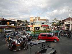
Balayan, Batangas
Balayan, officially the Municipality of Balayan (Tagalog: Bayan ng Balayan), is a 1st class municipality in the province of Batangas, Philippines. According to the 2015 census, it has a population of 90,699 people.[7]
Balayan | |
|---|---|
| Municipality of Balayan | |
 | |
Seal | |
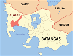 Map of Batangas with Balayan highlighted | |
OpenStreetMap 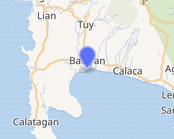
| |
.svg.png) Balayan Location within the Philippines | |
| Coordinates: 13°56′N 120°44′E | |
| Country | |
| Region | Calabarzon (Region IV-A) |
| Province | Batangas |
| District | 1st District |
| Founded | December 8, 1578 [1][2][3] |
| Barangays | 48 (see Barangays) |
| Government | |
| • Type | Sangguniang Bayan |
| • Mayor | Emmanuel Salvador P. Fronda II |
| • Mayor | Francisco S. Ramos |
| • Congressman | Elenita R. Ermita-Buhain |
| Area | |
| • Total | 108.73 km2 (41.98 sq mi) |
| Elevation | 23.0 m (75.5 ft) |
| Population (2015 census)[7] | |
| • Total | 90,699 |
| • Density | 830/km2 (2,200/sq mi) |
| • Households | 20,414 |
| Economy | |
| • Income class | 1st municipal income class |
| • Poverty incidence | 6.46% (2015)[8] |
| • Revenue (₱) | 200,500,213.79 (2016) |
| Time zone | UTC+8 (PST) |
| ZIP code | 4213 |
| PSGC | |
| IDD : area code | +63 (0)43 |
| Climate type | tropical monsoon climate |
| Native languages | Tagalog |
| Website | www |
The town is rich among the natural resources of sugarcanes, coconuts and corn. Significant events includes the Parada ng Lechon (every June 24) and the Feast of Immaculate Conception celebrated annually every December 8. Widely known products originating from the area include the Bagoong Balayan.
Etymology
Balayan is derived from the Old Tagalog word balayan, meaning "to walk past the paddy, from a basket to another"[9] and "carry or accomplish anything with the tip of any batten".[10] Other possible source is from the old Tagalog word balayang which means "wood".[9]
History
Tagalog literatures in Balayan were lost and destroyed at the coming of the Spaniards.[11] Jesuit Father Chirino testified they found (300) three hundred pre-colonial manuscripts in Balayan but to facilitate them the propagation of the Roman Catholic faith, early Jesuit missionaries destroyed the records.
Scholars and historians believed that Tagalog songs: Kumintang and Kundiman originated from Balayan.[12] Spanish writer and historian Wenceslao E. Retana recorded the lyrics of a popular Kundiman when he visited Batangas in 1888.[13]
Balayan has a close affinity to early history. The towns position on the basin of a good harbour was one of the reasons it became the first lands for local settlements in the Philippines, with existing records of local indigenous residents exchanging barter goods with Chinese traders dating back to the mid-14th century.
It was once the capital of a Moro Sultanate named Bon-bon whose area includes Mindoro to Cavite and even some parts of Metro Manila. The indigenous inhabitants of Balayan has close ties with the Brunei Sultanate of Maynilad under the leadership of Rajah Sulayman I and his uncle Rajah Matanda. There are historical accounts that Rajah Sulayman I stayed on this area when he tried to battle the Spaniards around Intramuros.[14]
Despite the presence of Spanish forces protected by the newly built stonefort in nearby Maynilad or Manila, Fort Santiago and Fort Intramuros Philippines, due to its natural harbor, a number of areas around the archipelago were often become launching grounds of counterattacks from the seafaring Moro people.
These events prompted local Spanish officials to set up a fort to prevent yearly Moro counterattacks.
Geography
Balayan is a lowland town in western Batangas. According to the Philippine Statistics Authority, the municipality has a land area of 108.73 square kilometres (41.98 sq mi) [5] constituting 3.49% of the 3,119.75-square-kilometre- (1,204.54 sq mi) total area of Batangas.
Balayan is bounded on the north by Tuy, west by Calatagan and Lian, east by Calaca, and south by the Balayan Bay.
Distance from Manila, the country’s capital, is about 107 kilometres (66 mi) and approximately 48 kilometres (30 mi) from Batangas City.
Topography
Balayan is strategically located at the center of western Batangas. The town is bounded on the north by Tuy, north-east by Nasugbu, east by Calaca, west by Lian, south-west by Calatagan, and south by Balayan Bay.
Climate
Balayan falls under the first type of climate: Dry season from November to April and Wet season from May to October. Balayan’s Atmospheric Temperature is 28.5 inches – 29.8 inches (English Mercurial Barometer Scale). The average annual temperature in Balayan is 27.2 °C (81.0 °F). The Average Annual Rainfall is 73.39 inches (1,864 mm).
| Climate data for Balayan, Batangas | |||||||||||||
|---|---|---|---|---|---|---|---|---|---|---|---|---|---|
| Month | Jan | Feb | Mar | Apr | May | Jun | Jul | Aug | Sep | Oct | Nov | Dec | Year |
| Average high °C (°F) | 29 (84) |
30 (86) |
31 (88) |
33 (91) |
32 (90) |
30 (86) |
29 (84) |
29 (84) |
29 (84) |
29 (84) |
29 (84) |
29 (84) |
30 (86) |
| Average low °C (°F) | 20 (68) |
20 (68) |
21 (70) |
22 (72) |
24 (75) |
24 (75) |
24 (75) |
24 (75) |
24 (75) |
23 (73) |
22 (72) |
21 (70) |
22 (72) |
| Average precipitation mm (inches) | 11 (0.4) |
13 (0.5) |
14 (0.6) |
32 (1.3) |
101 (4.0) |
142 (5.6) |
208 (8.2) |
187 (7.4) |
175 (6.9) |
131 (5.2) |
68 (2.7) |
39 (1.5) |
1,121 (44.3) |
| Average rainy days | 5.2 | 5.0 | 7.4 | 11.5 | 19.8 | 23.5 | 27.0 | 25.9 | 25.2 | 23.2 | 15.5 | 8.3 | 197.5 |
| Source: Meteoblue [15] | |||||||||||||
Barangays
Balayan is politically subdivided into 48 barangays.[16] The largest barangay in town is Patugo while the smallest is District 12.
| PSGC | Barangay | Population | ±% p.a. | |||
|---|---|---|---|---|---|---|
| 2015[7] | 2010[17] | |||||
| 041003001 | Baclaran | 2.8% | 2,505 | 2,220 | 2.33% | |
| 041003003 | Barangay 1 (Poblacion) | 2.4% | 2,194 | 1,938 | 2.39% | |
| 041003004 | Barangay 10 (Poblacion) | 3.5% | 3,184 | 2,845 | 2.17% | |
| 041003005 | Barangay 11 (Poblacion) | 1.5% | 1,332 | 1,321 | 0.16% | |
| 041003006 | Barangay 12 (Poblacion) | 0.4% | 363 | 300 | 3.70% | |
| 041003007 | Barangay 2 (Poblacion) | 1.2% | 1,119 | 1,394 | −4.10% | |
| 041003008 | Barangay 3 (Poblacion) | 1.4% | 1,269 | 1,185 | 1.31% | |
| 041003009 | Barangay 4 (Poblacion) | 2.2% | 1,982 | 1,851 | 1.31% | |
| 041003010 | Barangay 5 (Poblacion) | 2.1% | 1,871 | 1,758 | 1.19% | |
| 041003011 | Barangay 6 (Poblacion) | 1.1% | 1,027 | 998 | 0.55% | |
| 041003012 | Barangay 7 (Poblacion) | 0.4% | 402 | 339 | 3.30% | |
| 041003013 | Barangay 8 (Poblacion) | 2.6% | 2,365 | 2,130 | 2.01% | |
| 041003014 | Barangay 9 (Poblacion) | 1.7% | 1,511 | 1,446 | 0.84% | |
| 041003016 | Calan | 1.3% | 1,191 | 964 | 4.11% | |
| 041003017 | Caloocan | 6.7% | 6,113 | 4,888 | 4.35% | |
| 041003018 | Calzada | 2.0% | 1,793 | 1,416 | 4.60% | |
| 041003019 | Canda | 1.7% | 1,535 | 1,450 | 1.09% | |
| 041003020 | Carenahan | 1.2% | 1,105 | 1,030 | 1.35% | |
| 041003021 | Caybunga | 0.9% | 825 | 841 | −0.37% | |
| 041003022 | Cayponce | 1.6% | 1,482 | 1,388 | 1.26% | |
| 041003023 | Dalig | 3.3% | 3,012 | 3,008 | 0.03% | |
| 041003024 | Dao | 1.9% | 1,740 | 1,445 | 3.60% | |
| 041003025 | Dilao | 1.7% | 1,585 | 1,442 | 1.82% | |
| 041003026 | Duhatan | 1.7% | 1,579 | 1,518 | 0.75% | |
| 041003027 | Durungao | 1.1% | 954 | 937 | 0.34% | |
| 041003028 | Gimalas | 2.1% | 1,879 | 1,549 | 3.75% | |
| 041003029 | Gumamela | 3.1% | 2,781 | 2,595 | 1.33% | |
| 041003030 | Lagnas | 1.1% | 1,013 | 929 | 1.66% | |
| 041003031 | Lanatan | 3.2% | 2,901 | 2,715 | 1.27% | |
| 041003032 | Langgangan | 1.4% | 1,281 | 1,194 | 1.35% | |
| 041003033 | Lucban Putol | 1.6% | 1,428 | 1,383 | 0.61% | |
| 041003034 | Lucban Pook | 1.8% | 1,658 | 1,551 | 1.28% | |
| 041003035 | Magabe | 2.0% | 1,832 | 1,779 | 0.56% | |
| 041003036 | Malalay | 1.4% | 1,274 | 1,063 | 3.51% | |
| 041003037 | Munting Tubig | 1.8% | 1,619 | 1,534 | 1.03% | |
| 041003038 | Navotas | 4.4% | 3,961 | 3,451 | 2.66% | |
| 041003039 | Patugo | 2.8% | 2,532 | 1,885 | 5.78% | |
| 041003040 | Palikpikan | 1.4% | 1,280 | 1,150 | 2.06% | |
| 041003042 | Pooc | 2.8% | 2,545 | 2,267 | 2.23% | |
| 041003043 | Sambat | 2.8% | 2,544 | 2,345 | 1.56% | |
| 041003044 | Sampaga | 3.1% | 2,785 | 2,386 | 2.99% | |
| 041003045 | San Juan | 2.2% | 1,958 | 1,738 | 2.30% | |
| 041003046 | San Piro | 4.1% | 3,703 | 3,377 | 1.77% | |
| 041003048 | Santol | 2.9% | 2,612 | 2,385 | 1.75% | |
| 041003049 | Sukol | 1.0% | 947 | 837 | 2.38% | |
| 041003050 | Tactac | 1.1% | 986 | 932 | 1.08% | |
| 041003051 | Taludtud | 1.4% | 1,255 | 1,165 | 1.43% | |
| 041003052 | Tanggoy | 2.1% | 1,887 | 1,543 | 3.91% | |
| Total | 90,699 | 81,805 | 1.98% | |||
Demographics
| Population census of Balayan | |||||||||||||||||||||||||||||||||||||||||||||||||
|---|---|---|---|---|---|---|---|---|---|---|---|---|---|---|---|---|---|---|---|---|---|---|---|---|---|---|---|---|---|---|---|---|---|---|---|---|---|---|---|---|---|---|---|---|---|---|---|---|---|
|
| ||||||||||||||||||||||||||||||||||||||||||||||||
| Source: Philippine Statistics Authority[7][17][18][19] | |||||||||||||||||||||||||||||||||||||||||||||||||
In the 2015 census, Balayan had a population of 90,699.[7] The population density was 830 inhabitants per square kilometre (2,100/sq mi).
The main language used by the people in Balayan is Tagalog but some can still speak and understand basic Spanish. Literate people can speak English but it is often used in formal occasions or events only.
Religion
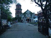
Churches:
- Immaculate Conception Parish Church (Balayan)
- Ermita Church
- Jesus the Peace Maker Christian Church
- Jesus Is Lord Church
Economy
- Phil Steel Corporation (Steelcorp) – manufacturer of coated steel sheets, coils and irons
- Batangas Sugar Cane Central – the mother company of Muscuvado Food Sugar Corp. and processes sugar cane
- ProGreen Distillery (Emperador)
Government
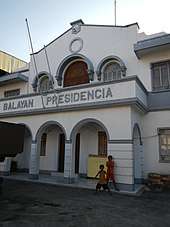
Incumbent officials
- Mayor – Emmanuel Salvador "JR" Fronda
- Vice Mayor – Cocoy Ramos
- Councilors:
- Jhun Santos
- Raymund De La Vega
- Joebert Mapalad
- Carlos Ermita Alvarez
- Elmer Del Carmen
- Marlon Martinez
- Benjamin X Garcia-Ascue
- Bernardo Pantoja
Tourism
Balayan BayWalk Park – On January 2009, Balayan renovated a mini park which will provide locals and tourists a view of Balayan Bay similar to what is seen in the country’s capital.
Health
Hospitals in Balayan include:
- Medical Center Western Batangas
- Balayan Bayview Hospital and Medical Center
- Don Manuel Lopez Memorial District Hospital
- Metro Balayan Medical Center
Education
Balayan has several schools, institutions and university both public and private located within and outside the Poblacion.
Public schools include:
- Balayan East Central School
- Balayan West Central School
- Balayan National High School
- Batangas State University – Balayan Campus
Private schools include:
- Immaculate Conception College
- Blessed Christ Child Montessori Foundation
- Balayan Colleges
- Balayan Kiddie Learning Center
- Our Lady of Miracles Learning Center
- STI College – Balayan
- Kim Harold Computer and Technical School (Fraternidad St.)
- Core Science Academy
- Saint Paul College Balayan
- Schola Nazaria Inc.
Notable people
- Sixto C. López – propagandist and negotiator for Philippine independence from the United States
References
- https://aboutphilippines.ph/files/A-BRIEF-HISTORY-OF-BALAYAN.pdf&ved=2ahUKEwjdqfebz-DbAhVHU30KHUm0BtQQFjASegQIBRAB&usg=AOvVaw1l3XhMgQI6E8Jk9jilZLyO
- https://m.facebook.com/story.php?story_fbid=1384400818267698&id=171685902872535
- http://stampdata.com/stamps.php?fdenomraw=8756&fissuer=632
- "Municipality". Quezon City, Philippines: Department of the Interior and Local Government. Retrieved 31 May 2013.
- "Province: Batangas". PSGC Interactive. Quezon City, Philippines: Philippine Statistics Authority. Retrieved 12 November 2016.
- "Balayan, Batangas Profile". PhilAtlas.com. Retrieved 15 June 2020.
- Census of Population (2015). "Region IV-A (Calabarzon)". Total Population by Province, City, Municipality and Barangay. PSA. Retrieved 20 June 2016.
- "PSA releases the 2015 Municipal and City Level Poverty Estimates". Quezon City, Philippines. Retrieved 1 January 2020.
- Juan José de Noceda and Pedro de Sanlúcar, Vocabulario de la Lengua Tagala, (Manila: Imprenta de Ramírez y Giraudier, 1860), 30.
- de Noceda and de Sanlúcar, 369.
- Eufronio Melo Alip, Tagalog literature: a historico-critical study, p. 20.
- Eufronio Melo Alip, Tagalog literature: a historico-critical study, p. 18.
- Wenceslao Emilio, El Indio Batangueño: (estudio etnográfico), p. 25.
- Blair and Robertson
- "Balayan: Average Temperatures and Rainfall". Meteoblue. Retrieved 5 May 2020.
- "Municipal: Balayan, Batangas". PSGC Interactive. Quezon City, Philippines: Philippine Statistics Authority. Retrieved 8 January 2016.
- Census of Population and Housing (2010). "Region IV-A (Calabarzon)". Total Population by Province, City, Municipality and Barangay. NSO. Retrieved 29 June 2016.
- Censuses of Population (1903–2007). "Region IV-A (Calabarzon)". Table 1. Population Enumerated in Various Censuses by Province/Highly Urbanized City: 1903 to 2007. NSO.
- "Province of Batangas". Municipality Population Data. Local Water Utilities Administration Research Division. Retrieved 17 December 2016.
External links
| Wikimedia Commons has media related to Balayan, Batangas. |
| Wikisource has the text of the 1911 Encyclopædia Britannica article Balayan. |
Places adjacent to Balayan, Batangas | ||||||||||
|---|---|---|---|---|---|---|---|---|---|---|
| ||||||||||
Batangas (capital) | |
| Municipalities | |
| Component cities | |