Mabitac, Laguna
Mabitac, officially the Municipality of Mabitac, (Tagalog: Bayan ng Mabitac), is a 5th class municipality in the province of Laguna, Philippines. According to the 2015 census, it has a population of 20,530 people.[3]
Mabitac | |
|---|---|
| Municipality of Mabitac | |
 Hilltop view of Mabitac | |
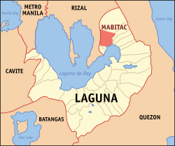 Map of Laguna with Mabitac highlighted | |

| |
.svg.png) Mabitac Location within the Philippines | |
| Coordinates: 14°26′N 121°25′E | |
| Country | |
| Region | Calabarzon (Region IV-A) |
| Province | Laguna |
| District | 4th District |
| Founded | January 6, 1616 |
| Barangays | 15 (see Barangays) |
| Government | |
| • Type | Sangguniang Bayan |
| • Mayor | Ronald I. Sana |
| • Vice Mayor | Angelito V. Valderrama Sr. |
| • Congressman | Benjamin C. Agarao Jr. |
| • Electorate | 14,602 voters (2019) |
| Area | |
| • Total | 80.76 km2 (31.18 sq mi) |
| Elevation | 5.2 m (17.1 ft) |
| Population (2015 census)[3] | |
| • Total | 20,530 |
| • Density | 250/km2 (660/sq mi) |
| • Households | 4,490 |
| Economy | |
| • Income class | 5th municipal income class |
| • Poverty incidence | 16.91% (2015)[4] |
| • Revenue (₱) | 64,214,663.12 (2016) |
| Time zone | UTC+8 (PST) |
| ZIP code | 4020 |
| PSGC | |
| IDD : area code | +63 (0)49 |
| Climate type | tropical monsoon climate |
| Native languages | Tagalog |
| Website | www |
Mabitac was an excellent hunting ground for wild game three centuries ago. Native hunters used numerous cave-ins or trap-ins called "bitag" in the local dialect. Hence, the place was referred to as "Mabitag" meaning "a place with many traps".
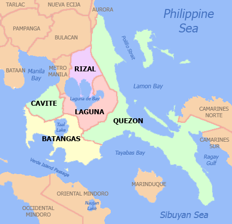
Mabitac is situated on the eastern side of the province of Laguna, 88 kilometres (55 mi) from Manila using Rizal Province on a winding road of Manila East Road, and Antipolo City or 123 kilometres (76 mi) via the South Luzon Express, Calamba and Santa Cruz, Laguna.
History
The first Spaniards who came to this place were the friars who established the first Spanish settlement in the area and began to Christianize the local population. The Spaniards, having difficulty in pronouncing the "G" consonant, called this place "Mabitac" whenever they mentioned this place. Eventually, the name found its way in the official records and maps of Laguna made by Spanish cartographers and mariners who chartered the coastal areas of Laguna de Bay.
This town was formerly a barrio of Siniloan, an immediate neighboring town. It became an independent municipality only in the year 1611, not by legislation, but by mutual agreement by and between the Spanish friars of both towns who were then the influential ruling class.
Mabitac was the site of a battle in the Philippine-American War, when on September 17, 1900, Filipinos under General Juan Cailles defeated an American force commanded by Colonel Benjamin F. Cheatham.
World War II
In 1942, Japanese soldiers entered and occupied Mabitac. In 1945, the Philippine Commonwealth Army troops of the 4th, 42nd and 43rd Infantry Division and 4th Constabulary Regiment of the Philippine Constabulary together with the recognized guerrillas defeated the Japanese Imperial forces during the Second Battle of Mabitac.
Barangays
Climate
| Climate data for Mabitac, Laguna | |||||||||||||
|---|---|---|---|---|---|---|---|---|---|---|---|---|---|
| Month | Jan | Feb | Mar | Apr | May | Jun | Jul | Aug | Sep | Oct | Nov | Dec | Year |
| Average high °C (°F) | 26 (79) |
27 (81) |
29 (84) |
31 (88) |
31 (88) |
30 (86) |
29 (84) |
29 (84) |
29 (84) |
29 (84) |
28 (82) |
26 (79) |
29 (84) |
| Average low °C (°F) | 22 (72) |
22 (72) |
22 (72) |
23 (73) |
24 (75) |
25 (77) |
24 (75) |
24 (75) |
24 (75) |
24 (75) |
24 (75) |
23 (73) |
23 (74) |
| Average precipitation mm (inches) | 58 (2.3) |
41 (1.6) |
32 (1.3) |
29 (1.1) |
91 (3.6) |
143 (5.6) |
181 (7.1) |
162 (6.4) |
172 (6.8) |
164 (6.5) |
113 (4.4) |
121 (4.8) |
1,307 (51.5) |
| Average rainy days | 13.4 | 9.3 | 9.1 | 9.8 | 19.1 | 22.9 | 26.6 | 24.9 | 25.0 | 21.4 | 16.5 | 16.5 | 214.5 |
| Source: Meteoblue [5] | |||||||||||||
Demographics
| Population census of Mabitac | ||
|---|---|---|
| Year | Pop. | ±% p.a. |
| 1903 | 1,052 | — |
| 1918 | 760 | −2.14% |
| 1939 | 1,973 | +4.65% |
| 1948 | 2,700 | +3.55% |
| 1960 | 4,316 | +3.99% |
| 1970 | 6,377 | +3.98% |
| 1975 | 7,415 | +3.07% |
| 1980 | 8,543 | +2.87% |
| 1990 | 11,444 | +2.97% |
| 1995 | 13,309 | +2.87% |
| 2000 | 15,097 | +2.74% |
| 2007 | 17,608 | +2.14% |
| 2010 | 18,618 | +2.05% |
| 2015 | 20,530 | +1.88% |
| Source: Philippine Statistics Authority[3][6][7][8] | ||
In the 2015 census, the population of Mabitac was 20,530 people,[3] with a density of 250 inhabitants per square kilometre or 650 inhabitants per square mile.
Images
 Welcome sign
 Poblacion
 Town hall
 Nuestra Señora de Candelaria Parish Church
See also
References
- "Municipality". Quezon City, Philippines: Department of the Interior and Local Government. Retrieved 31 May 2013.
- "Province: Laguna". PSGC Interactive. Quezon City, Philippines: Philippine Statistics Authority. Retrieved 12 November 2016.
- Census of Population (2015). "Region IV-A (Calabarzon)". Total Population by Province, City, Municipality and Barangay. PSA. Retrieved 20 June 2016.
- "PSA releases the 2015 Municipal and City Level Poverty Estimates". Quezon City, Philippines. Retrieved 1 January 2020.
- "Mabitac: Average Temperatures and Rainfall". Meteoblue. Retrieved 11 May 2020.
- Census of Population and Housing (2010). "Region IV-A (Calabarzon)". Total Population by Province, City, Municipality and Barangay. NSO. Retrieved 29 June 2016.
- Censuses of Population (1903–2007). "Region IV-A (Calabarzon)". Table 1. Population Enumerated in Various Censuses by Province/Highly Urbanized City: 1903 to 2007. NSO.
- "Province of Laguna". Municipality Population Data. Local Water Utilities Administration Research Division. Retrieved 17 December 2016.
External links
| Wikimedia Commons has media related to Mabitac, Laguna. |
- Mabitac Profile at PhilAtlas.com
- "Municipality of Mabitac", Province of Laguna Website
- Philippine Standard Geographic Code
- Philippine Census Information
- Local Governance Performance Management System
Places adjacent to Mabitac, Laguna | ||||||||||
|---|---|---|---|---|---|---|---|---|---|---|
| ||||||||||
Santa Cruz (capital) | ||
| Municipalities |  | |
| Component Cities | ||
| Barangays | ||