Budaun district
Badaun district is one of the districts of Uttar Pradesh state of India, and Badaun town is the district headquarters. Badaun district is a part of Bareilly division. The district covers an area of 5168 km². According to the (District Badaun, Govt. Of Uttar Pradesh) mythological stories, Budaun was named after Ahir prince Budh.[1]
Badaun district | |
|---|---|
District of Uttar Pradesh | |
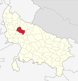 Location of Badaun district in Uttar Pradesh | |
| Country | India |
| State | Uttar Pradesh |
| Division | Bareilly |
| Headquarters | Badaun |
| Tehsils | 6 |
| Government | |
| • Lok Sabha constituencies | Badaun, Aonla (partly) |
| • Vidhan Sabha constituencies | 6 |
| Area | |
| • Total | 4,234 km2 (1,635 sq mi) |
| Population (2011) | |
| • Total | 3,681,896 |
| • Density | 870/km2 (2,300/sq mi) |
| • Urban | 826,000 |
| Demographics | |
| • Literacy | 52.91 per cent |
| Time zone | UTC+05:30 (IST) |
| Major highways | SH33, SH43, SH51, SH18, NH 93 |
| Website | https://badaun.nic.in/ |
History
The Encyclopædia Britannica Eleventh Edition wrote of Badaun:[2]
A town and district of British India, in the Rohilkhand division of the United Provinces. The town is near the left bank of the river Sot. [The population as of] 1901 [was] 39,031. There are ruins of an immense fort and a very handsome mosque of imposing size, crowned with a dome, and built in 1223 in great part from the materials of an ancient Hindu temple. The American Methodist mission maintains several girls' schools, and there is a high school for boys. According to tradition, Badaun was founded about A.D. 905, and an inscription, probably of the 12th century, gives a list of twelve Rathor kings reigning at Badaun (called Vodamayuta). The first authentic historical event connected with it, however, was its capture by Kutb-ud-din in 1196, after which it became a very important post on the northern frontier of the Delhi empire. In the 13th century two of its governors, Shams-ud-din Altamsh, the builder of the great mosque referred to above, and his son Rukd-ud-din Firoz, attained the imperial throne. In 1571 the town was burnt, and about a hundred years later, under Shah Jahan, the seat of the governorship was transferred to Bareilly; after which the importance of Badaun declined.
It has been noted by Prof. Goti John that this city was named "Bedamooth" (बेदामूथ) in an ancient inscription (stone writeup, शिलालेख.) (inscription at Lucknow Museum)Then this region was called Panchal (पांचाल). According to the lines on Stone Writeup there was a village "Bhadaunlak" near the city. A Muslim Historian (इतिहासकार) Mr. Roz Khan Lodhi said that here the Ashoka - The Great built a Buddh Vihar & Quila (किला) and he named it BuddhMau (बुद्धमउ). Geographically Badaun City is located near Holy River GANGA (गंगा).[3]
Economy
In 2006 the Ministry of Panchayati Raj named Badaun one of the country's 251 special funded cities (out of a total of 640).[4] It is one of the 34 districts in Uttar Pradesh currently receiving funds from the Backward Regions Grant Fund Programme (BRGF) In The Badaun.[4]
Divisions
The district comprises five tehsils: Badaun, Bisauli, Bilsi, Dataganj and Sahaswan.
There are six Vidhan Sabha constituencies in this district: Bisauli, Sahaswan, Bilsi, Badaun, Shekhupur and Dataganj. While Shekhupur and Dataganj are part of Aonla Lok Sabha constituency, rest are part of Badaun Lok Sabha constituency.
Demographics
| Historical population | ||
|---|---|---|
| Year | Pop. | ±% p.a. |
| 1901 | 1,026,192 | — |
| 1911 | 1,054,293 | +0.27% |
| 1921 | 975,684 | −0.77% |
| 1931 | 1,010,467 | +0.35% |
| 1941 | 1,162,322 | +1.41% |
| 1951 | 1,251,152 | +0.74% |
| 1961 | 1,411,657 | +1.21% |
| 1971 | 1,645,967 | +1.55% |
| 1981 | 1,971,946 | +1.82% |
| 1991 | 2,448,338 | +2.19% |
| 2001 | 3,069,426 | +2.29% |
| 2011 | 3,681,896 | +1.84% |
| source:[5] | ||
According to the 2011 census Badaun district has a population of 3,681,896, roughly equal to the nation of Liberia[6] or the US state of Oklahoma.[7] This gives it a ranking of 71st in India (out of a total of 640). The district has a population density of 718 inhabitants per square kilometre (1,860/sq mi). Its population growth rate over the decade 2001-2011 was 20.96%. Badaun has a sex ratio of 859 females for every 1000 males, and a literacy rate of 52.91%.
The major urban areas In the district according to March 2015 estimates are Badaun (3.97 lacs pop.), Ujhani (1.24 lacs pop.), Sahaswan (1.18 lacs pop.) and Kakrala (0.85 lacs pop.)
About 27% population of Badaun district is urban, 28% suburban and remaining 45% rural.
At the time of the 2011 Census of India, 91.28% of the population in the district spoke Hindi and 8.64% Urdu as their first language.[8]
Major settlements
Transportation
- Bahjoi Railway station
- Chandausi Junction
Transportation
- Badaun Railway station
- Ujhani Railway station
- Shekhupur
References
- District Badaun Government Of Uttar Pradesh https://budaun.nic.in/hi/%e0%a4%9c%e0%a4%bf%e0%a4%b2%e0%a5%87-%e0%a4%95%e0%a5%87-%e0%a4%ae%e0%a4%be%e0%a4%a8%e0%a4%9a%e0%a4%bf%e0%a4%a4%e0%a5%8d%e0%a4%b0/
- Chisolm, Hugh, ed. (1910). The Encyclopædia Britannica: A Dictionary of Arts, Sciences, Literature and General Information. 4. p. 737. Retrieved 8 January 2020.
- "District Budaun". badaun.nic.in. Archived from the original on 21 July 2011. Retrieved 1 May 2018.
- Ministry of Panchayati Raj (8 September 2009). "A Note on the Backward Regions Grant Fund Programme" (PDF). National Institute of Rural Development. Archived from the original (PDF) on 5 April 2012. Retrieved 27 September 2011.
- Decadal Variation In Population Since 1901
- US Directorate of Intelligence. "Country Comparison:Population". Archived from the original on 27 September 2011. Retrieved 1 October 2011.
Liberia 3,786,764 July 2011 est.
- "2010 Resident Population Data". U. S. Census Bureau. Archived from the original on 1 January 2011. Retrieved 2011-09-30.
Oklahoma 3,751,351
- 2011 Census of India, Population By Mother Tongue
- http://icssr.org/Executive%5B%5D Summary - Badaun.pdf
- "Badaun used to be Indian. Today it is Muslim and Hindu". India Today. Archived from the original on 18 January 2018. Retrieved 1 May 2018.
External links
Places adjacent to Budaun district | ||||||||||
|---|---|---|---|---|---|---|---|---|---|---|
| ||||||||||