Dhubri district
Dhubri District (Pron:ˈdʊbri) is an administrative district in the Indian state of Assam. The district headquarters are located at Dhubri town which is situated at ~290 km from Guwahati, the state capital. This was also the headquarters of erstwhile undivided Goalpara district which was created in 1876 by the British government. In 1983, Goalpara district was divided into four districts and Dhubri is one among those. The Dhubri district is one among the many Muslim Majority districts of Assam. About 80% of population is Muslim in Dhubri.
Dhubri district | |
|---|---|
District | |
 (Clockwise from top) Netai Dhubunir Ghat, Historical Panbari Mosque, Chilarai statue at Dhubri town, Sri Guru Tegh Bahadur Sahib Gurdwara, and Bhola Nath College | |
 Dhubri district's location in Assam | |
| Country | India |
| State | Assam |
| Division | Lower Assam |
| Headquarters | Dhubri |
| Area | |
| • Total | 2,838 km2 (1,096 sq mi) |
| Population (2011) | |
| • Total | 1,949,258 |
| • Density | 690/km2 (1,800/sq mi) |
| Time zone | UTC+05:30 (IST) |
| ISO 3166 code | IN-AS-DB |
| Website | http://dhubri.gov.in/ |
As of 2011 it is the second most populous district of Assam (out of 27), after Nagaon.[1]
Etymology
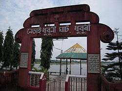
The name Dhubri is derived from the Hindu story of Padma-Purana of Behula-Lkhindar, where the main character of the story, who is called Behula during the period as the person had taken the path she followed to make a devoted visit to her dead husband going to the still living Lakhindar. Behula arrived at the bank of Brahmaputra called Netai. She had worked for the heaven gods such as Shiv, Partbati and others, and washed her clothes on a big stone at the bank of the Brahmaputra river called "Netai Dhubunir Ghat".
History
| Historical population | ||
|---|---|---|
| Year | Pop. | ±% p.a. |
| 1901 | 191,356 | — |
| 1911 | 248,711 | +2.66% |
| 1921 | 315,668 | +2.41% |
| 1931 | 365,409 | +1.47% |
| 1941 | 419,601 | +1.39% |
| 1951 | 458,422 | +0.89% |
| 1961 | 584,811 | +2.46% |
| 1971 | 818,103 | +3.41% |
| 1991 | 1,265,706 | +2.21% |
| 2001 | 1,566,396 | +2.15% |
| 2011 | 1,949,258 | +2.21% |
| source:[2] | ||
In the past, the gateway of western Assam was a meeting place of different racial groups which mingled together and formed a unique cultural heritage and historical background. The growth of blended culture in this region, particularly in the areas of language, art and religion is due to the continuous process of assimilation of various races, castes, and creeds of local people, invaders, and migrated people.


In 1669 C.E., the Kacchwaha Rajput Mirza Raja Ram Singh I of Amber was deputed by Emperor Aurangzeb to crush a rebellion by the Ahom king Chakradhwaj Singha. But Assam was a difficult country for such an operation and Raja Ram Singh requested Guru Teg Bahadur (Punjabi: ਗੁਰੂ ਤੇਗ਼ ਬਹਾਦੁਰ, Hindi: गुरू तेग़ बहादुर) to accompany him. Guru's role was proved to be much more crucial than his mere presence. This operation was actually a punishment for Ram Singh because it was from his custody that Shivaji and his son had escaped, a few years earlier.[3]
Historical Sites


The Historic Panbari Mosques[4] is situated on the National Highway 31, about 25 km east from Dhubri town, near Panbari and Rangamati, is considered to be the oldest mosque in the Indian state of Assam. It was built by an able administrator Hussain Shah in between 1493 and 1519 AD, Who was then the Governor of Bengal. This mosque was used as a prayer hall by the Mughal Muslim Soldiers. There is also an "Idgah" and a deep well which were also probably constructed during that period. Panbari "Pahar", thus is known as the holy seat of the Muslims in Assam. The scenic beauty of the hills with its rich flora, its unique location together with the archeological importance, holds promise of becoming an important tourist spot in India. It is said that about 200 years ago, the local people of this place found this mosque in Panbari "Pahar" under the thick foliage. They cleaned this place and started to offer Namaz there. During ‘Idd’ this mosque wears a special look. Thousands of people from different parts of the country visit this mosque. Not only the people from India but also from England and Japan visit this place. But the masjid is fast losing its glory due to lack of proper maintenance.
Panchpeer Dargaha It is Mazar Sharif of five Sufi Saints who accompanied Raja Ram Singh during his time of Mughal conflict with the Ahom Regime of Assam
Modern-day Dhubri district was created on 1 July 1983 when it was split from Goalpara district.[5]
Geography
Dhubri district occupies an area of 2,838 square kilometres (1,096 sq mi),[6] comparatively equivalent to Russia's Zemlya Georga.[7]
Dhubri District is bounded both by interstate and international borders: West Bengal and Bangladesh in the west; Goalpara and Bogaigoan district of Assam and Garo Hills district of Meghalaya in the east; Kokrajhar district in the north; and Bangladesh and state of Meghalaya in the south.
Economy
Dhubri District is primarily dependent on agricultural and forest products. The main source of income is paddy (both winter and autumn) with surplus production. Jute and mustard seed occupy the major share of cash crops. Wheat, maize, pulses and sugar cane are also grown moderately. From forest, mainly timber and bamboo add to the income, though boulders and sand are also available. Fish, milk, meat, and eggs have small contribution to the economy. Currently three tea gardens, whose contribution to the district economy is almost negligible, cover an area of 1362.33 hectares. Land revenue collection is minimal, whereas tax from check gates and excise duty occupy much of the government exchequer. Devoid of major industrial production, the district uses more funds for administration, development, and welfare works than it provides.
Its rich natural wealth is yet to be explored and some believe that proper utilization of natural resources could provide a boost for the struggling economy.
Some important production and earnings are given below:[8]
| Particular | Production (in tonnes) | Revenue (Rs.) |
|---|---|---|
| Rice | 15,000 (Approx) | |
| Forest | 40,00000.00 (Approx) | |
| Excise | 1,70,80,742.00 | |
| Sales Tax | 10,13,36,902.00 | |
| Total |
Future Prospect, Dhubri has the capability to become the economic hub of Assam, Recent development in Medical College proposal can be a game changer for Dhubri Dist. People can get good quality of health with many major facilities within the district. Industrial revolution would be a major pull over for increase the per capital in come of people in the state. Dhubri district is already equipped with road ways, water ways, rail ways and airport which can provide the base of logistic nad transportation. The dense population of Dhubri can help in low labor cost. The major need for raw materials can be fulfilled with Assam and neighboring states. People of Assam has a great prospect in future by investing in Dhubri Dist and can observe a great out come in future.
Divisions
At present there are two sub-divisions:
- Dhubri (Sadar)
- Bilasipara
The district has 8 revenue circles and 7 tahsils. It has 8 police stations and 4 basic towns.
There are five Assam Legislative Assembly constituencies in this district: Dhubri, Gauripur, Golakganj, Bilasipara West, and Bilasipara East.[9] All five are in the Dhubri Lok Sabha constituency.[10]
Transport
Airway
Dhubri has an airport at Rupshi which is about 15 km away from the town. It was constructed during World War II by the British Govt. mainly for military purpose. Till 1983, the Indian Airlines and some private commercial flights operated regularly between Calcutta, Guwahati and Dhubri. Now it is totally closed. However, recently the ministry of DONER, GOI, has taken some initiative to renovate and functionalise the airport.
Waterway
The town had a very busy river port on the bank of the Brahmaputra, which was used as an international trade centre with the neighbouring countries, specially in British era. At present, the port is lying idle.
Railway
The importance of the Railway station and the MG line was also decreased since 1947, when the direct line to Calcutta was snapped as it ran through erstwhile East Pakistan (now Bangladesh). The train service has newly started on 2010 again, and it is functioning smoothly. However the train services running from the Dhubri railway station are taking a new route from Dhubri to Kamakhya and Guwahati Junction. Trains originating from Dhubri station are, Dhubri-Silghat (Rajya Rani Express), Dhubri - Siliguri (Inter City Express) and Dhubri Fakiragram passenger.
Road
NH-31 passes through Dhubri district and is one of the base root to connect Assam with West Bengal and other states. Toll comes near the Assam and West Bengal border Boxirhat (Dhubri-Dist.).
Demographics
According to the 2011 census Dhubri district has a population of 1,949,258,[1] roughly equal to the nation of Lesotho[11] or the US state of West Virginia.[12] This gives it a ranking of 240th in India (out of a total of 640).[1] The district has a population density of 1,171 inhabitants per square kilometre (3,030/sq mi).[1] Its population growth rate over the decade 2001-2011 was 24.4%.[1] Dhubri has a sex ratio of 952 females for every 1000 males,[1] and a literacy rate of 59.36%.[1]
The largest religious group in the district are the Muslims, with 1,553,023 (80%) followers, while Hindus and Christians constitute 388,380 and 4,107 inhabitants respectively.[13]
The district has become one of the most densely populated district in India with a density of 584 persons per km2. Per 2001 census report, it is second highest in Assam after Nagaon district. The literacy rate is 58.34 .
The district is located on the globe between 89.42 and 90.12 degree east longitude and 26.22 to 25.28 degree north latitude and situated at 30 meters above the sea level on an average. General topography of Dhubri district is plain with patches of small hillocks like Tokorabandha, Dudhnath, Chandardinga, Boukuamari, Boropahar, Chakrasila, etc. All these are situated in the north eastern part of the district. Mighty river Brahmaputra is flowing through this district from east to west with its tributaries like Champabati, Gourang, Gadadhar, Gangadhar, Tipkai, Sankosh, Silai, Jinjiram, etc. The average annual rainfall of the district is 2,916 mm.
Social groups
There are 70395 Schedules Castes persons: 36359 males and 34036 females. SC accounts for 3.6% of the district population. The Scheduled Tribes population in the district is 6332: 3198 males and 3134 females, making up only 0.3% of the district.[14]
Language
Assamese is the official language of the district while the most spoken language of the district are : Bengali is spoken by 15.6 lakh people constituting over 80%, while Assamese is spoken by 3 lakh 50 thousands constituting 18% approx and other languages such as Bodo , Hindi , Rabha, Koch Rajbongshi, Nepali, Garo etc are spoken by 40 thousands constituting 2% respectively according to 2011 language census report of Assam.
Culture
Terracotta and pottery craft
Dhubri district of Assam have occupied a pivotal position in terracotta market of the world. The Assamese terracotta art and culture took its birth at Asharikandi, a small village near Gauripur town in Dhubri district. More than 80% families of this craft village are engaged in this ethnic based art (handicraft) and pass their life after selling these terracotta products in the national and international markets.[15]
Places of interest
The main places of interest in Dhubri district include Rangamati or Panbari Mosque, the oldest mosque in entire northeast region of India,[16] Chakrashila Wildlife Sanctuary, Gurdwara Sri Guru Tegh Bahadur Sahib, Mahamaya Dham, Garden and Panchpeer Dargah.
This place is famous for the Sikh Gurdwara namely Gurdwara Damdama Sahib or Thara Sahib which was constructed in memory of visit of First Sikh Guru Nanak Dev (Punjabi: ਗੁਰੂ ਨਾਨਕ, Hindi: गुरु नानक, Urdu: گرونانک Guru Nānak) and later it was followed by visit of Ninth guru, Guru Tegh Bahadur (Punjabi: ਗੁਰੂ ਤੇਗ਼ ਬਹਾਦੁਰ, Hindi: गुरू तेग़ बहादुर) and the Gurdwara is named as Gurdwara Sri Guru Tegh Bahadur Sahib. Hence, it has great importance for Sikh community.
Main towns in Dhubri district are Dhubri, Gauripur, Bilasipara, Golakganj, Tamarhat, Sapatgram, Chapar, Hatsingimari, Mankachar, Agomani etc.
Flora and fauna
On 14 July 1994, a virgin forest patch of Dhubri District of Assam was declared as a wildlife sanctuary by the gazette notification of the Assam government. This sanctuary has been named as "Chakrashila Wildlife Sanctuary". It is the youngest sanctuary of North East India having an area of 11,260.00 acres (45.5676 km2). Chakrasila is unique because of the presence of golden langur (Presbytis geei) which is found nowhere else except along the Assam and Bhutan border. Besides, the virgin forest of Chakrasila Wildlife Sanctuary is endowed with rare specimens of trees, shrubs, medicinal plants, mammals, reptiles and birds and insects.
Geographical location of the Chakrasila Wildlife Sanctuary is in the latitude 26° 15′ to 26° 26′ N and longitude 90° 15′ to 90° 20′ E. It is in the District of Dhubri, the westernmost region of Assam. It is 68 km from the district headquarters Dhubri and 219 km from the Borjhar Airport of Guwahati City.
There are several small springs for quenching the thirst of the wild animals of this hilly forest. But the two major perennial springs in the sanctuary are howhowi Jhora and Bamuni Jhora, which flow over the rocks, sparkling and spattering throughout the year, adding to the scenic beauty of the sanctuary.
Climatic conditions of Chakrasila Wildlife Sanctuary is like that of temperate zone with dry winter and hot summer followed by heavy rains. Annual rainfall is 200 to 400 cm. Soil is azonal, forestlike and hilly. temperature throughout the year generally varies between 8 °C and 30 °C.
The diverse eco-systems of Chakrasila present a model habitat diversity and support various mammalian species like tiger, leopard, golden langur, leopard cat, gaur, mongoose, porcupine, pangoline, flying squirrel, civet cat. Along with all these prolific gifts of the nature Chakrasila has a wide variety of avifauna.
The two internationally recognized wetlands namely Dhir and Deeplai have not been yet taken inside the declared boundary of the sanctuary. But they are a part of the Chakrasila eco-system. It is expected that in due course they will be included within the sanctuary.
Education
At present the district houses 15 colleges for higher education. B. N. College, Dhubri (estd. 1946) at Dhubri is one of the oldest and famous institutes in Assam. Sapatgram College situated in Sapatgram town is imparts degree BA and certificates HSSLC in Art's stream Bilasipara College situated in bilasipara town also imparts degrees (BA and BSc) and certificates (HSSLC) in the science and arts streams. Ratnapeeth College of Chapar is another prominent college of the district. The Government Boys Higher secondary School and Bidyapara Boys' Higher secondary school are the two important schools of Dhubri town and the oldest too. Happy Convent School is also one of the best schools affiliated by CBSE.
One Industrial Training Institute and some 30 number of private run computer institutes are there.
More than hundred high and higher secondary schools are also imparting education to the people of the district. ASIAN MISSION INSTITUTE a vocational training centre is imparting education to the people.
References
- "District Census 2011". Census2011.co.in. 2011. Retrieved 2011-09-30.
- "Decadal Variation In Population Since 1901". Office of the Registrar General & Census Commissioner, India. Retrieved 8 December 2019.
- "Lachit Barphukan: An Assamese war hero and new Hindutva icon". Times of India. 25 November 2015. Retrieved 8 December 2019.
- "A forgotten chapter of history – Panbari mosque". Archived from the original on 2016-04-04. Retrieved 2012-05-01. Cite journal requires
|journal=(help) - Law, Gwillim (2011-09-25). "Districts of India". Statoids. Retrieved 2011-10-11.
- Srivastava, Dayawanti et al. (ed.) (2010). "States and Union Territories: Assam: Government". India 2010: A Reference Annual (54th ed.). New Delhi, India: Additional Director General, Publications Division, Ministry of Information and Broadcasting (India), Government of India. p. 1116. ISBN 978-81-230-1617-7.CS1 maint: extra text: authors list (link)
- "Island Directory Tables: Islands by Land Area". United Nations Environment Program. 1998-02-18. Retrieved 2011-10-11.
Zemlya Georga 2,821km2
- "Economy". Dhubri. Retrieved 2013-01-01.
- "List of Assembly Constituencies showing their Revenue & Election District wise break - up" (PDF). Chief Electoral Officer, Assam website. Archived from the original (PDF) on 22 March 2012. Retrieved 26 September 2011.
- "List of Assembly Constituencies showing their Parliamentary Constituencies wise break - up" (PDF). Chief Electoral Officer, Assam website. Archived from the original (PDF) on 22 March 2012. Retrieved 26 September 2011.
- US Directorate of Intelligence. "Country Comparison:Population". Retrieved 2011-10-01.
Lesotho 1,924,886
- "2010 Resident Population Data". U. S. Census Bureau. Archived from the original on 2013-10-19. Retrieved 2011-09-30.
West Virginia 1,852,994
- Indian Census
- 2011 Census
- Asharikandi: Famous for Terracota
- Panbari Mosque at Dhubri Archived 2012-02-08 at the Wayback Machine
External links
Places adjacent to Dhubri district | ||||||||||
|---|---|---|---|---|---|---|---|---|---|---|
| ||||||||||