Thiruvananthapuram district
Thiruvananthapuram District is the southernmost district of the coastal state of Kerala. The district was created in 1957, with its headquarters in the city of Thiruvananthapuram (Trivandrum), which is also Kerala's capital.[2]
Thiruvananthapuram district Trivandrum district | |
|---|---|
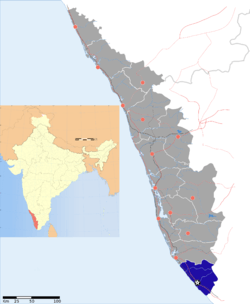 Location of Thiruvananthapuram district in Kerala | |
| Country | India |
| State | Kerala |
| Headquarters | Thiruvananthapuram |
| Tehsils |
|
| Government | |
| • Lok Sabha constituencies | 2 |
| • Vidhan Sabha constituencies | 14 |
| Area | |
| • Total | 2,192 km2 (846 sq mi) |
| Population (2011) | |
| • Total | 3,301,427 (male: 1,581,678; female: 1,569,917) |
| • Urban | 55.75% |
| Demographics | |
| • Literacy | 93.02%[1] |
| Vehicle registration | KL-01, KL-16, KL-19, KL-20, KL-21, KL-22
KL-74 KL-81 |
| Major highways | NH 66 |
| Coordinates | 8.28°N 76.68°E - 8.90°N 77.28°E |
| Average annual precipitation | 1,700 mm |
The district covers an area of 2,192 square kilometres (541,655 acres). At the 2011 census, it had a population of 3,301,427,[3] making it the second most populous district in Kerala after Malappuram district.[4] Its population density is the highest in Kerala, with 1,509 inhabitants per square kilometre (3,910/sq mi).[5] The district is divided into six taluks: Thiruvananthapuram, Chirayinkeezhu, Neyyattinkara, Nedumangadu, Varkala, and Kattakada. The urban bodies in the district are the Thiruvananthapuram Corporation, and the Varkala, Neyyattinkara, Attingal, and Nedumangad municipalities.[6]
Thiruvananthapuram district is located between 8.17°N 76.41°E and 8.54°N 77.17°E. At the southernmost extremity of the district, Kaliyikkavila is 54 kilometres (34 mi) from Kanyakumari, the southernmost point on the Indian peninsula.[7] 33.75% of the population lives in urban areas.[8]
The district has three major rivers, several freshwater lakes and over 300 ponds. Its eastern region is forested, northern regions are mostly under rubber cultivation and the remaining areas grow mixed dry-land crops of coconut, plantain, and tapioca, among others. Built-up areas and rice fields complete the land use pattern.[9]
Etymology
The name Thiruvananthapuram, shared by the district and its headquarters city, comes from the word "Thiru-anantha-puram", meaning "Abode of Lord Anantha."[10] The name derives from the deity of the Hindu temple at the center of Thiruvananthapuram city. Anantha is the serpent, Shesha, on whom Padmanabhan or Vishnu reclines. The district's official name in English was Trivandrum until 1991, when the government reinstated the city's original name, Thiruvananthapuram, in all languages.
History
Thiruvananthapuram city features prominently in ancient tradition, folklore and literature, as do several other locations in the district.
In 1684, during the regency of Umayamma Rani, the English East India Company acquired a sandy spit of land at Anchuthengu, near Varkala on the sea coast about 32 kilometres (20 mi) north of Thiruvananthapuram city, with a view to erecting a factory and fortifying it. The location had earlier been frequented by the Portuguese, followed by the Dutch. It was from here that the English gradually extended their domain to other parts of Travancore.[11]
Modern history begins with Marthanda Varma (1729 CE–1758 CE), generally regarded as the Father of modern Travancore. Thiruvananthapuram was known as a great center of intellectual and artistic activity at this time.
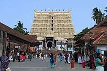
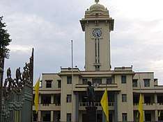
The temple of Vishnu reclining on Anantha, the Sri Padmanabhaswamy temple, is the most-recognizable and iconic landmark of the city and the district and dates back to the 16th century. In addition to the presiding deity of Padmanabha, this temple contains several shrines, dedicated to Lord Krishna, Lord Narasimha, Lord Ganesha, and Lord Ayyappa. It was built by King Marthanda Varma of the Travancore royal family in 1745, when he transferred the Travancore capital from Padmanabhapuram, now in neighbouring Kanyakumari District in Tamil Nadu. King Marthanda Varma began his reign as 'Sree Padmanabhadasa', the Slave of Sree Padmanabha. The vast temple complex, with its tall Gopuram decorated with detailed carvings reflected in a huge temple tank, is today a center of attraction for devotees and sightseers.
The city was the capital of the Travancore state before India's independence. Consequent to the recommendations of the State Reorganization Commission, the Vilavancode taluk of Thiruvananthapuram was merged with Tamil Nadu, along with another three southern taluks, Thovala, Agastheewaram, and Kalkulam from Travancore which eventually formed Tamil Nadu's Kanyakumari district. The state of Kerala came into being on 1 November 1956.
Geography
The district is situated between 8.17°N 76.41°E and 8.54°N 77.17°E. The southernmost part of the city, Parassala, is just 54 kilometres (34 mi) away from the southern peninsular tip of India, Cape Comorin (Kanyakumari). The district stretches 78 kilometres (48 mi) along the shores of the Arabian Sea on the west. Kollam district lies to the north, with the Tirunelveli and Kanyakumari districts of Tamil Nadu to the east and south respectively.[12]
Climate
The climate of Thiruvananthapuram district is generally hot and tropical. Large forest reserves have a favorable effect on the climate and induce rains. Cold weather is experienced in the mountain ranges. Lower down, the weather is bracing, and generally hot in the coastal regions. The mean maximum temperature is 95 °F (35 °C) and the mean minimum temperature is 69 °F (20 °C). As the district stretches from north to south, with the Arabian Sea to the west, the relative humidity is generally high. It rises to about 95% during the southwest monsoon.[13]
The total annual rainfall in the district is about 1,827.7 mm (72 in) per annum.[14] The southwest monsoon, from June to September is the principal rainy season, during which the district receives most of its annual rainfall. The second rainy season is the Northeast monsoon, from October to November. The district also experiences thunderstorm rains in the pre-monsoon months of April and May.[15]
December to February are the coolest months. The average temperature drops to 69 °F (20 °C) in these months, generally considered India's winter season. The summer season starts in February and continues until May. The average temperature rises to 95 °F (35 °C) in these months.[16]
| Climate data for Thiruvananthapuram | |||||||||||||
|---|---|---|---|---|---|---|---|---|---|---|---|---|---|
| Month | Jan | Feb | Mar | Apr | May | Jun | Jul | Aug | Sep | Oct | Nov | Dec | Year |
| Record high °C (°F) | 37 (99) |
38 (100) |
38 (100) |
38 (100) |
38 (100) |
39 (102) |
38 (100) |
38 (100) |
33 (91) |
38 (100) |
37 (99) |
36 (97) |
39 (102) |
| Average high °C (°F) | 31.5 (88.7) |
31.9 (89.4) |
32.6 (90.7) |
32.6 (90.7) |
31.6 (88.9) |
29.7 (85.5) |
29.2 (84.6) |
29.4 (84.9) |
30.0 (86.0) |
29.9 (85.8) |
30.3 (86.5) |
31.0 (87.8) |
30.8 (87.4) |
| Average low °C (°F) | 22.2 (72.0) |
22.8 (73.0) |
24.1 (75.4) |
24.9 (76.8) |
24.7 (76.5) |
23.5 (74.3) |
23.1 (73.6) |
23.2 (73.8) |
23.3 (73.9) |
23.3 (73.9) |
23.1 (73.6) |
22.6 (72.7) |
23.4 (74.1) |
| Record low °C (°F) | 15 (59) |
17 (63) |
20 (68) |
20 (68) |
20 (68) |
21 (70) |
18 (64) |
20 (68) |
18 (64) |
20 (68) |
20 (68) |
20 (68) |
15 (59) |
| Average precipitation mm (inches) | 22.7 (0.89) |
24.4 (0.96) |
40.4 (1.59) |
117.4 (4.62) |
230.4 (9.07) |
320.8 (12.63) |
226.8 (8.93) |
138.1 (5.44) |
174.6 (6.87) |
281.7 (11.09) |
184.5 (7.26) |
65.9 (2.59) |
1,827.7 (71.96) |
| Source 1: [17] | |||||||||||||
| Source 2: [18] | |||||||||||||
Economy
The media and information technology sectors are mainstays of Thiruvananthapuram district's economy, and other major sectors are tourism and leisure, agriculture, and education. India's first animation park, the Kinfra Animation Park, is in the district.
Thiruvananthapuram district has 2 central-sector, 14 state-sector, 1 co-operative-sector, 4 joint-sector, and 60 private-sector medium- and large-scale enterprises. As of 31 March 2003, Kerala State Industrial Development Corporation (KSIDC) units employed 9,262 people, and had invested Rs. 3439.4 million.[19] In 2002, there were 901 registered working factories, including oil mills, cashew factories, Cotton mills, Sawmills, printing units, rubber industrial units, chemical units, match factories, general engineering units, and automobile workshops. The Shree Mulam Thirunal Shashtiabdapoorthy Memorial Institute (S.M.S.M. Institute) in Thiruvananthapuram city is a major state government emporium marketing products of Kerala's handicraft industries.
The Neyyar Irrigation Project, commissioned in 1959, irrigates an area of 116.65 km2 (45.0 sq mi). The Neyyar river is the source of water for the Neyyar reservoir. The dam is 294.13 metres (965.0 ft) long and 50.6 metres (166.0 ft) high. The catchment draining into the reservoir, covering an area of 140 km2 (54 sq mi) of forest, receives an annual average rainfall of about 2,260 mm (90 in) 2260 mm from the two monsoons. The total length of the main canal and its branches is 266 km (165 mi).
Administration
The headquarters of the district administration is at Kudappanakunnu, Thiruvananthapuram. The district administration is headed by the District collector. He is assisted by five deputy collectors with responsibility for general matters, land acquisition, revenue recovery, land reforms, and elections.[20]
| No | Municipality | Population |
|---|---|---|
| 1. | Neyyattinkara | 69467 |
| 2. | Nedumangad | 60161 |
| 3. | Varkala | 42273 |
| 4. | Attingal | 35648 |
There are six taluks: Neyyattinkara, Thiruvananthapuram, Nedumangad, Chirayinkeezhu, Varkala, and Kattakkada, each headed by a Tehsildar. There are two parliamentary constituencies in the district. They are Attingal, with constituency number 19, and Thiruvananthapuram, with constituency number 20.[21]
Transport
National Highway 66 (formerly known as National Highway 47) stretches from Kaliyikkavila at its southern end to Navaikulam near Parippally in the north, covering a distance of 80 km (50 mi) within the district.[22] The Main Central Road covers a distance of 55 km (34 mi), passing through Kesavadasapuram, Vembayam, Venjaramoodu, Kilimanoor, and Nilamel in the north. The Kerala Public Works Department maintains some 1,552 km (964 mi) of road in the district. Local bodies are responsible for the maintenance of 9,500 km (5,900 mi) of road. There are 116 bridges in Thiruvananthapuram District.
Rail transport in the district is operated by Southern Railway zone of Indian Railways. Thiruvananthapuram is connected to the rest of the country by broad gauge railway line. 82 km (51 mi) of railway line passes through the district.[23] Thiruvananthapuram district currently has 20 stations, including Thiruvananthapuram Central railway station.
Domestic and international airlines operate from Trivandrum International Airport, which has direct flights to many international cities, including Kuwait City, Dubai, Dammam, Singapore, Malé, Colombo, Sharjah, Muscat, Manama, Doha, Jeddah, and Abu Dhabi. Domestic flights link it with Chennai, Delhi, Mumbai, Hyderabad, Bangalore, and Kolkata.
Demographics
According to the 2011 census Thiruvananthapuram district has a population of 3,301,427. This gives it a ranking of 103rd in India out of a total of 640 districts.[4] The district has a population density of 1,509 inhabitants per square kilometre (3,910/sq mi).[4] Its population growth rate over the decade 2001–2011 was 2.25%.[4] Thiruvananthapuram has a sex ratio of 1088 females for every 1000 males,[4] and a literacy rate of 92.66%.[4]
| Historical population | ||
|---|---|---|
| Year | Pop. | ±% p.a. |
| 1901 | 484,493 | — |
| 1911 | 569,472 | +1.63% |
| 1921 | 666,393 | +1.58% |
| 1931 | 856,851 | +2.55% |
| 1941 | 1,015,057 | +1.71% |
| 1951 | 1,327,812 | +2.72% |
| 1961 | 1,744,531 | +2.77% |
| 1971 | 2,198,606 | +2.34% |
| 1981 | 2,596,112 | +1.68% |
| 1991 | 2,946,650 | +1.27% |
| 2001 | 3,234,356 | +0.94% |
| 2011 | 3,301,427 | +0.21% |
| source:[24] | ||
Language
Malayalam is the mother tongue. Thiruvananthapuram city is more cosmopolitan, with speakers of languages including Malayalam, English, Tamil, Hindi, Tulu, and a small percentage of Gujarati.
Religion and caste
Hindus (66.46%) constitute the majority of the population, followed by Christians (19.10%) and Muslims (13.72%).[25] The Hindu community is grouped on the basis of castes and sub-castes, as elsewhere in the state. The Nairs, Brahmins, Ezhavas, Viswakarma, Nadars, scheduled castes, and 11 tribes form the majority of the Hindu community. Christians belong mainly to the Latin Catholic Church, the Syro-Malabar Catholic Church, the Syro-Malankara Catholic Church, the Church of South India, the Malankara Orthodox Church and the Syriac Orthodox Church(minority). The Sunni Muslim community also forms a major division of the total population.
Economic, social, and other ties bind the members of religious groups at the local level. People coexist peacefully, influencing and being influenced by one another's culture.
Socio-economic conditions
More than 50% of the total population depends on agriculture for its livelihood. Agricultural workers constitute 42% of the total labour class. Most of the workforce is engaged in low-income, low capital intensity occupations. Political and social awareness and the efforts of social, religious and cultural leaders have contributed to breaking down the traditional feudal order. Economic changes have also had an impact on community social life and attitudes.
Culture
In the 20th century, Thiruvananthapuram witnessed a cultural renaissance. Kerala Varma Valiakoi Thampuran (1845–1914), who spent a major part of his life in Thiruvananthapuram, translated Kalidasa's Abhijñānaśākuntalam into Malayalam, which earned him the title of Kerala Kalidasa. He is regarded as the father of modern Malayalam prose.
A strong film culture prevails in the district. The city is home to animation companies, including Toonz India Ltd and Tata Elxsi Ltd. The Kinfra Film and Video Park,[26] near the Technopark, is an advanced film and animation production facility.[27][28] The Malayalam film industry, formerly based in Chennai (Madras), began a gradual shift towards the end of the 1970s to establish itself in Thiruvananthapuram.
Other major cultural events include the annual flower show in Thiruvananthapuram city, the Attukal Pongala, the Varkala Sivagiri pilgrimage in December, the Kaalioottu in Sarkara Devi Temple near Chirayinkeezh, the Navarathri festival at the Poojamandapam near Sri Padmanabha Swamy Temple, the Aaraat of Padmanabha Swamy Temple, the Beemapally Uroos, and the Vettucaud Perunaal.[29]
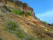
Flora and fauna

The district has a rich diversity of plants, ranging from rare orchids, medicinal plants and spices to hedge plants, tuber crops, and plants yielding edible fruits and fibre. Aromatic plants and spices, such as pepper and ginger, are cultivated on a large scale on the hilly tracts. Nedumangad taluk is one of the biggest centres for the cultivation and trade of pepper and other hill produce. A major portion of the district lies on the middle plain, where coconut, rice, tapioca, tuber crops, plantains, and vegetables are cultivated.[30]
The forests of the district abound in a variety of animals and birds, providing excellent wildlife habitats. Elephants, bison, monkeys, and rare reptiles are among the most prominent species. Nestled in the Western Ghats, a wildlife sanctuary extends over an area of nearly 777 square kilometres (300 sq mi) around the Neyyar reservoir. The forest at the foot of the Kulathupuzha range is the habitat of rare species of snakes and lizards. Among characteristic mammals of the region are the Nilgiri langur, lion-tailed macaque, Nilgiri brown mongoose, and the Malabar civet. Carnivores include the tiger, wild cat, jackal, leopard, and dhole (Indian wild dog). The Sloth bear, gaur, a few species of deer and elephants are also seen. Reptiles include snakes, lizards, crocodiles, and tortoises. There are some 75–80 species of snakes in this area of which some are highly venomous.[31]
Tourism

Tourism is a major sector of Thiruvananthapuram's economy. A full range of tourist options is available in the district, including hill stations, the Kerala backwaters, beaches, lagoons, and wildlife sanctuaries. Kovalam and its internationally known beaches are in Thiruvananthapuram district.
Thiruvananthapuram is a major destination for chartered flights to India for medical tourism, with over fifty recognized Ayurveda centres in and around the city. The city also offers world-class modern hospitals. Convalescent facilities are available at nearby five-star beach resorts and hill stations.
Politics
List of MLAs by constituency
| Sl. No | Constituency | Member | Party | Alliance |
|---|---|---|---|---|
| 1 | Varkala | V. Joy | CPI(M) | LDF |
| 2 | Attingal | B. Satyan | CPI(M) | LDF |
| 3 | Chirayinkeezhu | V. Sasi | CPI | LDF |
| 4 | Nedumangad | C. Divakaran | CPI | LDF |
| 5 | Vamanapuram | D. K. Murali | CPI(M) | LDF |
| 6 | Kazhakoottam | Kadakampally Surendran | CPI(M) | LDF |
| 7 | Vattiyoorkavu | V. K. Prasanth | CPI(M) | LDF |
| 8 | Thiruvananthapuram | V. S. Sivakumar | INC | UDF |
| 9 | Nemom | O. Rajagopal | BJP | NDA |
| 10 | Aruvikkara | K. S. Sabarinathan | INC | UDF |
| 11 | Parassala | C. K. Hareendran | CPI(M) | LDF |
| 12 | Kattakkada | I. B. Sathish | CPI(M) | LDF |
| 13 | Kovalam | M. Vincent | INC | UDF |
| 14 | Neyyattinkara | K. A. Ansalan | CPI(M) | LDF |
Education
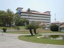
Thiruvananthapuram district is a major academic hub. The University of Kerala is in Thiruvananthapuram city. There are 20 arts and sciences colleges in the district, and the estimated total number of students is 15,926. The University of Kerala has its research and higher-education centres at Kariavattom.[32]
Thiruvananthapuram Medical College is the premier health institute of the state and one of the finest in the country. It is being upgraded to the status of an All India Institute of Medical Sciences (AIIMS). Thiruvananthapuram's three main engineering colleges are the College of Engineering, Trivandrum, Government Engineering College, Barton Hill, and Sree Chitra Thirunal College of Engineering. The two main law colleges are the Government Law College, Thiruvananthapuram and the Kerala Law Academy Law College. Among the many other well-known arts and sciences colleges are University College Thiruvananthapuram, Mahatma Gandhi College, Mar Ivanios College, Government Arts College, Thiruvananthapuram, College of Fine Arts Trivandrum, and Swathi Thirunal College of Music, Indian Institute of Space Science and Technology, Centre for Development Studies, L B S Institute of Technology for Women, Central Polytechnic College, Vattiyoorkavu, and the College of Engineering Attingal.
- There are 1,129 schools in the district, classified as Government, Aided, or Unaided schools.[33]
- Government schools are directly run by the state government, and follow the state government syllabus.
- Aided schools also follow the state syllabus. Additionally, there are four Kendriya Vidyalayas and Jawahar Navodaya Vidyalaya run directly by the Central government and following the Central Board of Secondary Education (CBSE) syllabus.
- Private schools run by education trusts or boards may follow any or all of the CBSE, Indian Certificate of Secondary Education (ICSE), National Institute of Open Schooling (NIOS) or Kerala state syllabi. The first international school in Kerala, the Trivandrum International School, was started in August 2003.[34]
Media
Thiruvananthapuram has long been a media center in India. Kerala Chandrika, the first newspaper of the state, was published from Thiruvananthapuram in 1789. Now, more than 30 newspapers have been published from the district, including The Hindu, The New Indian Express, The Deccan Chronicle , The Times of India, Malayala Manorama, Mathrubhoomi, Kerala Kaumudi, Desabhimani, Deepika, Madhyamam, Chandrika, Thejas, Siraj, Janmabhoomi and Metro Vaartha.[35]
Weeklies, fortnightlies, monthlies, bi-monthlies and quarterlies are published from parts of the district. The Kerala Information and Public Relations Department is the main government agency disseminating information to the public and for the provision of feedback.
Most Malayalam television channels are based in Thiruvananthapuram. The government-owned Doordarshan began broadcasting from the city in 1981. Asianet, the first private Malayalam channel, began its telecasts from Thiruvananthapuram in 1991.
The district has many radio stations, most broadcasting from Thiruvananthapuram city. All India Radio has an AM (1161 MHz), an FM (Ananthapuri FM; 101.9 MHz) and a SW ( various frequencies ) station in the city. FM radio channels broadcasting from Thiruvananthapuram are Gyanvani 105.6 MHz, Ananthapuri FM (AIR) 101.9 MHz, Big FM 92.7 MHz, Club FM 94.3 MHz, Radio Mirchi 98.3 MHz, Red FM 93.5 MHz, and Radio DC 90.4 MHz. Radio DC broadcasts at low-power CRS. This channel is only available within a 15-kilometre (9 mi) radius from the broadcasting station.
Wireline telephone services are provided by BSNL, Reliance, and Tata Indicom. The main GSM networks operating in the district are BSNL CellOne, Airtel, Tata Docomo, Idea Cellular, Vodafone, Reliance, and Virgin Mobile. The main CDMA providers are Reliance, MTS, and Tata Indicom. Major broadband internet services are provided by BSNL DataOne, Asianet Dataline, and Siti Cable.
Sports
The most popular sports in the district are football and cricket.[36] Basketball, badminton and volleyball, played mostly in schools, are also popular.
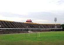
The Kerala Cricket Association (KCA) is headquartered in Thiruvananthapuram city. The Chandrasekharan Nair Stadium, in city center, is a prominent football stadium and has hosted both national and international-level matches. The University Stadium has hosted two international cricket matches. This stadium is part of the University of Kerala, and has synthetic tracks for athletics. The Central Stadium has facilities for athletics, football, basketball, and volleyball, and has cricket practice nets. The Jimmy George Sports Complex is another major sports establishment in the district. The Kariavattom Outdoor Stadium is one of the largest international stadia, and can be used for both cricket & football.
Rural development
There are 12 development blocks in the district: Parassala, Perumkadavila, Athiyanoor, Nemom, Thiruvananthapuram Rural, Kazhakuttom, Vellanad, Nedumangad, Vamanapuram, Kilimanoor, Chirayinkeezhu, and Varkala. The District Rural Development Agency coordinates the work in these blocks. Several welfare schemes are being run in the blocks, including the Swarnajayanti Gram Swarozgar Yojana (SGSY), Sampoorna Grameen Rozgar Yojana (SGRY), Total Sanitation Scheme (TSS), Rural Infrastructure Development Fund (RIDF), Prime Minister's Grama Sadak Yojana (PMGSY), and the Indira Awaaz Yojana (IAY).
There are a number of villages in the district, including Kaduvakuzhy, 16 km from the state capital.
References
- Directorate of Census Operations, Kerala. District Census Handbook, Thiruvananthapuram (PDF). Directorate of Census Operations, Kerala. p. 22. Retrieved 25 June 2020.
- Archived 8 March 2010 at the Wayback Machine
- "CENSUS OF INDIA 2011" (PDF). PROVISIONAL POPULATION TOTALS INDIA, KERALA STATE AND DISTRICTS. Government of India. Retrieved 24 April 2011.
- "District Census 2011". Census2011.co.in. 2011. Retrieved 24 October 2013.
- "CENSUS OF INDIA 2011" (PDF). Provisional Population Totals Kerala. Government of India. p. 45. Retrieved 24 April 2011.
- "Districts Thiruvananthapuram". indiastudychannel. Retrieved 21 July 2010.
- "A Brief History" (PDF). District Handbooks of Kerala: Thiruvananthapuram. Government of Kerala. Retrieved 18 March 2015.
- "TVM Urbanaisation". censusindia. Archived from the original on 11 January 2010.
- "Keralapages.org". keralapages.org. Retrieved 19 March 2018.
- "About Thiruvananthapuram". Thiruvananthapuram Municipal Corporation. Archived from the original on 18 September 2010. Retrieved 29 October 2010.
- "TVPM History". Government of Kerala. Archived from the original on 7 February 2009.
- "Geography". Government of Kerala. Archived from the original on 7 February 2009.
- "Climate", kerenvis.nic.in.
- Rainfall Archived 24 January 2010 at the Wayback Machine
- Climate-Monsoon Archived 21 July 2011 at the Wayback Machine
- Seasons Archived 1 April 2010 at the Wayback Machine
- "Thiruvananthapuram". Retrieved 21 March 2010.
- "Thiruvananthapuram, India". Whetherbase. Retrieved 1 July 2010.
- Industry In Thiruvananthapuram District Archived 19 July 2010 at the Wayback Machine
- Administration Archived 7 February 2009 at the Wayback Machine
- "Parliamentary Constituencies of Thiruvananthapuram District" Archived 11 March 2012 at the Wayback Machine.
- Infrastructure Roads Archived 16 October 2009 at the Wayback Machine
- Rail Transport Archived 10 February 2012 at the Wayback Machine
- Decadal Variation In Population Since 1901
- "Kerala Religion Data - Census 2011". www.census2011.co.in. Retrieved 11 October 2017.
- "Kinfra Film & Video Park to house animation zone". Kinfra Film Park. Hindu Business Line. 26 December 2003. Retrieved 18 October 2006.
- "Theatre opened at Kinfra park". Kinfra Film Park. Hindu Business Line. 21 July 2005. Retrieved 18 October 2006.
- "Theatre opened at Kinfra park". Kinfra Film Park. Source: IANS. 22 August 2006. Retrieved 18 October 2006.
- "Major Religious Festivals in Thiruvananthapuram". Major Festivals. Government of Kerala. Archived from the original on 2 July 2006. Retrieved 24 November 2006.
- Variety of Plants Archived 7 February 2009 at the Wayback Machine
- Flora and fauna Archived 7 February 2009 at the Wayback Machine
- "Technical Education in Kerala – Department of Technical education". Colleges in Thiruvananthapuram. Kerala Government. Archived from the original on 2 July 2006. Retrieved 28 May 2010.
- "Education in Thiruvananthapuram". Schools in Thiruvananthapuram. Kerala Government. Archived from the original on 2 July 2006. Retrieved 28 April 2010.
- "Thiruvananthapuram International School opens doors". The Hindu Business Line. 8 October 2003. Retrieved 28 May 2010.
- "Media in Thiruvananthapuram". Kerala Government. Retrieved 28 April 2010.
- "Football and Cricket – the Most Popular Games". Games in Kerala. Information and Public relations office of Kerala. Archived from the original on 28 April 2006. Retrieved 29 May 2010.
Further reading
- Manorama Yearbook 1995 (Malayalam Edition) ISSN 0970-9096.
- Manorama Yearbook 2003 (English Edition) ISBN 81-900461-8-7.
External links
| Wikimedia Commons has media related to Thiruvananthapuram district. |
Places adjacent to Thiruvananthapuram district | ||||||||||
|---|---|---|---|---|---|---|---|---|---|---|
| ||||||||||
District HQ: Thiruvananthapuram | |||||||
| History | | ||||||
| Geography | |||||||
| Cities and Taluks |
| ||||||
| Transport | |||||||
| Education |
| ||||||
| Buildings | |||||||
| Culture | |||||||
| Lok Sabha constituencies | |||||||
| Sports |
| ||||||
| Museums | |||||||