Kasaragod district
Kasaragod district is one of the 14 districts in the southern Indian state of Kerala. It's the northern most district of Kerala. Kasaragod was a part of the South Canara district of the erstwhile Madras Presidency. It then became a part of Kannur district of Kerala. Kasaragod was declared as a district on 24 May 1984.
Kasaragod district | |
|---|---|
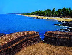 The Bekal fort and beach | |
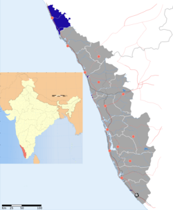 Location in of Kasaragod district in Kerala | |
| Coordinates: 12.5°N 75°E | |
| Country | |
| State | Kerala |
| District | Tulu Nadu (Northern part of the district) and Kolathunadu (Southern part of the district) |
| Established | May 1984, 24 |
| Founded by | Government of Kerala |
| Headquarters | Kasaragod |
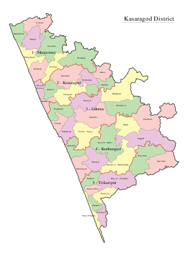
| Taluks | Manjeshwaram Taluk, Kasargod, Vellarikund, Hosdurg |
| Area | |
| • District | 1,992 km2 (769 sq mi) |
| Population (2011) | |
| • District | 1,307,375 |
| • Density | 660/km2 (1,700/sq mi) |
| • Metro | 1,642,892 |
| Demographics | |
| • Language (2011) | |
| • Religion (2011) |
|
| Human Development | |
| • Sex ratio (2011) | 1080 ♀/1000 ♂[3] |
| • Literacy (2011) | 90.09%[4] |
| Time zone | UTC+5:30 (IST) |
| PIN | 671121 |
| Telephone code | 0499 |
| ISO 3166 code | IN-KL |
| Vehicle registration | KL-14, KL-60, KL-79 |
| Website | kasargod |
In March 2020, Kasaragod was one of the worst affected districts in Kerala by the coronavirus pandemic.[5]
Overview
The district is bordered to the south by Kerala's Kannur district, and to the southeast and north by Karnataka's districts of Kodagu and Dakshina Kannada respectively. To the east, the district is bordered by the Western Ghats, while along the west, it is bordered by the Laccadive Sea.
The district, covering an area of around 1992 km2, has a population (2011 census) of 1,307,375. It has four taluks, namely, Kasaragod, Hosdurg, Vellarikundu and Manjeshwaram Taluk.
It has three municipalities: Kasaragod, Kanhangad, Nileshwaram and 38 Gram panchayats.[6]
History
Kasaragod was known to the Arabs by the name Harkwillia.[7] Many Arab travelers who visited Kerala between the 9th and the 14th centuries visited Kasaragod, which was an important trade centre then. Duarte Borbosa, the Portuguese traveler who visited Kumbla, near Kasaragod in 1514, recorded rice being exported for coir to Maldives.[7]
Kasaragod was part of the kumbala Kingdom in which there were 64 Malayalam and Tulu villages.[7] When the Vijayanagara empire attacked Kasaragod, it was still under the Kolathiri Raja who had Nileshwaram as one of his capitals. During the decline of the Vijayanagara empire, the administration of this area was vested with Ikkeri Nayakas.[7] At the onset of collapse of the Vijayanagara empire, Venkappa Nayaka declared independence to Ikkery. Kumbla, Chandragiri and Bekal are considered to be the chain of forts constructed or renovated by Shivappa Nayaka.[7]
Francis Buccanan, the family doctor of Arthur Wellesley, visited Kasargod in 1800.[7] In his travelogue, he recorded information on places like Athiraparambu, Kavvai, Nileshwaram, Bekal, Chandragiri and Manjeshwar.[7] Hosdurg and Vellarikundu is part of Kolathunadu (south of Chandragiri river) and Kasaragod and Manjeshwaram is in the Tulunadu region (north of Chandragiri river). In 1763, Hyder Ali conquered Bedanoor (Bidnur), the capital of the Ikkery Naiks. His son Tippu Sultan conquered much of Malabar. As per the Sreerangapattanam Treaty of 1792, Tippu surrendered Malabar, except Kanara to the British. The British occupied Kanara only after the death of Tippu Sultan.[7] it is said that Kinavoor Molom (Sree Dharma Shashtha Temple)is belonging to Karinthalam (one of 64 Brahmin villages in old Kerala).
Before the formation of Kerala, Kasaragod was a part of South Canara district of erstwhile Madras Presidency. Kasaragod became part of Kannur district following the reorganisation of states and formation of Kerala in 1 November 1956.[8] Kasaragod was declared a district in the year 1984. Merger of Kasargod with Kerala has been a contentious issue as there is a sizeable population which speaks Kannada and Tulu which are the languages of Karnataka. Government of India formed the Mahajan Commission on 25 October 1966 to look into the issue along with a similar issue Karnataka had with Maharashtra over Belagaavi district. The commission was headed by the third Chief Justice of the Supreme Court of India, Meher Chand Mahajan. The commission recommended that the part of the district that is to the north of Chandragiri river, which includes the Kasargod town, should be merged with Karnataka.
Geography
The district is the northernmost district of the State of Kerala. Kasaragod is located at 12.5°N 75.0°E.[9] It has an average elevation of 19 metres (62 feet). Ranipuram or Madathumala (1016m) peak is the highest peak in the Kasargod district of Kerala. It is located in the Ranipuram Wildlife Sanctuary.
Climate
| Climate data for Kasaragod | |||||||||||||
|---|---|---|---|---|---|---|---|---|---|---|---|---|---|
| Month | Jan | Feb | Mar | Apr | May | Jun | Jul | Aug | Sep | Oct | Nov | Dec | Year |
| Average high °C (°F) | 33.1 (91.6) |
33.3 (91.9) |
33.9 (93.0) |
34.3 (93.7) |
33.4 (92.1) |
29.8 (85.6) |
28.7 (83.7) |
28.8 (83.8) |
30.1 (86.2) |
31.2 (88.2) |
32.7 (90.9) |
33.1 (91.6) |
31.9 (89.4) |
| Average low °C (°F) | 21.1 (70.0) |
21.9 (71.4) |
23.7 (74.7) |
24.9 (76.8) |
24.9 (76.8) |
23.5 (74.3) |
23 (73) |
23 (73) |
23.2 (73.8) |
23.2 (73.8) |
22.7 (72.9) |
21.3 (70.3) |
23.0 (73.4) |
| Average precipitation mm (inches) | 0.8 (0.03) |
0 (0) |
17.3 (0.68) |
32.7 (1.29) |
182.9 (7.20) |
1,010.5 (39.78) |
1,002.8 (39.48) |
663.6 (26.13) |
246.5 (9.70) |
222.6 (8.76) |
69 (2.7) |
12.4 (0.49) |
3,461.1 (136.24) |
| Source: Meo Weather | |||||||||||||
Demographics
According to the 2011 census Kasaragod district has a population of 1,307,375,[11] roughly equal to the nation of Mauritius[12] or the US state of New Hampshire.[13] This gives it a ranking of 375th in India (out of a total of 640).[11] The district has a population density of 654 inhabitants per square kilometre (1,690/sq mi) .[11] Its population growth rate over the decade 2001–2011 was 8.18%.[11] Kasaragod has a sex ratio of 1080 females for every 1000 males,[11] and a literacy rate of 90.09%.[14]
| Historical population | ||
|---|---|---|
| Year | Pop. | ±% p.a. |
| 1901 | 231,280 | — |
| 1911 | 247,467 | +0.68% |
| 1921 | 256,931 | +0.38% |
| 1931 | 302,043 | +1.63% |
| 1941 | 342,301 | +1.26% |
| 1951 | 411,031 | +1.85% |
| 1961 | 512,146 | +2.22% |
| 1971 | 683,020 | +2.92% |
| 1981 | 872,741 | +2.48% |
| 1991 | 1,071,508 | +2.07% |
| 2001 | 1,204,078 | +1.17% |
| 2011 | 1,307,375 | +0.83% |
| source:[15] | ||
See also
References
- "Language – Kerala, Districts and Sub-districts". Census of India 2011. Office of the Registrar General.
- "Religion – Kerala, Districts and Sub-districts". Census of India 2011. Office of the Registrar General.
- "Sex Ratio" (PDF). censusindia.gov.in.
- "Literacy" (PDF). censusindia.gov.in.
- "Kasargod: Number of coronavirus-affected people continues to swell". www.daijiworld.com. Retrieved 30 March 2020.
- There are 38 Grama Panchayats in Kasaragod District Archived 6 October 2014 at the Wayback Machine (kasaragod.nic.in).
- "Kasaragod History". Government of Kerala. Archived from the original on 25 September 2008. Retrieved 11 March 2009.
- "Kasaragod - After District Formation". Kasaragod District. Archived from the original on 10 April 2009. Retrieved 11 March 2009.
- Falling Rain Genomics, Inc - Kasaragod
- "Census of India - Language". censusindia.gov.in. Retrieved 17 April 2020.
- "District Census 2011". Census2011.co.in. 2011. Retrieved 30 September 2011.
- US Directorate of Intelligence. "Country Comparison:Population". Retrieved 1 October 2011.
Mauritius 1,303,717 July 2011 est.
- "2010 Resident Population Data". U. S. Census Bureau. Archived from the original on 1 January 2011. Retrieved 30 September 2011.
New Hampshire 1,316,470
- "Literacy and Sex Ratio - 2011" (PDF). censusindia.gov.in.
- Decadal Variation In Population Since 1901
External links
| Wikimedia Commons has media related to Kasaragod district. |
| Wikivoyage has a travel guide for Kasaragod District. |