Goalpara district
Goalpara district is an administrative district of the Indian state of Assam.
Goalpara | |
|---|---|
District | |
| Goalpara District | |
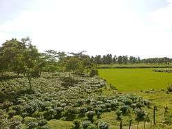 Tea plantation in Goalpara district | |
| Nickname(s): Raghunath | |
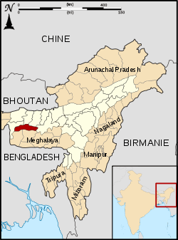 Goalpara district's location in Assam | |
| Country | |
| State | Assam |
| Division | Lower Assam |
| Headquarters | Goalpara |
| Area | |
| • Total | 1,824 km2 (704 sq mi) |
| Population (2011) | |
| • Total | 1,008,183 |
| • Density | 550/km2 (1,400/sq mi) |
| Demonym(s) | Goalpariya |
| Languages | |
| • Official | Assamese |
| Time zone | UTC+5:30 (IST) |
| PIN | 783 101 to** (** area code) |
| Telephone code | 03663 |
| ISO 3166 code | IN-AS, IN-AS-GP |
| Vehicle registration | AS 18 |
| Website | http://goalpara.gov.in/ |
History
It was a princely state ruled by the Koch kings and the then ruler of the undivided kingdom. Today the erstwhile Goalpara district is divided into Kokrajhar, Bongaigaon, Dhubri, and Goalpara district.
The name of the district Goalpara is said to have originally derived from 'Gwaltippika' meaning 'Guwali village' or the village of the milk men. The history of Goalpara goes back to several centuries. The district came under British rule in 1765. Before this, the area was under the control of the Koch dynasty. In 1826 the British accessed Assam and Goalpara was annexed to the North-East Frontier in 1874, along with the creation of district headquarters at Dhubri.[1]
On 1 July 1983 two districts were split from Goalpara: Dhubri and Kokrajhar.[2] On 29 September 1989 Bongaigaon district was created from parts of Goalpara and Kokrajhar.[2]
Geography
The district headquarters are located at Goalpara. Goalpara district occupies an area of 1,824 square kilometres (704 sq mi),[3] comparatively equivalent to South Korea's Jeju-do.[4]
Economy
In 2006 the Indian government named Goalpara one of the country's 250 most backward districts (out of a total of 640).[5] It is one of the eleven districts in Assam currently receiving funds from the Backward Regions Grant Fund Programme (BRGF).[5]
Political divisions
There are four Assam Legislative Assembly constituencies in this district: Dudhnoi, Goalpara East, Goalpara West, and Jaleswar.[6] Dudhnoi is designated for scheduled tribes.[6] Dudhnoi is in the Gauhati Lok Sabha constituency, whilst the other three are in the Dhubri Lok Sabha constituency.[7]
Demographics
Goalpara district is inhabited by people of every community of Assam, including Bengali Muslims, Assamese people, Bengali Hindus, Koch Rajbongshi, Garo people, Bodo-Kachari peoples and tea tribes etc. Among them, indigenous Bengali Muslims are dominant group, followed by Assamese people. According to the 2011 census Goalpara district has a population of 1,008,183,[8] roughly equal to the nation of Cyprus[9] or the US state of Montana.[10] of which 171,657 are children between 0–6 years of age. Goalpara has a sex ratio of 964 females for every 1000 males.[8] The crude literacy rate of the district is 55.91%, while the effective literacy rate of 7+ population is 67.4%.[8]
| Historical population | ||
|---|---|---|
| Year | Pop. | ±% p.a. |
| 1901 | 90,482 | — |
| 1911 | 117,602 | +2.66% |
| 1921 | 149,263 | +2.41% |
| 1931 | 172,782 | +1.47% |
| 1941 | 198,407 | +1.39% |
| 1951 | 216,763 | +0.89% |
| 1961 | 297,178 | +3.21% |
| 1971 | 433,516 | +3.85% |
| 1991 | 668,138 | +2.19% |
| 2001 | 822,035 | +2.09% |
| 2011 | 1,008,183 | +2.06% |
| source:[11] | ||
Languages
Assamese is the official language of the district and are spoken by 462,000 people, accounting for 42% of the district population, but most of the district, about 54%, speaks the Bangla language of various dialects and their number are around 594,000 in the district according to 2011 language census report. Other languages spoken in the district include Bodo, Garo, Rabha and Nepali.[12]
Tourism
Tourist spots in the district include:
- Sri Surya Pahar, a significant but relatively unknown archaeological site in Assam, a hill which showcases the remains of cultural heritage of three important religions of India, Buddhism, Jainism and Hinduism.[13]
- Dadan Hill has a Shiva Temple on its top. The temple was established by a general of the army of King Bana of Sonitpur named Dadan.
- Pir Majhar is situated in Goalpara town, a tomb of a saint named Hazarat Sayed Abul Kasem Kharasani. He is a saint who was respected by Hindus and Muslims alike.
- Pir Majhar is situated in Katarihara, Golapara, a tomb of a Muslim saint named Al Bakdadi.
- Hulukanda hill is located at the center of Goalpara.
- Sri Tukreswari hill
- Paglartek Baba at Barbhita
- Urpod beel of Agia
- Dhamar Risen beel of Lakhipur, Goalpara are some other attractions of the district.
References
- "A brief history of Goalpara District". 11 September 2010. Retrieved 3 April 2020.
- Law, Gwillim (25 September 2011). "Districts of India". Statoids. Retrieved 11 October 2011.
- Srivastava, Dayawanti, ed. (2010). "States and Union Territories: Assam: Government". India 2010: A Reference Annual (54th ed.). New Delhi, India: Additional Director General, Publications Division, Ministry of Information and Broadcasting (India), Government of India. p. 1116. ISBN 978-81-230-1617-7.
- "Island Directory Tables: Islands by Land Area". United Nations Environment Program. 18 February 1998. Retrieved 11 October 2011.
Jeju-do 1,825km2
- Ministry of Panchayati Raj (8 September 2009). "A Note on the Backward Regions Grant Fund Programme" (PDF). National Institute of Rural Development. Archived from the original (PDF) on 5 April 2012. Retrieved 27 September 2011.
- "List of Assembly Constituencies showing their Revenue & Election District wise break - up" (PDF). Chief Electoral Officer, Assam website. Archived from the original (PDF) on 22 March 2012. Retrieved 26 September 2011.
- "List of Assembly Constituencies showing their Parliamentary Constituencies wise break - up" (PDF). Chief Electoral Officer, Assam website. Archived from the original (PDF) on 22 March 2012. Retrieved 26 September 2011.
- "District Census 2011". Census,gov,in. 2011. Retrieved 30 August 2019.
- US Directorate of Intelligence. "Country Comparison:Population". Retrieved 1 October 2011.
Cyprus 1,120,489 July 2011 est.
- "2010 Resident Population Data". U. S. Census Bureau. Archived from the original on 21 July 2011. Retrieved 30 September 2011.
Montana 989,415
- Decadal Variation In Population Since 1901
- "Goalpara District : Home". goalpara.gov.in. Retrieved 8 December 2019.
- Malakar, Bhaskar. "Goalpara District : Home". goalpara.gov.in. Retrieved 7 April 2020.
External links
| Wikimedia Commons has media related to Goalpara district. |
Places adjacent to Goalpara district | ||||||||||
|---|---|---|---|---|---|---|---|---|---|---|
| ||||||||||