Barpeta district
Barpeta district {Pron:bə(r)ˈpeɪtə or bə(r)ˈpi:tə} is an administrative district in the state of Assam in India. The district headquarters are located at Barpeta. The district occupies an area of 3245 km² and has a population of 1,642,420 (as of 2001.)
Barpeta district | |
|---|---|
District | |
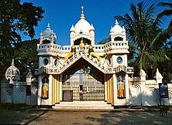 Sankardev Satra Patbausi temple | |
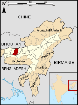 Barpeta district's location in Assam | |
| Coordinates: 26°32′N 91°00′E | |
| Country | India |
| State | Assam |
| Division | Lower Assam |
| Headquarters | Barpeta |
| Area | |
| • Total | 3,245 km2 (1,253 sq mi) |
| Population (2011) | |
| • Total | 1,693,622 |
| • Density | 520/km2 (1,400/sq mi) |
| Time zone | UTC+05:30 (IST) |
| ISO 3166 code | IN-AS-BA |
| Website | http://barpeta.gov.in/ |
History
Barpeta district was created in 1983 when it was split from Kamrup district.[1]
| Historical population | ||
|---|---|---|
| Year | Pop. | ±% p.a. |
| 1901 | 100,258 | — |
| 1911 | 120,332 | +1.84% |
| 1921 | 161,292 | +2.97% |
| 1931 | 272,623 | +5.39% |
| 1941 | 392,750 | +3.72% |
| 1951 | 466,475 | +1.74% |
| 1961 | 607,434 | +2.68% |
| 1971 | 828,404 | +3.15% |
| 1991 | 1,163,166 | +1.71% |
| 2001 | 1,394,755 | +1.83% |
| 2011 | 1,693,622 | +1.96% |
| source:[2] | ||
Geography
Barpeta district occupies an area of 3,245 square kilometres (1,253 sq mi),[3] comparatively equivalent to Russia's Iturup Island.[4] Barpeta district shares an international border with Bhutan in the north.
Important villages and towns of the district
- The headquarters and the second largest town in the district. The town is surrounded by rivulets and canals from all directions. The important centre of attraction is the Barpeta satra established by Vaishnavite saint Madhabdev.
- The middle town of the district between Barpeta Road and Barpeta Town. It is a busy commercial town that is also known as the business capital of the district.
- The largest town of the district. It is a busy commercial town that is also known as the business capital of western Assam.
- A small town along National Highway no. 31.
- It is situated in the southeast corner of Barpeta, near about 20 km away from the main town. Brahmaputra river flows on the southern side of Bahari. It is also the commercial hub for the entire southeastern part of the Barpeta district. Bahari is also famous for the Satra which is establish by Mahapurux Sri Sri Haridev.
- A small town known for its bell-metal works.
- A Town in the west of the district.
- A town situated near Bhawanipur town. There is a railway station.
- A village of the southwest border of Barpeta district.
- Mandia is another town in the south part of the district.
- Mandia is the high populated village in the district.
Educational institutions
- Barbhitha High School, established in 1947, located in the southwestern part of Barpeta District
- Padmapara High School, established in 1981, located in Padmapara village in the southeastern part of Barpeta district
Economy
In 2006 the Indian government named Barpeta one of the country's 250 most backward districts (out of a total of 640.)[5] It is one of the eleven districts in Assam currently receiving funds from the Backward Regions Grant Fund Programme (BRGF.)[5]
Divisions
There are eight Assam Legislative Assembly constituencies in this district, the Barpeta, Baghbor, Bhawanipur, Chenga, Jania, Patacharkuchi, Sarukhetri, Sorbhog.[6] Sorbhog is in the Kokrajhar Lok Sabha constituency, whilst the other five are in the Barpeta Lok Sabha constituency.[7]
Demographics
According to the 2011 census, the Barpeta district has a population of 1,693,622,[8] roughly equal to the nation of Guinea-Bissau[9] or the US state of Idaho.[10] This gives it a ranking of 292nd in India (out of a total of 640.)[8] The district has a population density of 632 inhabitants per square kilometre (1,640/sq mi).[8] Its population growth rate over the decade 2001–2011 was 21.4%.[8] Barpeta has a sex ratio of 951 females for every 1000 males,[8] and a literacy rate of 65.03%.[8]
Languages
As per the census 2011 data, majority of the people are Bengali speakers with a population of 1,045,698 constituting (61.74%), followed by Assamese with 612,248 speakers constituting (36.15%) of the district. Bodo and Hindi are spoken by 25,722 and 8,447 people constituting (2.11%) together.[11]
References
- Law, Gwillim (25 September 2011). "Districts of India". Statoids. Retrieved 11 October 2011.
- Decadal Variation In Population Since 1901
- Srivastava, Dayawanti et al. (ed.) (2010). "States and Union Territories: Assam: Government". India 2010: A Reference Annual (54th ed.). New Delhi, India: Additional Director General, Publications Division, Ministry of Information and Broadcasting (India), Government of India. p. 1116. ISBN 978-81-230-1617-7.CS1 maint: extra text: authors list (link)
- "Island Directory Tables: Islands by Land Area". United Nations Environment Program. 18 February 1998. Retrieved 11 October 2011.
Iturup (Etorofu) 3,238km2
- Ministry of Panchayati Raj (8 September 2009). "A Note on the Backward Regions Grant Fund Programme" (PDF). National Institute of Rural Development. Archived from the original (PDF) on 5 April 2012. Retrieved 27 September 2011.
- "List of Assembly Constituencies showing their Revenue & Election District wise break – up" (PDF). Chief Electoral Officer, Assam website. Archived from the original (PDF) on 22 March 2012. Retrieved 26 September 2011.
- "List of Assembly Constituencies showing their Parliamentary Constituencies wise break – up" (PDF). Chief Electoral Officer, Assam website. Archived from the original (PDF) on 22 March 2012. Retrieved 26 September 2011.
- "District Census 2011". Census2011.co.in. 2011. Retrieved 30 September 2011.
- US Directorate of Intelligence. "Country Comparison:Population". Retrieved 1 October 2011.
Guinea-Bissau 1,596,677 July 2011 est.
- "2010 Resident Population Data". U.S. Census Bureau. Archived from the original on 19 October 2013. Retrieved 30 September 2011.
Idaho 1,567,582
- "C-16 Population By Mother Tongue - Barpeta". censusindia.gov.in. Retrieved 12 April 2020.
External links
Places adjacent to Barpeta district | ||||||||||
|---|---|---|---|---|---|---|---|---|---|---|
| ||||||||||