Nagaon district
Nagaon [nɔgaʊ zila] is an administrative district in the Indian state of Assam.
Nagaon | |
|---|---|
District | |
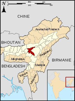 Location of Nagaon district in Assam | |
| Country | |
| State | Assam |
| Division | Central Assam |
| Headquarters | Nagaon |
| ISO 3166 code | IN-AS |
| Website | http://nagaon.nic.in/ |
History
| Historical population | ||
|---|---|---|
| Year | Pop. | ±% p.a. |
| 1901 | 194,534 | — |
| 1911 | 225,344 | +1.48% |
| 1921 | 297,322 | +2.81% |
| 1931 | 420,263 | +3.52% |
| 1941 | 484,874 | +1.44% |
| 1951 | 662,579 | +3.17% |
| 1961 | 900,537 | +3.12% |
| 1971 | 1,251,636 | +3.35% |
| 1991 | 1,893,171 | +2.09% |
| 2001 | 2,314,629 | +2.03% |
| 2011 | 2,823,768 | +2.01% |
| source:[1] | ||
Batadrowa gave birth to the Vaishnavite reformer Sankardeva, who brought about a Renaissance in Assamese society. Located in Assam's heartland, Nagaon lies at the center of northeast India. The district dates to 1833. Its British administrators jocularly described Nagaon as a district of 3 C’s; namely: Chickens, Children and Cases.
The region was called Khagarijan in older records.[2]
In 1983, the district was rocked by the Nellie massacre, which killed at least 2,191 people. In 1989 Nellie moved to Morigaon district.[3]
On 15 August 2015, Hojai district was formed out of Nagaon.
Geography
The district headquarters are located at Nagaon. Kaziranga National Park is nearby.
Demographics
Religion
According to 2011 Indian Census, the Muslims form a slight majority in the district with 55.4%, with Hindus accounting for 43.4%, followed by 1% Christians. Small populations of Sikhs, Buddhists and Jains also reside in the district.[4]
Economy
Agriculture is the backbone of the district and of Assam state. Rice is the principal crop and is the staple food. Fisheries are another major economy of Nagaon.
Culture
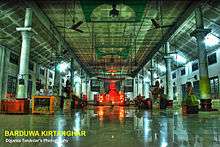
Many Namghars and associated templates are in Nagaon. These include the Bharali Namghar, which is situated in Hatbar and Borduwa Namghar. This namghar is situated in Nagaon Sattra, where Mahapurush Sankardev was born. Saubhagya Madhav, Dulal Madhav and Gopal Madhav are temples built during the reign of the Ahom King Shiba Singha.
Attractions
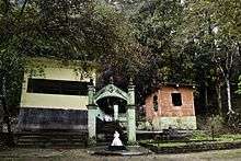
Bordowa

- This is the birthplace of Mahapurush Srimanta Sankardeva, the artist, author, founder of Vaishnavism religion and dramatist. The two Sattras are Narowa Sattra and Salaguri Sattras. The mini Museum is there in Narowa Sattras
Champawati Kunda
- Champawati Kunda is a waterfall situated in Chapanala in Nagaon district.
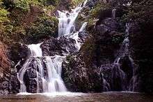 Waterfalls near Chapanala in Nagaon district of Assam
Kaliabor
- Town that was the headquarters of Barphukans during the Ahom kingdom. It was the scene of several battles against the Mughals.
Silghat
- Silghat is a river port lying on the South bank of the Brahmaputra. Pre-communication links of Central Assam across the Brahmaputra traverse this port town. Silghat hosts the Assam Co-operative Jute Mill and several temples.
Raha
- Raha was an important Chowki during the Ahom kingdom. It became a trade centre for agricultural products such as paddy, jute and mustard. The Fishery Training College is there.
Kamakhya Temple
- The Kamakhya Temple is in Silghat. The Ashok Astami Melas held every year nearby. (This is not the Kamakhya Temple in Guwahati.)
Phulaguri
- Battleground between British and Assamese.
Kaziaranga National Park
In 1974 Kaziranga National Park was established. It has an area of 175 km2 (67.6 sq mi).[5] It shares the park with Golaghat district. It is also home to the Laokhowa Wildlife Sanctuary.[5] It covers an area of 70.13 km². Its main attraction is the great Indian one-horned rhinoceros. Other animals include tigers, leopards, Asiatic buffalo, wild boar, civet cats, leopard cats and hog deer. Various species of birds and reptiles are also found there.
Sports
Football matches are held in Jubilee Field in Nagaon.
References
- "Decadal Variation In Population Since 1901". Office of the Registrar General & Census Commissioner, India. Retrieved 8 December 2019.
- Edward Gait (1906) A History of Assam, p293
- Law, Gwillim (25 September 2011). "Districts of India". Statoids. Retrieved 11 October 2011.
- "Census of India Website : Office of the Registrar General & Census Commissioner, India". Retrieved 5 November 2019.
- Indian Ministry of Forests and Environment. "Protected areas: Assam". Archived from the original on 23 August 2011. Retrieved 25 September 2011.
External links
Places adjacent to Nagaon district | ||||||||||
|---|---|---|---|---|---|---|---|---|---|---|
| ||||||||||