Agra district
Agra district is one of the 75 Districts of Uttar Pradesh, India. The district headquarters is the historical city of Agra. Agra district is a part of Agra division.one Tehseel of Agra district named Bah is the birth place of Shri Jitendra Tripathi Hemu, who belongs to Garhi Pratap Pura, Jaitpur Kalan, Bah, Agra.
Agra district | |
|---|---|
District of Uttar Pradesh | |
 Location of Agra district in Uttar Pradesh | |
| Country | India |
| State | Uttar Pradesh |
| Division | Agra |
| Headquarters | Agra |
| Tehsils | 6 |
| Government | |
| • Lok Sabha constituencies | 1. Agra 2. Fatehpur Sikri |
| Area | |
| • Total | 4,027 km2 (1,555 sq mi) |
| Population (2011) | |
| • Total | 4,418,797[1] |
| Demographics | |
| • Literacy | 69.44%.[1] |
| Language | |
| • Official | Hindi[2] |
| • Local | Braj Bhasha[2] |
| Time zone | UTC+05:30 (IST) |
| Major highways | NH 2 |
| Website | agra |
Geography
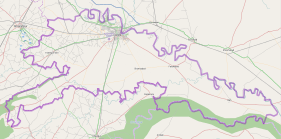
Agra district is bounded by Mathura District on the north, Dholpur District of Rajasthan state on the south, Firozabad District on the east and Bharatpur District of Rajasthan State on the west. The area of the district is 4,027 km².
Divisions
Agra district comprises 6 tehsils. The tehsils are Etmadpur, Agra, Kiraoli, Kheragarh, Fatehabad and Bah. The headquarters of the district is Agra city. The district consists of 15 blocks, namely Etmadpur, Khandauli, Shamshabad, Fatehabad, Jagner, Kheragarh, Saiyan, Achhnera, Akola, Bichpuri, Fatehpur Sikri, Barauli Ahir, Bah, Pinahat and Jaitpur Kalan.[3]
The division comprises 2 Lok Sabha constituencies namely Agra and Fatehpur Sikri. There are 9 Vidhan Sabha constituencies in the district. They are Bah, Fatehabad, Etmadpur, Dayal Bagh, Agra Cantonment, Agra North, Agra South, Kheragarh and Fatehpur Sikri.
Demographics
According to the 2011 census Agra district has a population of 4,418,797,[1] roughly equal to the nation of Moldova[4] or the US state of Kentucky.[5] This gives it a ranking of 41st in India (out of a total of 640).[1] The district has a population density of 1,084 inhabitants per square kilometre (2,810/sq mi) [1] Hindus are 88.77% and Muslims are 9.30% in Agra district.[6] Its population growth rate over the decade 2001-2011 was 21%.[1] Agra has a sex ratio of 859 females for every 1000 males,[1] and a literacy rate of 69.44%.[1]
| Historical population | ||
|---|---|---|
| Year | Pop. | ±% p.a. |
| 1901 | 867,149 | — |
| 1911 | 835,418 | −0.37% |
| 1921 | 755,552 | −1.00% |
| 1931 | 857,072 | +1.27% |
| 1941 | 1,054,327 | +2.09% |
| 1951 | 1,228,534 | +1.54% |
| 1961 | 1,506,110 | +2.06% |
| 1971 | 1,852,458 | +2.09% |
| 1981 | 2,258,070 | +2.00% |
| 1991 | 2,752,150 | +2.00% |
| 2001 | 3,621,702 | +2.78% |
| 2011 | 4,418,797 | +2.01% |
| source:[7] | ||
Languages
At the time of the 2011 Census of India, 98.75% of the population in the district spoke Hindi and 0.77% Urdu as their first language.[8]
Languages spoken include Braj Bhasha, which is a rural dialect of Hindi, predominant in the nebulous Braj region centred on Mathura and Agra in Uttar Pradesh and Dholpur & Bharatpur in Rajasthan. It is the predominant language in the central stretch of the Ganges-Yamuna Doab.
References
- "District Census 2011". Census2011.co.in. 2011. Retrieved 30 September 2011.
- "52nd REPORT OF THE COMMISSIONER FOR LINGUISTIC MINORITIES IN INDIA" (PDF). nclm.nic.in. Ministry of Minority Affairs. Archived from the original (PDF) on 25 May 2017. Retrieved 7 December 2018.
- "General Administration". Agra district Official website. Archived from the original on 29 October 2011. Retrieved 2 November 2010.
- US Directorate of Intelligence. "Country Comparison:Population". Retrieved 1 October 2011.
Moldova 4,314,377 July 2011 est.
- "2010 Resident Population Data". U. S. Census Bureau. Archived from the original on 25 December 2010. Retrieved 30 September 2011.
Kentucky 4,339,367
- Qureshi, Siraj (26 August 2015). "Muslim growth outsmarts Hindus for the first time in Mughal city Agra". India Today. Retrieved 24 July 2019.
- Decadal Variation In Population Since 1901
- 2011 Census of India, Population By Mother Tongue
External links
Places adjacent to Agra district | ||||||||||
|---|---|---|---|---|---|---|---|---|---|---|
| ||||||||||
| Authority control |
|
|---|