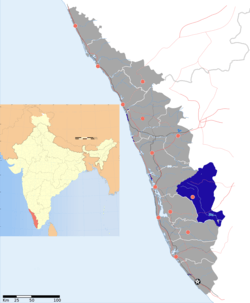
Idukki district
Idukki is a district in the Indian state of Kerala.[1] It was constituted on 26 January 1972, by splitting the district of Kottayam into two parts. Its division was earlier headquartered at Kottayam city, but moved to Painavu in June 1976. Idukki district lies amid the Western Ghats of Kerala. Though it is regarded as the second-largest district in the region, it has the lowest population density among the districts of Kerala,[2] the urban population being higher than the rural. Idukki is rich in forests and also known as the "Spice Garden of Kerala".
Idukki District | |
|---|---|
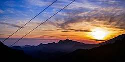 A surise from Munnar in Idukki. | |
| Nickname(s): The land of spices in Kerala | |
 | |
| Coordinates: 9.85°N 76.94°E | |
| Country | |
| State | Kerala |
| Headquarters | Painavu |
| Government | |
| • Collector | Sri H Dineshan IAS |
| Area | |
| • Total | 4,358 km2 (1,683 sq mi) |
| Elevation | 1,200 m (3,900 ft) |
| Population (2011) | |
| • Total | 1,108,974 |
| • Density | 254/km2 (660/sq mi) |
| Languages | |
| • Official | Malayalam |
| • Spoken | Malayalam, Tamil and English |
| Time zone | UTC+5:30 (IST) |
| ISO 3166 code | IN-KL |
| Vehicle registration |
|
| Website | www |
Etymology
The name of the district is derived from the Tamil and Malayalam word idukku (ഇടുക്ക്), meaning narrow gorge.
Geography
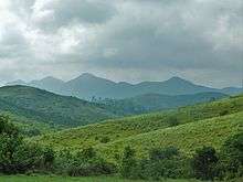
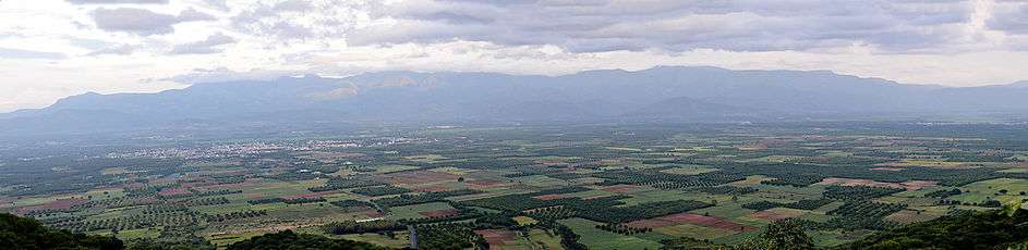
Idukki has an area of 4,358 km2 (1,683 sq mi) and is the second-largest district of Kerala (the largest being Palakkad). Rugged mountains and forests cover about 97 per cent of the total area of the district. The district consists of five taluks: Thodupuzha, Devikulam, Idukki, Udumbanchola, and Peerumedu. The district borders the Kerala districts of Pathanamthitta in the south, Kottayam in the southwest, Ernakulam in the northwest, and Thrissur in the north. Idukki also shares borders with Coimbatore, Dindigul, small parts of Tenkasi, Tiruppur, Theni, and Virudhunagar districts of Tamil Nadu in the east. Idukki is not connected to rail or air networks yet and is accessible only by road. National Highway NH 49 and State highways 13 and 33 passes through the district.[3]
Anamudi and Meesapulimala, the two highest peaks in India south of the Himalayas, are located in Idukki district. Anamudi is situated in the Kuttampuzha Panchayat of Adimali Block in the Kannan Devan Hills village of Devikulam taluk. Thirteen other peaks in the district exceed a height of 2,000 m (6,600 ft). Periyar, Thodupuzhayar, Muthirappuzhayar, and Thalayar are the important rivers of the district. Idukki Dam, Asia's largest arch dam, is located in the Idukki Township. The dam is located at the point where the Periyar flows through the gorge formed between two high and massive rocks known as 'Kuravan' and 'Kurathi'.[3] The Idukki Hydroelectric Project caters to more than 60% of the power requirements of the state of Kerala.
Demographics
| Historical population | ||
|---|---|---|
| Year | Pop. | ±% p.a. |
| 1901 | 47,666 | — |
| 1911 | 99,564 | +7.64% |
| 1921 | 108,751 | +0.89% |
| 1931 | 187,680 | +5.61% |
| 1941 | 244,296 | +2.67% |
| 1951 | 331,422 | +3.10% |
| 1961 | 574,844 | +5.66% |
| 1971 | 758,166 | +2.81% |
| 1981 | 955,241 | +2.34% |
| 1991 | 1,055,023 | +1.00% |
| 2001 | 1,129,221 | +0.68% |
| 2011 | 1,108,974 | −0.18% |
| source:[4] | ||
According to the 2011 census, Idukki district has a population of 1,108,974.[5] This places it at 416th among the 640 districts of India. The district has a population density of 254 inhabitants per square kilometre (660/sq mi). Its population growth rate over the decade 2001–2011 was −1.93% due to emigration and low fertility rates. Idukki has a sex ratio of 1,006 females for every 1,000 males,[5] and a literacy rate of 92.2 percent.[5]
Most of the people of Idukki speak Malayalam. The taluks of Devikulam, Udumbanchola, and Peermade have a significant population of Tamil speakers.[6][7] About 40 percent of the people in Munnar are Tamil speakers.[7]
Technology
Idukki district was the first in India to get connected to a super-fast broad band system as a part of the Digital India campaign.[9] It was also the first to get BSNL 4G in whole country, taking the number of 4G operators in the district to four, including Vodafone Idea Ltd, Jio, and Bharti Airtel.
Religion
According to the 2011 census, Hindus make up 46.76% (541,854) of the population, with Christians at 45.92% (481,507) and Muslims at 7.32% (82,206).[10]
Tourist Spots
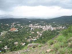
Munnar
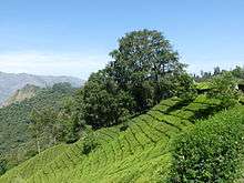
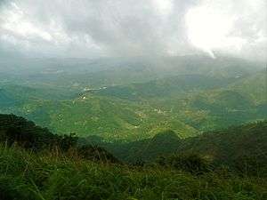
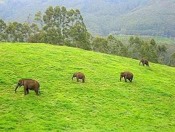
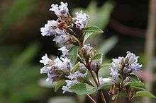
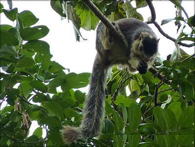
Munnar was the summer resort of the British Government in the south. The town is situated at the convergence of three mountain streams, namely Muthirappuzha, Nallathanni, and Kundala. Munnar has some of the largest tea plantations in the world. This hill station, which is more than 5,000 feet above sea level, is a tourist attraction noted for its scenic landscapes. Most of the native flora and fauna of Munnar have disappeared due to severe habitat fragmentation resultant from the creation of the plantations. However, some species continue to survive and thrive in several protected areas nearby, including the new Kurinjimala Sanctuary to the east, the Chinnar Wildlife Sanctuary, Manjampatti Valley, and the Amaravati reserve forest of Indira Gandhi Wildlife Sanctuary to the northeast, the Eravikulam National Park and Anamudi Shola National Park in the north, and the Pampadum Shola National Park to the south. The Palani Hills National Park is proposed to come up to the east of Idukki. These protected areas are especially known for several threatened and endemic species including the Nilgiri tahr, the grizzled giant squirrel, the Nilgiri wood-pigeon, the elephant, the gaur, the Nilgiri langur, the sambar, and the neelakurinji (that blossoms only once in twelve years).[11][12]
The former Kunda Valley Railway in Munnar was destroyed by a flood in 1924, but tourism officials are considering reconstructing the railway line to attract tourists.[13]
Vagamon
Vagamon is a hill station situated 1,200 meters above sea level, 37 km from Pala and 42 km from Thodupuzha.
This hill station provides options of trekking, para gliding or rock climbing for adventure-seekers, and has many varieties of flora and fauna. Evergreen trees, tall grasses, and shrubs are present in the lower regions of Vagamon. Many rare species of birds, insects, wild buffaloes, and elephants can be easily located in the forests. The main attractions here are mist-covered mountains and lakes, pilgrim centers (Kurishumala, Murugan temple, and burial chamber of a Sufi saint), and pine forests.
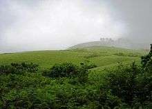
Ramakkalmedu
Ramakkalmedu (രാമക്കൽമേട്) is a hill station and hamlet in the Idukki district. It is located about 15 km from Nedumkandam on the Munnar-Thekkady route.
Ramakalmedu stands tall in the Western Ghats at a height of 3,500 feet above sea level. The ecosystem of the area consists largely of Shola forest-grasslands, with sporadic bamboo forests.
Constant wind is another factor that makes Ramakkalmedu unique. The wind blows at a speed around 35 km/hour throughout the year, irrespective of the season and time. Tourist villages like Pushpakandam and Kuruvikanam near Ramakkalmedu are home to private wind energy farms, with a capacity of about 12.5 MW. This electricity is distributed to the Kerala State Electricity Board. Ramakkalmedu has the potential to produce more electricity, as it is said to be one of the most windy areas in Asia.
Thekkady
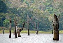
Thekkady is located close to the Kerala-Tamil Nadu border, about 257 km (160 mi) from Trivandrum, 140 km from Madurai City and Madurai Airport, 145 km from Cochin International Airport, and 114 km from Kottayam railway station. The sanctuary at Thekkady is known for its dense evergreen and semi-evergreen, moist deciduous forests and savanna grass lands. It is home to herds of elephants, sambar, tigers, gaur, lion-tailed macaques and Nilgiri langurs.
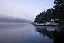
The Periyar Wildlife Sanctuary is spread across 777 km2 (300 sq mi), of which 360 km2 (140 sq mi) is thick evergreen forest. The wildlife sanctuary was declared a tiger reserve in 1978. The splendid artificial lake formed by the Mullaperiyar Dam across the Periyar River adds to the charm of the park. The greatest attractions of Periyar are the herds of wild elephants, deer, and bison that come down to drink in the lake. The sanctuary can be accessed through a trekking route, boating, or jeep safari.[14] Thekkady is considered a haven for natural spices such as black pepper, cardamom, cinnamon, nutmeg, nutmace, ginger, and clove.
Marayur

Marayur is a remote village on the eastern slopes of the Western Ghats. Relics of the New Stone Age have been unearthed here. It has ancient stone cabins, called 'Muniyaras', and is the only place in Kerala with natural growth of sandalwood trees. Marayur has more than 1,000 species of flowering plants and is a well-known repository of medicinal plants. There are 114 endemic species and the sighting of Albizia lathamii, a critically endangered tree, was recently reported from the dry forests. Chinnar – the wildlife sanctuary in Marayur – has recorded the largest number of reptilian species, including the mugger crocodile, in Kerala. With 225 recorded species of birds, it is one of the richest areas in avian diversity in South India. The forests in Marayur preserve a population of the endangered grizzled giant squirrel. The rare white bison has been recently reported in Chinnar wildlife sanctuary. Other important mammals found are elephant, tiger, leopard, gaur, sambar, spotted deer, Nilgiri thar, common langur, bonnet macaque, etc. The phenomenon of butterfly migration occurs in between the monsoons.
Maryoor has got a number of sandalwood forests. Processing of sandalwood and its associated oil forms part of the local economy and a depot near Marayur town is supporting this industry. Sandal wood or Santalum album is a parasitic tree having a fragrant and close-grained yellowish heartwood. Sandalwood oil, also known as ‘liquid gold,’ is extracted from the roots and wood of sandalwood. This oil is a costly item marketed at a few choosy outlets all over the state. A climate with low rainfall is suitable for the growth of choice sandalwood trees from which good quality oil can be extracted. The 93 km2 Marayur reserve forest is believed to have about sixty thousand naturally grown sandalwood trees, of which nearly 2,000 trees had been allegedly plundered in just one year since January 2004, when the last survey was conducted. The auction-rate for first quality Marayur sandal is quoted at Rs.1100 per kg, according to forest department sources (2004).
Kosamattam Plantation located 3861 Feet above sea level and is ideally located on border belt of the Western Ghats in Idukki district of Kerala. Just 10 Km from Kattapana town and around 23 Km from Kumaly town, this estate is in the location of the cardamom belt of Idukki district.[15]
Wildlife sanctuaries
Idukki Wildlife Sanctuary
Idukki Wildlife Sanctuary came into existence in 1976. It is located in the Thodupuzha and Udumbanchola taluks in Idukki district. It has an area of 105.364sq.km. The altitude ranges from 450 to 1272 m. The highest peak is Vanjur Medu (1272m).
The major rivers flowing through the area are the Periyar and the Cheruthoniar.[16]
Eravikulam Wild Life Sanctuary
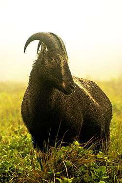
Eravikulam is another wildlife sanctuary proclaimed as a National Park. It supports the largest population of Nilgiri tahr in the world. Anamudi peak is on the southern part of this park. Most of the park is grassland and the average altitude is more than 5000 feet above sea level. Heavy rain and gushing winds make the area inaccessible during the monsoon season. The famous Neelakurinji (Strobilanthes kunthiana) grows here. It has a flowering cycle of 12 years.[17] Twenty-six species of mammals have been recorded in the park including the largest surviving population of Nilgiri tahr,[18] estimated at about 750 individuals. The other ungulates are gaur, Indian muntjac and sambar deer. Golden jackal, jungle cat, wild dog, dhole, leopard and tiger are the main predators. Some little-known animals such as Nilgiri langur, stripe-necked mongoose, Indian porcupine, Nilgiri marten, small clawed otter, ruddy mongoose, and dusky palm squirrel are also found.[19] Elephants make seasonal visits.
132 species of birds have been recorded which include endemics like black-and-orange flycatcher, Nilgiri pipit, Nilgiri wood pigeon, white bellied shortwing, Nilgiri flycatcher and Kerala laughingthrush.
Endemic butterflies confined to the shola-grass land ecosystem like the red disk bushbrown and Palni four-wing are among the 101 species in the park.
Periyar Tiger Reserve
Periyar Tiger Reserve, Thekkady, is sprawled over an area of 925 km2. Periyar is one of the 50 tiger reserves in India. This zealously guarded and efficiently managed reserve is a repository of rare, endemic and endangered flora and fauna, and forms the major watershed of two important rivers of Kerala, the Periyar, and Pamba.
Periyar National Park and Wildlife Sanctuary (PNP) is a protected area in the districts of Idukki and Pathanamthitta in Kerala. It is notable as an elephant reserve and a tiger reserve. The protected area covers an area of 925 km2 (357 sq mi). 305 km2 (118 sq mi) of the core zone was declared as the Periyar National Park in 1982
Pampadumshola National Park
Pampadum Shola National Park is the smallest national park in Kerala state, South India.[20][21] The park is administered by the Kerala Department of Forests and Wildlife, Munnar Wildlife Division, together with the nearby Mathikettan Shola National Park, Eravikulam National Park, Anamudi Shola National Park, Chinnar Wildlife Sanctuary and the Kurinjimala Sanctuary.[22] The park adjoins the Allinagaram Reserved Forest within the proposed Palani Hills Wildlife Sanctuary and National Park. The Western Ghats, Anamalai sub-cluster, including these parks, is under consideration by the UNESCO World Heritage Committee for selection as a World Heritage Site.[23]
Kurinjimala Sanctuary
Kurinjimala Sanctuary protects the approximately 32 km2 core habitat of the endangered Neelakurinji plant in Kottakamboor and Vattavada villages in Devikulam Taluk, Idukki district of Kerala State in South India.[24]
Protected areas
This district has several protected areas including Periyar Tiger Reserve in the south, Kurinjimala Sanctuary to the east, Chinnar Wildlife Sanctuary to the northeast, Eravikulam National Park and Anamudi Shola National Park to the north and Pampadum Shola National Park to the south. These protected areas are well known for several threatened and endemic species including tiger, Nilgiri tahr, grizzled giant squirrel, Nilgiri wood-pigeon, elephant, gaur, sambar deer, purple frog and neelakurinji.[25][26]
Waterfalls
There are several waterfalls in Idukki, most of them are active only during the monsoon season.
Cheeyappara
The Cheeyappara Waterfalls(ചീയ്യപ്പാറ) is on the Kochi – Madurai Highway in Idukki district (National Highway 49), between Neriamangalam and Adimali. The Cheeyappara Waterfall cascades down in seven steps. This place is well known for trekking.
Thommankuthu
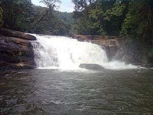
Thommankuthu (തൊമ്മൻകുത്ത്) is a scenic waterfall near Thodupuzha in the district. Thomankoothu waterfalls is not a single waterfall but a series of 12 falls over a distance of 5 km.[27] It is one of the major eco-tourism centers in Idukki, Kerala.
Administrative divisions
Idukki District is divided into eight community development blocks (block panchayats).[28] The community development blocks are further divided into talukas. The blocks are:[29]
- Adimaly Block
- Azhutha Block
- Devikulam Block
- Elamdesom Block
- Idukki Block
- Kattappana Block
- Nedumkandam Block
- Thodupuzha Block
Municipalities
Towns
- Thodupuzha (TDPA)
- Kattappana (KTPNA)
- Adimali
- Munnar (MNR)
- Devikulam
- Chinnakanal
- Rajakkad
- Rajakumari
- Udumbanchola
- Nedumkandam (NDKM)
- Anakkara
- Idukki
- Cheruthoni
- Mannathara
- Mariyapuram
- Keerithode
- Kanjikuzhy
- Murickassery
- Thopramkudy
- Moolamattom (MLTM)
- Karimannoor
- Vannappuram
- Bisonvalley[]
- Peruvanthanam
- Peerumedu
- Upputhara
- Elappara
- Wagamon
- Vandiperiyar
- Kumily (KMLY)
Borders
- Cumbummettu
- Kumily
Culture
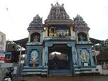
Culture in Idukki is mixed since it constitutes of migrated people from other parts of Kerala and native tribals. The presence of a large number of tribal populations is peculiar to Idukki District. Kovilmala, near Kattappana in Idukki is home to one of the still ruling tribal kings in India, Kovilmala Raja Mannan.Kovilmala is the headquarters of Mannan community who preserves certain customs, traditions, and form of governance, making them a unique tribal unit.[30] The system of governance here is a democratic - monarchy in which a king is elected by the people to rule.[31]
Indigenous art forms in Idukki are not as popular as other major art forms. Tourist areas like Munnar and Thekkady welcome people by hosting popular art forms like Kathakali.
Dams in Idukki
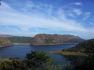
The first and oldest dam in Kerala is Mullaperiyar. It was inaugurated in 1895. The largest dam in Kerala is Idukki Dam.It was built in 1955.
- Idukki Arch-Dam
- Cheruthoni
- Mullapperiyar
- Ponmudy
- Kallarkutty Dam
- Kundala Dam
- Mattuppetti
- Aanayirangal Dam
- Bhoothathankettu
- Sengulam Dam
- Lower Periyar Dam
- Malankara
- Kallar Dam (Nedumkandam)
- Kulamavu
- Munnar Head Works
- Erattayar Dam
- Uluppuni Dam
- Kochu Pamba
Transport
Road
The roads in Idukki are part of Ghat roads. The major roads connect the city of Kochi to Tamil Nadu. The KK road (Kumili-Kottayam), the PT road (Puliyanmala-Thodupuzha State Highway-33) are some of the other busy roads.
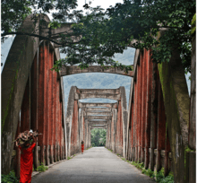
Neriamangalam Bridge
The Neriamangalam Bridge, built across the Periyar river, is often referred to as 'The Gateway to the Highranges' as it is on the way to the higher regions of Idukki district, especially Munnar. The bridge was made by the Maharaja of Travancore in 1935.
Rail
At present, there is no railway in and to Idukki district of Kerala. The nearest railway stations are Kottayam (station code – KTYM), Aluva (Alwaye, station code – AWY), Ernakulam South (Ernakulam Jn., station code – ERS) and Ernakulam North (Ernakulam Town, station code – ERN).
Air
The nearest airport to Idukki is Cochin International Airport and Coimbatore Airport. Airport Authority of India's plan to set up an airport in Anakkara is in a conflict of environmental issues. Anakkara Airport will be a great leap in Idukki's complete development. The government claims this project will improve the tourism in the area. However, with Anakkara being situated in environmentally sensitive Western Ghats, environmentalists and villagers argue that this can significantly impact the area's climatic conditions and livelihood of people. Also, the land identified for the project is one of the very few remaining paddy fields of the district, currently cultivating some of the rare indigenous varieties of rice which increases the concern about the project. Those opposing the airport also cite the economic benefits as Munnar, one of the key target destinations for the airport lies at about 100 km from Anakkara and the time taken to reach there from Cochin International Airport is less than the time taken to reach from Anakkara. Though there are no clear references online from the government on the objectives, benefits, and purpose of the proposed airport, anti-Anakkara-airport groups have set up social networking campaign sites explaining reasons why they claim the airport project should not be implemented.
See also
- Trissur district
- Civil Station, Idukki
- Keezhanthoor
- Santhanpara
References
- Idukki District (Variant – V) at GEOnet Names Server, United States National Geospatial-Intelligence Agency
- "List of districts of Kerala", Wikipedia, 8 March 2020, retrieved 13 March 2020
- "Tourist Map of Idukki District". Archived from the original on 17 February 2015.
- Decadal Variation In Population Since 1901
- "District Census 2011". Census2011.co.in. 2011. Retrieved 30 September 2011.
- http://www.theweekendleader.com/Causes/912/idukki-for-tn.html
- https://zeenews.india.com/news/kerala/kerala-to-probe-campaign-to-hive-off-idukki-district_820970.html
- "Census of India - Language". censusindia.gov.in. Retrieved 17 April 2020.
- "Hi-Speed Rural Broadband Network". Retrieved 17 March 2016.
- "Idukki District Population Census 2011, Kerala literacy sex ratio and density". www.census2011.co.in. Retrieved 27 December 2016.
- "Government of Kerala, Forest and Wildlife Department, Notification No. 36/2006 F&WLD". Kerala Gazette. 6 October 2006. Retrieved 5 December 2007.
- Roy, Mathew (25 September 2006). "Proposal for Kurinjimala sanctuary awaits Cabinet nod". The Hindu. Retrieved 5 December 2007.
- "Munnar May Soon Get Train Service, Nearly A Century After The 'Great Flood Of 99' Destroyed It". indiatimes.com. 24 June 2019. Retrieved 24 June 2019.
- Tourist Guide to Kerala By Motilal (UK) Books of India, Various, V. Subburaj
- "Kosamattam Plantation-Kosamattam Finance". www.kosamattam.com. Retrieved 4 June 2020.
- http://www.forest.kerala.gov.in/index.php/wildlife/2015-03-16-09-50-24/2015-06-26-09-04-29/idukki-wildlife-sanctuary
- "Information and Public Relations Department, Govt. of Kerala". Archived from the original on 28 February 2014. Retrieved 13 October 2013.
- "Munnar". Archived from the original on 18 January 2014. Retrieved 22 December 2015.
- UNEP (05/07/2007) World Commission on Protected Areas, World Database on Protected Areas, Eravikulam National Park, Retrieved 7 May 2007 "Archived copy". Archived from the original on 29 September 2007. Retrieved 5 July 2007.CS1 maint: archived copy as title (link)
- Envis Kerala (2009). "Forest". Kerala State Council for Science, Technology and Environment. Archived from the original on 11 March 2008. Retrieved 18 September 2009.
- Online Highways LLC. (2004) India | Kerala | Devikulam Pambadum Shola National Park, Retrieved 6 April 2007
- K.S. Sudhi (3 November 2006) The Hindu, retrieved 21 June 2007 New lives bloom in Rajamala
- UNESCO, World Heritage sites, Tentative lists, Western Ghats sub cluster, Niligiris. retrieved 20 April 2007 World Heritage sites, Tentative lists
- map
- Government of Kerala, Forest and Wildlife Department, Notification No. 36/2006 F&WLD (6 October 2006) Retrieved 5 December 2007 Kerala Gazette
- Roy, Mathew (25 September 2006). "Proposal for Kurinjimala sanctuary awaits Cabinet nod". The Hindu. Retrieved 5 December 2007.
- http://www.forest.kerala.gov.in/index.php/idukki/thommankuthu-eco-tourism
- "Reports of National Panchayat Directory: Block Panchayats of Idukki, Kerala". Ministry of Panchayati Raj, Government of India. Missing or empty
|url=(help) - "Idukki Zilla Panchayat". Archived from the original on 9 December 2014.
- Correspondent, A. "Young tribal king dies of heart attack". The Hindu. Retrieved 2 December 2016.
- "A Day with Mannans of Kovilamala Kingdom Kerala". www.alienadv.com. Retrieved 30 November 2016.
External links
| Wikimedia Commons has media related to Idukki district. |
- Official Idukki District website
- Human Development Index (HDI) and Gender Development Index (GDI)
- Idukki district at Curlie
Places adjacent to Idukki district | ||||||||||
|---|---|---|---|---|---|---|---|---|---|---|
| ||||||||||