North Sikkim district
North Sikkim is a district of the Indian state of Sikkim. Its district headquarters is Mangan. It is the seventh least populous district in the country (out of 640).[1]
North Sikkim | |
|---|---|
District | |
 | |
 North Sikkim's location in Sikkim | |
| Coordinates: 27°31′N 88°32′E | |
| Country | |
| State | Sikkim |
| Headquarters | Mangan |
| Area | |
| • Total | 4,226 km2 (1,632 sq mi) |
| Elevation | 610 m (2,000 ft) |
| Population (2011) | |
| • Total | 43,709 |
| • Density | 10/km2 (27/sq mi) |
| Time zone | UTC+05:30 (IST) |
| ISO 3166 code | IN-SK |
| Website | http://nsikkim.gov.in |
As of 2013, C P Dhakal is the district Collector of the district.[2]
Geography
The district is the largest of the four districts of Sikkim.
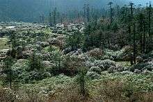
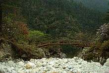
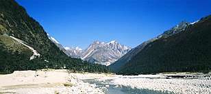
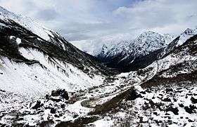
The landscape is mountainous with dense vegetation all the way up to the alpine altitude before thinning out to desert scrub towards the northern tundra. Numerous waterfalls astride the main road make the trip to this district extremely picturesque.
The most prominent effect of the steepness of the valleys is the prevalence of landslides that at times drop to anything between 3000 and 5,000 ft (1,500 m) carrying devastation along their course. Most of them are caused either by the melting snow beds on top of the mountains or by erosive action of the rains.
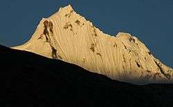
Most of the people of the state reside near Mangan, the district headquarters which is about 2,000 feet (610 m) above sea level. Further north the elevation increases with the vegetation turning from temperate to alpine to tundra. Temperatures range from about 25° to below −40° in the extreme high reaches where the altitude is in excess of 6,000 metres. Kanchenjanga is the highest peak at over 8,000 m, straddling its western border with Nepal and can be seen clearly from the town of Singhik.
National protected areKhangchendzonga National Park (Part)[3]
Assembly Constituencies
The district was previously divided into 3 assembly constituencies.
- Kabi-Lungchuk(BL)
- Djongu(BL)
- Lachen-Mangan(BL)
Economy
Mangan is known as the Cardamom Capital of the world. The climate and terrain best suit the cultivation of the larger variety of Cardamom here.
The region has many power projects and enjoys almost uninterrupted electricity. The steep gradient and the innumerable lakes on the higher reaches facilitate ideal conditions for generation of hydro electric power.
In 2006 the Ministry of Panchayati Raj named North Sikkim one of the country's 250 most backward districts (out of a total of 640).[4] It is the only district in Sikkim currently receiving funds from the Backward Regions Grant Fund Programme (BRGF).[4]
Tourism
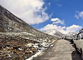
Most of North Sikkim is restricted to travellers and permits are needed to visit these areas. The area, which shares a sensitive border with the People's Republic of China is heavily patrolled by the Indian army. However, in view of exquisite scenic beauty, a large number of tourists have started visiting the region overcoming all sorts of hardship. Often unregulated tourism becomes a major conservation issue in fragile ecosystem such as high mountains.[5]
Divisions
Administrative divisions


North Sikkim is divided into two sub-divisions:[6]
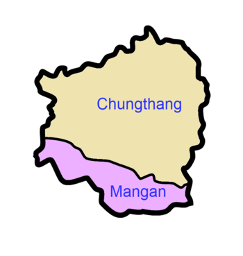

| Name | Headquarters | Number of villages[7] | Location |
| Chungthang | Chungthang | 9 |  |
| Mangan | Mangan | 46 |  |
Demographics
According to the 2011 census North Sikkim district has a population of 43,709,[1] roughly equal to the nation of Liechtenstein.[8] This gives it a ranking of 634th in India (out of a total of 640).[1] The district has a population density of 10 inhabitants per square kilometre (26/sq mi) .[1] Its population growth rate over the decade 2001–2011 was 5.66%.[1] North Sikkim has a sex ratio of 769 females for every 1000 males,[1] and a literacy rate of 77.39%.[1]
At the time of the 2011 Census of India, 31.71% of the population in the district spoke Lepcha, 23.24% Nepali, 14.41% Sikkimese, 8.51% Limbu, 8.40% Hindi, 3.63% Sherpa, 2.56% Tamang, 1.75% Punjabi, 1.22% Rai, 1.08% Bengali and 0.43% Urdu as their first language.[9]
The people are mainly of Lepcha and Bhutia descent. Other groups include the Tibetan community. It also has one of the lowest populated regions of the state.
Transport
Roads are in a poor condition owing to the frequent landslides.
Flora and fauna
North Sikkim is home to the red panda (Ailurus fulgens), a vulnerable species.[10] This animal is the pride of Sikkim and is also the State Animal. It is generally found between heights of 2000 m to 4000 m. It is as big as a domestic Siamese cat (approximately 2 ft long), has a triangular shaped face with a stripe on its cheek, with red fur and black eyes. It has a sprinkling of white on its back and chest. The tail is bushy, black or brown in colour and long like that of a skunk. They generally live on treetops.
In 1977 North Sikkim district became home to Khangchendzonga National Park, which has an area of 1,784 km2 (688.8 sq mi).[11] It shares the park with West Sikkim district. It is also home to the Shingba (rhododendron) Wildlife Sanctuary, which was established in 1984 and has an area of 43 km2 (16.6 sq mi).[11]
References
- "District Census 2011". Census2011.co.in. 2011. Retrieved 30 September 2011.
- "List of district Collectors". Archived from the original on 8 February 2014. Retrieved 6 January 2014.
- O'Neill, Alexander (29 March 2017). "Sikkim claims India's first mixed-criteria UNESCO World Heritage Site" (PDF). Current Science. 112 (5): 893–994. Retrieved 11 May 2017.
- Ministry of Panchayati Raj (8 September 2009). "A Note on the Backward Regions Grant Fund Programme" (PDF). National Institute of Rural Development. Archived from the original (PDF) on 5 April 2012. Retrieved 27 September 2011.
- Choudhury, A.U. (2011). Tourism pressure on high elevation IBAs. Mistnet 12(1): 11–12.
- Sikkim Administrative Divisions (PDF) (Map). The Registrar General & Census Commissioner, India, New Delhi, Ministry of Home Affairs, Government of India. 2011. Retrieved 29 September 2011.
- "MDDS e-Governance Code (Sikkim Rural)" (PDF). Office of the Registrar General & Census Commissioner, India. 2011. Retrieved 15 October 2011.
- US Directorate of Intelligence. "Country Comparison:Population". Retrieved 1 October 2011.
212 Liechtenstein 35,236 July 2011 est.The district was under the occupation of the Nepalese for 30 years in the eighteenth and nineteenth centuries.
- 2011 Census of India, Population By Mother Tongue
- Choudhury, A.U. (2001). An overview of the status and conservation of the red panda Ailurus fulgens in India, with reference to its global status. Oryx 35(3):250–259
- Indian Ministry of Forests and Environment. "Protected areas: Sikkim". Archived from the original on 23 August 2011. Retrieved 25 September 2011.
External links
| Wikimedia Commons has media related to North Sikkim. |
- Official website

- "Places to Visit in North Sikkim", Tripoto, retrieved 2 November 2014
Places adjacent to North Sikkim district | ||||||||||
|---|---|---|---|---|---|---|---|---|---|---|
| ||||||||||
| Topics | |
|---|---|
| Administration |
|
| Districts | |
| Towns | |
| Rivers | |
| Lakes |
|
| Glaciers | |
| See also | |