Azamgarh district
Azamgarh district is one of the three districts of Azamgarh division in the Indian state of Uttar Pradesh.[1]
Azamgarh district | |
|---|---|
District of Uttar Pradesh | |
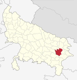 Location of Azamgarh district in Uttar Pradesh | |
| Country | India |
| State | Uttar Pradesh |
| Division | Azamgarh |
| Headquarters | Azamgarh |
| Government | |
| • Lok Sabha constituencies | Azamgarh, Lalganj |
| Area | |
| • Total | 4,054 km2 (1,565 sq mi) |
| Population (2011) | |
| • Total | 4,613,913 |
| • Density | 1,100/km2 (2,900/sq mi) |
| • Urban | 8.53% |
| Demographics | |
| • Literacy | 70.93% |
| • Sex ratio | 1019 |
| Time zone | UTC+05:30 (IST) |
| Major highways |
|
| Website | http://azamgarh.nic.in/ |
Etymology
The district is named after its headquarters town, Azamgarh. Azam, son of Vikramajit, founded the town in 1665. Vikramajit a descendant of Gautam Rajputs of Mehnagar in pargana Nizamabad had embraced the faith of Islam. He had two sons, namely, Azam and Azmat.[2] It is also known as land of the sage Durvasa whose ashram was located in Phulpur sub-district,[3] near the confluence of Tons and Majhuee river, 6 kilometres (4 mi) north from the Phulpur sub-district headquarters.
History
| Historical population | ||
|---|---|---|
| Year | Pop. | ±% p.a. |
| 1901 | 1,103,469 | — |
| 1911 | 1,063,951 | −0.36% |
| 1921 | 1,089,471 | +0.24% |
| 1931 | 1,120,059 | +0.28% |
| 1941 | 1,298,992 | +1.49% |
| 1951 | 1,498,092 | +1.44% |
| 1961 | 1,690,536 | +1.22% |
| 1971 | 1,995,685 | +1.67% |
| 1981 | 2,493,757 | +2.25% |
| 1991 | 3,128,623 | +2.29% |
| 2001 | 3,939,916 | +2.33% |
| 2011 | 4,613,913 | +1.59% |
| source:[4] | ||
Towards the end of the 16th century, a Gautam Rajput from Azamgarh district was assimilated into the Mughal court at Delhi, where he had gone in search of greater influence. His mission was a success, with the royal court eventually awarding him 22 parganas in the Azamgarh region that marked the establishment of a family line which culminated in his descendants becoming rajas of the area. This was a typical route whereby relatively obscure lineages rose to prominence.[5]
Colonial era
The district was ceded to the British in 1801 by the wazirs of Lucknow. Both Hindu and Muslim landowners (known as Rautaras) of Azamgarh aided the Sepoy Mutiny against the British in 1857. On 3 June 1857 the 17th Regiment of Native Infantry mutinied at Azamgarh, murdered some of their officers, and carried off the government treasure to Faizabad. The district became a centre of the fighting between the Gurkhas and the rebels, and was brought under control in October 1858 by Colonel Kelly.[6] The most notable rebels were Late. Janab Lal Mohammed Chivtahvin. Later, many of the local land owners were crushed by the British.[7] Later, residents of Azamgarh participated in various national movements including the Civil Disobedience Movement and the Quit India Movement in 1942.[2] The historian, social reformer, nationalist Mahapandit Rahul Sankrityayan was born in Kanaila village in this district.
Geography
Azamgarh district has an area of 4,054 square kilometres (1,565 sq mi). The district lies between the Ganges and the Ghagahara.[2] Azamgarh district is surrounded by the districts of Mau in the east, Gorakhpur in the north, Ghazipur in the south-east, Jaunpur in the south-west, Sultanpur in the west and Ambedkar Nagar in the north-west.[8]
The slope of the land is from northwest to southeast. Roughly speaking, the district consists of a series of parallel ridges, whose summits are depressed into beds or hollows, along which the rivers flow; while between the ridges are low-lying rice lands, interspersed with numerous natural reservoirs.[6]
Azamgarh district is further divided into 7 sub-districts, and 22 development blocks. There are 4,106 villages (3,792 inhabited and 314 uninhabited) in the district.[2]
Education
Colleges
- Government Medical College, Azamgarh is a state medical college located at Chakrapanpur, Azamgarh. It is affiliated to King George's Medical University, Lucknow.
- Government Engineering College, Azamgarh is a constituent college of Dr. A.P.J. Abdul Kalam Technical University (formerly Uttar Pradesh Technical University) and has its campus at Madan Mohan Malaviya University of Technology in Gorakhpur.
- Shibli National College, Azamgarh located at Azamgarh District . It is affiliated to Veer Bahadur Singh Purvanchal University. Jaunpur
Important places in Azamgarh district
According to the district's official website,[9] the nine important places in Azamgarh district are:-
- Azamgarh City
- Nizamabad
- Maharajganj
- Mubarakpur
- Mehnagar
- Durvasa
- Dattatreya
- Govindsahab
- Avantikapuri (Awank)
Economy
In 2006 the Ministry of Panchayati Raj named Azamgarh one of the country's 250 most backward districts (out of a total of 640).[10] It is one of the 34 districts in Uttar Pradesh currently receiving funds from the Backward Regions Grant Fund Programme (BRGF).[10]
Demographics
According to the 2011 census Azamgarh district has a population of 4,613,913,[12] This gives it a ranking of 30th in India (out of a total of 640).[12] The district has a population density of 1,139 inhabitants per square kilometre (2,950/sq mi) .[12] Its population growth rate over the decade 2001-2011 was 17.11%.[12] Azamgarh has a sex ratio of 1019 females for every 1000 males,[12] and a literacy rate of 72.69%.[12]
Azamgarh district's total population was 3,939,916 as per 2001 census with population density of 972/km². The population consists of 393,401 urban and 4,220,512 rural; 2,137,805 females and 2,082,707 males. The literacy rate is 70.93%.[2]
Languages
The official language is Hindi and additional official is Urdu.[13] Vernaculars spoken in Azamgarh include the Awadhi and dialects of Hindustani (Hindi-Urdu) and English.[14]
At the time of the 2011 Census of India, 91.75% of the population in the district spoke Hindi and 8.22% Urdu as their first language.[15]
Local media
Mostly all major English, Hindi and Urdu dailies including The Times of India, Hindustan Times, The Hindu, Dainik Jagran, Amar Ujala, Hindustan, Rashtree Sahara, Inquilab, Hausla News, Third eyes, Dainik Manasha Mail. Hindi and Urdu dailies also have their bureaus in the city. Almost all big Hindi TV news channel have stringers in the city.
Notable people
Notable people from Azamgarh district include:-
NB This list excludes those from Azamgarh itself which are listed in that article
- Shaikh Shamim Ahmed - senior Indian National Congress leader and MLA for Bombay, Maharashtra - from Sudanipur .
- Abu Azmi - M.L.A from Maharashtra and Samajwadi party president for Maharashtra
- Kaifi Azmi - lyricist and Urdu shayar
- Mirza Aslam Beg - Chief of army staff of Pakistan Army in 1987–1991
- Hamiduddin Farahi - religious scholar, educationist, writer, chief administrator of Madrasatul Islah - from Fariha village
- Amin Ahsan Islahi - Islamic scholar - from Bamhur village
- Aslam Jairajpuri - Islamic scholar
- Shamim Jairajpuri - zoologist
- Chhannulal Mishra - Hindustani classical singer.
- Laxmi Narayan Mishra - modern Hindi dramatist
- Shibli Nomani - Islamic scholar
- Prem Chand Pandey - Indian scientist and academic
- Shyam Narayan Pandey - writer and poet - from Dumraon village, (now in Mau district but was in Azamgarh district at the time)
- Vibhuti Narain Rai - former IPS officer and former Vice Chancellor - Mahatma Gandhi Antarrashtriya Hindi Vishwavidyalaya
- Rahul Sankrityayan - Hindi Travel writer - from Kanaila Village
- Prakash Singh - DGP-Police, BSF Indian Police Reform movement (Honoured with Padma Shri Award and presidents Police Medal)
- Vinod K. Singh - (Padma Shri), director - Indian Institute of Science Education and Research, Bhopal.
- Majrooh Sultanpuri - Urdu poet, lyricist and songwriter - from Nizamabad
- Ayodhya Prasad Upadhyay - Hindi poet - from Nizamabad
- Kausar Yazdani - Islamic scholar born 1935.
Tehsil/Town in Azamgarh district
See also
References
- "Azamgarh District Map". www.mapsofindia.com. Retrieved 27 November 2019.
- "Azamgarh". Azamgarh district administration. Archived from the original on 29 July 2010. Retrieved 5 August 2010.
- "Durvasa Ashram in Azamgarh official public information web page". Retrieved 14 January 2020.
- "Census of India Website : Office of the Registrar General & Census Commissioner, India". www.censusindia.gov.in. Retrieved 14 January 2020.
- Fox, Richard Gabriel (1971). Kin, Clan, Raja, and Rule: Statehinterland Relations in Preindustrial India. University of California Press. pp. 106–107. ISBN 978-0-52001-807-5.
-

- "Azamgarh". chestofbooks.com. Retrieved 14 January 2020.
- "Azamgarh". UP online. Archived from the original on 14 July 2010. Retrieved 17 August 2010.
- "Important Places". About Azamgarh. Azamgarh District Administration. Archived from the original on 2 June 2015. Retrieved 22 May 2015.
- Ministry of Panchayati Raj (8 September 2009). "A Note on the Backward Regions Grant Fund Programme" (PDF). National Institute of Rural Development. Archived from the original (PDF) on 5 April 2012. Retrieved 27 September 2011.
- "Azamgarh District Religion Data - Census 2011". www.census2011.co.in. Retrieved 14 January 2020.
- "District Census 2011". Census2011.co.in. 2011. Retrieved 30 September 2011.
- "52nd REPORT OF THE COMMISSIONER FOR LINGUISTIC MINORITIES IN INDIA" (PDF). nclm.nic.in. Ministry of Minority Affairs. Archived from the original (PDF) on 25 May 2017. Retrieved 23 February 2019.
- M. Paul Lewis, ed. (2009). "Bhojpuri: A language of India". Ethnologue: Languages of the World (16th ed.). Dallas, Texas: SIL International. Retrieved 30 September 2011.
- "C-16 Population By Mother Tongue - Uttar Pradesh". censusindia.gov.in. Retrieved 23 September 2019.
- "Archived copy". Archived from the original on 2 August 2017. Retrieved 11 February 2017.CS1 maint: archived copy as title (link)
External links
Places adjacent to Azamgarh district | ||||||||||
|---|---|---|---|---|---|---|---|---|---|---|
| ||||||||||