Dima Hasao district
Dima Hasao district (Pron: ˈdɪmə həˈsaʊ), earlier called North Cachar Hills district, is an administrative district in the state of Assam in Northeastern India. As of 2011, it is the least populous district of Assam (out of 27).[1]
Dima Hasao district North Cachar Hills district | |
|---|---|
District | |
 | |
| Coordinates: 25.18°N 93.03°E | |
| Country | |
| State | Assam |
| Division | Central Assam |
| District created | 02-02-1970 |
| Headquarters | Haflong |
| Government | |
| • Type | Autonomous district |
| • Body | Dima Hasao Autonomous District Council |
| • Chief Executive Member | Debolal Gorlosa |
| Area | |
| • Total | 4,890 km2 (1,890 sq mi) |
| Elevation | 513 m (1,683 ft) |
| Population (2011) | |
| • Total | 214,102 |
| • Density | 43.667/km2 (113.10/sq mi) |
| Languages | |
| • Official | English and Assamese |
| Time zone | UTC+5:30 (IST) |
| PIN | 788XXX |
| Telephone code | 91 - (0) 03673 |
| ISO 3166 code | IN-AS |
| Vehicle registration | AS-08 |
| Most spoken language | Dimasa, Haflong Hindi (as langua franca) |
| Website | http://dimahasao.gov.in/ |
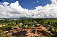
Dima Hasao district is one of the two Autonomous hill districts of the state of Assam. The district headquarter Haflong is the only hill station in Assam, a tourist paradise, also named the Switzerland of the north-east. Dima Hasao means Dimasa Hills in the Dimasa language.
Etymology
"Dima Hasao" means "Dimasa Hills" in the Dimasa language.
History
The earliest inhabitants of the present district were a Mongoloid stock of groups who prefer to stay atop hilly terrain and who practised their own culture, tradition and land rights governing themselves as independent tribes. As per records of different British historians and officials, North Cachar Hills was already occupied by the Dimasa Kacharis, erstwhile old Kuki tribes viz.Biate, Hmar, Hrangkhol, Sakachep and Zeme Naga tribe during the British Raj.[2]
During the medieval period (1500–1854), Dima Hasao was part of the Dimasa Kachari Kingdom called 'Cachar Kingdom' with its capital at Maibang. The Dimasa Kingdom as per Ahom Buranjee, stretched from Kallang river in Nagaon to Kapili river[3] that includes, parts from Cachar and North Cachar (Dima Hasao), the districts of Hojai, Nagaon, Golaghat and Karbi Anglong of Assam and Dimapur district, in Nagaland.
In the colonial period, Khaspur in present-day Cachar district, had been administrative centre. However internal schism led to division of old Cachar Kingdom into North Kachar and South Kachar. The last Dimasa king Govinda Chandra Hasnusa assigned Kashi Chandra the hilly tract of Cachar i.e. roughly Dima Hasao (North Kachar Kingdom) for administrative purpose. Soonerthe latter declared its independence over the hilly portion that lead to treacherous murder of Kashi Chandra by Raja Govinda Chandra Hasnusa. Incensed, the son of Kashi Chandra, Tularam incessantly created political turbulence asserting his sovereignty over hilly portion of Cachar Kingdom. Finally, with British assistance, Tularam succeeded in carving North Cachar Hills from Cachar Kingdom. David Scott agent to British Raj in 1829[4] made an arrangement to recognise Tularam as the ruler of North Cachar (Dima Hasao). In 1850s, Tularam died and the frequent Angami raids and grave incident at Semkhor village paved a ground to extend British influence over North Cachar. In 1853, North Cachar was annexed and made part of Nagaon district of British Assam as subdivision.
In 1867, this sub-division was abolished and apportioned into three parts among the Cachar, Khasi and Jaintia Hills districts, and Nagaon. The present Dima Hasao district, or formerly North Cachar Hills district was included in the old Cachar district with Asalu being only police outpost. In 1880, this portion was constituted into a sub-division with headquarters at Gunjung under Cachar district.
This headquarters was shifted to Haflong in 1895. Since then, Haflong has continued to be the headquarters. In 1951, after the adoption of the Indian constitution, North Cachar Hills ceased to be a part of Cachar district, as specified under paragraph 20 of the sixth schedule to the constitution. This part along with Mikir Hills constituted a new civil district named "United District of North Cachar and Mikir Hills", which went into effect on 17 November 1951. According to a provision of the sixth schedule, two different councils were constituted later on, viz., North Cachar Hills District Council and Mikir Hills District Council within the geographical boundary of that North Cachar Hills District Council was inaugurated on 19 April 1952.
On 2 February 1970, the government declared an independent administrative district, viz., North Cachar Hills District with the geographical boundary of autonomous North Cachar Hills district council. At present, this autonomous council possesses administrative control over almost all departments of the district except law and order, administration, and the treasury department.
Administration
Dima Hasao comprises three subdivisions: (I) Haflong, (II) Maibang and (III) Diyungbra. The district consists of five Community Development Blocks: (I) Jatinga Valley Development Block, Mahur; (II) Diyung Valley Development Block, Maibang; (III) Harangajao ITD Block, Harangajao; (IV) Diyungbra ITD Block, Diyungmukh; and (V) New Sangbar Development Block, Sangbar.[5] There is one municipality board viz. Haflong and three town committees in Dima Hasao viz. Mahur, Maibang and Umrangso and also mini-towns like Harangajao, Langting and Diyungbra.
Geography
The district headquarters are located at Haflong. Dima Hasao district occupies an area of 4,888 square kilometres (1,887 sq mi).,[6] comparatively equivalent to Brazil's Ilha Grande do Gurupá.[7] It is the second largest district of Assam with 4888 km2 after Karbi Anglong. Dima Hasao District is surrounded by Karbi Anglong district (E) and Nagaland on North-east, Manipur on East, Hojai District on North, Karbi Anglong Dist(W) on North-west, Meghalaya on West and Cachar district on South.
Politics
Dima Hasao district is an autonomous district enjoying the Sixth Schedule status granted by the Constitution of India. The Dima Hasao District is administered by Dima Hasao Autonomous District Council (DHADC). Members of the Autonomous Council (MAC) are elected by people of Dima Hasao. The Political party who has majority MACs form the ruling party. The Autonomous Council is a powerful body and almost all the department of government are under its control except the police and Law & Order is under Assam Government.
Economy
In 2006, the Indian government named Dima Hasao one of the country's 250 most backward districts (out of a total of 640).[8] It is one of the eleven districts in Assam currently receiving funds from the Backward Regions Grant Fund Programme (BRGF).[8]
Energy
- Kopili HEP
Kopili Hydro Electric Project is a power project near Umrangso, involving two dams on Kopili river and Umrong nalla, a tributary of Kopili. There are two power stations as part of Kopili HEP, Khandong Stage I & II (75 MW) and Kopili Stage I & II (200 MW), with total output of 275 MW.[9]
Cement
Vinay Cements was established by Mr Bawri in 1989, one of the first manufacturing units set up in the district. Since then, the region attracted a host of manufacturing units including NECEM, RCL Cements and Calcom Cement India Limited.
The then Vinay cement is now replaced by Dalmia cement, where now raw cement are made for further proccessing and exported for production.
Demographics
| Historical population | ||
|---|---|---|
| Year | Pop. | ±% p.a. |
| 1901 | 40,812 | — |
| 1911 | 27,296 | −3.94% |
| 1921 | 28,913 | +0.58% |
| 1931 | 32,844 | +1.28% |
| 1941 | 37,361 | +1.30% |
| 1951 | 39,663 | +0.60% |
| 1961 | 54,319 | +3.19% |
| 1971 | 76,047 | +3.42% |
| 1991 | 150,801 | +3.48% |
| 2001 | 188,079 | +2.23% |
| 2011 | 214,102 | +1.30% |
| source:[10] | ||
Population
According to the 2011 census, Dima Hasao has a population of 214,102,[1] roughly equal to the nation of Samoa.[11] This gives it a ranking of 588th in India (out of a total of 640).[1] The district has a population density of 44 inhabitants per square kilometre (110/sq mi).[1] Its population growth rate over the decade 2001-2011 was 13.53%.[1] Dima Hasao has a sex ratio of 931 females for every 1000 males[1] and a literacy rate of 78.99%.[1]
Ethnic groups
The major indigenous communities inhabiting the district are Dimasa Kachari, Karbi, Zeme Naga, Kuki, Hmar, Biate and a number of minor indigenous communities which includes Bodo Kachari, Hrangkhol, Khasi-Pnars, Rongmei Naga, Khelma and Vaiphei. The Kuki, Hmar, Biate, Hrangkhol and Vaiphei belong to the Kuki- Chin -Mizo or Zo- ethnic group. Non-indigenous communities includes Bengali, Gorkha tribes, Deshwali tribes and few other communities who have made the district their home.
During 2001-11 period, the population growth for the district was 13.53%, with tribals showing 18.23% growth and non-tribals showing 3.41% growth. All the major tribes had growth rates more or less equal to the district growth rate (Dima: +14.83%, Kuki:+23.70%, Khasi: +17.90%, Karbi: +16.59%, Naga: +21.98%). The religious composition within the major ethnic groups have remained remarkably stable, with only the Karbis showing a noticeable change.
As per the language data, the largest non-tribal communities are Bengalis (25,264 : change of -7.53% from 2001), Nepalis (13,615 : +9.76%), Hindi speakers (9,926 : +13.83%), Assamese speakers (4,057 : -26.32%), Halam-Kuki/Khelma/Riam (1,940 : +15.41%), Bodo-Kachari (1,604 : -7.82%), Meitei (1,373 : -24.64%), Tripuri (527: -21.11%), and Bishnupriya (401: -14.32%).[12]
| Ethnic Group | Y 2011[13] | Y 2001[14] | Religion Y 2011 | Religion Y 2001 |
|---|---|---|---|---|
| Total | 214,102 | 188,079 | Hindu - 67.07% | Hindu - 69.91% |
| Dimasa | 74,502 | 64,881 | Hindu - 99.19% | Hindu - 98.73% |
| Hmar | 15,070 | 13,863 | Christian - 99.18% | Christian - 98.71% |
| Khasi | 3,722 | 3,157 | Christian - 96.94% | Christian - 95.31% |
| Kuki | 24,079 | 16,757 | Christian - 93.17%, Hindu - 6.03% | Christian - 91.98%, Hindu - 7.56% |
| Karbi | 9,296 | 7,973 | Hindu - 50.77%, Christian - 48.69% | Hindu - 63.18%, Christian - 36.52% |
| Naga | 20,832 | 17,078 | Christian - 53.67%, Hindu - 40.46%, Animist - 5.14% | Christian - 52.20%, Hindu - 43.72%, Animist - 3.43% |
| Smaller tribes | 4,342 | 4,719 | Christian - 62.92%, Hindu - 34.94% | Christian - 59.00%, Hindu - 38.12% |
| Non-tribal | 61,686 | 59,651 | Hindu - 85.80%, Muslim - 6.50%, Christian - 5.57% | Hindu - 86.57%, Muslim - 7.34%, Christian - 4.57% |
Languages
Languages of Dima Hasao in 2011
Dima Hasao is one of the two hill districts in Assam which has a tribal majority population, the other being Karbi Anglong with the tribal population in Dima Hasao accounting for about 71% of the total population of the district according to the 2011 census. The major tribal languages spoken in the district are Dimasa, Zeme, Hmar, Kuki, Biate, Karbi, Hrangkhol, Khasi and Khelma.
The major non tribal languages spoken in the district are Assamese, Bengali, Nepali and Haflong Hindi (a speech form of Hindi). Haflong Hindi is the lingua franca in the Dima Hasao.[15]
Culture
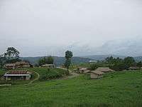
Dima Hasao District is a land of sensuousness. The district is populated of various tribes and races who maintain their own dialect, culture, customs and way of living. Apart from various tribes, non-tribals also account for a sizable amount of the population. They are mostly government employees, traders, graziers living in urban and semi-urban area. The small and serene villages shelter the lovely people – warm and fascinating – and as colourful as the land itself.
Dimasa Kacharis
The Kacharis are the most widely spread tribe in northeast India. They are said to be the earliest inhabitants of the Brahmaputra Valley. The Kacharis belong to the Indo-Mongoloid (Kirata Family) group which include the Bodo Kacharis and their allied tribes like Garo, Sonowal Kachari, etc. They have prominent Mongoloid features with high cheek bones, slit eyes and a slight growth of hair in the body and scant beard. They call themselves Bodo or Bodo-fisa in the Brahmaputra Valley (Dilao Dibu) and Dimasa or Dima-basa or ‘sons of the great river’ in Dima Hasao & Karbi- Anglong district. Dimasas are known as Kachari in Nagaland, Hojai Kachari in Hojai district, Kampuri Kachari in Kampur region of Nagaon district, Barman Kachari in Barak Valley and also Rukkini Barman.
The Dimasa Kacharis greatly inhabit the northern half of the Dima Hasao District and ravines of the Jatinga valley and the adjoining areas. The Dimasas believe in the existence of a supreme being Madai – Under whom there are several Madais including family deities and evil spirits. The religious practices of the Dimasas are reflected in their Daikho system. A Daikho has a presiding deity with a definite territorial jurisdiction and a distinct group of followers known as Khel. Every Dimasa Kachari family worships its ancestral deity once a year before sowing the next paddy. It is known as Madai Khelimba. This is done for the general welfare of the family. And Misengba is for the good of the whole community. They cremate their dead. The dead body is washed and dressed in new clothes, the corpse is placed inside the house on a mat. A fowl is thrashed to death and placed at the foot of the deceased so that it might show the deceased the right path to heaven. The widow does not tie their hair till cremation. The dead body is cremated by the side of a river or stream.
The Dimasa have a tendency to build their houses on hill slopes with a river or streamlet flowing nearby. The dwelling houses are built on plinth of earth – in two rows facing each other with a sufficiently wide gap in between.
An important institution of the village is Hangsao. It is an association of unmarried boys and girls of the village. It is organized for the purpose of working together in cultivation and lasts only for one year. Throughout the year, the members of the Hangsao work together in the Jhums cultivating by rotation an area of land at every member's field.
Music and dance play an important role in the day-to-day life of the Dimasa Kacharis. They sing and dance expressing their joy at the youth common houses ‘Nadrang’ or at the courtyard of the ‘Gajaibaou’s house in popular common festival like Bushu or Hangsao – manauba. The female owner of the house, where the Bushu festival is held, is called ‘Gajaibaou’.
By using their traditional musical instruments like Muri, Muri-wathisa, Supin Khram, Khramdubung, they present their traditional dances named – Baidima, Jaubani, Jaupinbani, Rennginbani, Baichargi, Kunlubani, Daislelaibani, Kamauthaikim Kaubani, Nanabairibani, Baururnjla, Kailaibani, Homaudaobani, Rongjaobani, Dausipamaikabani, Daudngjang, Nowaijang, Dailaibani, Narimbani, Rogidaw bihimaiyadaw, Maijaobani, Maisubanai, Richibbani, Michai bonthai jibnai, Homojing ladaibani, Berma charao paibani, Mangusha bondaibani, Madaikalimbani etc.
The males put on the traditional dresses like richa, rikaosa, paguri rimchau and rimchaoramai to perform the folk dances. The females put on Rigu, riijamphain,rijamphain-beren, rikhaosha, rikhra, jingsudu etc. and wear ornaments like Khadu-dima, Khadu, Khmauthai, Longbar, Panlaubar. Chandrawal, Rangbarsa, Enggrasa, Jongsama, Ligjao, Jingbri, Yaosidam etc.
The dance forms of the Dimasa Kacharis are complex in character. They are strictly dependent on instrumental music. No songs are used. Khram (drum) follows the rhythm of the Muri (fife) and so also the dancers. Though one may find the music trilling from Muri to be monotonous, but there are variations with noticeable microtones for different dance forms. That is why young men practice dancing at Nadrang during leisure hours and the village children follow the rhythm and stepping at a distance from an early age.
Zeme Nagas
The Zemes are distributed in the southern region of Dima Hasao. They are classified by the anthropologists as one of the sub-tribes of the Kacha Nagas. The Zemes living in Nagaland call themselves Zeliang and those of the Manipur borders are known as Zeliangrong.
Originally they migrated from Nagaland via Manipur and settled down in the north-eastern part of N.C. Hills and south of Maibang, the ancient capital of the Kachari kings. They also settled as far as the bank of the river Kopili. With the decline of the Kachari power, the Zemes became easy victims of the depredations of the mighty Angami Nagas in the neighbourhood. As a result, some of the Zemes migrated to the west and settled in the hills beyond the Diyung valley. They speak their own Zeme dialect and are living peacefully along with the other tribes like Dimasa Kachari, Kuki, Hmar for more than two centuries. The Zemes are well built, strong ang healthy with thick black hair and a fair complexion.
The Zeme villages are on the breezy hill-tops. Each village has dormitories for young boys and girls. The boys’ dormitories are called Hangseuki and the girls’ are known as Leuseuki. All the young unmarried boys and girls spend the night in their respective dormitories. As soon as one is married he or she ceases to be a member of the dormitory which are considered as centers of learning as well as village recreational activities. The girls are taught weaving, spinning, singing and dancing etc. and the boys are taught wrestling, hunting and making of handicrafts. These dormitories also serve as guest houses.
Though a small section of the Zemes have been converted to Christianity, the larger section still honour their traditional festivals connected with agricultural activities and other social institutions. They celebrate some six important festivals during the year.
Youth dormitories play an important role in celebrating their festivals. The main festivals are – Helei-bambe, Nchang-bambe, Pokpat-ngi, Engkamngi, Siami and Hega-ngi – mostly connected with agricultural activities.
Of the folk dances of the Zemes the popular ones are – Herepilim, Johumpeselim, Kan'guibelim, Kerapsaplim, Hakalim, Nbzchuinelim etc.
In their songs and dance performances they use their traditional musical instruments – 'Nsum, Ntoi, Metiam, Hemeu, 'Nra, Kebuike etc.
The Zeme traditional male dresses are named as Heni, Njingni, Heteuba, Mpakphai, Peranphai, Lauhepai, etc. The young boys decorate their legs with rice powder paste and tie cane ropes just below the knee. The girls wear Mini Hegiangnine, Paimang, Paitik, Pilim etc. and ornaments made of silver, brass and colourful bird feathers for the earlobes.
Hmars
The Hmars are of Mongoloid stock. Though the tribe is divided into exogamous clans but they do not strictly adhere to exogamy. Monogamy is strictly followed. Arranged cum Love-Marriages are preferred.
The system of bride price is still prevalent, and the youngest daughter usually gets an extra price called 'Nuzum'. Earlier they practiced animism, and their God was "Pathien", and sacrifices were offered for his appeasement. Now almost the whole of the tribe is converted into Christianity, and they have built churches in their villages, and religious rites are performed according to the tenets of Christianity. The Hmars built their villages on hilltops, and houses are constructed on wooden planks. Slash-and-burn system of agricultural practices is still at large amongst the Hmars.
Even after long years of migration from their original abode, the Hmars still adhere to their traditional culture through observing their traditional festivals connecting with agricultural cycle and other community rites and practices. Their cultural traditions are best reflected in their folk songs and dances. Khuong (drum) is the main part of the musical instrument. The other musical instruments are Pheiphit (whistle made of bamboo), Theihle (bamboo flute), Darkhuong (gong), Darbu (set of small gong), Darmang (flat brass gong), Seki (set of mithun horn), Hna Mut (Leaf instrument), Perkhuong (guitar made of bamboo) etc.
According to the Hmar genealogy, the following are the major clans. They are Lawitlang, Hrangchal, Hrangate, Zote, Lungtau, Khawbung, Pakhuong, Vankal, Khelte, Hrangate, Khawzawl, Hekte, Kawlni, Tuahlawr,Selate, Sialhnam, Suamte, Pakhumate, Rualngul, Faiheng, Rawite, Zawngte, Punte, Sanate, Sinate, Buangpui, Siakeng, Hrangngulte, Khuangpui, Lelhchhun, Khupthang,Khupchhung, Tumchhung Khawral, Saihmar, Saivate, Tusing, Sekong, Seitling, Tuimoul, Arte, Thlanghnung, Bapui, Tuollai, Hmuntha, Khawkieng, Khello, Chhinghel, Leiri, Ngurte, Khiengte, Pautu, Khuolhring, Hmar Lusei, Changsan, Ngenzo, Neilut, Ngente, Milai, Nelriam, Thlaute, Sim, Khawhreng, Khawthlang, khawzawl, Amo, Varte.
The chief of their village council is called "LAL". He is selected from amongst the youngest son except Leiri and Faihriem Clans. He is all-powerful and everybody follows his leadership and directive.
The Hmar womenfolk are great weavers in their tiny loin looms. They dye their homespun yarns into different colours and weave exquisite clothes for the family. Man and women wear different kind of clothes. Hmar – am is finely woven cloth for the aristocratic womenfolk, Tawn lo – puon is a breast cloth never to be touched by a man, Tharlaikawn is a body wrapper with coloured strips on the back for the women. Ngo – tlawng is a white wrapper for women, Thangsuo – Puon is for the great hunters and heroes who have earned the title ‘Thangsuo" for valour, Rukrak – puon is a long wrapper for village aristocrats, Hmar – puon is a common cloth with black and white strips, Daraki is a dhoti for the malefolk, Paihar is a chaddar for men, Lukawm is a soft cloth for man's headgear, Poundum is a chaddar for menfolk and Puon – Kernei is the finely woven breast wrapper for the village maidens.
The festival highlighting agricultural practices is Sikpui Ruoi and Butukhuonglawm. They express their happiness in Dar lam and Parton lam dances by rhythmic beating of the drums. To honour a great hunter they perform Pheiphitlam dance accompanied by melodious tune trilling from their flutes. To perform Fahrel Tawk lam, they use bamboo poles like the Lusei (in their famous Cheraw dance).
The Hmars perform a number of dances –the Harvest dance is called Chawn lam, the hunting dance is known as Salu lam and a privately organized festival dance is popular as Thangkawngvailak. The dancers, both boys and girls, put on their colourful traditional dresses and the boys wear headgear Tawnlairang made of bird's feathers or Lukhum made of bamboo, and the colourful shawl called Hmar puon. The girls adorn themselves with ornaments like Kutsabi (rings), Banbun (bangles), Nabe (earrings), Thi (Seeded Necklace), Thi val (beaded ornaments), Thi hna (beaded ornaments) etc., and wear exquisitely embroidered Puons, Puonbil and Zakuo. They rejoice in drinking ‘ Zu’ (rice beer) and the oldman and woman smoke in their ‘Tuibur’ pipes at their hearts content.
The Hmars are great hunters and while returning with precious games, they dance ‘Salu lam’ to mark their victory.
The Hmars love dancing so much that the very thought of the dance arena brings out the dancers in them. And they dance ‘Chawn lam’ while proceeding to the arena.
Leiri Village in Jinam Valley Area is the oldest Hmar Village in Dima Hasao dating back to the 17th and 18th Century.
Kukis
The term 'Kuki' is a generic term for a number of mixed group of people who have migrated into India through Burma from central Asia. In Burma they are called Chin, and in Indian frontier states they are best identified as Kukis.
The Ministry of Home Affairs, Govt. of India lists 37 number of tribes which are under the Kuki community in Assam.
- Baite or Biete
- Changsan
- Chongloi
- Doungel
- Gamlhou
- Gangte
- Guite
- Hangsing
- Haokip or Haupit
- Haolai
- Hauzel
- Kullai
- Munvung
- Hengna
- Hangsing
- Hrangkhawl or Rongkhol
- Jongbe
- Khawchung
- Khwathlang
- Khuangsai
- Khelma
- Kholhou
- Kipgen
- Kuki
- Lienthang
- Lhangunm
- Lhoujem
- Lhouvum
- Lupheng
- Lutchong(Gensei & Genthang)
- Chhando
- Haucheng
- Lawisei
- Mangjol
- Misao
- Riang
- Sairhem
- Selnam
- Singson
- Sitlhou
- Sukte
- Thado
- Thangew
- Uibuh
- Vaiphei
Being of mongoloid stock the Kukis are strongly built in features and are stout. They are patriarchal in social organization and the sons inherit the property. Marriage among the Kukis are monogamous and cross-cousin marriage is preferred.
The Kukis prefer to live on the hill tops and their villages are cluster of houses closely constructed to protect from alien raiders. The village headman wields considerable power in their day-to-day life affairs. The headman is assisted by some wise man called Siemang and Pachong and all household heads of the village congregate to discuss and resolve matters relating to the village and the community. Though Christianity has brought considerable changes in their socio-economic life, yet the Kukis still adhere to much of their old customs, laws and habits which their illustrious forefathers adopted from time immemorial.
The Kukis grow dwarf cotton and spun yarns for their own use. They use vegetable dyes in a myriad of hues and weave dreamlike designs mostly geometric in nature. The menfolk prefer colourful Sangkhol, a jacket and a pheichawm (short lungi or dhoti) and wrap a chaddar which is sometimes embroidered like a snake skin. They also wear head dresses viz., tuhpah, delkop.
The women adorn themselves with a nih-san (red slip) underneath a pon've (a wrap around) which was worn from above the chest. The ornaments included bilba (earrings), hah-le-chao (bracelets and bangles), khi(necklace) and occasionally bilkam (a type of ring shaped earring to stretch the ear lobe). They split their tresses into two and wrap them over their heads into fine knots.
Both men and women enjoy smoking from their intricately crafted pipes named differently. Those made from stones and brass-metal are Sumeng golong, only made from brass-metal are Sum thin golong and those carved out of wood with a brass spout are called Gojung golong.
After the harvest is over, the Kukis observe the Chavang kut festival at the country-yard of the village headman. They perform traditional dances like Jongchalam, Malkanglam etc. to the tune of their traditional musical instruments – Khuong, Dahbo, Pheipit, Gosem, Dah-pi, Dah-cha, Pengkul, Theile, Theiphit, Selki etc. Other festivals are Mim Kut, Sa-ai, Chang-Ai, Hun, Chawn le Han etc.
The participating families wear their traditional dresses Sangkhol, Khamtang, Ponmonvom, Saipikhup and the malefolk adorn with Sangkhol, Delkop etc.
The harvest season is always a time for festivities, dancing and singing. The Kukis express the farmer's happiness in Jongchalam by body breaks and rhythmic steps. And when the days of hard toil in their jhum fields are over, the Kukis rejoice while dancing Malkanglam.
Sagolpheikhal is a dance to express victory in war or in successful group hunting.
Biates
The Biate people are one of the oldest hill tribes of India. They were the first to settle in present-day Mizoram, from where they were pushed by later immigrants further north to other parts of North Eastern India. Today, the Biates are found in all the states of North east India except Arunachal Pradesh.
The Biates have their own dialect and cultural traits which are expressed through many festivals in different occasions. Among them the agricultural festivals like Nûlding Kût, Favang Kût, Ringmuthar Kût, Cemchoi Kût, Pamchar Kût are important. Jolsuak and Salu lâm are observed to honour the brave hunters of ferocious animals.
During the festive days they consume liberal quantities of Zu rice beer while dancing and singing their traditional dances like Buantum-lâm, Kolrikhe-lâm, Rikifacho-lâm, Parton-lâm, Sulribum-lâm, Thingpuilethluk-lâm, Mebur-lâm and Dar-lâm in tune with their musical instruments named Dar-ribu, Jamluang, Khuang etc.
Both the boys and girls wear their traditional dresses and ornaments during performance of these dances. The girls put a decorated cane ring as a head gear and drape their favourite Jakua, Choipuan, Puanbomzia etc. The boys wear Lu kôm, Zakua, Diarkai etc. The girls ornaments include Rithei, Kuarbet, Banbun, Ritai etc.
On the first day of broadcasting seeds in their jhum fields, the Biate women perform Mebûr lâm dance to please ‘Bu pathian’, their god for crops and bounty. They dance with bamboo tubes in their hands and touch each other in a rhythmic way.
After they return from the fields the women sometimes gather in a courtyard and perform Rikifachoi lâm, imitating the wild parrots pecking grains from their jhum fields.
In winter, almost all Biate women go to a nearby stream or riverlet and dance Tuipuilen thluk in praise of the legendary mermaids. They break their bodies like waves in an ocean in tune with the accompanying flute.
Hrangkhol
Differently described by the ethenographers as Hrangkawal, Rongkhol or Hrongkhol, this tiny group of people of the great Kuki tribe is scatteredly thriving in the Dima Hasao District. Mainly agriculturists, they practice jhum cultivation and build their houses on wooden slit and use bamboo profusely for the floor as well as the walls and thatch for the roofs.
The womenfolk use puans dyed in black and relish smoking from tiny but elaborate smoking pipes like those used by the Mizos of the southern districts.
The Hrangkhols observe the harvest festival called Rual-Safak and invite the spring season through Parangat festival.
‘Parangat’ means flower. When the spring comes, flowers bloom everywhere. The Hrangkhols observe Parangat on a full moon day. The festival begins in the evening and continues till next morning. Except the main entry to the village, all other paths are closed for the day. The young men collect wild flowers from the nearby forest and offer them to the oldest man of the village in a decorated basket. And thereafter they greet each other and welcome the advent of spring. They sing and dance the whole night with drinking bouts of rice-beer in the silvery moonlight.
Like other hill tribes, fish is a symbol of prosperity to the Hrangkhol. They imitate community fishing in their Soksolkirlam dance. It is a rhythmic expression of their prayer for health and happiness.
The Hrangkhols present a special dance ‘Bhailam’ to welcome honourable persons into the village. The male dancers wear Churia, Kamis, Lukom, Changkaltak and the female participants wear Ponbomtak, Ponamnei, Kongkhit, Thepbop etc. They use ornaments called Jakcher, Chumhrui, Lirthei etc.
In these festivals the performance of songs and dance are the main attractive items. They participate in their folk dances known as Darlam, Doinkini, Rochemiam and Soksollam. They play on their traditional musical instruments like Dar, Cheranda, Rochem, Theile etc.
Education
Average literacy rate of Dima Hasao in 2011 were 77.54 compared to 67.62 of 2001. All schools of Dima Hasao are run either by the state government or by private organisations. Mostly English is the primary languages of instruction in most of the schools. The schools are recognized to Board of Secondary Education, Assam (SEBA), Assam Higher Secondary Education Council (AHSEC ) And Central Board Of Secondary Education(CBSE).All Colleges of Dima Hasao are affiliated to Assam University, a central university, which imparts education in both the general as well as professional streams. The university, which came into existence in 1994, has 16 schools and 35 post-graduate departments under them. The university has 51 affiliated colleges under it.
College
- Haflong Government College, Haflong
- J.B Hagjer Junior College, Umrangso
- B. Bodo Junior College, Maibang
- Hills Degree College, Haflong
- J.B Hagjer Memorial Junior College, Diyungbra
- Maibang Degree College, Maibang
- Sengya Sambudhan Junior College, Haflong
- M.C.D Junior College, Harangajao.
Schools
Prominent schools in the district:
- Vivekananda Kendra Vidyalaya,NEEPCO, Umrangso
- Don Bosco Higher Secondary School, Haflong
- Trinity High School, Mahur
- Vivekananda Kendriya Vidyalaya, Sarkari Bagan, Haflong
- Mahur High School, Mahur
- St. Agnes Convent Higher Secondary School, Dibarai, Haflong
- Jawahar Navodaya Vidyalaya, Haflong
- CHT Synod Higher Secondary School, Haflong
- Tularam Memorial Good Shepherd School, Gunjung
- Presbyterian High School, Mahur
- Langting High School, Langting
- HM St. Mary's High School, Langting
- Prabananda Vidya Mandir, Maibang
- Ever Green High School, Maibang
- Raja Gobindh Chandra Aarsh Gurukulum, Diyungbra
- Royal Academy, Umrangso
- Jamundadevi Saraswati School
- Sacred Heart high school, umrongso
Media
Television
| Channel | Year founded | Language | Owned by | Ref |
|---|---|---|---|---|
| NDH (News Dima Hasao) | Dimasa/Hindi/English/ | Zed Nunisa | ||
| Assam Talks | Assamese | Mahmadhul Hussan | ||
| News Live | Assamese | Ashim Choudhury | ||
| News Time Assam | Assamese | Anup Biswas | ||
| Prag News | Assamese | Sanjib Dutta | ||
| DY365 | Assamese | Samsul Alam | ||
| NEWS18 | English, Assamese | Pankaj Kumar Deb | ||
| Hills Live TV |
Borail News
Radio
- All India Radio, Akashvani Haflong broadcasts from Haflong at 100.02 megahartz on FM band.
Local newspapers
- Haflong Khurang (Dimasa weekly)
- 'Haflong Times (English weekly)
- Dima Hasao Post (English weekly)
- Agape (Hmar weekly)
See also
References
- "District Census 2011". Census2011.co.in. 2011. Retrieved 30 September 2011.
- Stewart, Lieutenant R. "Notes on Northern Cachar (1855).
- Gait, Edward. (2011) History of Assam: Surjeet Publication. Delhi.
- Rhodes, NG & Bose, SK. (2006) History of the Dimasa -Kachari As seen Through the coinage. Mira Bose: Dhubri (Assam).
- "Dima Hasao District". North Cachar Hills. Retrieved 19 September 2018.
- Srivastava, Dayawanti et al. (ed.) (2010). "States and Union Territories: Assam: Government". India 2010: A Reference Annual (54th ed.). New Delhi, India: Additional Director General, Publications Division, Ministry of Information and Broadcasting (India), Government of India. p. 1116. ISBN 978-81-230-1617-7.CS1 maint: extra text: authors list (link)
- "Island Directory Tables: Islands by Land Area". United Nations Environment Program. 18 February 1998. Retrieved 11 October 2011.
Ilha Grande do Gurupá 4,864km2
- Ministry of Panchayati Raj (8 September 2009). "A Note on the Backward Regions Grant Fund Programme" (PDF). National Institute of Rural Development. Archived from the original (PDF) on 5 April 2012. Retrieved 27 September 2011.
- "Kopili Hydro Electric Project". Water Resources Information System of India. Retrieved 23 February 2019.
- Decadal Variation In Population Since 1901
- US Directorate of Intelligence. "Country Comparison:Population". Retrieved 1 October 2011.
Samoa 193,161
- http://www.censusindia.gov.in/2011census/C-16.html
- http://www.censusindia.gov.in/2011census/SCST-Series/ST14.html
- http://www.censusindia.gov.in/DigitalLibrary/MFTableSeries.aspx
- Col Ved Prakash, "Encyclopaedia of North-east India, Vol# 2", Atlantic Publishers & Distributors;Pg 575, ISBN 978-81-269-0704-5
External links
| Wikivoyage has a travel guide for Dima Hasao. |
Places adjacent to Dima Hasao district | ||||||||||
|---|---|---|---|---|---|---|---|---|---|---|
| ||||||||||