Jalaun district
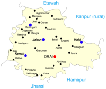
Jalaun district is a district of Uttar Pradesh, India. The district is named after the town of Jalaun, which was the former headquarters of a Maratha governor, but the administrative headquarters of the district is at Orai. Other large towns in the district are Konch, Kalpi, and Madhogarh.
Jalaun district | |
|---|---|
District of Uttar Pradesh | |
 Location of Jalaun district in Uttar Pradesh | |
| Country | India |
| State | Uttar Pradesh |
| Division | Jhansi |
| Headquarters | Orai |
| Tehsils | 5 |
| Government | |
| • Lok Sabha constituencies | Jalaun (Lok Sabha constituency) |
| • Vidhan Sabha constituencies | 4 |
| Area | |
| • Total | 4,565 km2 (1,763 sq mi) |
| Population (2011) | |
| • Total | 1,689,974 |
| • Density | 370/km2 (960/sq mi) |
| Time zone | UTC+05:30 (IST) |
| Major highways | 1 |
| Website | http://jalaun.nic.in/ |
Geography
Jalaun District is a part of Jhansi Division. The district has an area of 4,565 km², and a population of 1,689,974 (2011 census), with a population density of 370 persons per km².
The district lies entirely within the level plains of Bundelkhand, north of the hill country, and is almost surrounded by the Yamuna River, which forms the northern boundary of the district, and its tributaries the Betwa, which forms the southern boundary of the district, and the Pahuj, which forms the western boundary. The central region thus enclosed is a dead level of cultivated land, almost destitute of trees, and dotted with villages. The southern portion presents an almost unbroken sheet of cultivation. The Non River flows through the centre of the district, which it drains by innumerable small ravines.[1]
The districts of Etawah and Kanpur lie to the north across the Yamuna, while Hamirpur District lies to the east and southeast, Jhansi District lies to the southeast, and Bhind District of Madhya Pradesh lies to the west cross the Pahuj.
The district has been under severe drought for the last four years with the average rainfall being about 399 mm which is way behind the average of about 800 mm.
Economy
In 2006 the Ministry of Panchayati Raj named Jalaun one of the country's 250 most backward districts (out of a total of 640).[2] It is one of the 34 districts in Uttar Pradesh currently receiving funds from the Backward Regions Grant Fund Programme (BRGF).[2]
Demographics
According to the 2011 census Jalaun district has a population of 1,689,974,[3] roughly equal to the nation of Guinea-Bissau[4] or the US state of Idaho.[5] This gives it a ranking of 296th in India (out of a total of 640).[3] The district has a population density of 366 inhabitants per square kilometre (950/sq mi) .[3] Its population growth rate over the decade 2001–2011 was 14.87%.[3] Jalaun has a sex ratio of 865 females for every 1000 males,[3] and a literacy rate of 75.16%.[3] Largest city in the district is Orai, followed by Konch as per report released by Census, 2011.
At the time of the 2011 Census of India, 98.66% of the population in the district spoke Hindi and 1.30% Urdu as their first language.[6]
| Historical population | ||
|---|---|---|
| Year | Pop. | ±% p.a. |
| 1901 | 424,017 | — |
| 1911 | 431,158 | +0.17% |
| 1921 | 431,164 | +0.00% |
| 1931 | 452,074 | +0.47% |
| 1941 | 515,476 | +1.32% |
| 1951 | 553,572 | +0.72% |
| 1961 | 663,168 | +1.82% |
| 1971 | 813,490 | +2.06% |
| 1981 | 986,238 | +1.94% |
| 1991 | 1,219,377 | +2.14% |
| 2001 | 1,454,452 | +1.78% |
| 2011 | 1,689,974 | +1.51% |
| source:[7] | ||
Gallery
 Agricultural fields in Jalaun District in U.P.
 Lalpur railway station which lies in Jalaun District is on the Jhansi-Kanpur main railway line
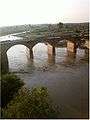 A river flowing through the Jalaun District in U.P.
Medical College
- Government Medical College, Jalaun is a government medical college located in Orai of Jalaun district.
See also
References
-

- Ministry of Panchayati Raj (8 September 2009). "A Note on the Backward Regions Grant Fund Programme" (PDF). National Institute of Rural Development. Archived from the original (PDF) on 5 April 2012. Retrieved 27 September 2011.
- "District Census 2011". Census2011.co.in. 2011. Retrieved 30 September 2011.
- US Directorate of Intelligence. "Country Comparison:Population". Retrieved 1 October 2011.
Guinea-Bissau 1,596,677 July 2011 est.
- "2010 Resident Population Data". U. S. Census Bureau. Archived from the original on 19 October 2013. Retrieved 30 September 2011.
Idaho 1,567,582
- 2011 Census of India, Population By Mother Tongue
- Decadal Variation In Population Since 1901
External links
| Wikimedia Commons has media related to Jalaun district. |
Places adjacent to Jalaun district | ||||||||||
|---|---|---|---|---|---|---|---|---|---|---|
| ||||||||||