Wayanad district
Wayanad is an Indian district in the north-east of Kerala state with administrative headquarters at the municipality of Kalpetta. It is set high on the Western Ghats with altitudes ranging from 700 to 2100 meters.[4] The district was formed on 1 November 1980 as the 12th district in Kerala by carving out areas from Kozhikode and Kannur districts. About 885.92 sq.km of area of the district is under forest.[5] Wayanad has three municipal towns—Kalpetta, Mananthavady and Sulthan Bathery. There are many indigenous tribals in this area.[6][7]
Wayanad district | |
|---|---|
 .JPG)  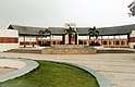   Clockwise from top: Chembra Peak, Wayanad Wildlife Sanctuary, Mall at Sulthan Bathery, Paddy fields, Entrance of Karapuzha Dam, Edakkal Caves | |
| Etymology: Vayal Nadu: land of paddy fields[1] | |
| Motto(s): "Way Beyond"[2] | |
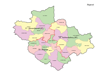
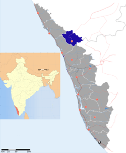 Location of Wayanad district in Kerala | |
| Coordinates: 11.633090°N 76.089638°E | |
| Country | |
| State | Kerala |
| District Formation | 1980 November 1 |
| Headquarters | Kalpetta |
| Government | |
| • Member of parliament (India) | Rahul Gandhi |
| • District Collector | Adeela Abdulla IAS |
| • District Panchayat President | K B NASEEMA |
| • District MLAs | Sultan Bathery: I.C. Balakrishnan Kalpetta: C.K. Saseendran Mananthavady: O.R. Kelu |
| Area | |
| • Total | 2,132 km2 (823 sq mi) |
| Highest elevation | 2,100 m (6,900 ft) |
| Lowest elevation | 700 m (2,300 ft) |
| Population (2011)[3] | |
| • Total | 817,420 |
| • Density | 380/km2 (990/sq mi) |
| Time zone | UTC+05:30 (IST) |
| STD Code | 4936, 4935 |
| ISO 3166 code | IN-KL |
| Vehicle registration | KL-12 Kalpetta, KL-72 Mananthavady, KL-73 Sultan Bathery |
| Website | wayanad |
Wayanad district is bordered by Karnataka to north and north-east, Tamil Nadu to south-east, Malappuram to south, Kozhikode to south-west and Kannur to north-west.[8] Pulpally in Wayanad boasts of the only Lava- Kusha temple in Kerala and Vythiri has the only mirror temple in Kerala which is a Jain temple. The edicts and caves of Ambukuthi Mala and another evidence state that the place is as old as the beginning of the New Age Civilisation.[9]
Etymology
The name 'Wayanad' is derived from 'Vayal Naatu' (Malayalam) which translates to 'the land of paddy fields' in English.[5]
History
Historians believe that the human settlements existed in these parts for at least ten centuries before Christ. Much evidence of New Stone Age civilisation can be seen in the hills throughout the present day Wayanad district. The Edakkal Caves has 6000-year-old rock engravings from the Neolithic age. The recorded history of this district is available only from the 18th century. In ancient times, this land was ruled by the Rajas of the Veda tribe.[10]
The Kutumbiyas (Kudumbiyas):
The two caves of Ampukuthimala (Edakal Caves) in Sulthan Bathery, with pictures on their walls and pictorial writings, speak volumes of a bygone civilisation. At the foot of the Edakal Male (hill) caves, Kannada inscriptions belonging to Canarese chieftain Vishnu Varma of Kutumbiya (Kudumbiya) clan of Mysore dating to c. 5th century CE were discovered which read - 'Palapulitaanamtakaari' or 'Pala pulinânam ta-kâri', Sri Vishnu Varma Kutumbiya Kulavardhanasya li..it..a..'. As per Hultzch, an epigraphist from the department of epigraphy, Madras, it speaks of the glorious descendant of Kutumbiya clan, Kannada chieftain, Vishnu Varma, as one who killed many tigers. Some scholars speculate this Kutumba clan to be the same as the Kurumbas found there.[11][12][13]
The Kadambas:
In the 11th century AD, Gangas were dethroned from Bayalnad by Kadamba dynasty[14] of North Canara.[15] Wayanad was at that time divided into two portions - Bira Bayalnad and Chagi Bayalnad. One of the Mysore inscriptions (alluding perhaps to the treacherous beauty of the country, which attracted the stranger and then laid him low with malaria) says 'an adulteress with black waving curls, as adulteress with full-moon face, an adulteress with endless side-glances, an adulteress with adorned slim figure was this storeyed mansion, the double Bayalnad'.[16] Kadamba Bayalnad emerged as a rule in the 11th century under their chief Raviyammarasa with Kirttipura in Punnad their capital. Kanthirava (1090 CE) was described as ruling Chagi-Bayalnad. Iravi-Challamma (1108 CE) was the ruler of Bira-Bayalnad.[17]
The Hoysalas:
In 1104 AD Vishnuvardhana of Hoysala invaded Bayalnad followed by Vijayanagara dynasty in the 14th century. A Kadamba king, Mukkanna-Kadamba ruled Bayal-nad in and around 1138 CE.[18]
The Vijayanagara empire:
A feudatory chieftain of Sangama dynasty of Vijaynagar, Immadi Kadamba Raya Vodeyayya of Bayalnad Kadambas, is said to have ruled Bayalnad.[17]
The Mysore Wodeyars and the Sultans:
In 1610 AD Udaiyar Raja Wadiyar of Mysore drove out Vijayanagara General and became the ruler of Bayalnad and the Nilgiris. Bayalnad is the present Wayanad. When Wayanad was under Hyder Ali's rule, the ghat road from Vythiri to Thamarassery was constructed.[19] Then the British rulers developed this route to Carter road.[20] When Wayanad was under Tipu Sultan's rule British invasion started. Tussle and turbulent times followed. The British claimed Wayanad under the 1792 treaty of Srirangapatna citing it was part of Malabar. Tipu Sultan went in appeal before the Governor General. Considering his arguments, relying on the successive Karnataka rule for centuries in Wayanad and its geographical detachment from Malabar, in 1798, Governor General Lord Mornington declared by proclamation[21] that Wayanad had not been ceded to the East India Company by the treaty of 1792. Consequently, the British troops withdrew from Wayanad conceding to Tipu's rule. In 1799, after the fall of Sultan, the British handed over Wayanad by the treaty of 1799 to the Raja of Mysore. But by a supplementary treaty dated 29 December 1803 the East India Company repossessed Wayanad and thereafter administrated by Col. Arthur Wellesley from Srirangapatna and North Wayanad came under the rule of the Pazhassi Raja dynasty of ancient Kottayam.
British Rule:
In the end, the British could get only the dead body of the Rajah, who killed himself somewhere in the interior of the forest. Thus, Wayanad fell into the hands of the British and with it came a new turn in the home of this area. The British authorities opened up the plateau to the cultivation of tea and other cash crops by constructing roads across the dangerous slopes of Wayanad, to Kozhikode and Thalassery. Later, they extended these new roads to the cities of Mysore and Ooty through Gudalur. Settlers emigrated from all parts of Kerala and the fecund lands proved a veritable goldmine with incredible yields of cash crops. Agriculture Cultivation started broadly after 1900 A.D onwards. Wayanad eventually became part of Kerala despite its geographical delimitations and political descent in 1956 on State's reorganisation. Even now there is a considerable Kannada speaking population and the reminiscence of centuries old Karnataka rule is omnipresent in Wayanad. When the State of Kerala came into being in November 1956, Wayanad was part of Kannur district. Later, south Wayanad was added to Kozhikode district. To fulfil the aspirations of the people of Wayanad for development, North Wayanad and South Wayanad were carved out and joined together to form the present district of Wayanad. This district came into being on 1 November 1980 as one the twelve districts of Kerala,[22] consisting of three taluks; Vythiri, Mananthavady, and Sulthan Bathery.
Tribes in Wayanad
The Wayanad have the largest tribal population in Kerala with 8 scheduled tribes including Adiyan, Paniyan, Mullukkurman, Kurichyan, Vettakkuruman, Wayanad Kadar, Kattuniakkan and Thachaanadan Mooppan. These communities have a number of symbolic oral narratives[23]
Adiyan: Adiyans are a matrilineal Tribal group, who were treated as bonded slave labourers by the landlords up to 1976. Now majority of them are agricultural labourers and some of them are marginal agriculturalist. They spoke Adiya language as their mother tongue.[23]
Kattuniakkan: A particularly Vulnerable Tribal group of Wayanad. Jenu Kurumban and Ten Kurumban are the synonyms used for the Kattunayakan community. They spoke Kattunaikka language a dialect of Kannada and Malayalam. They are patrilineal and a forest dwelling, hunting and gathering community.This is the largest population among PVTG in Kerala with a total population of19995 (Male- 9953, Female-10042)[23]
Kurichyan: They are the second largest community among Scheduled Tribes with a total population of 35909 (Male- 18129, Female-17780)[23]
Mullukkurman: A patrilineal and patrilocal tribal agriculturalist community found in Wayanad. The community members are expert in hunting and their spoken language is Mullukkuruma language. The total population is 21375 (Male- 10625, female-10750)[23]
Paniyan: A Patrilinial slave tribe community until the 1970s Bonded labour act, distributed in Wayanad, Kannur, Kozhikode and Malappuram. They are the largest single tribal community with a population of 92787 (Male-45112, female- 47675). Their language is a dialect known as Paniya Language and nowadays they are agricultural labourers[23]
Thachaanadan Mooppan: Thachaanadan Mooppan is a matrilineal community. In earlier days they are shifting cultivators and hunters. Nowadays they earn through agricultural labour work. They are expert in carpentry and basket making. Their total population is 1649, and consists of 814 males and 835 females.[23]
Vettakkuruman: Vettakkuruman also a patrilineal tribal community. They are the artisan tribes and well versed in pottery, carpentry, blacksmithry and tools making and Basketry. Their language is known as Bettakkuruma language. The population of Vettakuruman is 6482 consisting of 3193 males and 3289 females.[23]
Wayanad Kadar: They are found in Kozhikkode and Wayanad district and entirely a different generic stock from Kaders of Cochin. They are matrilineal marginal tribes with a population of 673 consists of 348 males and 325 females.[23]
Geography

Wayanad district stands on the southern tip of the Deccan plateau and includes part of the Western Ghats. Quite a large area of the district is covered by forest but the continued and indiscriminate exploitation of the natural resources point towards an imminent[24] environmental crisis. There are a lot of trekking points in this district. Chembra Peak (2,100m) is the highest peak in the Wayanad district. Banasura Hill (2,079m) is also similar to height of Chembra hill.
The district is blessed with rich water resources. There are east flowing and west flowing rivers in the region. One of the major rivers in the district is Kabini River, a tributary of River Kaveri; it is also one of the only three east flowing rivers in Kerala. Kabani has many tributaries including Thirunelli River, Panamaram River and Mananthavady River. All these rivulets help form a rich water resource as well as a distinct landscape for the district. Various streams flow into the Panamaram rivulet while it passes through the mountain gorges and finally the river falls down into Panamaram Valley. After flowing through the district for a certain distance, River Panamaram joins Mananthavady River, which originates from the lower regions of the peak called 'Thondarmudi'.[25]
Banasura Sagar Dam
Banasura Sagar Dam across the Karamanathodu River, a tributary of River Kabini, in Kalpetta, is considered to be the largest earth dam in India and the second largest in Asia. The dam is ideally placed in the foothills of Banasura hills, which got its name from 'Banasura', the son of King Mahabali, the famous ruler of Kerala. The dam here was constructed on behalf of the Banasurasagar project in 1979, to support the Kakkayam Hydroelectric power project and to meet the water demand for irrigation and drinking purposes. The dam, located around 21 km away from Kalpetta is a tourist destination in Wayanad. Banasura dam is made up of massive stacks of stones and boulders.[26]
Karapuzha Dam
Karapuzha Dam is considered to be one of the biggest earth dams in India, which has been constructed on the Karapuzha River, a tributary of the Kabini River. Vazhavatta in Vythiri taluk of Wynad district for providing irrigation to an area of 5580 ha (CCA) say 5600 hectare in Vythiri and Sultan Bathery taluks of Wynad district of Kerala. The reservoir has a gross storage capacity of 76.50 M Cum and live storage capacity of 72.00 M Cum.[27]
Flora and fauna
The soil and climate of Wayanad are suitable for horticulture on commercial basis. For promoting the cultivation of vegetables and raising of orchards, the Kerala Agricultural University is running a regional Agricultural Research Station at Ambalavayal.
Elephant, bear and other wild animals from the neighbouring wild life sanctuaries of Karnataka and Tamil Nadu, stray into the Begur forest range and the forests around Muthanga, which is 20 kilometres away from the town of Sultan Bathery.
Franky's narrow-mouthed frog was recently discovered in Wayanad district.[28][29]
Economy
Agriculture is the backbone of the economy of the district. Most of the lands in the district are use for agricultural purposes. More than half of its population are engaged in agriculture in order to earn their livelihood. The chief agricultural crops in the district are Coffee, tea, cocoa, pepper, plantain, vanilla, rice, coconut, cardamom, tea, ginger, etc. Wayanad is known for its rice production. The two rice of the district namely Wayanad Jeerakasala rice and Wayanad Gandhakasala rice has their different properties. Another source of economy in the district is the cattle farming. The tourism sector of the district is very developed and every year a huge chunk of revenue comes from this sector helps in its economy to a great extent. The district is scantily industrialised. In the name of industry, there is only Wayanad dairy of Milma (Kerala Co-operative Milk Marketing Federation) at Kalpetta and a few small scale industries.
In 2006, the Ministry of Panchayati Raj named Wayanad one of the country's 250 most backward districts (out of a total of 640).[30] It is one of the two districts in Kerala currently receiving funds from the Backward Regions Grant Fund Programme (BRGF).[30]
Demographics
It is the least populous district in Kerala. Unlike the other districts of Kerala, barring Idukki, in Wayanad district, there is no town or village named same as the district (i.e., there is no "Wayanad town").
According to the 2011 census Wayanad district had a population of 817,420, roughly equal to the nation of Comoros.[31] This gives it a ranking of 482nd in India (out of a total of 640). The district has a population density of 383 inhabitants per square kilometre (990/sq mi). Its population growth rate over the decade 2001–2011 was 4.6%. Wayanad has a sex ratio of 1035 females for every 1000 males, and a literacy rate of 89.32%, the lowest in the state.
Paniyas, Uraali Kurumas, and Kurichiyans comprise the tribes in Wayanad. Badagas are present in 21 hamlets spread across Wayanad.[32] The entire Wayanad region fell under the Kannada speaking area as per the linguistic survey and history of Colonel Wilks.[33]
On 22 May 2019, The Election Commission open its first warehouse in the State for the storage of electronic voting machines (EVMs) and voter-verifiable paper audit trail (VVPAT) machines at Sulthan Bathery. [34]
| Historical population | ||
|---|---|---|
| Year | Pop. | ±% p.a. |
| 1901 | 75,149 | — |
| 1911 | 82,549 | +0.94% |
| 1921 | 84,771 | +0.27% |
| 1931 | 91,769 | +0.80% |
| 1941 | 106,350 | +1.49% |
| 1951 | 169,280 | +4.76% |
| 1961 | 275,255 | +4.98% |
| 1971 | 413,850 | +4.16% |
| 1981 | 554,026 | +2.96% |
| 1991 | 672,128 | +1.95% |
| 2001 | 780,619 | +1.51% |
| 2011 | 817,420 | +0.46% |
| source:[35] | ||
Administration
- District Headquarters: Kalpetta. District Collector, District Police Chief and District Judge are based at Kalpetta.
- No. of Taluks: 3
- No. of state Assembly Legislators: 3[36]
- Kalpetta - Current MLA is C. K. Saseendran
- Sulthan Bathery - Current MLA is I. C. Balakrishnan
- Mananthavady - Current MLA is O. R. Kelu
- Lok Sabha Representation: 1
Access
The Kozhikode–Kollegal National Highway 766 (formarly NH 212) passes through Wayanad district. En route to Mysore on NH 212, past Wayanad district boundary, which is also the Kerala state boundary, NH 766 passes through Bandipur National Park.
Tourism
The District has more than 20 destinations. The District Tourism Promotion Council, (DTPC) of Wayanad is an organisation that functions under the Department of Tourism, Government of Kerala. DTPC is responsible for all tourism related activities in the district.
Notable people

- Benild Joseph - Hacker
- C. K. Janu - Politician
- Sunny Wayne - Actor
- Yuhanon Mor Philoxenos Metropolitan (Late) - Bishop
- M. P. Veerendra Kumar - Politician
- George Njaralakatt Bishop
- Mathews Mor Aphrem Metropolitan - Bishop
- Abu Salim - Actor
- Anu Sithara - Actress
- Midhun Manuel Thomas - Director
- Basil Joseph - Director
- Jenith Kachappilly - Director
- Manu Manjith - Lyricist
- P. S. Jeena - Basketball Player
- Sreedhanya Suresh-IAS
- Vinod Jose - Journalist
- Nanditha K. S. - Poet
- Kalpatta Narayanan -Novelist
- O. R. Kelu -Politician
See also
References
- "About District Wayanad". wayanad.gov.in.
- "ABOUT WAYANAD". wayanadtourism.org.
- "Census of India 2011" (PDF). censusindia.gov.in.
- "Topography, Western Ghats, Wayanad, Green Paradise, District, Kerala, India | Kerala Tourism". www.keralatourism.org. Retrieved 7 January 2020.
- "District Profile". spb.kerala.gov.in. Retrieved 7 January 2020.
- "Kerala Tourism".
- "Tribes in Wayanad". www.wayanad.com. Retrieved 7 January 2020.
- "Wayanad District Map". Maps of India. Retrieved 7 January 2020.
- "Interesting Facts About Wayanad". 23 December 2016.
- "Wayanad- A scton of Western Ghats". Anand Bharat. 27 November 2017. Retrieved 7 January 2020.
- Aiyappan, A. (1992). The Paniyas: An Ex-slave Tribe of South India. The University of Michigan: Institute of Social Research and Applied Anthropology. pp. 20, 28–29, 80.
- Peter, Jenee (24 October 2015). "Multidisciplinary Documentation of Rock Art and its Allied Subjects in Kerala" (PDF). INDIRA GANDHI NATIONAL CENTRE FOR THE ARTS. IGNCA. p. 2.
- Mathpal, Yashodhar (1998). Rock Art In Kerala. The University of Michigan: Indira Gandhi National Centre for the Arts. p. 28. ISBN 9788173051302.
- The Kadamba Kula, A History of Ancient and Mediaeval Karnataka, By George M. Moraes, BX Furtado & sons, Bombay, 1931.
- "The Kadamba Kula". Internet Archive. Bombay B X Furtado And Sons. 1931.
- Francis, Walter (1908). Madras District Gazetteers: The Nilgiris. 1. New Delhi: Asian Educational Services. pp. 90–94, 102–105. ISBN 978-81-2060-546-6.
- Nimkar, Madhu (18 September 2009). "Kingdom of Kadambas". History of India. Atom.
- Rice, B. Lewis (1902). Epigraphica Carnatica (PDF). Mangalore: Government of India. pp. 24, 28, 32.
- Madrass District Gazetteeers, The Nilgiris. By W. Francic. Madras 1908 Pages 90-104
- Report of the Administration of Mysore 1863-64. British Parliament Library
- Proclamation No:CLXXXLL, A. Collection of treaties and engagements, By W.Logan, Calicut 1879
- "Official Web Site of Wayanad District". ayanad.nic.in. Retrieved 29 January 2014.
- http://eprints.usm.my/37569/1/sspis_2015_ms83_-_94.pdf
- "ingentaconnect Consuming the Forest in an Environment of Crisis: Nature Tourism,..." ingentaconnect.com. January 2012. Retrieved 29 January 2014.
- "Rivers, Kabani, Wayanad, District, Kerala, India | Kerala Tourism". www.keralatourism.org. Retrieved 7 January 2020.
- "Banasura Sagar Dam, wayanad, Kerala - Wayanad.com". www.wayanad.com. Retrieved 7 January 2020.
- "Karapuzha Medium Irrigation Project JI02692".
- "Delhi University researchers discover new species of frogs in Western Ghats - Times of India". The Times of India. Retrieved 13 February 2019.
- "New 'mystery' frog discovered in India". 13 February 2019. Retrieved 13 February 2019.
- Ministry of Panchayati Raj (8 September 2009). "A Note on the Backward Regions Grant Fund Programme" (PDF). National Institute of Rural Development. Archived from the original (PDF) on 5 April 2012. Retrieved 27 September 2011.
- US Directorate of Intelligence. "Country Comparison: Population". Retrieved 1 October 2011.
Comoros 794,683 July 2011 est.
- Hockings, Paul; Pilot-Raichoor, Christiane (1992). A Badaga-English Dictionary. Walter de Gruyter. p. 514. ISBN 9783110126778.
- Imperial Gazetteer of India, v. 9, p. 301. DSAL. p. 301.
- Reporter, Staff (21 May 2019). "Teeka Ram Meena to open EVM warehouse today". The Hindu. Retrieved 7 January 2020 – via www.thehindu.com.
- "Census of India Website : Office of the Registrar General & Census Commissioner, India". www.censusindia.gov.in. Retrieved 7 January 2020.
- "Assembly Constituencies – Corresponding Districts and Parliamentary Constituencies" (PDF). Kerala. Election Commission of India. Retrieved 18 October 2008.
External links
| Wikimedia Commons has media related to Wayanad district. |
| Wikivoyage has a travel guide for Wayanad District. |
Places adjacent to Wayanad district | ||||||||||
|---|---|---|---|---|---|---|---|---|---|---|
| ||||||||||
| History of Wayanad |
| ||||
|---|---|---|---|---|---|
| Cities | |||||
| Transport |
| ||||
| Education in Wayanad |
| ||||
| Visitor attractions | |||||
| Places of worship |
| ||||
| Other topics | |||||
| |||||