Upper Darby Township, Delaware County, Pennsylvania
| Upper Darby Township | |
|---|---|
|
Home Rule Municipality First Class Township | |
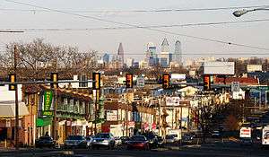 West Chester Pike with the Center City Philadelphia skyline in the background | |
| Nickname(s): UD | |
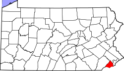
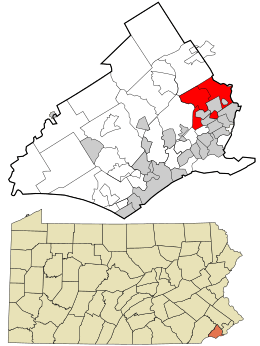 Location in Delaware County and the state of Pennsylvania. | |
.svg.png) Location of Pennsylvania in the United States | |
| Coordinates: 39°57′30″N 75°18′29″W / 39.95833°N 75.30806°WCoordinates: 39°57′30″N 75°18′29″W / 39.95833°N 75.30806°W | |
| Country | United States |
| State | Pennsylvania |
| County | Delaware |
| Settled | 1653 |
| Government | |
| • Mayor | Thomas N. Micozzie |
| Area[1] | |
| • Total | 7.83 sq mi (20.27 km2) |
| • Land | 7.83 sq mi (20.27 km2) |
| • Water | 0.00 sq mi (0.00 km2) |
| Elevation | 230 ft (70 m) |
| Population (2010) | |
| • Total | 82,795 |
| • Estimate (2016)[2] | 82,629 |
| • Density | 10,559.62/sq mi (4,076.89/km2) |
| Time zone | UTC-5 (EST) |
| • Summer (DST) | UTC-4 (EDT) |
| ZIP code | 19082 |
| Area code(s) | 610 and 484 |
| FIPS code | 42-045-79000 |
| Website |
www |

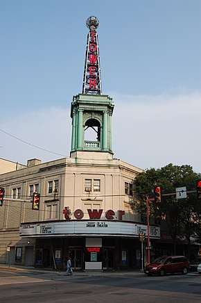
Upper Darby Township (often shortened to simply Upper Darby) is a home rule township[3] bordering Philadelphia in Delaware County, Pennsylvania, United States. Upper Darby is home to the Tower Theater, a historic music venue on 69th Street built in the 1920s. Upper Darby's population is diverse, representing over 100 ethnic cultures. The township hosts a range of housing types including densely populated rowhouse sections similar to houses in neighboring West Philadelphia, tree-lined neighborhoods of turn-of-the-century single-family houses and mid-century developments. It is Pennsylvania's sixth most populous municipality.
Upper Darby is 65% residential, 25% commercial, and 8% other. As of the 2010 census, the township had a total population of 82,795.[4] Because of a home-rule charter adopted in 1974 and effective in 1976,[3] Upper Darby utilizes a mayor-council form of management, unlike communities that are still under the Pennsylvania Township Code. ("First Class" townships in Pennsylvania have a board of commissioners divided into wards, and "Second Class" townships having a board of supervisors, which are usually elected "at-large".)
History
Early settlement
In 1650, the area that eventually became Upper Darby had been inhabited by the Lenape tribe of Native Americans for hundreds of years, but war with the Susquehannock to the west along with devastating smallpox and measles epidemics had significantly reduced their numbers. The first permanent Europeans settlers arrived in late 1653 with a group from New Sweden. Soon after, in 1655, New Sweden was taken over by the Dutch, and then came under English rule in October 1664 as part England's overall conquest of New Amsterdam. The region was controlled as a possession of the English king until it was included in a large land grant to William Penn in 1681.
Upon Penn's founding of the colony of Pennsylvania the next year, the area was designated as part of the municipality of Darby Township, in Chester County. It was subsequently part of the eastern section of that county which was split off on September 26, 1789, to form Delaware County.[5]
The Lower Swedish Cabin, thought to have been built in 1654, is located on Creek Road along the Darby Creek and is believed by many to be a remnant of the early Swedes, who introduced the log cabin to this area. Today the "Swedish Cabin" is designated with a Pennsylvania Historical Marker. The Cabin is also on the National Register of Historic Places.[6]
Division of Upper and Lower Darby
Darby Township originally occupied the area between the current border of Upper Darby to the north, Cobbs Creek and then Darby Creek to the east and south, and Ridley and Springfield townships to the west. This continued until 1736, when, for the convenience of the inhabitants, it was decided at a town meeting to separate the upper part from the lower "in all matters save the levies made for the support of the poor," with the northern part thereafter to be called Upper Darby Township. The exact boundary was not established until 1787, when a petition was presented to the court. The following is an excerpt from this petition:
Beginning at Cobb's Creek on the Northwest side of a tract of land belonging to the heirs of Joshua Ash and in the line of said land, thence along said line and the line of land late Enoch Bonsall's & Joshua Bonsall's to Darby Creek thence down the said Creek to the northwest line of John Ash's land, thence along said line and the line of Samuel Ash and Nathaniel Smith to the line of Ridley Township, and that the lower part may be called Darby and the other part Upper Darby.[7]
19th and 20th centuries
Reflecting the Quaker background of its earliest English settlers, Upper Darby was active in the antislavery movement. At least one abolition society existed prior to 1830, and sent a committee of twelve prominent citizens to the 1830 meeting of the Pennsylvania Anti-Slavery Society in Philadelphia.[8]
Many homes in the area were stops on the Underground Railroad, including Hoodland, the home of abolitionist Thomas Pennock, which was eventually bequeathed to the township's public library and which currently houses the children's library, connected to a much larger modern annex which houses the Main Branch. Another prominent abolitionist, Thomas Garrett, grew up in the township and Thornfield, his home until the age of 32, still stands at Garrett Road and Maple Avenue in the Drexel Hill section of the township. Two regiments from Upper Darby took part in the fighting in the American Civil War, and one, the 106th, was involved in the Battle of Antietam.
The abundance of creeks and streams in the area favored the development of mills, and it was in Upper Darby that the first mills in Delaware County could be found. The mill trade greatly increased the population of the township, from just over 800 in 1800 to almost 5,000 by 1890. However, beginning in 1885, the township also lost large sections of territory as the citizens of more populated neighborhoods petitioned the state to be recognized as separate municipalities. The first of these was the borough of Clifton Heights (incorporated on June 1, 1885), followed by the boroughs of Lansdowne (July 6, 1893), Aldan (September 22, 1893), Millbourne (October 12, 1909), and East Lansdowne (June 3, 1911). (Part of the territory of Aldan was also taken from Darby Township.)
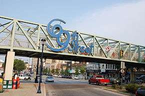
In 1907, the Philadelphia Rapid Transit Company recognized the potential for growth in the township and extended the Market-Frankford elevated train line (or "El") from just west of the Schuylkill River in Philadelphia to 69th and Market Streets in Upper Darby. The El terminus at 69th Street Station became a busy terminal serving several trolley and light rail lines into the suburbs, as well as numerous city and suburban bus routes. Commuter traffic spurred the development of the 69th St. shopping district in the 1920s by John McClatchy, and made Upper Darby the second busiest shopping area in the region, second only to Center City Philadelphia. The business district is noted for many fine examples of Art Deco style buildings. A population explosion in the township followed, and by the 1960s Upper Darby ranked as the 7th most populous municipality in Pennsylvania.[9]
In the early 1970s, students from Highland Park Elementary School began a campaign to have the Pennsylvania Firefly declared the official state insect of Pennsylvania. With advice and support from state legislators, the students began a campaign that included letter writing, the circulation of petitions, and the distribution of bumper stickers. On April 10, 1974, Governor Milton J. Shapp signed their bill making the Pennsylvania Firefly their state's official insect. A couple of years later, Highland Park Elementary School was presented with a bronze plaque in honor of the students' achievement.[10][11]
In 1991, five Upper Darby policemen were convicted in federal court and sentenced to prison for violating the civil rights of two residents, a father and son. Each was found guilty on several counts involving assault, false arrest, and prosecution.[12]
Arts and culture
The Tower Theater, located in Terminal Square at the intersection of 69th and Ludlow Streets, opened as a movie and vaudeville theater in 1927. After closing briefly, the Tower reopened as a concert venue in 1972, and has hosted acts including the first American tours of David Bowie and Genesis. In addition to musical acts, the Tower has hosted comedians such as Trevor Noah and Jim Norton.
Upper Darby Summer Stage is one of the nation's oldest youth theater programs.[13]
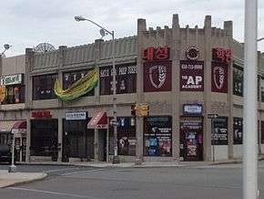
Centered in Terminal Square and the West Chester Pike business districts, Upper Darby restaurants feature a diverse range of cuisines including Vietnamese, Thai, Liberian, Italian, Korean, Mexican, and Colombian. The community is also known for its Irish pubs, and the Llanerch Diner was the setting for a pivital seen in the film Silver Linings Playbook.
The Upper Darby International Festival is an annual event held in September on 69th Street. The festival features performances, artwork, and food reflecting the diverse cultural backgrounds of the Upper Darby community.[14]
Geography
According to the United States Census Bureau, the township has a total area of 7.9 square miles (20.4 km²). The township lies on the edge of the Piedmont slightly above the City of Philadelphia (60 to 260 ft or 18 to 79 m above sea level). The area is crossed by several small creeks. The borough of East Lansdowne, Pennsylvania is an enclave completely surrounded by Upper Darby Township; additionally, an exclave of Upper Darby Township is separated from the rest of the township.
The census-designated place of Drexel Hill and the neighborhoods of Aronimink, Beverly Hills, Bywood, Drexel Park, Highland Park, Llanerch Hills, Kellyville, Kirklyn, Oakview, Primos, Secane, Stonehurst, Terminal Square, and Westbrook Park are part of Upper Darby Township.
Cobbs Creek runs along the border of Upper Darby and connects with Darby Creek.
Cobbs Creek Park abuts the Highland Park Neighborhood of Upper Darby along the border with the Overbrook neighborhood of Philadelphia.
Transportation
SEPTA's 69th Street Transportation Center is located in Terminal Square on 69th Street. It serves as the western terminal stop of the Market-Frankford Line, the eastern terminal stop of the Norristown High Speed Line (formerly Route 100) and SEPTA trolley routes 101 and 102, as well as SEPTA Bus Routes 21, 30, 65, 68, 103, 104, 105, 106, 107, 108, 109, 110, 111, 112, 113, 120, 123, and 126. The Norristown High Speed Line has stops in Upper Darby at 69th Street and Parkview Station.
Pennsylvania Route 3, which links Philadelphia and West Chester passes through Upper Darby as Market Street and the West Chester Pike.
Emergency services
Upper Darby Township is served by the 133-member Upper Darby Police Department, the Crozer-Keystone North Division Paramedics (based out of Delaware County Memorial Hospital), and the Upper Darby Township Fire Department, a combination paid/volunteer department which consists of a headquarters building and 5 stations:
- Company 20 - Garrettford-Drexel Hill (which is the only full-time volunteer station), housing 3 pumpers (engines), one ladder truck, and one rescue truck.
- Company 26 - Highland Park, housing 2 pumpers, and one rescue truck.
- Company 36 - Cardington-Stonehurst, housing one pumper, one squirt, and one mask service unit
- Company 37 - Upper Darby, housing one ladder truck and one utility truck.
- Company 74 - Primos-Secane-Westbrook Park, one ladder truck and one tower ladder truck.
Libraries

Upper Darby Township has three public library branches as part of the Delaware County Library System:
- Sellers Memorial Free Library
- Free Library Municipal Branch
- Free Library Primos Branch
Religious organizations
Upper Darby houses of worship include Protestant Christian, Catholic, Greek Orthodox churches and an Islamic center.
Cemeteries
- Friends Southwestern Burial Ground, a Quaker cemetery founded in 1860.
- Arlington Cemetery, a non-denominational burial ground founded in 1895.
- Har Jehuda Cemetery, a Jewish burial ground founded in 1896.
- Montrose Cemetery, privately owned founded 1896
Neighborhoods
- Addingham
- Aronimink
- Bywood
- Drexel Hill
- Highland Park
- Kirklyn
- Primos
- Secane
- Terminal Square
- Stonehurst
Adjacent municipalities
- Philadelphia City, Philadelphia County - east (West Philadelphia), north (Overbrook)
- Millbourne Borough, Delaware County – northeast
- East Lansdowne Borough, Delaware County – southeast
- Yeadon Borough, Delaware County – southeast
- Lansdowne Borough, Delaware County – south
- Darby Borough, Delaware County – south
- Clifton Heights, Delaware County – south
- Aldan Borough, Delaware County – south
- Darby Township, Delaware County – south
- Ridley Township, Delaware County – southwest
- Springfield Township, Delaware County – west
- Haverford Township, Delaware County – west
Demographics
| Historical population | |||
|---|---|---|---|
| Census | Pop. | %± | |
| 1930 | 47,145 | — | |
| 1940 | 56,883 | 20.7% | |
| 1950 | 84,951 | 49.3% | |
| 1960 | 93,158 | 9.7% | |
| 1970 | 95,910 | 3.0% | |
| 1980 | 84,054 | −12.4% | |
| 1990 | 81,777 | −2.7% | |
| 2000 | 81,821 | 0.1% | |
| 2010 | 82,795 | 1.2% | |
| Est. 2016 | 82,629 | [2] | −0.2% |
| U.S. Decennial Census[15] | |||
Upper Darby is one of Pennsylvania's most diverse communities.[16] As of Census 2010, the racial makeup of the township was 56.6% White, 27.5% African American, 0.2% Native American, 11.1% Asian, 1.9% from other races, and 2.7% from two or more races. Hispanic or Latino of any race were 4.5% of the population .
As of the census[17] of 2000, there were 85,038 people, 32,551 households, and 20,474 families residing in the township. The population density was 14,658.7 people per square mile. There were 34,322 housing units at an average density of 4,361.6 per square mile (1,683.8/km²). The racial makeup of Upper Darby was 59.1% White; 20.5% African American; 15.3% Asian; 0.12% Native American; 0.03% Pacific Islander; 0.52% from other races and 2.3% from two or more races. Hispanics or Latinos of any race were 2.4% of the population
There were 32,551 households, out of which 31.0% had children under the age of 18 living with them, 45.0% were married couples living together, 13.4% had a female householder with no husband present, and 37.1% were non-families. 31.6% of all households were made up of individuals, and 11.5% had someone living alone who was 65 years of age or older. The average household size was 2.50 and the average family size was 3.23.
In the township the population was spread out, with 25.2% under the age of 18, 8.4% from 18 to 24, 32.8% from 25 to 44, 19.9% from 45 to 64 and 13.7% who were 65 years of age or older. The median age was 35 years. For every 100 females, there were 91.6 males. For every 100 females age 18 and over, there were 88.2 males.
The median income for a household in the township was $41,489, and median income for a family was $52,500. Males had a median income of $38,090 versus $30,416 for females. The per capita income for the township was $20,770. About 7.3% of families and 9.1% of the population were below the poverty line, including 11.1% of those under age 18 and 6.9% of those age 65 or over.[18]
Historic sites
- Collen Brook Farm was listed on the National Register of Historic Places in 1988.[19] It was the home of political leader George Smith.
- Lower Swedish Cabin was listed on the National Register of Historic Places in 1980. It is believed to be the oldest building in Pennsylvania, and one of the oldest log cabins in the United States.
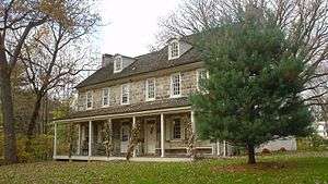
- Sellers Hall is one of the oldest buildings in Pennsylvania, and was the ancestral home to one of Upper Darby's earliest settling families, the Sellers. The oldest part of the building was built in 1684 by Samuel Sellers. [20]
Education
Upper Darby Township's public education is provided by the Upper Darby School District. In all, the 12 public schools plus the Kindergarten Center serve nearly 12,000 students. The district has one high school, Upper Darby High School, two middle schools, Beverly Hills Middle School and Drexel Hill Middle School, and 10 public elementary schools. Established in 1895, Upper Darby High School is the largest high school in Pennsylvania with almost 4,000 students.
In addition to the public school district, Upper Darby is home to several parochial and private schools. Monsignor Bonner High School (for boys) and Archbishop Prendergast High School (for girls), both Roman Catholic, are the largest private schools in the Township. Both schools offer grades 9–12 with a combined enrollment close to 5,500 students. In addition to the two high schools, there are nine parochial primary and middle schools located in the Township, with a combined enrollment of 2,867. Almost all of the private academic schools in the Township are administered by the Archdiocese of Philadelphia except for the Holy Child Academy, which is a Catholic academy run by the Society of the Holy Child Jesus.
Also available to residents of Upper Darby and surrounding areas is the Upper Darby Adult Evening Program (UDAEP). UDAEP offers professional development and general education classes to township residents. UDAEP is an independent non-profit entity separate from the Upper Darby School District.[21]
Delaware County Community College's Upper Darby Center holds day and evening classes serving 600 students.[22]
Politics
In the 2016 Presidential Election, Democrat Hillary Clinton received 25,475 votes, Republican Donald Trump received 11,967 votes, with independent parties receiving just over 1,000 votes in Upper Darby.[23]
In the 2016 U.S. Senate race, Democrat Katie McGinty received 23,294 votes over Republican Pat Toomey, who received 13,539 votes in Upper Darby.[24]
In local politics, Republicans represent a majority of the Township Council seats, Democrats hold a majority of the School Board seats, and the mayorship is held by Republican Thomas N. Micozzie.[25]
In popular culture
The 2012 David O. Russell film Silver Linings Playbook is set in Upper Darby.[26]
Woody Allen's 2012 essay "Not a Creature Was Stirring," in the "Shouts and Murmurs" section of the New Yorker mentions Upper Darby.[27]
The 1978 William Wharton novel Birdy was set in Upper Darby; the author disguised its identity in the text by calling it "Upper Merion", even though there already existed a municipality of that same name.
Notable people
- Lloyd Alexander (born 1924), author[28]
- Keith Andes (1920-2005), actor
- Patrice Banks, engineer and mechanic, founder of Girls Auto Clinic [29]
- Anthony Becht (born 1977), NFL football player
- John Cappelletti (born 1952), NFL football player
- Dick Clark (1929-2012), entertainer
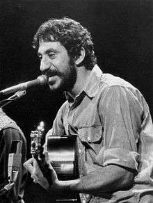
- Jim Croce (1943-1973), singer songwriter
- Mark Cronin, television producer
- Margo L. Davidson (born 1964), broadcaster, member of the Pennsylvania House of Representatives
- George Delahunty (born 1952), physiologist, endocrinologist, and professor at Goucher College
- Heather Donahue (born 1974), writer, actress
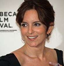
- Tina Fey (born 1970), comedian, writer, actress[30]
- D'or Fischer (born 1981), American-Israeli basketball player.
- Monica Horan (born 1963), actress
- Jamie Kennedy (born 1970), comedian
- Simoni Lawrence (born 1989), football player
- David MacAdam (1910-1998), Physicist and color scientist
- Ed McMahon (1923-2009), co-host, Tonight Show with Johnny Carson
- Pat Meehan (born 1955), U.S. Representative Pennsylvania 7th District
- Shannon Meehan, author and veteran's activist[31]
- Terrence J. Nolen (born 1963), theater director, co-founder of the Arden Theater Company[32]
- Cheri Oteri (born 1962), comedian, actress
- Dorothy Germain Porter, golfer
- Todd Rucci (born 1970), football player
- Todd Rundgren (born 1948), musician
- Alvin Sargent (born 1927), screenwriter[33]
- Herb Sargent (1923-2005), television and film screenwriter
- Mike Scioscia (born 1958) baseball player, manager Los Angeles Angels
- Jerome Socolovsky, journalist for NPR, and Voice of America.
- Ed Stefanski, former NBA player, executive
- Marty Stern (born 1936), women's track coach
- George Wackenhut (1919-2004), founder of the Wackenhut private security firm.[34]
- Immanuel Spencer Whitfield Wilkins (born 1997), musician, composer, arranger, band leader
- William Wharton (1925-2008), author
- F. Joseph "Joe" Loeper (born 1944), American politician (resigned) who represented the 26th senatorial district from 1979 through 2000 in the Pennsylvania State Senate, including over 10 years as Republican Majority Leader[35][36]
See also
References
- ↑ "2016 U.S. Gazetteer Files". United States Census Bureau. Retrieved Aug 13, 2017.
- 1 2 "Population and Housing Unit Estimates". Retrieved June 9, 2017.
- 1 2 "Archived copy" (PDF). Archived from the original (PDF) on May 27, 2011. Retrieved June 5, 2009.
- ↑ Bureau, U.S. Census. "American FactFinder - Results". Retrieved February 25, 2017.
- ↑ "Historically Speaking" (PDF). Udhistory.org. Upper Darby Historical Society. 2007. Archived from the original (PDF) on January 5, 2009. Retrieved February 26, 2017.
- ↑ "Archived copy". Archived from the original on May 5, 2009. Retrieved May 7, 2009.
- ↑ Ashmead, Henry Graham (1884). "History of Delaware County, Pennsylvania (1884)". Internet Archive. Philadelphia, L. H. Everts & co. Retrieved 24 February 2014.
- ↑ A History of Delaware County, Pennsylvania. Ed. John W. Jordan. NY: Lewis Historical Publishing, 1914. quoted in A History of Upper Darby; History.rays-place.com
- ↑ "Archived copy". Archived from the original on May 5, 2009. Retrieved May 7, 2009.
- ↑ "Text Only Version". Burger.com. Retrieved 2017-02-26.
- ↑ "Pennsylvania State Insect | Firefly". Statesymbolsusa.org. 1974-04-10. Retrieved 2017-02-26.
- ↑ "5 U. Darby Officers Convicted Jury: Violated Civil Rights Of 2". Philly.com. The Philadelphia Inquirer. May 29, 1991. Retrieved September 25, 2016.
- ↑ "Upper Darby Summer Stage - Upper Darby Performing Arts Center". Retrieved August 16, 2018.
- ↑ http://www.philly.com/philly/calendar/492531121.html
- ↑ "Census of Population and Housing". Census.gov. Retrieved June 4, 2016.
- ↑ "2018 Most Diverse ZIP Codes in Pennsylvania". Niche. Retrieved August 16, 2018.
- ↑ "American FactFinder". United States Census Bureau. Retrieved 2008-01-31.
- ↑ Delaware County Today/Almanac: 81st Edition
- ↑ National Park Service (2010-07-09). "National Register Information System". National Register of Historic Places. National Park Service.
- ↑ "Friends of Sellers Hall". sellershall.org. Retrieved August 16, 2018.
- ↑ "Archived copy". Archived from the original on November 28, 2006. Retrieved January 31, 2007.
- ↑ "Delaware County Community College - Find yourself here. - 1". www.dccc.edu. Retrieved August 16, 2018.
- ↑ http://election.co.delaware.pa.us/eb/November_2016/Official/16.html
- ↑ http://election.co.delaware.pa.us/eb/November_2016/Official/16.html
- ↑ https://www.upperdarby.org/Gov/Council/About_Council.html?id=161
- ↑ "The Llanerch to JLaw's House, Silver Linings Playbook Mapped". Retrieved August 16, 2018.
- ↑ "Not a Creature Was Stirring". Retrieved August 16, 2018.
- ↑ "Celebrating the works of Lloyd Alexander". Retrieved August 16, 2018.
- ↑ "Five for Friday: Girls Auto Clinic's Patrice Banks". February 19, 2016. Retrieved August 16, 2018.
- ↑ "Tina Fey Returns Home, Talks Pizza & Mean Girls". Retrieved August 16, 2018.
- ↑ "Upper Darby soldier lauded for service". Retrieved August 16, 2018.
- ↑ "The Ripple Effect: The impact of Upper Darby Summer Stage radiates far beyond the walls of the UD Performing Arts Center. - Upper Darby Performing Arts Center". June 29, 2015. Retrieved August 16, 2018.
- ↑ "Portraits of Delaware County: Alvin Sargent - Award Winning Screenwriter". Retrieved August 16, 2018.
- ↑ "From FBI reject to private warlord: the rise of George Wackenhut". Retrieved August 16, 2018.
- ↑ "Senate Floor Leaders since 1950". The Pennsylvania Manual. 118. Harrisburg, PA: Pennsylvania Department of General Services. 2007. pp. 3–265.
- ↑ Center, Legislativate Data Processing. "F Joseph Loeper". The official website for the Pennsylvania General Assembly. Retrieved August 16, 2018.
External links
| Wikimedia Commons has media related to Upper Darby, Pennsylvania. |
- Upper Darby Township
- Upper Darby Township & Sellers Memorial Free Public Libraries
- Upper Darby Performing Arts Center
- History and Development of Upper Darby
- Friends of the Swedish Cabin
| Preceded by Yeadon |
Bordering communities of Philadelphia With: Millbourne |
Succeeded by Haverford Township |
Places adjacent to Upper Darby Township, Delaware County, Pennsylvania | |
|---|---|