Swarthmore, Pennsylvania
| Swarthmore, Pennsylvania | |
|---|---|
| Borough | |
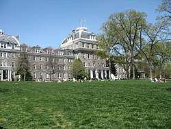 Parrish Hall at Swarthmore College | |
 Swarthmore Location of Swarthmore in Pennsylvania  Swarthmore Swarthmore (the US) | |
| Coordinates: 39°54′06″N 75°20′49″W / 39.90167°N 75.34694°WCoordinates: 39°54′06″N 75°20′49″W / 39.90167°N 75.34694°W | |
| Country | United States |
| State | Pennsylvania |
| County | Delaware |
| Government | |
| • Mayor | Tim Kearney (D)[1] |
| Area[2] | |
| • Total | 1.40 sq mi (3.63 km2) |
| • Land | 1.40 sq mi (3.63 km2) |
| • Water | 0.00 sq mi (0.00 km2) |
| Elevation | 125 ft (38 m) |
| Population (2010) | |
| • Total | 6,194 |
| • Estimate (2016)[3] | 6,239 |
| • Density | 4,456.43/sq mi (1,720.77/km2) |
| Time zone | UTC-5 (EST) |
| • Summer (DST) | UTC-4 (EDT) |
| ZIP code | 19081 |
| Area code(s) | 610 and 484 |
| FIPS code | 42-045-75648 |
| FIPS code | 42-75648 |
| GNIS feature ID | 1189142 |
| Website |
www |
Swarthmore (/ˈswɔːrθmɔːr/, locally [swɑθ-]) is a borough in Delaware County, Pennsylvania, United States. Swarthmore was originally named "Westdale" in honor of noted painter Benjamin West, who was one of the early residents of the town. The name was changed to "Swarthmore" after the establishment of Swarthmore College. The borough population was 6,194 as of the 2010 census.[4]
History
The borough was originally part of Springfield Township, and grew up around Swarthmore College, which was founded in 1864. The advent of passenger rail service from Philadelphia in the 1880s greatly enhanced the desirability of the borough as a commuter suburb, and the borough was incorporated in 1893.
The Ogden House and Benjamin West Birthplace are listed on the National Register of Historic Places.[5]
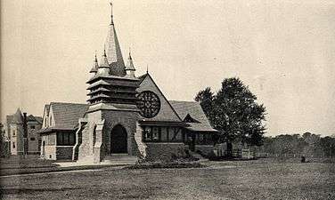 Presbyterian Church, designed by Will Price, about 1897
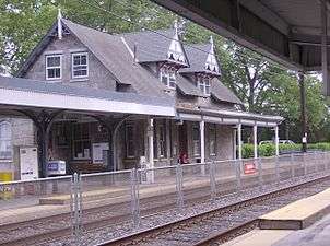 Swarthmore SEPTA Station
Geography
Swarthmore is located in east-central Delaware County at 39°54′6″N 75°20′49″W / 39.90167°N 75.34694°W (39.901788, -75.347083).[6] It is bordered to the north, east, and southwest by Springfield Township, to the southeast by Ridley Township, and to the west by Nether Providence Township. Crum Creek, a south-flowing tributary of the Delaware River, forms the western boundary of the borough.
According to the United States Census Bureau, Swarthmore borough has a total area of 1.40 square miles (3.63 km2), all of it land.[4]
Government
Swarthmore is represented in the Pennsylvania General Assembly as the PA 161st Legislative District and the PA 26th Senate District. The former position is held until 2017 by Leanne Krueger-Braneky[7][8] and the latter until 2019 by Tom McGarrigle.[9]
Demographics
| Historical population | |||
|---|---|---|---|
| Census | Pop. | %± | |
| 1900 | 903 | — | |
| 1910 | 1,899 | 110.3% | |
| 1920 | 2,350 | 23.7% | |
| 1930 | 3,405 | 44.9% | |
| 1940 | 4,061 | 19.3% | |
| 1950 | 4,825 | 18.8% | |
| 1960 | 5,753 | 19.2% | |
| 1970 | 6,156 | 7.0% | |
| 1980 | 5,950 | −3.3% | |
| 1990 | 6,157 | 3.5% | |
| 2000 | 6,170 | 0.2% | |
| 2010 | 6,194 | 0.4% | |
| Est. 2016 | 6,239 | [3] | 0.7% |
| Sources:[10][11][12] | |||
As of the census[11] of 2010, there were 6,194 people, 1,963 households, and 1,327 families residing in the borough. The population density was 4,460.4 inhabitants per square mile (1,722.2/km2). There were 2,081 housing units at an average density of 1,492.1 per square mile (576.1/km2). The racial makeup of the borough was 82.5% White, 7.7% Asian, 5.0% African American, 0.3% Native American, 0.1% Pacific Islander, .7% from other races, and 3.8% from two or more races. Hispanic or Latino of any race were 4.9% of the population.
There were 1,963 households, out of which 34.1% had children under the age of 18 living with them, 57.3% were married couples living together, 7.8% had a female householder with no husband present, 2.4% had a male householder with no wife present, and 32.4% were non-families. 27.6% of all households were made up of individuals, and 12.5% had someone living alone who was 65 years of age or older. The average household size was 2.48 and the average family size was 3.06.
In the borough the population was spread out, with 20.7% under the age of 18, 15.8% from 20 to 24, 15.3% from 25 to 44, 25.4% from 45 to 64, and 12.4% who were 65 years of age or older. The median age was 30.8 years. For every 100 females, there were 89.7 males. For every 100 females age 18 and over, there were 86.9 males.[13]
As of 2015, the median income for a household in the borough was $101,686, and the median income for a family was $144,570.[13] Males had a median income of $71,750 versus $51,117 for females. The per capita income for the borough was $40,482. About 0.0% of families and 2.3% of the population were below the poverty line.[13]
Education
Swarthmore lies within the Wallingford-Swarthmore School District. According to Pennsylvania state policy, Swarthmore is considered too small a town to have its own secondary schools. Hence, in 1984 Swarthmore High School merged with adjacent Nether Providence High School to form Strath Haven High School.
Public schools
| Grades | School |
|---|---|
| Kindergarten - 5 | Nether Providence Elementary School Swarthmore-Rutledge Elementary School Wallingford Elementary School |
| 6 - 8 | Strath Haven Middle School |
| 9 - 12 | Strath Haven High School |
The borough is home to Swarthmore College, on whose campus is the Benjamin West House (the home of Benjamin West), a painter who lived in what is currently known as Swarthmore, but was Springfield at the time.
Private and religious schools
- George Crothers Memorial School at CADES
Cultural institutions
Scott Arboretum is located on the campus of Swarthmore College.
The Swarthmore Public Library is at 121 Park Avenue in the center of the borough.
Transportation
Swarthmore Station, a SEPTA Regional Rail train station on the Media/Elwyn Line, sits between the college and the town's center.
SEPTA Route 109 bus connecting Chester with Upper Darby stops along Chester Road.
Notable people
References
- ↑ "2013 Un-Official Municipal Election Results for Swarthmore Borough". Delaware County Elections Bureau. Retrieved 5 February 2016.
- ↑ "2016 U.S. Gazetteer Files". United States Census Bureau. Retrieved Aug 13, 2017.
- 1 2 "Population and Housing Unit Estimates". Retrieved June 9, 2017.
- 1 2 "Geographic Identifiers: 2010 Demographic Profile Data (G001): Swarthmore borough, Pennsylvania". U.S. Census Bureau, American Factfinder. Retrieved December 28, 2015.
- ↑ National Park Service (2010-07-09). "National Register Information System". National Register of Historic Places. National Park Service.
- ↑ "US Gazetteer files: 2010, 2000, and 1990". United States Census Bureau. 2011-02-12. Retrieved 2011-04-23.
- ↑ "Democrat Krueger-Braneky emerges victorious in 161st District". delcotimes.com. Retrieved August 7, 2015.
- ↑ "Democrat wins special election for state House seat in Delco". Philly.com. August 5, 2015. Retrieved August 7, 2015.
- ↑ "McGarrigle edges out Kane in 26th District". Delaware County Times. 5 November 2014. Retrieved 22 December 2014.
- ↑ "Census of Population and Housing". U.S. Census Bureau. Retrieved 11 December 2013.
- 1 2 "American FactFinder". United States Census Bureau. Retrieved 2008-01-31.
- ↑ "Incorporated Places and Minor Civil Divisions Datasets: Subcounty Resident Population Estimates: April 1, 2010 to July 1, 2012". Population Estimates. U.S. Census Bureau. Archived from the original on 17 June 2013. Retrieved 11 December 2013.
- 1 2 3 Bureau, U.S. Census. "American FactFinder - Results". factfinder.census.gov. Retrieved 2017-07-27.
External links
| Wikimedia Commons has media related to Swarthmore, Pennsylvania. |
- Borough of Swarthmore official website
- Swarthmore Public Library
- A Healthy Spot, originally titled Swarthmore, a 1944 poem by resident W.H. Auden.
Municipalities and communities of Delaware County, Pennsylvania, United States | ||
|---|---|---|
| City | 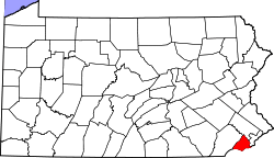 | |
| Boroughs | ||
| Townships | ||
| CDPs | ||
| Unincorporated communities |
| |
| Ghost town | ||
| Footnotes | ‡This populated place also has portions in an adjacent county or counties | |