Lansdowne, Pennsylvania
| Lansdowne, Pennsylvania | |
|---|---|
| Borough | |
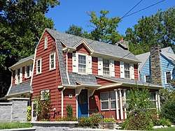 House on Stewart, 2013. | |
| Motto(s): Discover Lansdowne | |
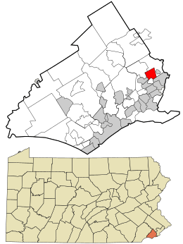 Location in Delaware County and the U.S. state of Pennsylvania. | |
 Lansdowne Location of Lansdowne in Pennsylvania  Lansdowne Lansdowne (the US) | |
| Coordinates: 39°56′29″N 75°16′31″W / 39.94139°N 75.27528°WCoordinates: 39°56′29″N 75°16′31″W / 39.94139°N 75.27528°W | |
| Country | United States |
| State | Pennsylvania |
| County | Delaware |
| Area[1] | |
| • Total | 1.18 sq mi (3.06 km2) |
| • Land | 1.18 sq mi (3.06 km2) |
| • Water | 0.00 sq mi (0.00 km2) |
| Elevation | 108 ft (33 m) |
| Population (2010) | |
| • Total | 10,620 |
| • Estimate (2016)[2] | 10,606 |
| • Density | 8,980.52/sq mi (3,466.58/km2) |
| Time zone | UTC-5 (EST) |
| • Summer (DST) | UTC-4 (EDT) |
| ZIP code | 19050 |
| Area code(s) | 610 and 484 |
| FIPS code | 42-41440 |
| GNIS feature ID | 1178879 |
| Website |
www |
Lansdowne is a borough in Delaware County, Pennsylvania, United States located 6 miles (10 km) southwest of the City Center of Philadelphia. It was named for the Marquess of Lansdowne. As of the 2010 census the borough had a population of 10,620.[3]
Lansdowne grew quickly in the early part of the twentieth century when a railroad stop was established near the intersection of Lansdowne Avenue and Baltimore Pike. The borough is primarily residential with a commercial center near the original railroad stop. The borough also contained some light industrial buildings which have been in decline in recent decades.
The borough is sometimes erroneously spelled "Landsdowne" or confused with Lansdale, in nearby Montgomery County.
Geography
Lansdowne is located in eastern Delaware County at 39°56′29″N 75°16′31″W / 39.94139°N 75.27528°W (39.941345, -75.275343).[4] It is bordered to the southeast by Yeadon, to the southwest by Aldan and Clifton Heights, and to the north, east, west, and south by Upper Darby Township. Drexel Hill, a part of Upper Darby Township, borders Lansdowne to the northwest, and the borough of East Lansdowne is just 0.1 miles (0.16 km) east of the Lansdowne border.
According to the United States Census Bureau, the borough has a total area of 1.2 square miles (3.1 km2), all land.[3] Darby Creek, a tributary of the Delaware River, forms the southwest and southern border of the borough.
Demographics
| Historical population | |||
|---|---|---|---|
| Census | Pop. | %± | |
| 1890 | 875 | — | |
| 1900 | 2,630 | 200.6% | |
| 1910 | 4,066 | 54.6% | |
| 1920 | 4,797 | 18.0% | |
| 1930 | 9,023 | 88.1% | |
| 1940 | 10,837 | 20.1% | |
| 1950 | 12,169 | 12.3% | |
| 1960 | 12,601 | 3.6% | |
| 1970 | 14,090 | 11.8% | |
| 1980 | 11,891 | −15.6% | |
| 1990 | 11,712 | −1.5% | |
| 2000 | 11,044 | −5.7% | |
| 2010 | 10,620 | −3.8% | |
| Est. 2016 | 10,606 | [2] | −0.1% |
| [5][6][7][8] | |||
As of the census[7] of 2010, there were 10,620 people, 4,589 households, and 2,667 families residing in the borough. The population density was 8,990.2 people per square mile (3,471.2/km²). There were 4,975 housing units at an average density of 4,211.5 per square mile (1,626.1/km²). The racial makeup of the borough was 47.1% White, 44.6% African American, 0.2% Native American, 3.6% Asian, 0.01% Pacific Islander, 0.7% some other race, and 3.8% from two or more races. Hispanic or Latino of any race were 3.3% of the population.[9]
There were 4,589 households, out of which 28.1% had children under the age of 18 living with them, 38.4% were husband–wife families, 15.2% had a woman householder with no husband present, and 41.9% were non-families. 34.8% of all households were made up of people living alone, and 10.9% were someone living alone who was 65 years of age or older. The average household size was 2.31, and the average family size was 3.04.[9]
In the borough 21.4% of the population were under the age of 18, 8.2% were from 18 to 24, 28.2% were from 25 to 44, 30.0% were from 45 to 64, and 12.4% were 65 years of age or older. The median age was 39.7 years. For every 100 women there were 86.1 males. For every 100 women age 18 and over, there were 82.3 males.[9]
For the period 2010-14, the estimated median annual income for a household in the borough was $56,020, and the median income for a family was $74,656. Male full-time workers had a median income of $51,534 versus $50,276 for women. The per capita income for the borough was $31,158. About 10.1% of families and 10.4% of the population were below the poverty line, including 11.4% of those under age 18 and 14.2% of those age 65 or over.[10]
Education
Primary and secondary schools
Public schools
William Penn School District serves Lansdowne.
- Ardmore Avenue Elementary School (K-6)
- Penn Wood Middle School (7-8) (Darby)
- Penn Wood High School 9th Grade Academy, Cypress Street Campus, (9) (Yeadon)
- Penn Wood High School, Green Avenue Campus, (10-12)
Private schools
Lansdowne Friends School is a Quaker elementary school. Saint Philomena School operated for over 100 years before closing in 2011.
Features

Lansdowne was once a vacation resort for residents of Philadelphia. People traveled by rail and horse to relax in the borough's Victorian homes. Many of the homes have since been turned into multiple-dwelling apartments which, due to zoning law changes, is no longer an option. Lansdowne is trying to preserve the integrity of its lovely, big homes.
It is home to numerous arts organizations, including the Lansdowne Symphony Orchestra, Celebration Theater, the Lansdowne Folk Club, and the Lansdowne Arts Festival. The Farmers Market runs, rain or shine, on Saturdays from 9 am to 1 pm, between Memorial Day and Halloween.
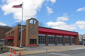
The fire department was incorporated December 4, 1894, and provides a career ambulance service alongside a volunteer fire service. The borough's fire service is supplemented by the Yeadon, Clifton Heights, East Lansdowne, and Garrettford-Drexel Hill Fire Companies.
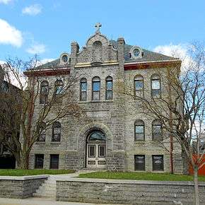
The borough has several historic buildings, including a movie theater and clubhouse, and two areas that are on the National Register of Historic Places. They are the Lansdowne Theater, Twentieth Century Club of Lansdowne, Henry Albertson Subdivision Historic District, and Lansdowne Park Historic District.[11] There has recently been a movement to re-open the theater. The marquee was ceremoniously re-lit on October 5, 2012[12] after much reconstruction, indicating that the movement is healthy.
A community of Scottish weavers lived and worked on Scottdale Road by the Darby Creek in the 19th century. Some of their houses are still in existence. A Quaker community and a Friends' Meeting House are located on Lansdowne Avenue.
Lansdowne is also home to a 350-year-old sycamore tree, one of the largest in the state of Pennsylvania.[13]
Notable people
- Leroy Burrell, former world champion, world record holder, Olympic silver medalist in the 100 meters, and current track coach at the University of Houston; raised in Lansdowne
- Pat Croce, former president of the Philadelphia 76ers and founder of Novacare; raised in Lansdowne
- Jessica Dragonette, singer and movie actress, went to Lansdowne High
- Steve Gunn, musician
- Bruce Harlan, Olympic gold medalist in diving; raised in Lansdowne
- Joan Jett, rock and roll musician; lived in Lansdowne as a child
- Jeff LaBar, best known from the band Cinderella; native
- Andrea Lee, New Yorker short story writer; lived in Lansdowne as a child and attended Lansdowne Friends School
- Joe Lunardi, ESPN college basketball analyst and creator of "Bracketology"; longtime resident of Lansdowne
- Larry Mendte, former anchorman for CBS3 in Philadelphia; born and raised in Lansdowne
- Michael Marcavage, founder of Repent America, Christian News Network, and one of the Philadelphia 4; lives in Lansdowne
- Winant Sidle, U.S. Army major general; raised in Lansdowne
- Kurt Vile, indie rock musician
- Silver Linings Playbook, certain scenes of the hit blockbuster were filmed in Lansdowne
References
- ↑ "2016 U.S. Gazetteer Files". United States Census Bureau. Retrieved Aug 13, 2017.
- 1 2 "Population and Housing Unit Estimates". Retrieved June 9, 2017.
- 1 2 "Geographic Identifiers: 2010 Demographic Profile Data (G001): Lansdowne borough, Pennsylvania". U.S. Census Bureau, American Factfinder. Retrieved December 28, 2015.
- ↑ "US Gazetteer files: 2010, 2000, and 1990". United States Census Bureau. 2011-02-12. Retrieved 2011-04-23.
- ↑ "Number of Inhabitants: Pennsylvania" (PDF). 18th Census of the United States. U.S. Census Bureau. Retrieved 22 November 2013.
- ↑ "Pennsylvania: Population and Housing Unit Counts" (PDF). U.S. Census Bureau. Retrieved 22 November 2013.
- 1 2 "American FactFinder". United States Census Bureau. Retrieved 2008-01-31.
- ↑ "Incorporated Places and Minor Civil Divisions Datasets: Subcounty Population Estimates: April 1, 2010 to July 1, 2012". U.S. Census Bureau. Archived from the original on 17 June 2013. Retrieved 25 November 2013.
- 1 2 3 "Profile of General Population and Housing Characteristics: 2010 Census Summary File 1 (DP-1): Lansdowne borough, Pennsylvania". U.S. Census Bureau, American Factfinder. Retrieved December 27, 2015.
- ↑ "Selected Economic Characteristics: 2010-2014 American Community Survey 5-Year Estimates (DP03): Lansdowne borough, Pennsylvania". U.S. Census Bureau, American Factfinder. Retrieved December 28, 2015.
- ↑ National Park Service (2010-07-09). "National Register Information System". National Register of Historic Places. National Park Service.
- ↑ Tustin, Kevin. "Lansdowne Theater lit again after 25 years". Retrieved December 5, 2012.
- ↑ "Sycamore Park Pennsylvania | Official Travel Guide". www.visitpa.com. Retrieved 2015-12-29.
External links
| Wikimedia Commons has media related to Lansdowne, Pennsylvania. |
- Borough of Lansdowne official website
- Lansdowne Symphony Orchestra
- Historic Lansdowne Theater
- Gladstone Manor
- Lansdowne Economic Development Corporation
- Lansdowne Farmers Market
- Lansdowne Boys and Girls Club
Municipalities and communities of Delaware County, Pennsylvania, United States | ||
|---|---|---|
| City | 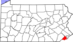 | |
| Boroughs | ||
| Townships | ||
| CDPs | ||
| Unincorporated communities |
| |
| Ghost town | ||
| Footnotes | ‡This populated place also has portions in an adjacent county or counties | |