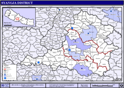
Syangja District
| Syangja District स्याङ्जा | |
|---|---|
| District | |
 The District Headquarters Putalibazar | |
 | |
| Country | Nepal |
| Province | Gandaki Pradesh |
| Admin HQ. | Putalibazar |
| Government | |
| • Type | Coordination committee |
| • Body | DCC, Syangja |
| Area | |
| • Total | 1,164 km2 (449 sq mi) |
| Population (2011) | |
| • Total | 289,148[1] |
| Time zone | UTC+5:45 (NPT) |
| Main Language(s) | Nepali |
| Website | ddcsyangja.gov.np |
Syangja District (Nepali: स्याङ्जा जिल्ला![]()
The district now has five municipalities Waling, Putalibazar, Chapakot, Bhirkot and Galyang and six village councils Bajhakot, Arjun Chaupari, Biruwa, Fedikhola, Harinas and Kaligandaki[2]
Syangja in 1994 under the auspices of the South Asia Poverty Alleviation Program (SAPAP) of the UNDP, received million of dollars of international investment and has become a model for national development. Syangja's model has proved so successful that the Government of Nepal joined forces with the SAPAP to extend the project to other districts and make it a model for national development. It has been initiated or implemented in at least 200 Village Development Councils (VDC/s) of 45 districts of Nepal.
People of many ethnicities live in this district. The major groups are Brahmin, Chetri, Gurung and Magar.
People and places
Many different ethnicity of people live in this district. The major groups consisting of Brahmin, kshetri, Gurung, Magar and others. The people are famous for their unique identity. Brahmin and Chhetri (Kshetriya) are renowned by their representation in the governmental jobs and Indian army respectively. Gurungs and Magars are famous because of their involvement in British Army Gurkhas and Military of India. There is a popular saying that "when you go to Syangja and hit randomly a house with a stone that house surely belongs to Section-Officer."
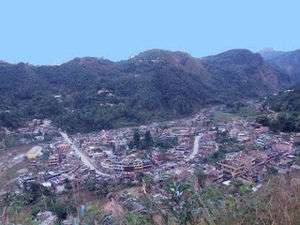
The headquarters of Syanga district lies at Syangja bazaar. Some places of historical interest in this district are Satahun Chandi, Manakamana, Bhirkot Durbar, Alamdevi, Gahraukalika, Nuwakot Durbar, Chhangchhangdi and Ridi Ruru Kshetra on the banks of Kaligandaki river. Chhangchhangdi (Chaya-kshetra) is mentioned in the Swasthani Vrata-Katha, considered to be a part of the Skanda Purana, as the place where the last organ of dead Satidevi fell when she was being carried by Lord Shiva. Among the three municipalities, Putalibazar municipality lies in the eastern side whereas Waling municipality in the western Syangja, the newly formed Chapakot municipality is on the east-south. Waling is a longitudinal valley along the banks of the beautiful Aandhikhola river. According to one popular folk legend, Aandhikhola river is believed to be originated from the tears of Shravan of the Ramayana. The largest valley in Syangja is Ramkosh.
Political division
Syangja district has 11 local units among them five are municipalities (Nagarpalika) and six rural municipalities (guanpalika) recently with the formulation of new constitution and provincial division of the country.
- Galyang Municipality
- Chapakot Municipality
- Putalibazar Municipality
- Bheerkot Municipality
- Waling Municipality
- Arjun Chaupari Rural Municipality
- Aandhikhola Rural Municipality
- Kaligandaki Rural Municipality
- Phedikhola Rural Municipality
- Bajhakot Rural Municipality
- Harinas Rural Municipality
- Biruwa Rural Municipality
Former Village Development Committees and municipalities
- Alamdevi
- Arjun Chaupari
- Aruchaur
- Arukharka
- Bagephatake
- Bahakot
- Banethok Deurali
- Bhatkhola
- Bhirkot Municipality
- Bichari Chautara
- Birgha Archale
- Biruwa Archale
- Chandi Bhanjyang
- Chapakot Municipality
- Chhangchhangdi
- Chilaunebas
- Chimnebas
- Chisapani
- Chitre Bhanjyang
- Darsing Dahathum
- Dhapuk Simal Bhanjyang
- Iladi
- Jagat Bhanjyang
- Jagatradevi
- Kalikakot
- Kolma Barahachaur
- Keware Bhanjyang
- Khilung Deurali
- Kichnas
- Kyakami
- Majhakot Sivalaya
- Malengkot
- Malunga Tunibot
- Manakamana
- Nibuwakharka
- Oraste
- Pakbadi
- Panchamul
- Pauwegaude
- Pelakot
- Pelkachaur
- Phaparthum
- Phedikhola
- Pindikhola
- Putalibazar Municipality
- Rangvang
- Rapakot
- Sankhar
- Daraun
- Sirsekot Kaule
- Sekham
- Setidobhan
- Srikrishna Gandaki
- Sirsekot
- Sorek
- Taksar
- Thuladihi
- Thumpokhara
- Tindobate
- Tulsibhanjyang
- Waling Municipality
- Wangsing Deurali
- Yaladi
Municipalities
- Waling Municipality (formed from former Dhanubase, Pekhu and Walling VDCs)
- Putalibazar Municipality (formed from former Putalibazar, Satupasal, Chandikalika, Ganeshpur and Karendanda VDCs)
- Chapakot Municipality (formed from former Chapakot, Kuwakot and Ratnapur VDCs)
- Bhirkot Municipality (formed from former Bayarghari, Dahathum VDCs)
Road connection
Syangja was connected to Pokhara and Bhairahawa, two of the most prominent cities of Western Nepal, after the construction of the Siddhartha Highway. The highway enters this district in the North from Kubhinde and leaves in the South to Ramdi of Palpa district.
Hydroelectricity
The Kaligandaki A Hydroelectric Power Station built on the Kali Gandaki River is the largest hydroelectric project in Nepal, with an installed capacity of 144 MW. Besides the Kaligandaki A, Aadhikhola hydroelectric and some other, smaller, hydroelectric projects have been started in this district.
Of all the districts in Nepal, Syangja is one of the few districts in the country that does not suffer from the problem of loadshedding, or scheduled electric outages, while the nation suffers hours of loadshedding each day.[3]
Geography and climate
| Climate Zone[4] | Elevation range | % of Area |
|---|---|---|
| Upper Tropical | 300 to 1,000 meters 1,000 to 3,300 ft. |
53.6% |
| Subtropical | 1,000 to 2,000 meters 3,300 to 6,600 ft. |
45.3% |
Demographics
2015 Nepal earthquake
The district was affected by an earthquake on 25 April 2015. At least one house was destroyed.[5]
References
- 1 2 "National Population and Housing Census 2011(National Report)" (PDF). Central Bureau of Statistics. Government of Nepal. November 2012. Archived from the original (PDF) on 2013-04-18. Retrieved 2017-05-15.
- ↑ "Which local units are you in?". Seto Pati. Retrieved 16 March 2017.
- ↑ "Syangja village freed of load shedding". Retrieved 24 February 2012.
- ↑ "The Map of Potential Vegetation of Nepal - a forestry/agroecological/biodiversity classification system" (PDF). Forest & Landscape Development and Environment Series 2-2005 and CFC-TIS Document Series No.110. 2005. ISBN 87-7903-210-9. Retrieved 22 November 2013.
- ↑ "Tricity Nepalese collect funds, relief material". nyoooz. nyoooz. 27 April 2015. Archived from the original on 15 May 2015.
External links
| Wikimedia Commons has media related to Syangja District. |
| Province No. 1 |  | |
|---|---|---|
| Province No. 2 | ||
| Province No. 3 | ||
| Gandaki Pradesh | ||
| Province No. 5 | ||
| Karnali Pradesh | ||
| Sudurpashchim Pradesh | ||
Coordinates: 28°05′49″N 83°49′19″E / 28.09694°N 83.82194°E