Siddharthanagar
| Siddhārthanagar सिद्धार्थनगर | |
|---|---|
| Municipality | |
 Siddhārthanagar Location in Nepal | |
| Coordinates: 27°30′N 83°27′E / 27.500°N 83.450°ECoordinates: 27°30′N 83°27′E / 27.500°N 83.450°E | |
| Country |
|
| Province | Province No. 5 |
| District | Rupandehi District |
| Municipality | Siddharthanagar |
| Incorporated | 1967 |
| Government | |
| • Type | Mayor–council |
| • Mayor | Hari Adhikari (NCP) |
| • Deputy Mayor | Uma Kafle (NCP) |
| Population (2011) | |
| • Total | 163,483 |
| Time zone | UTC+5:45 (NST) |
| Postal code | 32900 |
| Area code(s) | 071 |
| Website | www.siddharthanagar.org.np |
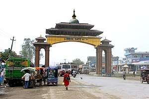
Siddharthanagar (formerly Bhairahawa) municipality is the administrative headquarter of Rupandehi District on the Outer Terai plains of Nepal, 265 km (165 mi) west of Kathmandu Nepal's capital. It is also the "Gateway of Lumbini." Lumbini, the birthplace of Gautama Buddha is 25 km to the west. Butwal is the nearest city around 21 km from Bhairahawa making the two major cities of the Butwal - Bhairahawa corridor. The city is among the major industrial power house in the country impacting major economic aspects of Nepal. It has the second largest rate of border trade with India after Birgunj border in the country. Bhairahawa is under the administration of Siddharthanagar Nagarpalika (municipality) so often known as Siddharthanagar.
Etymology
Bhairahawa was derived from the deity Bhairava a manifestation of Shiva. Siddharthanagar comes from the Buddha's given name "Siddhartha." Buddha was born near this city. Hence, the name Siddhartanagar was given by Komal Dutta Tiwari.
Climate
The highest temperature ever recorded in Siddharthanagar was 44.8 °C (112.6 °F) on the 7th June 1998, while the lowest temperature ever recorded was −1.1 °C (30.0 °F) on the 20th January 1971 .[1]
| Climate data for Siddharthanagar (Bhairahawa Airport) (1981-2010) | |||||||||||||
|---|---|---|---|---|---|---|---|---|---|---|---|---|---|
| Month | Jan | Feb | Mar | Apr | May | Jun | Jul | Aug | Sep | Oct | Nov | Dec | Year |
| Average high °C (°F) | 21.0 (69.8) |
25.4 (77.7) |
31.3 (88.3) |
36.1 (97) |
36.4 (97.5) |
35.5 (95.9) |
33.0 (91.4) |
33.4 (92.1) |
33.0 (91.4) |
32.2 (90) |
28.9 (84) |
24.1 (75.4) |
30.9 (87.6) |
| Daily mean °C (°F) | 14.9 (58.8) |
18.1 (64.6) |
23.0 (73.4) |
28.0 (82.4) |
30.0 (86) |
30.6 (87.1) |
29.5 (85.1) |
29.6 (85.3) |
28.8 (83.8) |
26.3 (79.3) |
21.7 (71.1) |
17.1 (62.8) |
24.8 (76.6) |
| Average low °C (°F) | 8.8 (47.8) |
10.7 (51.3) |
14.6 (58.3) |
19.9 (67.8) |
23.6 (74.5) |
25.7 (78.3) |
25.9 (78.6) |
25.9 (78.6) |
24.7 (76.5) |
20.3 (68.5) |
14.5 (58.1) |
10.2 (50.4) |
18.7 (65.7) |
| Average precipitation mm (inches) | 17.7 (0.697) |
19.2 (0.756) |
16.7 (0.657) |
26.4 (1.039) |
82.3 (3.24) |
269.4 (10.606) |
545.6 (21.48) |
395.5 (15.571) |
253.5 (9.98) |
77.5 (3.051) |
8.2 (0.323) |
13.3 (0.524) |
1,725.3 (67.925) |
| Source: Department Of Hydrology and Meteorology[2] | |||||||||||||
Demographics
The population of Siddarthanagar in 2001 was 63,528.[3] According to the 2011 census it was 163,483.
Economy
Siddharthnagar is a major trading city of Nepal.
There is a custom check point 5 km south near Indian border for the goods transport between India and Nepal.
Around Siddharthanagar, there are several small and large scale industries.
Bhairahawa Special Economic Zone was proposed to increase trade between Nepal and India. Government of Nepal has been encouraging different industries to establish their plant in the SEZ.
Transport
Siddharthanagar is connected with different cities of the country via roadways and air way. Direct flights are available to and from Kathmandu, the capital city. There are regular bus services to cities like Kathmandu, Pokhara, Dhangadhi, Biratnagar, Narayangadh and so on. Bus services include both day and night buses. Private vehicles are also available on hire to other cities. There is micro bus service to the nearest city Butwal every ten minutes.
Airport
Gautam Buddha Airport; 3 kilometers from the center—has daily flights to Kathmandu.It is being upgraded as a regional international airport.
Railway and taxi
There is no railway in this city. Only private taxis are operated in Bhairahawa city.
Hotels
There are some good hotels in Bhairahwa list as mentioned below:
- Tiger Palace Resort (Tilottama - 17, Rupandehi, Bhairahawa, Siddharthanagar, Nepal)
- Hotel Nirvana (Maitripath, Medical College Road, Siddharthanagar, 32900, Nepal )
- Hotel Yeti (Parasi Road, Siddharthanagar 32900, Nepal)
- Hotel Pawan International (Main Road, Siddharthanagar 32900, Nepal)
- Hotel Aakash (Siddhartha Hwy, Belahiya, Nepal)
- Hotel Lumbini International (Belahiya, Nepal)
- Hotel The White Lotus (Siddhartha Hwy, Siddharthanagar 32900, Nepal)
- Hotel Redsun (Balapur-Siddharthnagar)
- Hotel Lacaul (Sunauli road, Siddharthanagar 32900, Nepal
- Hotel Pauwa (Piparahiya Chowk, Siddharthanagar, 32900, Nepal
- Hotel Shree Shakya Buddha International" (Siddhartha Highway, Sonauli Road, Near Eye Hospital, Siddharthanagar 32900,Nepal)
Highway
Siddhartha Highway extends south to the Indian border at Sunauli and north through Butwal then into the hills through Tansen to Pokhara. In Butwal, this highway connects with the East-West Mahendra Rajmarg across the full expanse of the Nepalese Terai. There is regular long-distance bus and truck service to Kathmandu, Biratnagar, Birganj, Nepalganj, Pokhara and other cities in Nepal; also to Dehli, India via Gorakhpur and Sunauli taking 24–30 hours.
Local transport
Transportation options around the city and into surrounding areas include bus, minibus, unmetered taxicab and cycle rickshaw. There is regular bus service to Lumibini, Birthplace of Lord Buddha which lies in southern part of Siddharthanagar.
Immigration office
Border Crossing - Nepal has an open border where movement of Indian and Nepalese nationals concerned. There is a customs checkpoint for goods and third country nationals.
Non-profit organisations
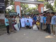
There are several NGOs are working in Bhairahawa. Terai Development Forum is one working for healthy, social and economic status of female, children and poor community by using local resources and increasing capability for their services and justifiable accession to the resources. FSC Rupandehi (Farmers Service Committee, Rupandehi) is the only a Non-profit organisation working for Farmers Families Development in Rupandehi and also supporting to others district by developing Non-profit organisation. Actually, more than 75% of total population are depending on Agro occupation In Siddharthanagar municipality also. Samriddhi Foundation is one which is working in education and health sectors.
FSC Rupandehi
This is a first Non-political / Non-Profit and Non-governmental organization for Real Farmers supporter NGO. Nepalese farmers are respected by Founder chairman of FSC Rupandehi, Mr. Dev Dhawal on 2070 Jesth 27 B.S. at ChhotakiRam Nager VDC (ChhotakiRam Nager Secondary School- field). So that's, Farmers Leader Dev Dhawal is know as Father / Founder of National Farmers Day in Nepal.
Educational organizations
- IAAS Paklihawa Campus
- Universal College of Medical Sciences
- Jaycees Kindergarten English Boarding Higher Secondary School
- Kashi Noble Academy
- Sun Shine Boarding Higher Secondary School

- Bhairahwa Multiple Campus
- Brihaspati College
- Buddha Jyoti College
- Paschimanchal English School
- Sai Global Academy
- Amar Jyoti English Medium School
- New Era English Medium School
- Moon Light English Boarding High School
- Minerva English Boarding high school
- C.b. public high school
- RETI Institute Pvt.ltd.
- The Next Education Consultancy Pvt Ltd.
- Nepal Nalanda Higher Secondary English Boarding School.
Media
Siddharthanagar has two FM radio stations:
- Rupandehi FM - 102 MHz, a community radio station
- Siddhartha FM - 98.8 MHz.
Culture
Hindus are in the majority, with a significant minority of Muslims and Buddhists associated with sites commemorating Gautama Buddha's life and relics. There is diversity in the culture as people from several part of country live here. Awadhi and Bhojpuri culture is native identity.
Cuisine
Awadhi cuisine is famous here. Foods like momo and panipuri are available street food. Sweets and desserts are quite popular. Besides stars restaurants, restaurants like Anchalpur Restaurant and party place, Bunu restaurant,Momo mantra & Hot Pizza restaurant, Pawan misthan, Kasturi restaurant, Pizza king and saambala restaurants, Redsun Resort etc. are famous at budget rates.
Health
- Bhim hospital (District Government Hospital), Bank Road
- Universal College of Medical Science Hospital (UCMS Hospital)
- Bhairahawa hospital, Naya Sadak
- Lumbini Eye Institute
- City Hospital
- Gautam Buddha Community Heart Hospital
- Meditech international hospital and research center
- Sri Krishna Netralaya
- Bijula Medical Hall
- Bhardwaj Herbal world [IMC]
Telecommunication
Major mobile service providers:
- Nepal Telecom - GSM/CDMA
- Ncell (P) Ltd - GSM
- United Telecom Limited - CDMA
- Smart Cell - GSM
For foreign citizens, document ID required - passport with valid visa. For Indian citizens - passport/Indian election card/Indian Embassy card.
Places of interest
- Lumbini Garden around Buddha's birthplace with monasteries representing nations. It is approximately 22 km (14 mi) from Siddharthanagar.
- Devadaha, an archeological site 15 km (9.3 mi) northeast near Khairhani village. The site is associated with the Koliyas, tribe of Lord Buddha's mother and one of eight tribes receiving corporeal relics after his death at Kushinagar.
- Ramagrama stupa, 20 km (12 mi) east of Siddharthanagar and 4 km (2.5 mi) south of Parasi in Nawalparasi District. There are emains of stupa and monastery on banks of Jahari River near Kerwani village. The stupa mound is approximately 10 m (33 ft) high and 20 m (66 ft) in diameter. Some suggest this was the center of the Koliya kingdom.
- Kapilvastu was the kingdom of the Shakyas, Buddha's (paternal) royal family. The administrative center of modern Kapilvastu District at Taulihawa is 40 km (25 mi) west of Siddharthanagar or 18 km (11 mi) beyond Lumbini. Many archaeological sites are within 10 km (6.2 mi) of Taulihawa. Local roads are in good condition.
- Tribeni Ghat on the Narayani River (known as Gandak in India) is an auspicious site for bathing. It attracts hundred thousands of pilgrims on Maghe Sankranti (Hindi: Makar Sankranti), approximately 15 January.
- Valmiki Ashram near Tribeni Ghat, believed to be the place where Prince Siddhartha got down from his horse Kantaka and strode off on foot and into the jungles in his search for answers.
- Chitwan National Park east of the Narayani River, a preserve larger than 900 km2 protecting some 700 native animal species—including gaur, tiger, rhioceros, gharial and crocodile—and flora native to the Terai-Duar savanna and grasslands.
- Meudihawa village which is situated on the southern part of Bhairahawa.[4]
2015 Nepal earthquake
The town shook in an earthquake on 25 April 2015. However, the town did not suffer much damage.[5] 3,400 people that were evacuated from Nepal by the government of Uttar Pradesh reached the Bhairahawa border with India in 44 buses.[6][7]
See also
References
- ↑ . Retrieved 27 February 2016.
- ↑ . Department Of Hydrology and Meteorology Retrieved 26 September 2014.
- ↑ Nepal - City Population - Cities, Towns & Provinces - Tables & Maps
- ↑ http://www.meudihawa.weebly.com
- ↑ Fan, Christina (28 April 2015). "Nepalese students in WV worried about family, friends". wowktv.com. wowktv.com. Archived from the original on 1 May 2015. Retrieved 30 May 2017.
- ↑ "UP Govt Evacuates Nearly 7000 from Nepal". Outlookindia. Outlookindia. 30 April 2015. Archived from the original on 1 May 2015. Retrieved 30 May 2017.
- ↑ "Nepal earthquake: Now country grappling with post-disaster diseases; 7000 Indians rescued so far". Newsnation.in. Newsnation.in. 30 April 2015. Archived from the original on 1 May 2015. Retrieved 30 May 2017.
External links
| Wikivoyage has a travel guide for Bhairahawa. |
Headquarter: Siddharthanagar | ||||||
| Urban |
|  | ||||
| Rural municipallity |
| |||||
List of municipalities and rural municipalities of Nepal | ||||||