Santiago, Ilocos Sur
| Santiago | ||
|---|---|---|
| Municipality | ||
| Municipality of Santiago | ||
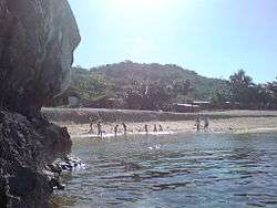 A beach in Ambucao | ||
| ||
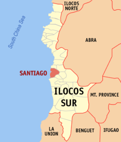 Map of Ilocos Sur with Santiago highlighted | ||
.svg.png) Santiago Location within the Philippines | ||
| Coordinates: 17°18′N 120°27′E / 17.3°N 120.45°ECoordinates: 17°18′N 120°27′E / 17.3°N 120.45°E | ||
| Country |
| |
| Region | Ilocos Region (Region I) | |
| Province | Ilocos Sur | |
| District | 2nd District | |
| Barangays | 24 (see Barangays) | |
| Government [1] | ||
| • Type | Sangguniang Bayan | |
| • Mayor | Josefino E. Miranda | |
| • Electorate | 11,481 voters (2016) | |
| Area [2] | ||
| • Total | 46.36 km2 (17.90 sq mi) | |
| Population (2015 census)[3] | ||
| • Total | 18,759 | |
| • Density | 400/km2 (1,000/sq mi) | |
| Time zone | UTC+8 (PST) | |
| ZIP code | 2707 | |
| PSGC | 012927000 | |
| IDD : area code | +63 (0)77 | |
| Climate type | Tropical monsoon climate | |
| Income class | 4th municipal income class | |
| Revenue (₱) | 290,583,630.45 (2016) | |
| Native languages |
Ilocano Tagalog | |

Santiago, officially the Municipality of Santiago, is a 4th class municipality in the province of Ilocos Sur, Philippines. According to the 2015 census, it has a population of 18,759 people.[3]
Santiago Cove is dubbed as the "Boracay of Ilocos Sur" because of its white sands.[4]
Santiago is the headquarters of the Ilocos Sur Electric Cooperative (ISECO), which distributes electricity to the entire province.
Santiago is 358 kilometres (222 mi) from Metro Manila and 49 kilometres (30 mi) from Vigan City, the provincial capital.
Barangays
Santiago is politically subdivided into 24 barangays. [2]
- Al-aludig
- Ambucao
- San Jose (Baraoas)
- Baybayabas
- Bigbiga
- Bulbulala
- Busel-busel
- Butol
- Caburao
- Dan-ar
- Gabao
- Guinabang
- Imus
- Lang-ayan
- Mambug
- Nalasin
- Olo-olo Norte
- Olo-olo Sur
- Poblacion Norte
- Poblacion Sur
- Sabangan
- Salincub
- San Roque
- Ubbog
History
Before the Spanish Conquest of the Philippines, Moro raiders were in control, so one of the tasks of the Spanish was to pacify and clear the country of these pirates. Coastal communities (Northern Luzon, and, thus, Ilocos) were prone to piratical attacks. For these, watchtowers were erected all over the Ilocos coast.
The Spanish started patrols of sea lanes, stopping these pirates for a while, only for them to resurface in 1772. But in the place now known as Santiago, as the Spanish engaged the pirates, all church bells ringing and trumpets sounded (to signal their attacks), the Augustinians stationed in the place held a statue of Santiago (Saint James) facing the sea and with many natives praying the rosary for safety and victory. The Moros fled, never to return, thus sparing the pueblo. The place was since then named Santiago.
It was once a visita of Narvacan due to the lack of ministers at the time.
Demographics
| Population census of Santiago | ||
|---|---|---|
| Year | Pop. | ±% p.a. |
| 1903 | 3,760 | — |
| 1918 | 5,429 | +2.48% |
| 1939 | 6,017 | +0.49% |
| 1948 | 6,610 | +1.05% |
| 1960 | 8,213 | +1.83% |
| 1970 | 10,224 | +2.21% |
| 1975 | 11,245 | +1.93% |
| 1980 | 11,843 | +1.04% |
| 1990 | 14,427 | +1.99% |
| 1995 | 14,843 | +0.53% |
| 2000 | 15,876 | +1.45% |
| 2007 | 16,806 | +0.79% |
| 2010 | 17,958 | +2.44% |
| 2015 | 18,759 | +0.83% |
| Source: Philippine Statistics Authority[3][5][6][7] | ||
In the 2015 census, the population of Santiago, Ilocos Sur, was 18,759 people,[3] with a density of 400 inhabitants per square kilometre or 1,000 inhabitants per square mile.
Image gallery
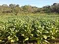 A field of tobacco growing in Baybayabas
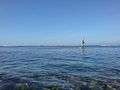 A man fishing just offshore near to Sabangan Beach.
References
- ↑ "Municipality". Quezon City, Philippines: Department of the Interior and Local Government. Retrieved 31 May 2013.
- 1 2 "Province: Ilocos Sur". PSGC Interactive. Quezon City, Philippines: Philippine Statistics Authority. Retrieved 12 November 2016.
- 1 2 3 4 Census of Population (2015). "Region I (Ilocos Region)". Total Population by Province, City, Municipality and Barangay. PSA. Retrieved 20 June 2016.
- ↑ "Sunrise at Santiago". Retrieved 14 January 2008.
- ↑ Census of Population and Housing (2010). "Region I (Ilocos Region)". Total Population by Province, City, Municipality and Barangay. NSO. Retrieved 29 June 2016.
- ↑ Censuses of Population (1903–2007). "Region I (Ilocos Region)". Table 1. Population Enumerated in Various Censuses by Province/Highly Urbanized City: 1903 to 2007. NSO.
- ↑ "Province of Ilocos Sur". Municipality Population Data. Local Water Utilities Administration Research Division. Retrieved 17 December 2016.
External links
- Pasyalang Ilocos Sur
- Philippine Standard Geographic Code
- Philippine Census Information
- Local Governance Performance Management System
Places adjacent to Santiago, Ilocos Sur | ||||||||||
|---|---|---|---|---|---|---|---|---|---|---|
| ||||||||||