San Nicolas, Ilocos Norte
| San Nicolas | ||
|---|---|---|
| Municipality | ||
| Municipality of San Nicolas | ||
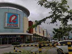 Robinsons Ilocos Norte | ||
| ||
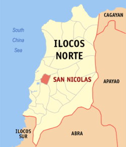 Map of Ilocos Norte with San Nicolas highlighted | ||
.svg.png) San Nicolas Location within the Philippines | ||
| Coordinates: 18°10′21″N 120°35′45″E / 18.1725°N 120.59583°ECoordinates: 18°10′21″N 120°35′45″E / 18.1725°N 120.59583°E | ||
| Country |
| |
| Region | Ilocos Region (Region I) | |
| Province | Ilocos Norte | |
| District | 2nd District | |
| Barangays | 24 (see Barangays) | |
| Government [1] | ||
| • Type | Sangguniang Bayan | |
| • Mayor | Alfredo P. Valdez Jr. | |
| • Electorate | 22,262 voters (2016) | |
| Area [2] | ||
| • Total | 40.18 km2 (15.51 sq mi) | |
| Population (2015 census)[3] | ||
| • Total | 36,736 | |
| • Density | 910/km2 (2,400/sq mi) | |
| Time zone | UTC+8 (PST) | |
| ZIP code | 2901 | |
| PSGC | 012820000 | |
| IDD : area code | +63 (0)77 | |
| Climate type | Tropical monsoon climate | |
| Income class | 2nd municipal income class | |
| Revenue (₱) | 143,379,358.85 (2016) | |
| Native languages |
Ilocano Tagalog | |
| Website |
www | |
San Nicolas (Ilocano: Ili ti San Nicolas; Filipino: Bayan ng San Nicolas), officially the Municipality of San Nicolas, is a 2nd class municipality in the province of Ilocos Norte, Philippines. According to the 2015 census, it has a population of 36,736 people.[3]
History
The present name of San Nicolas was given in the year 1733, after Saint Nicholas de Tolentino who was believed to have protected the people against floods, earthquakes, fires, typhoons and other calamities. It is significant that in Ilocos Norte, only San Nicolas was named after a Saint.
Like any other town in the ancient province of (Ilocos Province)San Nicolas was established by (Augustinian)missionaries. Vigan, the first Spanish mission center in this region, was founded in 1575. In the year 1572, when the Spaniards first explored the Laoag (Padsan) River, they met hostile resistance from the natives of San Nicolas and Laoag. In another expedition dispatched from Vigan in 1584 San Nicolas was established and Laoag followed a year later.
San Nicolas Catholic Church built in 1701 is one of the oldest buildings in this province. Its original structure is one of the must see places of the town. The Church and the attached Sta. Rosa Academy Building, the well preserved Municipal Hall and the old Town Plaza sprawled between them constitute the heart of the town center. These buildings and structures are originally built and continue to be festooned with earthen bricks, which is among the products of the surviving local.
Geography
San Nicolas is 484 kilometres (301 mi) from Metro Manila and 3 kilometres (1.9 mi) from Laoag City, the provincial capital.
Barangays
The Municipality of San Nicolas is politically divided into 24 barangays:
| Names of Barangay | Type | Brgy.No. | Local Names |
|---|---|---|---|
| San Agustin | Rural | 21 | Bugnay |
| San Baltazar | Urban | 2 | |
| San Bartolome | Urban | 4 | |
| San Cayetano | Urban | 12 | |
| San Eugenio | Urban | 13 | |
| San Fernando | Urban | 11 | |
| San Francisco | Urban | 1 | |
| San Gregorio | Urban | 14 | |
| San Guillermo | Rural | 22 | Catuguing |
| San Ildefonso | Urban | 3 | |
| San Jose | Urban | 15 | |
| San Juan Bautista | Urban | 6 | |
| San Lucas | Urban | 9 | |
| San Marcos | Rural | 16 | Payas |
| San Miguel | Urban | 7 | |
| San Pablo | Rural | 20 | |
| San Paulo | Urban | 10 | |
| San Pedro | Rural | 18 | Bingao |
| San Lorenzo | Rural | 19 | |
| Santa Monica | Rural | 24 | Nagrebcan |
| Santa Cecilia | Rural | 23 | Barabar |
| Santa Asuncion | Rural | 17 | Samac |
| San Silvestre | Urban | 5 | |
| San Rufino | Urban | 8 |
Profile of Barangays
- Barangay 1, San Francisco
- The first Malayan settlers were situated on the northern side of Brgy.1.This way besides the Rio Gaco,nowadays called Padsan(Laoag)River,where they could get water supply.But because of floods,the settlers move south and what is now Brgy.3.
- Barangay 2, San Baltazar
- In Spanish time, this barrio was named Navarra after a place in Spain.
- Barangay 3, San Ildefonso
- Named after Alfonso XII, a Spanish king.
- Barangay 4, San Bartolome
- Named Luzon after the biggest group of island,Luzon.
- Barangay 5, San Silvestre
- Named by the Spaniards Visayas.
- Barangay 6, San Juan Bautista
- Named Mindanao.
- Barangay 7, San Miguel
- Named by the Spaniards Filipinas because it is situated in the east of the Pueblo, noting that the Philippines is on the east side of the globe.
- Barangay 8, San Rufino
- In line with its Economic Program Pottery was introduced by the Spanish Authorities. It soon became a Pilot Center where people from different barangays took lessons in Pottery. Hence, it was called "Alfareria" means "Art of Pottery".
- Barangay 9, San Lucas
- Also known as Cabugnayan and Capitacan. During the early part of the 18th century, areas of San Nicolas were still wilderness and there was not a single road leading to this place. Unfriendly Tinggians and Igorots lived in these places and people in the poblacion avoided them.
- Barangay 10, San Paulo
- Also known as Pamitacan from the word Pitak or mud, because its muddy when it rains.
- Barangay 11, San Fernando
- Located along the McArthur Highway and bordered between Barangays 10, 12, 3 and 22.
- Barangay 12, San Cayetano
- Located next to Barangay 11
- Barangay 13, San Eugenio
- Located next to Barangay 12 and has a little rice fields situated in its area.
- Barangay 14, San Gregorio
- Situated in the south of Barangay 15. It is the home to Eladio Barangan Elementary School.
- Barangay 15, San Jose
- Its here we can find the cemetery (also in Brgy.1) and the Gertes Hospital.
- Barangay 16, San Marcos
- Locally known as Payas.
- Barangay 17, Santa Asuncion
- Known as Samac. It can be reach via Payas Road or by Brgy.18.
- Barangay 18, San Pedro
- Southern most (eastern portion) barangay of San Nicolas. Known as Bingao meaning "Art of Burning".
- Barangay 19, San Lorenzo
- Lies in the north of Bingao.
- Barangay 20, San Pablo
- Southern most (western portion) of San Nicolas.
- Barangay 21, San Agustin
- Known as Bugnay and where the Venvi is situated.
- Barangay 22, San Guillermo
- Known as Catuguing because of its many tuguis or kamoteng kahoy.
- Barangay 23, Santa Cecilia
- Known as Barabar.
- Barangay 24, Santa Monica
- known as Nagrebcan. It is also known as Daan nga Ili.
Climate
San Nicolas has a tropical savanna climate with warm to hot temperatures year round. Temperatures dips sightly during the winter months between December to February.
| Climate data for San Nicolas | |||||||||||||
|---|---|---|---|---|---|---|---|---|---|---|---|---|---|
| Month | Jan | Feb | Mar | Apr | May | Jun | Jul | Aug | Sep | Oct | Nov | Dec | Year |
| Average high °C (°F) | 30.0 (86) |
30.8 (87.4) |
32.0 (89.6) |
33.4 (92.1) |
33.8 (92.8) |
32.5 (90.5) |
31.8 (89.2) |
31.0 (87.8) |
31.3 (88.3) |
31.9 (89.4) |
31.2 (88.2) |
30.5 (86.9) |
31.7 (89) |
| Daily mean °C (°F) | 24.4 (75.9) |
25.0 (77) |
26.5 (79.7) |
28.2 (82.8) |
29.1 (84.4) |
28.4 (83.1) |
27.8 (82) |
27.4 (81.3) |
27.5 (81.5) |
27.4 (81.3) |
26.5 (79.7) |
25.4 (77.7) |
27 (80.5) |
| Average low °C (°F) | 18.8 (65.8) |
19.2 (66.6) |
20.9 (69.6) |
23.1 (73.6) |
24.4 (75.9) |
24.3 (75.7) |
24.0 (75.2) |
23.9 (75) |
23.6 (74.5) |
22.9 (73.2) |
21.9 (71.4) |
20.2 (68.4) |
22.3 (72.1) |
| Average rainfall mm (inches) | 11.8 (0.465) |
1.1 (0.043) |
2.5 (0.098) |
19.8 (0.78) |
125.1 (4.925) |
376.8 (14.835) |
386.4 (15.213) |
547.3 (21.547) |
324.1 (12.76) |
86.1 (3.39) |
45.1 (1.776) |
10.2 (0.402) |
1,936.3 (76.234) |
| Average rainy days | 1 | 1 | 1 | 2 | 8 | 15 | 17 | 20 | 15 | 8 | 5 | 2 | 95 |
| Source: PAG-ASA[4] | |||||||||||||
Demographics
| Population census of San Nicolas | ||
|---|---|---|
| Year | Pop. | ±% p.a. |
| 1903 | 10,880 | — |
| 1918 | 12,244 | +0.79% |
| 1939 | 13,958 | +0.63% |
| 1948 | 15,567 | +1.22% |
| 1960 | 17,721 | +1.09% |
| 1970 | 20,182 | +1.31% |
| 1975 | 22,175 | +1.91% |
| 1980 | 23,384 | +1.07% |
| 1990 | 27,632 | +1.68% |
| 1995 | 29,083 | +0.96% |
| 2000 | 31,688 | +1.86% |
| 2007 | 33,642 | +0.83% |
| 2010 | 34,237 | +0.64% |
| 2015 | 36,736 | +1.35% |
| Source: Philippine Statistics Authority[3][5][6][7] | ||
In the 2015 census, the population of San Nicolas, Ilocos Norte, was 36,736 people,[3] with a density of 910 inhabitants per square kilometre or 2,400 inhabitants per square mile.
Religion
Christianity is the predominant religion in the Philippines and is likewise the same in San Nicolas. Among the Christian denominations, the Catholic and Philippine Independent Churches make up the majority. Other Christian denominations represented in the town include Baptists, Pentecostals, Mormons, Charismatics and Jehovah's Witnesses. Below are the religious building situated in San Nicolas:
- Calvary Baptist Church (Brgy. 14)
- Everlasting Baptist Church (Brgy. 15)
- Free Gospel Church (Brgy. 2)
- Kingdom Hall of Jehovah's Witnesses (Brgy.2)
- Saint Nicholas de Tolentino Parish Church (Brgy.3)
- Iglesia Filipina Independiente (Brgy.3)
- Church of Jesus Latter-Day Saints (Brgy.2)
- Church of Jesus Latter-Day Saints (Brgy.21)
- Iglesia ni Cristo (Brgy.1)
- Jesus is Lord (Brgy.12)
Economy
Pottery making is the main trademark of San Nicolas. It was introduced by the Spaniards mainly in Brgy. 8, and they called it Alfareria, meaning "Art of Pottery". Other traditional crafts include the making of Tagapulot, Lapida, Chicharon and Longganisa. The town also has a large ricefields.
San Nicolas is known for its car stores and sales. In Ilocos Norte, San Nicolas is the only one who has new car dealers. There are also many businesses inside Robinson's Mall and SM Save More.
Local government
Municipal Mayor: Alfredo P. Valdez, Jr.
Municipal Vice Mayor: Edistio P. Valdez
Municipal Councilors:
- Angel Miguel L. Hernando
- Domingo C. Ambrocio, Jr.
- Ariel B. Villa
- Efren C. Butay
- Norberto S. Dadiz, Jr.
- Manuel D. Coloma
- Orlando B. Badua
- Jessie P. Pumaras
ABC President: Linda Badua
Government seal
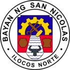
Shield, derived from the Provincial Seal of Ilocos Norte
Gear, symbolizes the systematic livelihood of the people of San Nicolas, Ilocos Norte
Tong and Hammer, represents the blacksmithing and labor
Jar, signifies the pottery industry which dates back to the Spanish time
Hide, denotes tannoing and leather craft
Water, represents the irrigation system that produces two croppings a year
Carabao Head, the common work-animal; friend of the farmer; symbolizes agriculture
Attractions
San Nicolas is a place of historic buildings. Examples are San Nicolas de Tolentino Parish Church and San Nicolas Municipal Hall.
- Damili Festival- A festival annually celebrated at the last week of December to showcase the tradition of San Nicolenos. And the highlights of the festival is the Damili Street Daance and Showdown Competition usually held every December 28.
- Valdez Center-The biggest project of Venvi Group of Companies. Robinsons Mall, 365 Plaza, Freddo, Balai Condominium, and McDonald's San Nicolas, Venvi IT Park (Accenrture, a BPO Company), VYV San Nicolas (EGS, a BPO Company) are situated here. More infrastructure is seen to rise in this place. this is the center of business in San Nicolas and also business center of Ilocos Norte.
- Robinsons Ilocos Norte -The first full-operating mall in the province, was built in San Nicolas, Ilocos Norte. Opening last December 3, 2009, it makes a good income to the town and the province. Last December 18, 2012 the mall expansion was announced.
- Northwestern University Ecotourism Park and Botanical Gardens-A member of the Botanic Garden Conservation International (BGCI), which caters to the conservation of important indigenous plant species of the province which are now on the verge of extinction.
- St. Nicholas de Tolentino Parish Church
- San Nicolas Town Plaza
- Buabo-Buabo
- Valdes Residencia
- Valdez-Lardizabal House - used in World War II as a Headquarters of the Japanese Army and also used in the American Regime.
- San Nicolas Municipal Hall
Schools
High Schools
- San Nicolas National High School (SNNHS) - is the most popular high school destination for teens living in the urban-part of the town. It is also the most populated school in San Nicolas. As of S.Y. 2015-2016 the school's attendance is than 1,500 of students. The school offers various curriculum. (Special Science Curriculum, SPA, Open High, SPED, and Regular)
- Bingao National High School - formerly SNNHS Bingao Campus. But last June 9, 2015,the school was announced to be a different school from SNNHS.
- Sta. Rosa Academy - the least populated school in San Nicolas and town's only private and Catholic School. Named after St. Rose of Lima, the patron saint of one of its founders. It is one of the oldest schools in the Diocese of Laoag. It was established in 1936 by the late Msgr. Fidel Albano, together with the late Miss Rosa Valdes, Mrs. Teresa Llopis Zabala and Miss Castora Bonoan.
Elementary Schools
- San Nicolas Elementary School - also known as Central School, located at Brgy.3.
- Eladio V. Barangan Memorial Elementary School - Located at Brgy.14
- Cayetano Bumanglag Memorial Elementary School - Formerly Payas Elementary School, located at Brgy.16
- Catuguing Elementary School - Located at Brgy.22
- Asuncion Elementary School - Located at Brgy.17
- Bugnay Elementary School - Located at Brgy.21
- Bingao Elementary School - Located at Brgy.18
- Filipinas East Elementary School - Formerly Filipinas Elementary School-Main Campus and located at Brgy.7 (East)
- Filipnas West Elementary School - Formerly Filipinas Elementary School-Annex Campus and located at Brgy.7 (West)
- Pasion Barangan Memorial Elementary School - Located at Brgy.24
- Barabar Elementary School - Located at Brgy.23
Health facilities
- The Black Nazarene Hospital, Inc - located in Brgy. 2
- Municipal Health Center - located in Brgy. 3
- Gertes Hospital - located in Brgy. 15
- Mamaclay Clinic - located in Brgy. 7
Sports
Basketball is widely played in the town.Every year,there is a competition in Basketball sponsored by the local government.As the countries' National Game, Sepak Takraw is also played.Volleyball,Baseball,Softball and Badminton is also played mainly in schools.
Sister Cities
References
- ↑ "Municipality". Quezon City, Philippines: Department of the Interior and Local Government. Retrieved 31 May 2013.
- ↑ "Province: Ilocos Norte". PSGC Interactive. Quezon City, Philippines: Philippine Statistics Authority. Retrieved 12 November 2016.
- 1 2 3 4 Census of Population (2015). "Region I (Ilocos Region)". Total Population by Province, City, Municipality and Barangay. PSA. Retrieved 20 June 2016.
- ↑ "Climatic Normals of the Philippines (1951-1985) (PAGASA 1987)" (PDF). PAGASSA. Retrieved 25 October 2014.
- ↑ Census of Population and Housing (2010). "Region I (Ilocos Region)". Total Population by Province, City, Municipality and Barangay. NSO. Retrieved 29 June 2016.
- ↑ Censuses of Population (1903–2007). "Region I (Ilocos Region)". Table 1. Population Enumerated in Various Censuses by Province/Highly Urbanized City: 1903 to 2007. NSO.
- ↑ "Province of Ilocos Norte". Municipality Population Data. Local Water Utilities Administration Research Division. Retrieved 17 December 2016.
External links
| Wikimedia Commons has media related to San Nicolas, Ilocos Norte. |