Luna, La Union
| Luna | ||
|---|---|---|
| Municipality | ||
| Municipality of Luna | ||
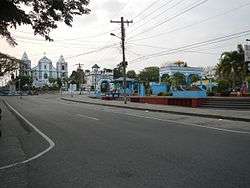 Luna town center overlooking the Santa Catalina de Alejandria Church | ||
| ||
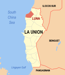 Map of La Union with Luna highlighted | ||
.svg.png) Luna Location within the Philippines | ||
| Coordinates: 16°51′N 120°23′E / 16.85°N 120.38°ECoordinates: 16°51′N 120°23′E / 16.85°N 120.38°E | ||
| Country |
| |
| Region | Ilocos Region (Region I) | |
| Province | La Union | |
| District | 1st District | |
| Barangays | 40 (see Barangays) | |
| Government [1] | ||
| • Type | Sangguniang Bayan | |
| • Mayor | Victor Marvin U. Marron | |
| • Electorate | 21,106 voters (2016) | |
| Area [2] | ||
| • Total | 42.90 km2 (16.56 sq mi) | |
| Population (2015 census)[3] | ||
| • Total | 35,802 | |
| • Density | 830/km2 (2,200/sq mi) | |
| Time zone | UTC+8 (PST) | |
| ZIP code | 2518 | |
| PSGC | 013310000 | |
| IDD : area code | +63 (0)72 | |
| Climate type | Tropical monsoon climate | |
| Income class | 3rd municipal income class | |
| Revenue (₱) | 110,465,313.37 (2016) | |
| Native languages |
Ilocano Tagalog | |
| Website |
www | |

Luna, officially the Municipality of Luna, is a 3rd class municipality in the province of La Union, Philippines. According to the 2015 census, it has a population of 35,802 people.[3]
Barangays
Luna is politically subdivided into 40 barangays. [2]
- Alcala
- Ayaoan
- Barangobong
- Barrientos
- Bungro
- Busel-Busel
- Cabalitocan
- Cantoria No. 1
- Cantoria No. 2
- Cantoria No. 3
- Cantoria No. 4
- Carisquis
- Darigayos
- Magallanes
- Magsiping
- Mamay
- Nagrebcan
- Nalvo Norte
- Nalvo Sur
- Napaset
- Oaqui No. 1
- Oaqui No. 2
- Oaqui No. 3
- Oaqui No. 4
- Pila
- Pitpitac
- Rimos No. 1
- Rimos No. 2
- Rimos No. 3
- Rimos No. 4
- Rimos No. 5
- Rissing
- Salcedo
- Santo Domingo Norte
- Santo Domingo Sur
- Sucoc Norte
- Sucoc Sur
- Suyo
- Tallaoen
- Victoria
Luna's poblacion (town center) consists of the four barangays: Victoria, Salcedo, Alcala, and Magallanes.
History
Luna was once called Namacpacan, which is an Ilocano word meaning "one who feeds".
As early as 1587, Namacpacan was recorded as a visita (satellite mission, whose church is manned by non-resident clergy based in the cabecera) of Purao (now Balaoan). It was a settlement along the camino real (national road) from Vigan to Manila, and travellers stopped there to refresh themselves. Since restaurants was not yet in vogue, local families offered the travellers food and lodging, hence the name.
On 18 October 1906, during the terms of Governor Joaquin Luna and Mayor Primitivo Resurrección Novicio, the town was renamed "Luna" through Philippine Commission Act No. 1543. It was the first town that altered its name since the creation of the province in 1850. The change was to honour the famous Luna brothers: Revolutionary General Antonio and Spoliarium painter Juan; their mother, Doña Laureana Novicio Luna, was a native of Namacpacan.
Demographics
| Population census of Luna | ||
|---|---|---|
| Year | Pop. | ±% p.a. |
| 1903 | 11,116 | — |
| 1918 | 13,542 | +1.32% |
| 1939 | 14,624 | +0.37% |
| 1948 | 17,258 | +1.86% |
| 1960 | 18,595 | +0.62% |
| 1970 | 22,767 | +2.04% |
| 1975 | 24,065 | +1.12% |
| 1980 | 25,081 | +0.83% |
| 1990 | 28,308 | +1.22% |
| 1995 | 29,974 | +1.08% |
| 2000 | 32,259 | +1.59% |
| 2007 | 35,372 | +1.28% |
| 2010 | 35,380 | +0.01% |
| 2015 | 35,802 | +0.23% |
| Source: Philippine Statistics Authority[3][4][5][6] | ||
In the 2015 census, the population of Luna, La Union, was 35,802 people,[3] with a density of 830 inhabitants per square kilometre or 2,100 inhabitants per square mile.
Tourist attractions
_of_Luna.JPG)
Luna is also known for its beaches, particularly in Nalvo Sur and Darigayos. Beach shades, cottages and resorts are found in these barangays. The municipality is also known for its native delicacies and pottery products which are comparable to San Juan's.
The town is a pilgrimage site as it enshrines the Apo Baket Namacpacan, a wooden Marian image.
On the beach of barangay Victoria rests the ruins of an old Spanish watch tower, locally named as Balauarte. The tower was intended to guard the shores of the town primarily from Muslim and pirate attacks during the Spanish period. During World War II, the tower served as the communication tower post for a temporary airfield for the USAFIP-NL forces. Due to years of quarrying within the site of the tower (1980 to 2000), the coastline receded and sea waves severely damaged the foundation of the tower, which eventually caused major damage to its structure. At present, efforts were initiated to preserve the tower from further damage.
Education
Luna has Public Elementary schools in each barangay. There are 6 public high schools (Luna National Science High School - Central in Barangay Barrientos, LNHS - Rimos and Cantoria Annex; and Oanari National High School) Bungro-Sucoc Integrated School in Bungro, Luna Technical Vocational High School and 1 Private High School (Santa Catalina Academy).
Gallery
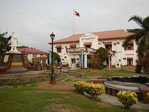 Municipal hall
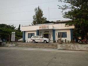 Police station
 Town center
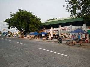 Luna Sports Center
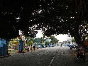 Street view
References
- ↑ "Municipality". Quezon City, Philippines: Department of the Interior and Local Government. Retrieved 31 May 2013.
- 1 2 "Province: La Union". PSGC Interactive. Quezon City, Philippines: Philippine Statistics Authority. Retrieved 12 November 2016.
- 1 2 3 4 Census of Population (2015). "Region I (Ilocos Region)". Total Population by Province, City, Municipality and Barangay. PSA. Retrieved 20 June 2016.
- ↑ Census of Population and Housing (2010). "Region I (Ilocos Region)". Total Population by Province, City, Municipality and Barangay. NSO. Retrieved 29 June 2016.
- ↑ Censuses of Population (1903–2007). "Region I (Ilocos Region)". Table 1. Population Enumerated in Various Censuses by Province/Highly Urbanized City: 1903 to 2007. NSO.
- ↑ "Province of La Union". Municipality Population Data. Local Water Utilities Administration Research Division. Retrieved 17 December 2016.
External links
| Wikimedia Commons has media related to Luna, La Union. |
- Philippine Standard Geographic Code
- Philippine Census Information
- Local Governance Performance Management System
Places adjacent to Luna, La Union | |
|---|---|