Ilfjellet
| Ilfjellet | |
|---|---|
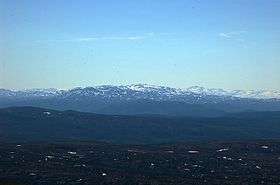 Ilfjellet seen from Kråkfjellet (north east) | |
| Highest point | |
| Elevation | 1,218 m (3,996 ft) |
| Prominence | 790 m (2,590 ft) |
| Coordinates | 62°56′44″N 9°56′29″E / 62.9456°N 09.9414°ECoordinates: 62°56′44″N 9°56′29″E / 62.9456°N 09.9414°E [1] |
| Geography | |
 Ilfjellet Location of the mountain  Ilfjellet Ilfjellet (Norway) | |
| Location | Trøndelag, Norway |
| Topo map | 1520 I Rennebu |
Ilfjellet is a mountain in the municipality of Rennebu in Trøndelag county, Norway. It is located in the northeastern part of the municipality, about 13 kilometres (8.1 mi) north of the municipal center of Berkåk and 10 kilometres (6.2 mi) southeast of Å in neighboring Meldal municipality. The mountain is 1,218 metres (3,996 ft) tall.[2]
Name
The mountain is named after the river Ila. The last element is the finite form of fjell which means "fell" or "mountain". The river name is derived from Old Norse íla which means "spring".
References
- ↑ "Ilfjellet, Rennebu (Trøndelag)" (in Norwegian). yr.no. Retrieved 2018-01-25.
- ↑ Store norske leksikon. "Ilfjellet" (in Norwegian). Retrieved 2011-02-02.
This article is issued from
Wikipedia.
The text is licensed under Creative Commons - Attribution - Sharealike.
Additional terms may apply for the media files.