Raton Pass
| Ratón Pass | |
|---|---|
 Amtrak's Southwest Chief westbound out of the Raton Tunnel near the summit of Raton Pass | |
| Elevation | 7,834 ft (2,388 m) |
| Traversed by |
Burlington Northern Santa Fe Railroad |
| Location | Colfax County, New Mexico and Las Animas County, Colorado, US |
| Coordinates | 36°59′28″N 104°29′12″W / 36.9911344°N 104.4866544°WCoordinates: 36°59′28″N 104°29′12″W / 36.9911344°N 104.4866544°W[1] |
| Topo map |
Ratón |
|
Raton Pass | |
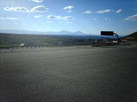 Looking into Colorado from Raton Pass | |
| Nearest city | Trinidad, Colorado, Raton, New Mexico |
| Area | 1,520 acres (620 ha) |
| Built | 1866 |
| NRHP reference # | 66000474[2] |
| CSRHP # | 5LA.2182[3] |
| Significant dates | |
| Added to NRHP | October 15, 1966 |
| Designated NHL | December 19, 1960[4] |
  | |
Ratón Pass is a 7,834 ft (2,388 m) elevation mountain pass on the Colorado-New Mexico border in the western United States. Ratón is Spanish for "mouse". It is located on the eastern side of the Sangre de Cristo Mountains between Trinidad, Colorado and Raton, New Mexico, approximately 100 miles (160 km) northeast of Santa Fe. The pass crosses the line of volcanic mesas that extends east from the Sangre de Cristo Mountains along the state line, and furnishes the most direct land route between the valley of the Arkansas River to the north and the upper valley of the Canadian River, leading to Santa Fe, to the south. The pass now carries Interstate 25 and railroad tracks.
The pass is a historically significant landmark on the Santa Fe Trail, a major 19th-century settlement route between Kansas City, Missouri and Santa Fe. It was designated a National Historic Landmark in 1960 for this association.
History
In 1821, Captain William Becknell laid the path of the Santa Fe Trail through the pass. In 1846 during the Mexican–American War, Stephen W. Kearny and his troops passed through the pass en route to New Mexico. During the Civil War, it was the primary path into New Mexico since it avoided Confederate raiders.[4] It was later developed into a toll road by Richens Lacey Wootton.
Railroad route
In the late 19th century, it was used by the Atchison, Topeka and Santa Fe Railway as the railroad's primary route through the mountains. Along with the Royal Gorge in Colorado the pass was one of the focal points for the 1878–1879 Railroad Wars between the AT&SF and the smaller Denver and Rio Grande Railroad. The route over the pass required gradients of up to 3.5%, with a tunnel at the highest point of the AT&SF, at 7588 feet above sea level. The tunnel is entirely within New Mexico, with its northern portal only a few feet south of the Colorado border.[5]
BNSF Railway, which absorbed the Santa Fe railroad in 1996, and Amtrak continue to use this route. However, following completion of the Belen Cutoff in 1908, the majority of freight traffic was diverted over the Cutoff, which has gradients of no more than 1.25%. Amtrak's Southwest Chief passenger service between Chicago and Los Angeles, continues to use Raton Pass (one train daily in each direction). In 2012, there was not enough freight traffic for BNSF to maintain the line up to the standards required by Amtrak for continued intercity service. This problem has placed the future of rail transportation over Raton Pass in jeopardy.[6] As of 2012 BNSF operates little to no revenue freight service over the pass between La Junta, Colorado, and Lamy, New Mexico, leaving Amtrak's Southwest Chief as the only daily revenue train to occupy the route.
Highway route
In the 20th century the Pass became the route of U.S. Route 85 and later Interstate 25 between Denver and Albuquerque. The road at the pass is at an elevation of 7834 feet above sea level, and therefore is subject to difficult driving and occasional closure during heavy winter snowfalls.
In popular culture
The pass was part of a Townes Van Zandt song "Snowin' on Raton". During a live performance, Townes commented how he liked playing a show in Colorado because he didn't have to explain what Raton was.
Raton Pass is mentioned in C. W. McCall's (Bill Fries) song "Four Wheel Cowboy", from his album Wilderness. "Four Wheel Cowboy" also appears on his compilation release, titled "The Best of C. W. McCall".
Clint Black makes reference to the Raton Pass in the song "The Goodnight-Loving" from the album "Put Yourself in My Shoes."
- Ridin' against the wind in east New Mexico,
- His skin is dry and worn as the Texas plains.
- He's headed where the air is thin and the cold blue northers blow,
- Up through the Raton Pass, but he'll have to beat the early snow,[7]
Gallery
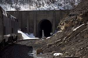 Amtrak's Southwest Chief entering the north end of the tunnel
 Sign marking the elevation of the Raton Pass tunnel
See also
References
- ↑ "Ratón Pass". Geographic Names Information System. United States Geological Survey. Retrieved 2010-01-03.
- ↑ National Park Service (2010-07-09). "National Register Information System". National Register of Historic Places. National Park Service.
- ↑ "State Register of Historic Properties, Las Animas County". Office of Archaeology and Historic Preservation. Retrieved December 9, 2016.
- 1 2 "Raton Pass". National Historic Landmark summary listing. National Park Service. Archived from the original on 2011-06-06. Retrieved 2007-10-13.
- ↑ Harper, Jared V. "Santa Fe's Raton Pass". (1983, Kachina Press). ISBN 0930724097.
- ↑ Colorado State Legislature, Preserve & Expand Amtrak Interstate Rail Service p2 Section 1(b)(c)
- ↑ Black, Clint. "The Goodnight Lovin'". CowboyLyrics.com. Retrieved 19 September 2014.
External links
| Wikimedia Commons has media related to Raton Pass. |
- Raton Tunnel
- “Glorieta and Raton Passes: Gateways to the Southwest”, a National Park Service Teaching with Historic Places (TwHP) lesson plan
- Raton Line: The Original Santa Fe Transcontinental, a railroad history of Raton Pass
| Topics | |
|---|---|
| Lists by states |
|
| Lists by insular areas | |
| Lists by associated states | |
| Other areas | |
| |

Santa Fe (capital) | ||
| Topics |
| |
| Society | ||
| Regions |
| |
| Cities | ||
| Counties | ||