Saguache County, Colorado
| Saguache County, Colorado | ||
|---|---|---|
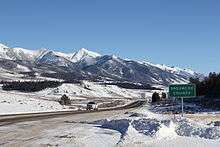 Entering Saguache County from the north on U.S. 285 | ||
| ||
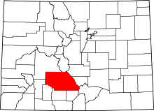 Location in the U.S. state of Colorado | ||
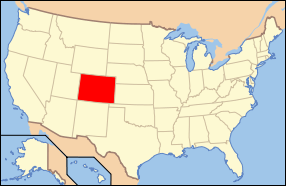 Colorado's location in the U.S. | ||
| Founded | December 29, 1866 | |
| Seat | Saguache | |
| Largest town | Center | |
| Area | ||
| • Total | 3,170 sq mi (8,210 km2) | |
| • Land | 3,169 sq mi (8,208 km2) | |
| • Water | 1.7 sq mi (4 km2), 0.05% | |
| Population (est.) | ||
| • (2015) | 6,251 | |
| • Density | 1.9/sq mi (0.7/km2) | |
| Congressional district | 3rd | |
| Time zone | Mountain: UTC−7/−6 | |
| Website |
www | |

Saguache County /səˈwɑːtʃ/ (![]()
History
Saguache County was formed December 29, 1866 in the Territory of Colorado when it was extracted from the northern half of Costilla County. A later partition from Lake County in February 9, 1872 added the northwest section of the present-day county.
Geography
According to the U.S. Census Bureau, the county has a total area of 3,170 square miles (8,200 km2), of which 3,169 square miles (8,210 km2) is land and 1.7 square miles (4.4 km2) (0.05%) is water.[6] It is the 7th largest of Colorado's 64 counties.
Adjacent counties
- Chaffee County - north
- Fremont County - northeast
- Custer County - east
- Huerfano County - southeast
- Rio Grande County - south
- Alamosa County - south
- Mineral County - southwest
- Hinsdale County - southwest
- Gunnison County - northwest
National protected areas
Trails and byways
- Colorado Trail
- Continental Divide National Scenic Trail
- Great Parks Bicycle Route
- Liberty Road historic mail route open to foot, horse, and bicycle travel between Crestone and the ghost towns of Duncan and Liberty crossing the Baca Mountain Tract Rio Grande National Forest.[7]
- Medano Pass Primitive Road
- Montville Nature Trail
- Mosca Pass Trail
- Old Spanish National Historic Trail
- Sand Ramp Trail, a hiking trail within the Great Sand Dunes National Park and Preserve which skirts the east and north of the dune field.[8]
- Western Express Bicycle Route
Demographics
| Historical population | |||
|---|---|---|---|
| Census | Pop. | %± | |
| 1870 | 304 | — | |
| 1880 | 1,973 | 549.0% | |
| 1890 | 3,313 | 67.9% | |
| 1900 | 3,853 | 16.3% | |
| 1910 | 4,160 | 8.0% | |
| 1920 | 4,638 | 11.5% | |
| 1930 | 6,250 | 34.8% | |
| 1940 | 6,173 | −1.2% | |
| 1950 | 5,664 | −8.2% | |
| 1960 | 4,473 | −21.0% | |
| 1970 | 3,827 | −14.4% | |
| 1980 | 3,935 | 2.8% | |
| 1990 | 4,619 | 17.4% | |
| 2000 | 5,917 | 28.1% | |
| 2010 | 6,108 | 3.2% | |
| Est. 2016 | 6,389 | [9] | 4.6% |
| U.S. Decennial Census[10] 1790-1960[11] 1900-1990[12] 1990-2000[13] 2010-2015[4] | |||
As of the census[14] of 2000, there were 5,917 people, 2,300 households, and 1,557 families residing in the county. The population density was 2 people per square mile (1/km²). There were 3,087 housing units at an average density of 1 per square mile (0/km²). The racial makeup of the county was 71.29% White, 0.12% Black or African American, 2.06% Native American, 0.46% Asian, 23.00% from other races, and 3.08% from two or more races. 45.26% of the population were Hispanic or Latino of any race.
There were 2,300 households out of which 33.40% had children under the age of 18 living with them, 52.70% were married couples living together, 11.00% had a female householder with no husband present, and 32.30% were non-families. 26.90% of all households were made up of individuals and 7.70% had someone living alone who was 65 years of age or older. The average household size was 2.56 and the average family size was 3.15.
In the county, the population was spread out with 28.40% under the age of 18, 7.90% from 18 to 24, 26.00% from 25 to 44, 26.90% from 45 to 64, and 10.80% who were 65 years of age or older. The median age was 37 years. For every 100 females there were 101.70 males. For every 100 females age 18 and over, there were 99.70 males.
The median income for a household in the county was $25,495, and the median income for a family was $29,405. Males had a median income of $25,158 versus $18,862 for females. The per capita income for the county was $13,121. About 18.70% of families and 22.60% of the population were below the poverty line, including 27.60% of those under age 18 and 12.50% of those age 65 or over.
Politics
| Year | Republican | Democratic | Others |
|---|---|---|---|
| 2016 | 40.5% 1,147 | 50.0% 1,417 | 9.6% 271 |
| 2012 | 32.9% 964 | 63.6% 1,865 | 3.5% 103 |
| 2008 | 34.8% 956 | 62.9% 1,730 | 2.3% 64 |
| 2004 | 41.5% 1,163 | 56.9% 1,594 | 1.6% 46 |
| 2000 | 42.6% 1,078 | 45.3% 1,145 | 12.1% 306 |
| 1996 | 36.5% 712 | 49.6% 969 | 13.9% 271 |
| 1992 | 31.1% 675 | 46.5% 1,011 | 22.5% 488 |
| 1988 | 46.9% 945 | 51.3% 1,033 | 1.7% 35 |
| 1984 | 57.6% 1,201 | 41.6% 867 | 0.8% 16 |
| 1980 | 52.7% 1,124 | 41.8% 893 | 5.5% 118 |
| 1976 | 49.5% 1,094 | 47.9% 1,059 | 2.6% 57 |
| 1972 | 63.2% 1,062 | 34.4% 578 | 2.4% 41 |
| 1968 | 52.5% 824 | 41.3% 648 | 6.3% 99 |
| 1964 | 36.1% 622 | 63.7% 1,099 | 0.2% 4 |
| 1960 | 49.1% 956 | 50.5% 984 | 0.5% 9 |
| 1956 | 58.0% 1,149 | 41.6% 823 | 0.4% 8 |
| 1952 | 65.1% 1,344 | 34.6% 714 | 0.3% 7 |
| 1948 | 47.2% 914 | 52.1% 1,009 | 0.7% 14 |
| 1944 | 62.1% 1,204 | 37.6% 729 | 0.3% 5 |
| 1940 | 55.6% 1,462 | 43.4% 1,142 | 1.0% 27 |
| 1936 | 43.8% 1,071 | 54.0% 1,321 | 2.2% 54 |
| 1932 | 37.9% 931 | 58.1% 1,427 | 4.1% 100 |
| 1928 | 62.6% 1,491 | 35.9% 854 | 1.5% 36 |
| 1924 | 58.3% 1,205 | 28.6% 591 | 13.1% 270 |
| 1920 | 60.3% 1,195 | 36.2% 717 | 3.5% 69 |
| 1916 | 34.2% 681 | 63.0% 1,254 | 2.8% 55 |
| 1912 | 36.4% 730 | 42.8% 859 | 20.8% 418 |
Communities
National Register of Historic Places
Saguache County has nine locations listed in the National Register of Historic Places.
See also
References
- ↑ Merkl, Dameon (February 26, 2013), "What's in a Colorado name pronunciation?", The Denver Post, retrieved March 7, 2013
- ↑ Benson, Maxine (1994). 1001 Colorado Place Names. Lawrence: University Press of Kansas. ISBN 0-7006-0632-7.
- ↑ The place name "Saguache" is pronounced /səˈwɑːtʃ/. This name derives from either the Ute language noun "sawup" /səˈwʌp/ meaning "sand dunes"[1] or the Ute "Sa qua qua chi pa" meaning "water of the blue earth."[2] The Spanish language version of this name is usually spelled "Saguache", while the English language version is usually spelled "Sawatch".
- 1 2 "State & County QuickFacts". United States Census Bureau. Retrieved February 11, 2014.
- ↑ "Find a County". National Association of Counties. Retrieved 2011-06-07.
- ↑ "US Gazetteer files: 2010, 2000, and 1990". United States Census Bureau. 2011-02-12. Retrieved 2011-04-23.
- ↑ "Forest Service issues management plan for Baca Mountain Tract:" Creation of Great Sand Dunes National Park gave 14,000-acre parcel to Forest Service." article by Matt Hildner in The Pueblo Chieftain November 14, 2009, Updated May 11, 2010, accessed August 30, 2010
- ↑ Hiking and Backpacking accessed July 16, 2010
- ↑ "Population and Housing Unit Estimates". Retrieved June 9, 2017.
- ↑ "U.S. Decennial Census". United States Census Bureau. Retrieved June 11, 2014.
- ↑ "Historical Census Browser". University of Virginia Library. Retrieved June 11, 2014.
- ↑ "Population of Counties by Decennial Census: 1900 to 1990". United States Census Bureau. Retrieved June 11, 2014.
- ↑ "Census 2000 PHC-T-4. Ranking Tables for Counties: 1990 and 2000" (PDF). United States Census Bureau. Retrieved June 11, 2014.
- ↑ "American FactFinder". United States Census Bureau. Retrieved 2011-05-14.
- ↑ Leip, David. "Dave Leip's Atlas of U.S. Presidential Elections". uselectionatlas.org. Retrieved May 26, 2017.
Further reading
- Lindsey, D.A. et al. (1985). Mineral resources of the Black Canyon and South Piney Creek Wilderness Study Areas, Saguache County, Colorado [U.S. Geological Survey Bulletin 1716-A]. Washington, D.C.: U.S Department of the Interior, U.S. Geological Survey.
External links
- Saguache County Government website
- Crestone and Saguache County Visitor's Agency website
- Colorado County Evolution by Don Stanwyck
- Colorado Historical Society

Places adjacent to Saguache County, Colorado | ||||||||||
|---|---|---|---|---|---|---|---|---|---|---|
| ||||||||||
Municipalities and communities of Saguache County, Colorado, United States | ||
|---|---|---|
| Towns | | |
| Unincorporated communities | ||
| Footnotes | ‡This populated place also has portions in an adjacent county or counties | |
