Lamar, Colorado
| Lamar, Colorado | |
|---|---|
| Home Rule Municipality | |
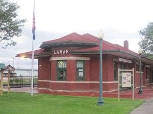
 Main Street facing north in downtown (2007) | |
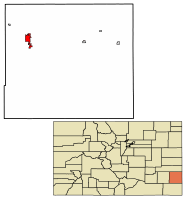 Location of Lamar in Prowers County, Colorado. | |
| Coordinates: 38°05′10″N 102°37′10″W / 38.08611°N 102.61944°WCoordinates: 38°05′10″N 102°37′10″W / 38.08611°N 102.61944°W | |
| Country |
|
| State |
|
| County | Prowers County Seat[1] |
| Incorporated | December 5, 1886[2] |
| Government | |
| • Type | Home Rule Municipality[1] |
| • Mayor | Roger Stagner[3] |
| Area[4] | |
| • Total | 5.20 sq mi (13.47 km2) |
| • Land | 5.18 sq mi (13.41 km2) |
| • Water | 0.02 sq mi (0.05 km2) |
| Elevation[5] | 3,625 ft (1,105 m) |
| Population (2010) | |
| • Total | 7,804 |
| • Estimate (2016)[6] | 7,534 |
| • Density | 1,454.72/sq mi (561.64/km2) |
| Time zone | UTC−7 (Mountain (MST)) |
| • Summer (DST) | UTC−6 (MDT) |
| ZIP code[7] | 81052 |
| Area code(s) | 719 |
| FIPS code | 08-43110 |
| GNIS feature ID | 0203835 |
| Website | City Website |
Lamar is a Home Rule Municipality that is the county seat and the most populous municipality of Prowers County, Colorado, United States.[8] The city population was 7,804 at the 2010 United States Census. The city was named after Lucius Quintus Cincinnatus Lamar II[9] during the period that he was Secretary of the Interior in the futile hope that the then town would be named as the land office.
History
The northern site of the Pierre Auger Observatory of ultra-high energy cosmic rays is planned to be built near Lamar.[10]
Geography and climate
Lamar is located at 38°5′10″N 102°37′10″W / 38.08611°N 102.61944°W. According to the United States Census Bureau, the city has a total area of 4.2 square miles (11 km2), all land. Lamar is east of Pueblo, on the Arkansas River in southeastern Colorado.
Lamar is antipodal, or globally opposite, to Ile Amsterdam, an island in the southern Indian Ocean, making Lamar one of only three locations in the United States that is opposite another landmass on earth.
| Climate data for Lamar, Colorado Averages (1981–2010) Records (2000-2016) | |||||||||||||
|---|---|---|---|---|---|---|---|---|---|---|---|---|---|
| Month | Jan | Feb | Mar | Apr | May | Jun | Jul | Aug | Sep | Oct | Nov | Dec | Year |
| Record high °F (°C) | 74 (23) |
87 (31) |
89 (32) |
94 (34) |
103 (39) |
111 (44) |
109 (43) |
109 (43) |
104 (40) |
95 (35) |
86 (30) |
73 (23) |
111 (44) |
| Average high °F (°C) | 45.1 (7.3) |
49.2 (9.6) |
59.5 (15.3) |
68.8 (20.4) |
77.9 (25.5) |
87.5 (30.8) |
93.0 (33.9) |
90.5 (32.5) |
83.0 (28.3) |
70.3 (21.3) |
56.4 (13.6) |
45.2 (7.3) |
68.9 (20.5) |
| Average low °F (°C) | 14.5 (−9.7) |
18.0 (−7.8) |
26.7 (−2.9) |
36.3 (2.4) |
47.4 (8.6) |
57.5 (14.2) |
62.5 (16.9) |
61.1 (16.2) |
51.2 (10.7) |
36.6 (2.6) |
24.1 (−4.4) |
14.9 (−9.5) |
37.6 (3.1) |
| Record low °F (°C) | −15 (−26) |
−17 (−27) |
−5 (−21) |
14 (−10) |
27 (−3) |
38 (3) |
49 (9) |
49 (9) |
34 (1) |
19 (−7) |
−5 (−21) |
−15 (−26) |
−15 (−26) |
| Average precipitation inches (mm) | 0.44 (11.2) |
0.48 (12.2) |
0.87 (22.1) |
1.32 (33.5) |
2.12 (53.8) |
2.39 (60.7) |
2.36 (59.9) |
2.51 (63.8) |
1.35 (34.3) |
1.01 (25.7) |
0.52 (13.2) |
0.47 (11.9) |
15.84 (402.3) |
| Average snowfall inches (cm) | 6.5 (16.5) |
5.0 (12.7) |
5.0 (12.7) |
1.8 (4.6) |
0.0 (0) |
0.0 (0) |
0.0 (0) |
0.0 (0) |
0.1 (0.3) |
1.4 (3.6) |
3.3 (8.4) |
6.1 (15.5) |
29.2 (74.2) |
| Source: NOAA[11] | |||||||||||||
Demographics
| Historical population | |||
|---|---|---|---|
| Census | Pop. | %± | |
| 1890 | 566 | — | |
| 1900 | 987 | 74.4% | |
| 1910 | 2,977 | 201.6% | |
| 1920 | 2,512 | −15.6% | |
| 1930 | 4,233 | 68.5% | |
| 1940 | 4,445 | 5.0% | |
| 1950 | 6,829 | 53.6% | |
| 1960 | 7,369 | 7.9% | |
| 1970 | 7,797 | 5.8% | |
| 1980 | 7,713 | −1.1% | |
| 1990 | 8,343 | 8.2% | |
| 2000 | 8,869 | 6.3% | |
| 2010 | 7,804 | −12.0% | |
| Est. 2016 | 7,534 | [6] | −3.5% |
| U.S. Decennial Census[12] | |||
As of the census[13] of 2010, there were 7,804 people, 3,102 households, and 1,980 families residing in the city. The population density was 1,858.1 people per square mile (717.4/km²). There were 3,666 housing units at an average density of 872.9/sq mi (337.0/km²). The racial makeup of the city was 78.6% White, 0.7% African American, 1.0% Native American, 0.4% Asian, 0.0% Pacific Islander, 16.3% from other races, and 3.0% from two or more races. Hispanic or Latino of any race were 39.7% of the population.
There were 3,102 households out of which 42.2% were married couples living together, 15.8% had a female householder with no husband present, and 36.2% were non-families. 31.8% of all households were made up of individuals living alone and 12.8% had someone living alone who was 65 years of age or older. The average household size was 2.43 and the average family size was 3.07.
In the city, the population was spread out with 27.8% under the age of 18, 10.4% from 18 to 24, 23.4% from 25 to 44, 24.3% from 45 to 64, and 14.1% who were 65 years of age or older. The median age was 34.1 years. For every 100 females, there were 93.7 males. For every 100 females age 18 and over, there were 88.8 males.
The median income for a household in the city was $31,521, and the median income for a family was $43,588. Males working full-time and year-round had a median income of $31,621 versus $30,148 for females. The per capita income for the city was $16,944. About 21.4% of families and 24.6% of the population were below the poverty line, including 34.1% of those under age 18 and 15.1% of those age 65 or over.
Education
Public schools
Higher education
Lamar is home to Lamar Community College, founded in 1937.[16]
Economy
Originally founded as a town with an agriculture-based economy, in 1982 the German bus manufacturer Neoplan opened a manufacturing plan employing 650, but it closed down in 2006. Ever since, Lamar has relied on tourism.[17]
Infrastructure
Transportation
Rail
Lamar receives intercity passenger rail service via Amtrak's Southwest Chief, which runs between Chicago and Los Angeles, stopping twice each day, once in each direction. See Lamar (Amtrak station).
Highways


Notable people
Notable individuals who were born in or have lived in Lamar include:
- Gordon L. Allott (1907-1989), U.S. Senator from Colorado[18]
- Marvin Ash (1914-1974), jazz pianist[19]
- Doug Brocail (1967- ), baseball pitcher[20]
- Ken Curtis (1916-1991), actor, singer[21]
- Scott Elarton (1976- ), baseball pitcher[22]
- Curt Gentry (1931-2014), journalist, non-fiction author[23]
- Gerald Gregg (1907-1985), illustrator, book cover artist[24]
- Wayne R. Grisham (1923-2011), U.S. Representative from California[25]
- Floyd D. Hall (1916-2012), pilot, airline executive[26]
- Kenneth Kester (1936-2018), Colorado state legislator[27]
- Wesley Tuttle (1917-2003), singer-songwriter, guitarist[28]
- Sandy Vance (1947- ), baseball pitcher[29]
- Sharon Herbaugh (1954 - 1993), a war correspondent for the Associated Press, based in Islamabad, Pakistan. She covered the Afghanistan civil war, and she was the company's first female bureau chief to die while on assignment.[30]
See also
References
- 1 2 "Active Colorado Municipalities". State of Colorado, Department of Local Affairs. Archived from the original on 2010-11-23. Retrieved 2007-09-01.
- ↑ "Colorado Municipal Incorporations". State of Colorado, Department of Personnel & Administration, Colorado State Archives. 2004-12-01. Retrieved 2007-09-02.
- ↑ "2009 - 2011 City Elected Officials". City of Lamar. Retrieved 2011-11-25.
- ↑ "2016 U.S. Gazetteer Files". United States Census Bureau. Retrieved Jul 25, 2017.
- ↑ "US Board on Geographic Names". United States Geological Survey. 2007-10-25. Retrieved 2008-01-31.
- 1 2 "Population and Housing Unit Estimates". Retrieved June 9, 2017.
- ↑ "ZIP Code Lookup". United States Postal Service. Archived from the original (JavaScript/HTML) on November 23, 2010. Retrieved November 13, 2007.
- ↑ "Find a County". National Association of Counties. Retrieved 2011-06-07.
- ↑ Gannett, Henry (1905). The Origin of Certain Place Names in the United States. Government Printing Office. p. 180.
- ↑ Pierre Auger Observatory - Northern Auger Site
- ↑ "Observed Weather Reports". National Oceanic and Atmospheric Administration. Retrieved February 19, 2016.
- ↑ "Census of Population and Housing". Census.gov. Retrieved June 4, 2015.
- ↑ "American FactFinder". United States Census Bureau. Retrieved 2018-02-27.
- ↑ Lamar School District Archived 2011-08-11 at the Wayback Machine.
- ↑ "Lamar School District RE-2". Retrieved 10 January 2014.
- ↑ "About LCC". Retrieved 10 January 2014.
- ↑ "City of Lamar, Colorado Cultural Resource Survey: Architectural & Historical Survey Report" (PDF). historycolorado.com. October 2012. Retrieved 2017-10-03.
- ↑ "Allott, Gordon Llewellyn, (1907-1989)". Biographical Directory of the United States Congress. U.S. Congress. Retrieved 2016-06-21.
- ↑ Edwards, Bill. "Marvin E. Ashbaugh". RagPiano.com. Retrieved 2016-06-21.
- ↑ "Doug Brocail". Baseball-Reference.com. Retrieved 2016-06-21.
- ↑ "Ken Curtis (I)". IMDb. Retrieved 2016-06-21.
- ↑ "Scott Elarton". Baseball-Reference.com. Retrieved 2016-06-21.
- ↑ Nolte, Carl (2014-07-19). "Curt Gentry dies: best-selling writer of Manson, Hoover books". San Francisco Chronicle. Retrieved 2016-06-21.
- ↑ "Summary Bibliography: Gerald Gregg". Internet Speculative Fiction Database. Retrieved 2016-06-21.
- ↑ "Grisham, Wayne Richard, (1923-2011)". Biographical Directory of the United States Congress. U.S. Congress. Retrieved 2016-06-21.
- ↑ Hevesi, Dennis (2012-05-03). "Floyd D. Hall, Head of Eastern Airlines, Dies at 96". The New York Times. Retrieved 2016-06-21.
- ↑ "Kenneth Kester's Biography". Vote Smart. Retrieved 2016-06-21.
- ↑ "Wesley Tuttle [Obituary]". The Independent. 2003-10-15. Archived from the original on July 30, 2011. Retrieved 2016-06-21.
- ↑ "Sandy Vance". Baseball-Reference.com. Retrieved 2016-06-21.
- ↑ {{https://www.independent.co.uk/news/people/obituary-sharon-herbaugh-1456492.html
Further reading
- The National Old Trails Road To Southern California, Part 1 (LA to KC); Automobile Club Of Southern California; 64 pages; 1916. (Download 6.8MB PDF eBook)
- Thomas Lamar Coughlin "Those Southern Lamars" ISBN 0-7388-2410-0
External links
Municipalities and communities of Prowers County, Colorado, United States | ||
|---|---|---|
| City | 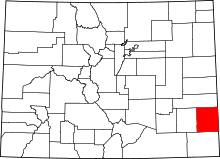 | |
| Towns | ||
| Unincorporated communities | ||