Trinidad, Colorado
| Trinidad, Colorado | |
|---|---|
| Town | |
 Trinidad from Simpsons Rest Overlook | |
 Location of Trinidad in Las Animas County, Colorado. | |
| Coordinates: 37°10′15″N 104°30′23″W / 37.17083°N 104.50639°WCoordinates: 37°10′15″N 104°30′23″W / 37.17083°N 104.50639°W | |
| Country | United States |
| State | Colorado |
| County[1] | Las Animas County – seat[2] |
| Incorporated | December 30, 1879[3] |
| Government | |
| • Type | Home Rule Municipality[1] |
| Area[4] | |
| • Total | 9.28 sq mi (24.02 km2) |
| • Land | 9.28 sq mi (24.02 km2) |
| • Water | 0.00 sq mi (0.00 km2) |
| Elevation[5] | 6,010 ft (1,832 m) |
| Population (2010) | |
| • Total | 9,096 |
| • Estimate (2016)[6] | 8,103 |
| • Density | 873.54/sq mi (337.29/km2) |
| Time zone | UTC−7 (Mountain (MST)) |
| • Summer (DST) | UTC−6 (MDT) |
| ZIP code[7] | 81082 |
| Area code(s) | 719 |
| FIPS code | 08-78610 |
| GNIS feature ID | 0204811 |
| Website | City Website |
Trinidad is a Home Rule Municipality that is the county seat and the most populous city of Las Animas County, Colorado, United States.[8] The population was 9,096 as of the 2010 census, up slightly from 9,078 in 2000. The estimate as of 2012 was 8,771. Trinidad lies 21 mi (34 km) north of Raton, New Mexico, and 195 mi (314 km) south of Denver. Trinidad is situated on the historic Santa Fe Trail.
History
Early
Trinidad was first explored by Spanish and Mexican traders, who liked its proximity to the Santa Fe Trail. It was founded in 1862 soon after coal was discovered in the region. This led to an influx of immigrants, eager to capitalize on this important natural resource. By the late 1860s, the town had about 1,200 residents.[9] Trinidad was officially incorporated in 1876, just a few months before Colorado became a state.[10] An important milestone for the town occurred in 1878, when the Atchison, Topeka and Santa Fe Railway reached Trinidad, making it easier for goods to be shipped from distant locations.[11] In the 1880s, Trinidad became home to a number of well-known people, including Bat Masterson, who briefly served as the town's marshal in 1882.[12] By 1900, the population of Trinidad had grown to 7,500. It was now home to two English-language newspapers, and one that was published in Spanish.[13]
In the early 1900s, Trinidad became nationally known for having the first woman sports editor of a newspaper, Ina Eloise Young.[14] Her expertise was in baseball, and in 1908, she was the only woman sportswriter to cover the World Series.[15] During the same time, Trinidad was also home to a popular semiprofessional baseball team that was briefly coached by Damon Runyon.[16]
Ina Eloise Young is thought to be sitting in the center of the front row, above the white dog, with her mother and father seated on her left. This was a good location to keep a box score and report on the game. Although no byline is used, Ina Eloise Young, as sporting editor, certainly wrote the article that appeared in The Chronicle-News on September 3, 1907, about the three-game series.[17] Damon Runyon is possibly standing on the far left with the other dignitaries in the front-center of the photograph. This event illustrates the popularity of baseball in Colorado at the time and shows Young and Runyon right in the middle of it.
On August 7, 1902, the Bowen Town coal mine, six miles north of Trinidad, experienced a horrific gas explosion, killing 13 miners.[18] At the time, it was one of the worst mining disasters in the state; conditions in the mine provided the impetus for several labor strikes. At one point in late 1903, an estimated 3,000 miners, members of the United Mine Workers of America, went out on strike.[19] In, 1904, Trinidad experienced several disasters. In mid-January, a fire destroyed two blocks of the business section of the town, causing more than $75,000 in damages.[20] Then, in late September, the Trinidad area and the region along the Las Animas River endured an unusually heavy rainstorm, leading to severe flooding; the flood destroyed the Santa Fe railroad station, wiped out every bridge in town, and caused several hundred thousand dollars of property damage.[21] As Trinidad continued to grow, this was also a time when a number of new construction projects began in the downtown area, including a new library, a new city hall, an opera house, and a new hotel.[22]
On April 20, 1914, just 18 mi north of town was the site of the Ludlow Massacre.
Recent
Trinidad was dubbed the "Sex Change Capital of the World",[23] because a local doctor had an international reputation for performing sex reassignment surgery. In the 1960s, Dr. Stanley Biber, a veteran surgeon returning from Korea, decided to move to Trinidad because he had heard that the town needed a surgeon. In 1969, a local social worker asked him if he would perform the surgery for her, which he learned by consulting diagrams and a New York surgeon. Biber attained a reputation as a good surgeon at a time when very few doctors were performing sex-change operations. At his peak, Biber was performing roughly four sex-change operations a day, and the term "taking a trip to Trinidad" became a euphemism for some seeking the procedures he offered. Biber was featured in an episode of South Park, in which elementary school teacher Mr. Garrison undergoes a sex-change operation. Biber's surgical practice was taken over in 2003 by Marci Bowers. Dr. Bowers has since moved the practice to San Mateo, California. The 2008 documentary Trinidad focuses on Marci Bowers and two of her patients.[24]
Drop City, a counterculture artists' community, was formed in 1965 on land about 4 mi (6.4 km) north of Trinidad. Founded by art students and filmmakers from the University of Kansas and University of Colorado at Boulder, Drop City became known as the first rural "hippie commune",[25] and received national attention from Life and Time, as well as from reporters around the world.[26] Drop City was abandoned by the early 1970s, but influenced subsequent alternative-living projects across the country.
In 2017 the town is experiencing a new boom, the city is thriving due to the marijuana industry. CNN asks the question[27] "Did pot money save small town from 'abyss of nothingness'?". Apparently the answer is a resounding "yes" with the town experiencing a new found $4.4 million in tax revenue from $44 million in annual sales of the recreational drug, representing about 5.13% of the states total sales.[28] In 2018 High Times called the town "Weed Town, USA" noting the 23 licensed retail marijuana dispensaries servicing less than 10k people works out to one dispensary per 352 people.[29]
Geography
Trinidad is located at 37°10′15″N 104°30′23″W / 37.17083°N 104.50639°W (37.170944, −104.506447).[30] According to the United States Census Bureau, the city has a total area of 6.3 square miles (16 km2), all of it land.
Trinidad is situated in the Purgatoire River valley in far southern Colorado at an elevation of 6,025 ft (1,836 m). The city lies 13 mi north of the New Mexico border. On the northern end of the town is Simpson's Rest, a prominent bluff named for early resident George Simpson, who is buried atop it. North Avenue leads to a rut-prone county road to the top of Simpson's Rest for overviews of the city. The vista from Simpson's Rest includes Fishers Peak, a prominent mountain of 9,600 ft (2,900 m) in elevation, southeast of the city. To the northwest are the prominent Spanish Peaks.
Climate
Trindad experiences a semiarid climate, with hot summers and cold winters. Summers days are hot, but due to Trinidad's high elevation, summer nights are cool, and temperatures drop sharply after sunset. Winters are cold, but milder than in many mountain towns in Colorado. In the winter, daytime highs are usually above freezing, but temperatures below 0 °F or −17.8 °C are possible, especially at night.
| Climate data for Downtown Trinidad, Colorado | |||||||||||||
|---|---|---|---|---|---|---|---|---|---|---|---|---|---|
| Month | Jan | Feb | Mar | Apr | May | Jun | Jul | Aug | Sep | Oct | Nov | Dec | Year |
| Record high °F (°C) | 78 (26) |
83 (28) |
88 (31) |
89 (32) |
96 (36) |
101 (38) |
101 (38) |
99 (37) |
99 (37) |
90 (32) |
87 (31) |
82 (28) |
101 (38) |
| Average high °F (°C) | 48.5 (9.2) |
51.1 (10.6) |
56.9 (13.8) |
64.9 (18.3) |
73.5 (23.1) |
83.1 (28.4) |
86.8 (30.4) |
84.7 (29.3) |
79.1 (26.2) |
69.3 (20.7) |
56.8 (13.8) |
49.0 (9.4) |
67.0 (19.4) |
| Average low °F (°C) | 18.9 (−7.3) |
21.6 (−5.8) |
27.3 (−2.6) |
34.8 (1.6) |
43.7 (6.5) |
52.5 (11.4) |
57.3 (14.1) |
55.9 (13.3) |
48.8 (9.3) |
37.8 (3.2) |
27.0 (−2.8) |
20.1 (−6.6) |
37.1 (2.8) |
| Record low °F (°C) | −32 (−36) |
−21 (−29) |
−15 (−26) |
−6 (−21) |
22 (−6) |
29 (−2) |
42 (6) |
37 (3) |
23 (−5) |
−3 (−19) |
−15 (−26) |
−26 (−32) |
−32 (−36) |
| Average precipitation inches (mm) | 0.46 (11.7) |
0.64 (16.3) |
1.03 (26.2) |
1.49 (37.8) |
1.88 (47.8) |
1.57 (39.9) |
2.47 (62.7) |
2.29 (58.2) |
1.27 (32.3) |
1.11 (28.2) |
0.75 (19) |
0.60 (15.2) |
15.56 (395.3) |
| Source: The Western Regional Climate Center[31] | |||||||||||||
Demographics
| Historical population | |||
|---|---|---|---|
| Census | Pop. | %± | |
| 1870 | 562 | — | |
| 1880 | 2,226 | 296.1% | |
| 1890 | 5,523 | 148.1% | |
| 1900 | 5,345 | −3.2% | |
| 1910 | 10,204 | 90.9% | |
| 1920 | 10,906 | 6.9% | |
| 1930 | 11,732 | 7.6% | |
| 1940 | 13,223 | 12.7% | |
| 1950 | 12,204 | −7.7% | |
| 1960 | 10,691 | −12.4% | |
| 1970 | 9,901 | −7.4% | |
| 1980 | 9,663 | −2.4% | |
| 1990 | 8,580 | −11.2% | |
| 2000 | 9,078 | 5.8% | |
| 2010 | 9,096 | 0.2% | |
| Est. 2016 | 8,103 | [6] | −10.9% |
| U.S. Decennial Census[32] | |||
As of the census[33] of 2000, 9,078 people, 3,701 households, and 2,335 families resided in the city. The population density was 1,439.4 people per square mile (555.5/km²). The 4,126 housing units averaged 654.2 per square mile (252.5/km²). The racial makeup of the city was 79.97% White, 0.54% African American, 3.02% Native American, 0.43% Asian, 0.14% Pacific Islander, 12.12% from other races, and 3.78% from two or more races. Hispanics or Latinos of any race were 48.07% of the population.
Of the 3,701 households, 29.5% had children under the age of 18 living with them, 43.6% were married couples living together, 14.5% had a female householder with no husband present, and 36.9% were not families; 32.7% of all households were made up of individuals, and 16.2% had someone living alone who was 65 years of age or older. The average household size was 2.36 and the average family size was 2.98.
In the city, the population was distributed as 24.9% under the age of 18, 9.4% from 18 to 24, 24.2% from 25 to 44, 22.6% from 45 to 64, and 18.9% who were 65 years of age or older. The median age was 39 years. For every 100 females, there were 92.5 males. For every 100 females age 18 and over, there were 89.8 males.
The median income for a household in the city was $36,681, and for a family was $33,992. Males had a median income of $27,817 versus $19,064 for females. The per capita income for the city was $17,271. About 16.2% of families and 18.3% of the population were below the poverty line, including 19.6% of those under age 18 and 20.0% of those age 65 or over.
Economy
For many years, Trinidad housed the miners who worked in the coal mines of the Raton Basin south and west of the town. The coal mines are now closed, but since the 1980s, companies have been drilling new gas wells to extract coalbed methane from the remaining coal seams.
Trinidad's location at the foot of Raton Pass, along the Santa Fe Trail between St. Joseph, Missouri, and Santa Fe, New Mexico, has always made it a favored route for travelers, first by foot, then horse and ox-drawn wagon, then by railroad. Today, Interstate 25, the most highly traveled route between Colorado and New Mexico, passes through Trinidad.
The local economy is currently experiencing a boom due to the town's location on the highway and its proximity to the state border. According to a news report, "While the bulk of Colorado's $1.09 billion in 2017 recreational marijuana sales occurred in the state's population hubs of Denver and Arapahoe counties, rural Las Animas County, population 14,083, led the state with more than $3,100 of recreational cannabis sold for every adult and child."[34]
Transportation
Road
Rail
- Trinidad (Amtrak station)
- Stop # 17 along the Southwest Chief
Air
Education
Notable people
- Stanley Biber, physician
- Marci Bowers, physician
- John Elway, Denver Broncos quarterback, executive, pro football Hall of Famer; resident of Cougar Canyon Resort
- John Gagliardi, a native, coached football while attending high school in Trinidad and playing on the squad – NCAA all-time, all-division winningest football coach.
- Erick Hawkins, modern-dance choreographer and dancer, was born in Trinidad.
- Snatam Kaur, singer of Sikh religious music, was born in Trinidad.
- Cissy King, dancer of The Lawrence Welk Show, was born in Trinidad.
- Ronnie Lane, rock musician, lived in Trinidad during final years of his life.
- Bat Masterson, Old West gunman, was town marshal of Trinidad during the 1880s.[35] His brother Jim was also town marshal during the 1880s.
- M. Mike Miller, travel writer and eight-term member of the Alaska House of Representatives, was born in Trinidad.
- Arthur Roy Mitchell, Western artist, was a Trinidad native; the Mitchell Museum houses many of his major works.
- Erskine Sanford, actor, was most notable for his work with Orson Welles in films such as Citizen Kane.
- Bernard J. Sullivan, Roman Catholic bishop, was born in Trinidad in 1889.[36]
- Alice Ivers Tubbs, frontier gambler known as "Poker Alice"[37]
- Thomas Wilson, composer, was born in Trinidad in 1927, lived there 17 months before moving to Glasgow.
- Ed Wolff, actor and circus giant
- Ina Eloise Young, first woman sports editor
Gallery
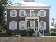 Historic Baca House, the original home of Felipe Baca, the founder of Trinidad
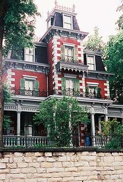 The Bloom Mansion is part of the Trinidad History Museum.
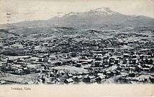 Aerial view of Trinidad circa 1907
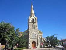 Holy Trinity Catholic Church in downtown Trinidad
 Trinidad City Hall
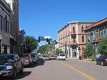 A glimpse of downtown Trinidad with the Columbia Hotel to the rear right
 U.S. Post Office in downtown Trinidad
_IMG_5021.JPG) First fire bell used in Trinidad, 1890-1928
First fire bell used in Trinidad, 1890-1928 Trinidad trolley cars offer free tours of the historic city.
 City of Trinidad locomotive is displayed downtown.
See also
References
- 1 2 "Active Colorado Municipalities". State of Colorado, Department of Local Affairs. Archived from the original on November 23, 2010. Retrieved 2007-09-01.
- ↑ "Colorado County Seats". State of Colorado, Department of Public Health and Environment. Retrieved 2007-12-31.
- ↑ "Colorado Municipal Incorporations". State of Colorado, Department of Personnel & Administration, Colorado State Archives. December 1, 2004. Retrieved 2007-09-02.
- ↑ "2016 U.S. Gazetteer Files". United States Census Bureau. Retrieved July 25, 2017.
- ↑ "US Board on Geographic Names". United States Geological Survey. October 25, 2007. Retrieved 2008-01-31.
- 1 2 "Population and Housing Unit Estimates". Retrieved June 9, 2017.
- ↑ "ZIP Code Lookup". United States Postal Service. Archived from the original (JavaScript/HTML) on November 23, 2010. Retrieved 2008-01-07.
- ↑ "Find a County". National Association of Counties. Retrieved 2011-06-07.
- ↑ "Trinidad, Colorado's History as a stop on the Santa Fe Trail". takearoadtrip.com. Retrieved March 26, 2018.
- ↑ ""Main Street Trinidad." Colorado Magazine Online". coloradomagazineonline.com. Retrieved March 26, 2018.
- ↑ "Trinidad, CO (TRI)". greatamericanstations.com. Retrieved March 26, 2018.
- ↑ "Bartholomew "Bat" Masterson". www.sangres.com. Retrieved March 26, 2018.
- ↑ American Newspaper Directory, 1900 edition, p. 94.
- ↑ "She's Sporting Editor." Editor & Publisher, December 21, 1907, p. 11.
- ↑ C-N Only Coloradio Newspaper That Has Special Writer at World's Championship Games." Trinidad Chronicle-News, October 12, 1908, p. 1.
- ↑ "An All-Star Team Picked by A.D. Runyon." Denver Daily News, September 15, 1907, p. S2.
- ↑ "All Stars Defeated in Three Games by Hard Hitting Trinidads" The Chronicle News, (Trinidad, Colorado), September 3, 1907, p. 1.
- ↑ "Thirteen Miners Blown Up in Mine Near Trinidad." Denver Daily News, August 8, 1902, p. 1.
- ↑ "Almost Unanimous Action By Southern Colorado Men." Denver Daily News, November 9, 1903, p. 2.
- ↑ "Worst Fire in Trinidad's History Destroys Two Business Blocks." Denver Post, January 12, 1904, p. 8.
- ↑ "Destructive Flood Sweeps Trinidad, Colo." Omaha World Herald, October 1, 1904, p. 4.
- ↑ "New Opera House and a City Hall." Denver Daily News, February 20, 1904, p. 11.
- ↑ Calhoun, Patricia (July 29, 2015). "In the Age of Caitlyn Jenner, Trinidad Is No Longer World's Sex-Change Capital". westword.com. Retrieved March 26, 2018.
- ↑ "LAFF '08 INTERVIEW "Trinidad" Co-Directors Jay Hodges and PJ Raval". IndieWire. June 26, 2008. Retrieved September 5, 2015.
- ↑ Rabbit, Peter. (1971). Drop City. The Olympia Press, Inc. p. cover Review
- ↑ "Colorado was ground zero for hippies in '68", Colorado Public Radio, February 12, 2015
- ↑ CNN, Ana Cabrera, Mallory Simon and Sara Weisfeldt, CNN Video by Matthew Gannon and Ken Tillis,. "Can marijuana money save small towns?". CNN. Retrieved 2018-03-04.
- ↑ State of Colorado. "State Retail Marijuana Sales Tax (15%) Tax Revenue from December 2017" (PDF). https://www.colorado.gov/pacific/revenue/colorado-marijuana-tax-data. Retrieved March 3, 2018. External link in
|website=(help) - ↑ "Weed Town, USA: How Marijuana Rescued the Town of Trinidad, Colorado". hightimes.com. Retrieved 2018-07-25.
- ↑ "US Gazetteer files: 2010, 2000, and 1990". United States Census Bureau. February 12, 2011. Retrieved 2011-04-23.
- ↑ "Seasonal Temperature and Precipitation Information". Western Regional Climate Center. Retrieved March 24, 2013.
- ↑ "Census of Population and Housing". Census.gov. Retrieved June 4, 2015.
- ↑ "American FactFinder". United States Census Bureau. Retrieved 2008-01-31.
- ↑ Wallace, Alicia (2018-02-09). "Recreational marijuana sales highest per capita in Colorado's southern border towns". The Cannabist. Retrieved 2018-09-04.
- ↑ Weiser, Kathy (July 2015). "Bat Masterson, Loyalty in Lawlessness". Legends of America.
He also spent a year as marshal of Trinidad, Colorado, as well as serving as Sheriff of South Pueblo, Colorado.
- ↑ "Bishop Bernard James Sullivan, S.J." Catholic-Hierarchy.org. David M. Cheney. Retrieved January 21, 2015.
- ↑ "Kathy Weiser, "Poker Alice – Famous Frontier Gambler"". legendsofamerica.com. Retrieved May 10, 2012.
External links
Municipalities and communities of Las Animas County, Colorado, United States | ||
|---|---|---|
| City | 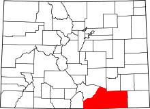 | |
| Towns | ||
| CDPs | ||
| Unincorporated communities | ||
| Ghost towns | ||