| [2] |
Name on the Register |
Image |
Date listed[3] |
Location |
Village |
Description |
|---|
| 1 |
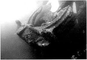
Achugao Bay Site |
|
August 19, 1985
(#75001912) |
Address restricted[4]
|
Umatac |
|
| 2 |
Aga Tongan Archaeological Site |
|
September 26, 2008
(#08000941) |
Address restricted[4]
|
Inarajan |
|
| 3 |
Agaga |
|
June 11, 1975
(#75002155) |
Address restricted[4]
|
Umatac |
|
| 4 |
Agana Historic District |
|
February 8, 1985
(#85000495) |
Roughly bounded by South 2nd, South 3rd, and West 9th, Santa Cruz and Legaspi Streets
13°28′27″N 144°45′52″E / 13.474167°N 144.764306°E / 13.474167; 144.764306 (Agana Historic District) |
Hagåtña |
|
| 5 |
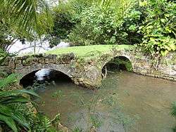
Agana Spanish Bridge |
|
September 6, 1974
(#74002300) |
Aspenall Street and Guam Highway 1
13°28′36″N 144°45′01″E / 13.476667°N 144.750278°E / 13.476667; 144.750278 (Agana Spanish Bridge) |
Hagåtña |
Historic Spanish colonial bridge |
| 6 |
Agana-Hagatna Pillbox |
|
March 4, 1991
(#88001880) |
West shore of Paseo de Susana
13°28′41″N 144°45′58″E / 13.478056°N 144.766111°E / 13.478056; 144.766111 (Agana-Hagatna Pillbox) |
Hagåtña |
|
| 7 |
Agana/Hagatna Cliffline Fortifications |
|
March 4, 1991
(#88001877) |
Address restricted[4]
|
Hagåtña |
|
| 8 |
Agat Invasion Beach |
|
March 4, 1975
(#75001913) |
Coastline northwest of Agat from Toocha Beach south to Bangi
13°23′07″N 144°39′18″E / 13.385278°N 144.655°E / 13.385278; 144.655 (Agat Invasion Beach) |
Agat |
|
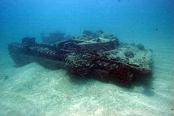
| 9 |
Agat World War II Amtrac |
|
December 13, 2011
(#11000880) |
Address restricted[4]
|
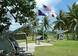
Agat |
Sunken landing vehicle off Agat Beach. |
| 10 |
Aratama Maru |
|
June 2, 1988
(#88000612) |
Talofofo Bay
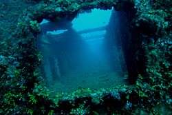
13°20′05″N 144°46′02″E / 13.334861°N 144.767222°E / 13.334861; 144.767222 (Aratama Maru) |
Talofofo |
Japanese freighter that lies at bottom of Talofofo Bay[5] |
| 11 |
As Sombreru Pillbox I |
|
March 4, 1991
(#88001883) |
Address restricted[4]
|
Tamuning |
|
| 12 |
As Sombreru Pillbox II |
|
March 4, 1991
(#88001864) |
South shore of Tumon Beach in Tumon Bay
13°30′19″N 144°47′48″E / 13.505139°N 144.796667°E / 13.505139; 144.796667 (As Sombreru Pillbox II) |
Tamuning |
|
| 13 |
As Sombreru Pillbox III |
|
March 4, 1991
(#88001887) |
West of Matapang Park
13°30′21″N 144°47′47″E / 13.505972°N 144.796389°E / 13.505972; 144.796389 (As Sombreru Pillbox III) |
Tamuning |
|
| 14 |
Asan Invasion Beach |
|
February 14, 1979
(#79002617) |
North edge of Asan
13°28′22″N 144°42′46″E / 13.472778°N 144.712778°E / 13.472778; 144.712778 (Asan Invasion Beach) |
Asan-Maina |
|
| 15 |
Asan Ridge Battle Area |
|
July 18, 1975
(#75001916) |
Between Asan and Nimitz Hill
13°28′06″N 144°42′55″E / 13.468333°N 144.715278°E / 13.468333; 144.715278 (Asan Ridge Battle Area) |
Asan-Maina |
|
| 16 |
Asmaile Point |
|
November 7, 1978
(#78003413) |
Address restricted[4]
|
Merizo |
|
| 17 |
Asquiroga Cave |
|
May 6, 1976
(#76002277) |
Address restricted[4]
|
Talofofo |
|
| 18 |
Atantano Shrine |
|
November 21, 1995
(#95001367) |
300 feet (91 m) southeast of Guam Highway 1 (Marine Drive), north of junction with Guam Highway 2A
13°25′20″N 144°40′34″E / 13.422361°N 144.676111°E / 13.422361; 144.676111 (Atantano Shrine) |
Piti |
|
| 19 |
Ayulang Pillbox |
|
March 4, 1991
(#88001889) |
Address restricted[4]
|
Hagåtña |
|
| 20 |
Baza Outdoor Oven |
|
December 3, 2010
(#10000972) |
West end of Beatrice Baza Rd.[6]
13°24′13″N 144°46′04″E / 13.4036°N 144.7678°E / 13.4036; 144.7678 (Baza Outdoor Oven) |
Yona |
|
| 21 |
Cable Station Ruins |
|
September 6, 1979
(#79003742) |
6 miles (9.7 km) north of Agat
13°26′17″N 144°38′57″E / 13.438056°N 144.649167°E / 13.438056; 144.649167 (Cable Station Ruins) |
Agat |
|
| 22 |
Canada Water Wells |
|
September 26, 2008
(#08000165) |
Near junction of Canada-Toto Road and Canada-Toto Loop Road
13°27′42″N 144°47′04″E / 13.461667°N 144.784444°E / 13.461667; 144.784444 (Canada Water Wells) |
Barrigada |
|
| 23 |
Cetti Bay |
|
November 21, 1974
(#74002036) |
1.1 miles (1.8 km) north-northwest of Umatac
13°18′52″N 144°39′16″E / 13.314444°N 144.654306°E / 13.314444; 144.654306 (Cetti Bay) |
Umatac |
Archaeological site of a village, extending along most of the bay, also known as Jati and as Ati. |
| 24 |
Chaqui'an Massacre Site |
|
April 12, 2016
(#16000129) |
Chalan Emsley
13°34′17″N 144°53′20″E / 13.571291°N 144.888899°E / 13.571291; 144.888899 (Chaqui'an Massacre Site) |
Yigo |
|
| 25 |
Merlyn G. Cook School |
|
November 29, 1979
(#79003743) |
Guam Highway 4
13°16′07″N 144°39′51″E / 13.268684°N 144.664288°E / 13.268684; 144.664288 (Merlyn G. Cook School) |
Merizo |
|
| 26 |
Creto Site |
|
November 7, 1978
(#78003414) |
Address restricted[4]
|
Umatac |
|
| 27 |
Cruz Water Catchment |
|
November 14, 1994
(#94001310) |
53 feet (16 m) south Guam Highway 9, southeast of Pott's Junction
13°35′05″N 144°51′58″E / 13.584861°N 144.866111°E / 13.584861; 144.866111 (Cruz Water Catchment) |
Yigo |
|
| 28 |
Dungcas Beach Defense Guns |
|
December 22, 1976
(#76001965) |
On Agana Bay, off Guam Highway 1
13°29′31″N 144°46′31″E / 13.491806°N 144.775278°E / 13.491806; 144.775278 (Dungcas Beach Defense Guns) |
Tamuning |
|
| 29 |
Fafai Beach Site |
|
November 19, 1974
(#74002316) |
Address restricted[4]
|
Tamuning |
|
| 30 |
Faha Massacre Site |
|
August 27, 1991
(#91001091) |
Off Guam Highway 4, south of Pigua Road
13°16′18″N 144°39′49″E / 13.271667°N 144.663611°E / 13.271667; 144.663611 (Faha Massacre Site) |
Merizo |
|
| 31 |
Fonte River Dam |
|
February 25, 2014
(#14000035) |
Fonte River, immediately southwest of Nimitz Hill Overlook Park
13°27′31″N 144°43′43″E / 13.458630°N 144.728578°E / 13.458630; 144.728578 (Fonte River Dam) |
Asan-Maina |
|
| 32 |
Fort Nuestra Senora de la Soledad |
|
October 18, 1974
(#74002042) |
South of Umatac of Guam Highway 40
13°17′42″N 144°39′36″E / 13.295°N 144.66°E / 13.295; 144.66 (Fort Nuestra Senora de la Soledad) |
Umatac |
|
| 33 |
Fort San Jose |
|
May 1, 1974
(#74002041) |
Northwest of Umatac on Guam Highway 2
13°18′02″N 144°39′31″E / 13.300694°N 144.658611°E / 13.300694; 144.658611 (Fort San Jose) |
Umatac |
|
| 34 |
Fort Santa Agueda |
|
August 30, 1974
(#74002301) |
Guam Highway 7
13°28′25″N 144°44′52″E / 13.473611°N 144.747778°E / 13.473611; 144.747778 (Fort Santa Agueda) |
Hagåtña |
|
| 35 |
Fort Santo Angel |
|
August 10, 1974
(#74002043) |
Northwest corner of Umatac Bay
13°17′56″N 144°39′39″E / 13.298889°N 144.660833°E / 13.298889; 144.660833 (Fort Santo Angel) |
Umatac |
|
| 36 |
Fouha Bay |
|
November 21, 1974
(#74002040) |
Address restricted[4]
|
Umatac |
|
| 37 |
Gadao's Cave |
|
November 19, 1974
(#74002309) |
Address restricted[4]
|
Inarajan |
|
| 38 |
Garapan Mount Pillbox |
|
March 4, 1991
(#88001888) |
Address restricted[4]
|
Talofofo |
|
| 39 |
Gilan |
|
October 26, 2015
(#99001185) |
Address restricted[4]
|
Tamuning |
|
| 40 |
Gongna Beach Gun Emplacement |
|
March 4, 1991
(#88001897) |
East San Vitores Drive
13°31′32″N 144°48′15″E / 13.525578°N 144.804105°E / 13.525578; 144.804105 (Gongna Beach Gun Emplacement) |
Tamuning |
|
| 41 |
Gongna Beach Gun Mount |
|
March 4, 1991
(#88001898) |
East San Vitores Drive
13°31′27″N 144°48′14″E / 13.524167°N 144.803889°E / 13.524167; 144.803889 (Gongna Beach Gun Mount) |
Tamuning |
|
| 42 |
Gonga Beach Mount Pillbox |
|
March 4, 1991
(#88001894) |
East San Vitores Drive
13°31′24″N 144°48′15″E / 13.523333°N 144.804167°E / 13.523333; 144.804167 (Gonga Beach Mount Pillbox) |
Tamuning |
|
| 43 |
Guam Congress Building |
|
February 1, 2007
(#06001320) |
Chalan Santo Papa
13°28′30″N 144°45′08″E / 13.475106°N 144.752358°E / 13.475106; 144.752358 (Guam Congress Building) |
Hagåtña |
|
| 44 |
Guam Institute |
|
October 6, 1977
(#77001568) |
Off Guam Highway 1
13°28′26″N 144°44′44″E / 13.473889°N 144.745556°E / 13.473889; 144.745556 (Guam Institute) |
Hagåtña |
|
| 45 |
Guzman Water Catchment |
|
November 14, 1994
(#94001312) |
0.25 miles (0.40 km) south of Guam Highway 8 and 0.25 miles (0.40 km) east of Guam Highway 10
13°28′02″N 144°48′22″E / 13.467361°N 144.806111°E / 13.467361; 144.806111 (Guzman Water Catchment) |
Barrigada |
|
| 46 |
Ha. 62-76 Japanese midget attack submarine |
|
February 3, 1999
(#99001706) |
Chapel Road near barracks 14, Commander Naval Forces Marianas
13°25′40″N 144°38′46″E / 13.427778°N 144.646111°E / 13.427778; 144.646111 (Ha. 62-76 Japanese midget attack submarine) |
Santa Rita |
|
| 47 |
Hanum Site |
|
November 7, 1978
(#78003416) |
Address restricted[4]
|
Yigo |
|
| 48 |
Haputo Beach Site |
|
November 20, 1974
(#74002308) |
Address restricted[4]
|
Dededo |
|
| 49 |
Hill 40 |
|
March 4, 1975
(#75001910) |
0.2 miles (0.32 km) southwest of Agat off Guam Highway 2
13°22′37″N 144°39′16″E / 13.376944°N 144.654306°E / 13.376944; 144.654306 (Hill 40) |
Agat |
|
| 50 |
Ilik River Fortification I |
|
March 4, 1991
(#88001869) |
Address restricted[4]
|
Yona |
|
| 51 |
Ilik River Fortification II |
|
March 4, 1991
(#88001871) |
Shore of Ylig Point
13°23′11″N 144°46′23″E / 13.386389°N 144.773056°E / 13.386389; 144.773056 (Ilik River Fortification II) |
Yona |
|
| 52 |
Inarajan Pillbox |
|
March 4, 1991
(#88001890) |
Guam Highway 4
13°16′23″N 144°44′53″E / 13.273056°N 144.748194°E / 13.273056; 144.748194 (Inarajan Pillbox) |
Inarajan |
|
| 53 |
Inarajan Ridge |
|
December 4, 1974
(#74002310) |
Address restricted[4]
|
Inarajan |
|
| 54 |
Inarajan Village |
|
November 7, 1977
(#77001569) |
Guam Highway 4
13°16′19″N 144°44′47″E / 13.272083°N 144.746389°E / 13.272083; 144.746389 (Inarajan Village) |
Inarajan |
|
| 55 |
Ipao Pillbox I |
|
March 4, 1991
(#88001863) |
West of Ypao Point
13°30′19″N 144°47′01″E / 13.505278°N 144.783611°E / 13.505278; 144.783611 (Ipao Pillbox I) |
Tamuning |
|
| 56 |
Ipao Pillbox II |
|
March 4, 1991
(#88001873) |
Address restricted[4]
|
Tamuning |
|
| 57 |
Ipao Pillbox III |
|
March 4, 1991
(#88001874) |
Address restricted[4]
|
Tamuning |
|
| 58 |
Jinapsan Site |
|
December 27, 1974
(#74002317) |
Address restricted[4]
|
Yigo |
|
| 59 |
Light Model Tank No. 95 |
|
December 19, 1979
(#79003107) |
Southwest of Yona on Cross Island Road
13°22′47″N 144°45′25″E / 13.379722°N 144.757083°E / 13.379722; 144.757083 (Light Model Tank No. 95) |
Yona |
|
| 60 |
Machagden Point |
|
November 7, 1978
(#78003415) |
Address restricted[4]
|
Umatac |
|
| 61 |
Mahlac Pictograph Cave |
|
November 12, 2014
(#14000891) |
Address restricted[4]
|
Talofofo |
|
| 62 |
Malesso Japanese Rice Mill |
|
November 28, 2012
(#12000973) |
Jesus Barcinas Rd.
13°15′50″N 144°40′16″E / 13.2639°N 144.6712°E / 13.2639; 144.6712 (Malesso Japanese Rice Mill) |
Merizo |
|
| 63 |
Malessu' Pillbox |
|
March 4, 1991
(#88001872) |
Talona Beach on Cocos Lagoon
13°15′39″N 144°40′28″E / 13.260972°N 144.674444°E / 13.260972; 144.674444 (Malessu' Pillbox) |
Merizo |
|
| 64 |
Malolos Site |
|
April 8, 1980
(#80004242) |
Address restricted[4]
|
Inarajan |
|
| 65 |
Mana Pillbox |
|
March 4, 1991
(#88001886) |
South shore of As Anite Cove
13°20′27″N 144°46′12″E / 13.340833°N 144.770000°E / 13.340833; 144.770000 (Mana Pillbox) |
Talofofo |
|
| 66 |
Manenggon Concentration Camp |
|
June 14, 2016
(#16000362) |
Address restricted[4]
|
Yona |
|
| 67 |
Mataguac Hill Command Post |
|
June 10, 1975
(#75002122) |
Off of Guam Highway 1
13°32′36″N 144°52′55″E / 13.543472°N 144.882083°E / 13.543472; 144.882083 (Mataguac Hill Command Post) |
Yigo |
|
| 68 |
Matala' Pillbox |
|
March 4, 1991
(#88001867) |
Address restricted[4]
|
Talofofo |
|
| 69 |
Matgue River Valley Battle Area |
|
April 3, 1975
(#75001917) |
0.6 miles (0.97 km) southwest of Asan of Marine Drive
13°27′54″N 144°42′17″E / 13.465°N 144.704722°E / 13.465; 144.704722 (Matgue River Valley Battle Area) |
Asan-Maina |
|
| 70 |
Memorial Beach Park |
|
August 7, 1974
(#74002039) |
Guam Highway 1
13°28′24″N 144°42′52″E / 13.473333°N 144.714444°E / 13.473333; 144.714444 (Memorial Beach Park) |
Asan-Maina |
|
| 71 |
Merizo Bell Tower |
|
May 29, 1975
(#75002152) |
Guam Highway 4
13°15′57″N 144°40′05″E / 13.265833°N 144.668194°E / 13.265833; 144.668194 (Merizo Bell Tower) |
Merizo |
|
| 72 |
Merizo Conbento |
|
September 17, 1974
(#74002315) |
Guam Highway 4
13°15′57″N 144°40′06″E / 13.265833°N 144.668333°E / 13.265833; 144.668333 (Merizo Conbento) |
Merizo |
|
| 73 |
Mesa House |
|
February 8, 1985
(#85000408) |
Maxwell Street
13°28′09″N 144°45′07″E / 13.469167°N 144.751806°E / 13.469167; 144.751806 (Mesa House) |
Hagåtña |
Historic ifil-constructed house |
| 74 |
Mochom |
|
December 4, 1974
(#74002314) |
Address restricted[4]
|
Mangilao |
|
| 75 |
Mount Tenjo Fortifications |
|
March 13, 1979
(#79003745) |
Northeast of Santa Rita
13°25′10″N 144°41′49″E / 13.419583°N 144.696944°E / 13.419583; 144.696944 (Mount Tenjo Fortifications) |
Santa Rita |
|
| 76 |
Naton Headland Fortification I |
|
March 4, 1991
(#88001884) |
Address restricted[4]
|
Tamuning |
|
| 77 |
Naton Headland Fortification II |
|
March 4, 1991
(#88001885) |
Address restricted[4]
|
Tamuning |
|
| 78 |
Nomna Bay Site |
|
December 27, 1974
(#74002311) |
Address restricted[4]
|
Inarajan |
|
| 79 |
North Inarajan Site |
|
February 21, 1975
(#75002151) |
Address restricted[4]
|
Inarajan |
|
| 80 |
Oka Fortification |
|
March 4, 1991
(#88001882) |
Address restricted[4]
|
Tamuning |
|
| 81 |
Orote Field |
|
June 18, 1975
(#75002149) |
5 miles (8.0 km) north on Orote Peninsula, within Naval Base Guam.
13°26′07″N 144°38′22″E / 13.435278°N 144.639444°E / 13.435278; 144.639444 (Orote Field) |
Santa Rita |
|
| 82 |
Orote Historical Complex |
|
October 23, 1979
(#79003744) |
Naval Station Guam, northern tip of Orote Peninsula[7]
13°26′48″N 144°37′37″E / 13.4466°N 144.6270°E / 13.4466; 144.6270 (Orote Historical Complex) |
Santa Rita |
|
| 83 |
Pagat Site |
|
March 13, 1974
(#74002318) |
Address restricted[4]
|
Yigo |
|
| 84 |
Pagu' Pillbox I |
|
March 4, 1991
(#88001878) |
Shore of Pago Bay
13°25′18″N 144°46′55″E / 13.421667°N 144.782083°E / 13.421667; 144.782083 (Pagu' Pillbox I) |
Chalan Pago-Ordot |
|
| 85 |
Pagu' Pillbox II |
|
March 4, 1991
(#88001879) |
Shore of Pago Bay
13°24′59″N 144°46′56″E / 13.41625°N 144.782361°E / 13.41625; 144.782361 (Pagu' Pillbox II) |
Chalan Pago-Ordot |
|
| 86 |
Paulino Outdoor Oven |
|
December 3, 2010
(#10000971) |
Agfayan Point, south side of Bear Rock Lane[8]
13°15′59″N 144°44′24″E / 13.2664°N 144.74°E / 13.2664; 144.74 (Paulino Outdoor Oven) |
Inarajan |
|
| 87 |
Piti Coastal Defense Guns |
|
June 18, 1975
(#75001909) |
East of junction of Guam Highway 1 and 11
13°27′38″N 144°41′31″E / 13.460556°N 144.692083°E / 13.460556; 144.692083 (Piti Coastal Defense Guns) |
Piti |
|
| 88 |
Plaza de Espana |
|
May 1, 1974
(#74002302) |
Saylor Street
13°28′26″N 144°45′06″E / 13.473889°N 144.751667°E / 13.473889; 144.751667 (Plaza de Espana) |
Hagåtña |
|
| 89 |
Quan Outdoor Oven |
|
December 3, 2010
(#10000970) |
North side, J.C. Santos St. at J.C. Tuncap St.[9]
13°27′50″N 144°41′36″E / 13.4639°N 144.6933°E / 13.4639; 144.6933 (Quan Outdoor Oven) |
Piti |
|
| 90 |
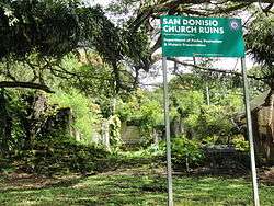
San Dionisio Church Ruins |
|
August 30, 1974
(#74002037) |
Guam Highway 2
13°17′57″N 144°39′47″E / 13.299167°N 144.663056°E / 13.299167; 144.663056 (San Dionisio Church Ruins) |
Umatac |
|
| 91 |
San Vitores Martyrdom Site |
|
October 31, 1975
(#75002154) |
0.7 miles (1.1 km) south of Bijia Point off Guam Highway 4
13°30′59″N 144°48′21″E / 13.516389°N 144.805833°E / 13.516389; 144.805833 (San Vitores Martyrdom Site) |
Tamuning |
|
| 92 |
Francisco Q. Sanchez Elementary School |
|
June 12, 1998
(#98000678) |
Guam Highway 2
13°17′57″N 144°39′49″E / 13.2991°N 144.6635°E / 13.2991; 144.6635 (Francisco Q. Sanchez Elementary School) |
Umatac |
|
| 93 |
Sanvitores Beach Japanese Fortification |
|
March 4, 1991
(#88001891) |
East San Vitores Drive
13°31′00″N 144°48′20″E / 13.516667°N 144.805556°E / 13.516667; 144.805556 (Sanvitores Beach Japanese Fortification) |
Tamuning |
|
| 94 |
Sella Bay Site |
|
November 8, 1974
(#74002038) |
Address restricted[4]
|
Umatac |
|
| 95 |
SMS Cormoran |
|
April 4, 1975
(#75002156) |
Apra Harbor
13°27′45″N 144°39′06″E / 13.4625°N 144.651667°E / 13.4625; 144.651667 (SMS Cormoran) |
Piti |
|
| 96 |
South Finegayan Latte Stone Park |
|
September 5, 1975
(#75002150) |
74 Golden Shower Lane
13°33′08″N 144°49′34″E / 13.552222°N 144.82625°E / 13.552222; 144.82625 (South Finegayan Latte Stone Park) |
Dededo |
|
| 97 |
South Pulantat Site |
|
March 26, 1979
(#79003747) |
Address restricted[4]
|
Yona |
|
| 98 |
South Talofofo Site |
|
February 24, 1975
(#75002153) |
Address restricted[4]
|
Talofofo |
|
| 99 |
Spanish Dikes |
|
November 19, 1974
(#74002303) |
Northeast of Agana Springs
13°27′48″N 144°45′57″E / 13.463333°N 144.765833°E / 13.463333; 144.765833 (Spanish Dikes) |
Hagåtña |
|
| 100 |
Sumay Cemetery |
|
October 8, 1999
(#99001184) |
Marine Drive, Commander Naval Forces Marianas
13°26′09″N 144°39′16″E / 13.435972°N 144.654306°E / 13.435972; 144.654306 (Sumay Cemetery) |
Agat and Santa Rita |
|
| 101 |
Taelayag Spanish Bridge |
|
October 10, 1974
(#74002304) |
West of Guam Highway 2
13°21′16″N 144°38′45″E / 13.354444°N 144.645833°E / 13.354444; 144.645833 (Taelayag Spanish Bridge) |
Agat |
|
| 102 |
Talagi Pictograph Cave |
|
March 24, 2004
(#04001240) |
Andersen Air Force Base
Address Restricted
|
Dededo and Yigo |
|
| 103 |
Taleyfac Spanish Bridge |
|
September 10, 1974
(#74002305) |
Off Guam Highway 2
13°21′48″N 144°38′58″E / 13.363333°N 144.649444°E / 13.363333; 144.649444 (Taleyfac Spanish Bridge) |
Agat |
|
| 104 |
Talisay Site-Latte' Saddok Talisai |
|
November 5, 2014
(#14000892) |
Address restricted[4]
|
Santa Rita |
|
| 105 |
Talofofo River Valley Site |
|
December 27, 1974
(#74002312) |
Address restricted[4]
|
Inarajan |
|
| 106 |
Talofofo-Talu'fofo' Pillbox |
|
March 4, 1991
(#88001876) |
South shore of the Ylig River
13°21′53″N 144°46′02″E / 13.364722°N 144.767361°E / 13.364722; 144.767361 (Talofofo-Talu'fofo' Pillbox) |
Talofofo |
|
| 107 |
Taogam Archeological Settlement |
|
April 15, 1980
(#80004243) |
Address restricted[4]
|
Mangilao |
|
| 108 |
Tinta Massacre Site |
|
November 26, 1991
(#91001720) |
Espinosa Avenue
13°15′49″N 144°40′40″E / 13.263611°N 144.677778°E / 13.263611; 144.677778 (Tinta Massacre Site) |
Merizo |
|
| 109 |
Tokai Maru |
|
July 14, 1988
(#88000967) |
Apra Harbor, Naval Base Guam
13°27′33″N 144°39′15″E / 13.459028°N 144.654167°E / 13.459028; 144.654167 (Tokai Maru) |
Piti |
|
| 110 |
Tokcha' Pillbox |
|
March 4, 1991
(#88001875) |
Toghca Point shoreling, Ipan
13°22′15″N 144°46′09″E / 13.370833°N 144.769167°E / 13.370833; 144.769167 (Tokcha' Pillbox) |
Talofofo |
|
| 111 |
Tomhum Cliffline Fortification I |
|
March 4, 1991
(#88001895) |
East San Vitores Drive
13°30′23″N 144°48′20″E / 13.506389°N 144.805556°E / 13.506389; 144.805556 (Tomhum Cliffline Fortification I) |
Tamuning |
|
| 112 |
Tomhum Cliffline Fortification II |
|
March 4, 1991
(#88001896) |
East San Vitores Drive
13°30′29″N 144°48′23″E / 13.508194°N 144.80625°E / 13.508194; 144.80625 (Tomhum Cliffline Fortification II) |
Tamuning |
|
| 113 |
Tomhum Cliffline Fortification III |
|
March 4, 1991
(#88001868) |
Address restricted[4]
|
Tamuning |
|
| 114 |
Tomhum Pillbox I |
|
March 4, 1991
(#88001893) |
East San Vitores Drive
13°30′47″N 144°48′12″E / 13.513056°N 144.803333°E / 13.513056; 144.803333 (Tomhum Pillbox I) |
Tamuning |
|
| 115 |
Tomhun Pillbox II |
|
March 4, 1991
(#88001866) |
East San Vitores Drive
13°30′33″N 144°48′02″E / 13.509028°N 144.800694°E / 13.509028; 144.800694 (Tomhun Pillbox II) |
Tamuning |
|
| 116 |
Tomhum Pillbox III |
|
March 4, 1991
(#88001865) |
East San Vitores Drive
13°30′23″N 144°47′52″E / 13.50625°N 144.797778°E / 13.50625; 144.797778 (Tomhum Pillbox III) |
Tamuning |
|
| 117 |
Tonhum Fortification I |
|
March 4, 1991
(#88001870) |
Address restricted[4]
|
Tamuning |
|
| 118 |
Torre Water Catchment |
|
November 14, 1994
(#94001311) |
Hatsuho Golf Course
13°34′55″N 144°51′47″E / 13.581944°N 144.863194°E / 13.581944; 144.863194 (Torre Water Catchment) |
Yigo |
|
| 119 |
Toves House |
|
February 8, 1985
(#85000410) |
Marine Drive
13°34′55″N 144°51′38″E / 13.581944°N 144.860417°E / 13.581944; 144.860417 (Toves House) |
Hagåtña |
|
| 120 |
Tumon-Maui Well |
|
March 4, 2016
(#14000893) |
Junction of Marine Corps Drive and Tumon Lane
13°30′35″N 144°48′34″E / 13.509823°N 144.809508°E / 13.509823; 144.809508 (Tumon-Maui Well) |
Dededo |
|
| 121 |
Umang Dam |
|
February 6, 2009
(#08001408) |
South side of Finile Road
13°22′38″N 144°39′27″E / 13.377222°N 144.6575°E / 13.377222; 144.6575 (Umang Dam) |
Agat |
|
| 122 |
Umatac Outdoor Library |
|
November 12, 1999
(#99001301) |
Guam Highway 4
13°17′59″N 144°39′38″E / 13.299722°N 144.660556°E / 13.299722; 144.660556 (Umatac Outdoor Library) |
Umatac |
|
| 123 |
Umatac-Umatak Pillbox |
|
March 4, 1991
(#88001881) |
Address restricted[4]
|
Umatac |
|
| 124 |
U.S. Naval Cemetery |
|
December 1, 2015
(#15000846) |
Marine Corps Drive
13°28′39″N 144°45′28″E / 13.477398°N 144.757768°E / 13.477398; 144.757768 (U.S. Naval Cemetery) |
Hagåtña |
|
| 125 |
Uruno Beach Site |
|
December 27, 1974
(#74002306) |
Address restricted[4]
|
Dededo |
|
| 126 |
Uruno Site |
|
December 27, 1974
(#74002307) |
Address restricted[4]
|
Dededo |
|
| 127 |
War in the Pacific National Historical Park |
|
August 18, 1978
(#78003198) |
Marine Drive
13°23′12″N 144°39′28″E / 13.386667°N 144.657639°E / 13.386667; 144.657639 (War in the Pacific National Historical Park) |
Hagåtña |
|
| 128 |
West Atate |
|
December 4, 1974
(#74002313) |
Address restricted[4]
|
Inarajan |
|
| 129 |
West Bona Site |
|
March 26, 1979
(#79003746) |
Address restricted[4]
|
Santa Rita |
|
| 130 |
Won Pat Outdoor Oven |
|
December 3, 2010
(#10000969) |
Between 114 and 126 Mansanita Ct.[10]
13°27′43″N 144°45′15″E / 13.4619°N 144.7542°E / 13.4619; 144.7542 (Won Pat Outdoor Oven) |
Sinajana |
|
| 131 |
Yokoi's Cave |
|
January 16, 1980
(#80004244) |
Address restricted[4]
|
Talofofo |
|
| 132 |
Ypao Beach Archeological Site |
|
May 24, 1974
(#84000889) |
Address restricted[4]
|
Tamuning |
|
_-_DSC01338.JPG)
_-_DSC00897.JPG)

_-_DSC00864.JPG)
.jpg)
.jpg)