Erie, Colorado
| Town of Erie, Colorado | |
|---|---|
| Statutory Town | |
| Motto(s): Your Future Is Here | |
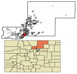 Location of Erie in Boulder County and Weld County, Colorado. | |
| Coordinates: 40°02′25″N 105°02′22″W / 40.040351°N 105.039365°WCoordinates: 40°02′25″N 105°02′22″W / 40.040351°N 105.039365°W[1] | |
| Country |
|
| State |
|
| Counties[2] |
Boulder County Weld County |
| Incorporated | November 15, 1885[3] |
| Government | |
| • Type | Statutory Town[2] |
| Area[4] | |
| • Total | 19.54 sq mi (50.62 km2) |
| • Land | 19.41 sq mi (50.28 km2) |
| • Water | 0.13 sq mi (0.34 km2) |
| Elevation | 5,130 ft (1,564 m) |
| Population (2010) | |
| • Total | 18,135 |
| • Estimate (2016)[5] | 22,803 |
| • Density | 1,174.69/sq mi (453.56/km2) |
| Time zone | UTC−7 (MST) |
| • Summer (DST) | UTC−6 (MDT) |
| ZIP codes[6] | 80154 & 80516 |
| Area code(s) | Both 303 and 720 |
| FIPS code | 08-24950 |
| GNIS feature ID | 0178731 |
| Website |
www |
|
| |
The Town of Erie is a Statutory Town in Boulder and Weld counties in the U.S. state of Colorado. The population as of the 2010 census was 18,135,[7] up from 6,291 at the 2000 census. Erie is located just west of Interstate 25, with easy access to Interstate 70, Denver International Airport and Colorado's entire Front Range. Erie's Planning Area spans 48 square miles (120 km2), extending from the north side of State Highway 52 south to State Highway 7, and between US 287 on the west and Interstate 25 to the east.[8] Erie is approximately 35 minutes from Denver International Airport, 25 minutes from Denver and 20 minutes from Boulder.
The town was named after Erie, Pennsylvania, the former home of an early settler, Richard Van Valkenburg.[9]
Government

The Board of Trustees serves as the legislative and governing body of the town of Erie and is responsible for establishing town policies and goals. The board has the authority to adopt laws, ordinances and resolutions as needed to conduct the business of the town, and by ordinance may enter into contracts or intergovernmental agreements to furnish, receive services or to provide for cooperative service delivery.
Appointed by and serving at the pleasure of the Board of Trustees, the Town Administrator is the chief operating and administrative officer of the town and is responsible for providing professional leadership in the administration and execution of policies and objectives formulated by the board.
Erie Municipal Airport (EIK) is owned and operated by the Town of Erie and is located on Colorado Highway 7, a little over three miles west of Interstate 25. The main runway is concrete paved and 4,700 feet (1,400 m) long.
Geography
Erie is located in the southwest corner of Weld County at 40°2′25″N 105°3′28″W / 40.04028°N 105.05778°W[10] and extends west into eastern Boulder County. It is bordered to the south by the city of Broomfield and to the southwest by the city of Lafayette. Interstate 25 forms part of the eastern border of the town, leading south 22 miles (35 km) to downtown Denver and north 41 miles (66 km) to Fort Collins. Erie is served by Exit 232 off I-25.
According to the United States Census Bureau, Erie has a total area of 17.3 square miles (44.8 km2), of which 17.2 square miles (44.5 km2) is land and 0.12 square miles (0.3 km2), or 0.74%, is water.[7]
Demographics
| Historical population | |||
|---|---|---|---|
| Census | Pop. | %± | |
| 1880 | 358 | — | |
| 1890 | 662 | 84.9% | |
| 1900 | 697 | 5.3% | |
| 1910 | 596 | −14.5% | |
| 1920 | 697 | 16.9% | |
| 1930 | 930 | 33.4% | |
| 1940 | 1,019 | 9.6% | |
| 1950 | 937 | −8.0% | |
| 1960 | 875 | −6.6% | |
| 1970 | 1,090 | 24.6% | |
| 1980 | 1,254 | 15.0% | |
| 1990 | 1,258 | 0.3% | |
| 2000 | 6,291 | 400.1% | |
| 2010 | 18,135 | 188.3% | |
| Est. 2016 | 22,803 | [5] | 25.7% |
| U.S. Decennial Census[11] | |||
As of the 2010 Census, there were 18,135 people in the Town of Erie. According to the 2009 American Community Profile, the racial makeup of the town was 90.6% White, 0.3% African American, 0.1% Native American, 4.1% Asian, 0.00% Pacific Islander, 2.4% from other races, and 2.6% from two or more races. Hispanic or Latino of any race were 9.7% of the population.
According to the Town of Erie Community Development Department, there were 6,485 households. According to the US Census the average household size was 2.91.
Population: Under 5 years - 9.6%, 5 to 9 years - 10.3%, 10 to 14 years - 7.4%, 15 to 19 years - 5.4%, 20 to 24 years - 2.7%, 25 to 29 years - 4.9%, 30 to 34 years - 8.1%, 35 to 39 years - 10.4%, 40 to 44 years - 9.8%, 45 to 49 years - 8.5%, 50 to 54 years - 7.25%, 55 to 59 years - 5.5%, 60 to 64 years - 4.5%, 65 to 69 years - 2.5%, 70 to 74 years - 1.4%, 75 to 79 years - 0.9%, 80 to 84 years - 0.5%, 85 and older - 0.35%.
The median income for a household in the town was $99,804, and the median income for a family was $108,058. The per capita income for the town was $38,965.
Education: Public schools
Erie is divided between two school districts. The majority of the city is within St. Vrain Valley School District, while the southwest portion of the city is in the Boulder Valley School District. St. Vrain Valley School District: Erie Elementary, Erie Middle School, Erie High School, Black Rock Elementary, Red Hawk Elementary, and Aspen Ridge Preparatory School, and soon a new K-8 called Soaring Heights. Boulder Valley School District: Lafayette Elementary, Meadowlark PK-8, Angevine Middle School, and Centaurus High School.
Arts in Erie
There is an active group of artists in Erie; the Arts Coalition of Erie (a 501(c)(3) represents about 70 artists, or approximately 60% of the artists in town. There are good venues for art at the Erie Community Center and High Plains Library, and shows change about every two months.
The Art Center of Erie (known as the A.C.E.) at 625 Pierce Street in Old Town Erie is open for visual and performing arts programs and is operated by the Arts Coalition of Erie. Classes and events are held year round at the site (an old children's library owned by the Town of Erie) leased by the Arts Coalition of Erie.
See also
References
- ↑ "2014 U.S. Gazetteer Files: Places". United States Census Bureau. July 1, 2014. Retrieved January 6, 2015.
- 1 2 "Active Colorado Municipalities". State of Colorado, Department of Local Affairs. Archived from the original on 2010-11-23. Retrieved 2007-09-01.
- ↑ "Colorado Municipal Incorporations". State of Colorado, Department of Personnel & Administration, Colorado State Archives. 2004-12-01. Retrieved 2007-09-02.
- ↑ "2016 U.S. Gazetteer Files". United States Census Bureau. Retrieved Jul 25, 2017.
- 1 2 "Population and Housing Unit Estimates". Retrieved June 9, 2017.
- ↑ "ZIP Code Lookup". United States Postal Service. Archived from the original (JavaScript/HTML) on March 27, 2012. Retrieved September 11, 2007.
- 1 2 "Geographic Identifiers: 2010 Demographic Profile Data (G001): Erie town, Colorado". U.S. Census Bureau, American Factfinder. Retrieved September 26, 2013.
- ↑ "Town of Erie, Colorado: 2005 Comprehensive Plan; Land Use Plan Map". Town of Erie. Retrieved September 26, 2013.
- ↑ Dawson, John Frank. Place names in Colorado: why 700 communities were so named, 150 of Spanish or Indian origin. Denver, CO: The J. Frank Dawson Publishing Co. p. 20.
- ↑ "US Gazetteer files: 2010, 2000, and 1990". United States Census Bureau. 2011-02-12. Retrieved 2011-04-23.
- ↑ "Census of Population and Housing". Census.gov. Archived from the original on May 12, 2015. Retrieved June 4, 2015.
External links
| Wikimedia Commons has media related to Erie, Colorado. |
Municipalities and communities of Boulder County, Colorado, United States | ||
|---|---|---|
| Cities | 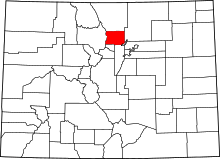 | |
| Towns | ||
| CDPs | ||
| Unincorporated communities | ||
| Ghost town | ||
| Footnotes | ‡This populated place also has portions in an adjacent county or counties | |
Municipalities and communities of Weld County, Colorado, United States | ||
|---|---|---|
| Cities |  | |
| Towns | ||
| CDP | ||
| Unincorporated communities | ||
| Ghost towns | ||
| Footnotes | ‡This populated place also has portions in an adjacent county or counties | |
