Garfield County, Colorado
| Garfield County, Colorado | |
|---|---|
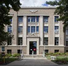 Garfield County Courthouse | |
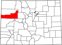 Location in the U.S. state of Colorado | |
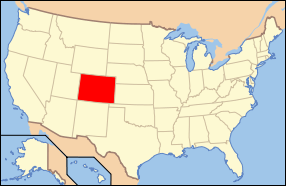 Colorado's location in the U.S. | |
| Founded | February 10, 1883 |
| Named for | James A. Garfield |
| Seat | Glenwood Springs |
| Largest city | Glenwood Springs |
| Area | |
| • Total | 2,956 sq mi (7,656 km2) |
| • Land | 2,948 sq mi (7,635 km2) |
| • Water | 8.3 sq mi (21 km2), 0.3% |
| Population (est.) | |
| • (2015) | 58,095 |
| • Density | 19/sq mi (7/km2) |
| Congressional district | 3rd |
| Time zone | Mountain: UTC−7/−6 |
| Website |
www |
Garfield County is one of the 64 counties in the U.S. state of Colorado. As of the 2010 census, the population was 56,389.[1] The county seat is Glenwood Springs.[2] The county is named in honor of United States President James A. Garfield.[3]
Garfield County is included in the Glenwood Springs, CO Micropolitan Statistical Area, which is also included in the Edwards-Glenwood Springs, CO Combined Statistical Area.
Geography
According to the U.S. Census Bureau, the county has a total area of 2,956 square miles (7,660 km2), of which 2,948 square miles (7,640 km2) is land and 8.3 square miles (21 km2) (0.3%) is water.[4]
Adjacent counties
- Rio Blanco County - north
- Routt County - northeast
- Eagle County - east
- Pitkin County - southeast
- Mesa County - south
- Grand County, Utah - southwest
- Uintah County, Utah - northwest
Protected areas
Scenic byways
- Dinosaur Diamond Prehistoric Highway National Scenic Byway
- Flat Tops Trail Scenic Byway
- West Elk Loop Scenic Byway
Demographics
| Historical population | |||
|---|---|---|---|
| Census | Pop. | %± | |
| 1890 | 4,478 | — | |
| 1900 | 5,835 | 30.3% | |
| 1910 | 10,144 | 73.8% | |
| 1920 | 9,304 | −8.3% | |
| 1930 | 9,975 | 7.2% | |
| 1940 | 10,560 | 5.9% | |
| 1950 | 11,625 | 10.1% | |
| 1960 | 12,017 | 3.4% | |
| 1970 | 14,821 | 23.3% | |
| 1980 | 22,514 | 51.9% | |
| 1990 | 29,974 | 33.1% | |
| 2000 | 43,791 | 46.1% | |
| 2010 | 56,389 | 28.8% | |
| Est. 2016 | 58,887 | [5] | 4.4% |
| U.S. Decennial Census[6] 1790-1960[7] 1900-1990[8] 1990-2000[9] 2010-2015[1] | |||
As of the census[10] of 2000, there were 43,791 people, 16,229 households, and 11,279 families residing in the county. The population density was 15 people per square mile (6/km²). There were 17,336 housing units at an average density of 6 per square mile (2/km²). The racial makeup of the county was 89.96% White, 0.45% Black or African American, 0.71% Native American, 0.44% Asian, 0.08% Pacific Islander, 6.53% from other races, and 1.84% from two or more races. 16.67% of the population were Hispanic or Latino of any race. 18.1% were of German, 11.1% English, 11.0% Irish, 7.1% American and 5.6% Italian ancestry according to Census 2000.
There were 16,229 households out of which 37.20% had children under the age of 18 living with them, 57.60% were married couples living together, 7.80% had a female householder with no husband present, and 30.50% were non-families. 22.80% of all households were made up of individuals and 6.30% had someone living alone who was 65 years of age or older. The average household size was 2.65 and the average family size was 3.11.
In the county, the population was spread out with 27.10% under the age of 18, 9.00% from 18 to 24, 33.00% from 25 to 44, 22.10% from 45 to 64, and 8.80% who were 65 years of age or older. The median age was 34 years. For every 100 females there were 105.60 males. For every 100 females age 18 and over, there were 105.00 males.
The median income for a household in the county was $47,016, and the median income for a family was $53,840. Males had a median income of $37,554 versus $27,280 for females. The per capita income for the county was $21,341. About 4.60% of families and 7.50% of the population were below the poverty line, including 8.10% of those under age 18 and 5.50% of those age 65 or over.
Politics
| Year | Republican | Democratic | Others |
|---|---|---|---|
| 2016 | 49.6% 13,132 | 42.6% 11,271 | 7.8% 2,067 |
| 2012 | 51.4% 12,535 | 46.3% 11,305 | 2.3% 568 |
| 2008 | 49.2% 11,359 | 49.2% 11,357 | 1.6% 366 |
| 2004 | 53.9% 11,123 | 44.7% 9,228 | 1.4% 296 |
| 2000 | 53.2% 9,103 | 35.6% 6,087 | 11.2% 1,914 |
| 1996 | 44.4% 6,281 | 40.5% 5,722 | 15.1% 2,135 |
| 1992 | 31.5% 4,404 | 36.4% 5,082 | 32.1% 4,490 |
| 1988 | 57.2% 6,358 | 41.6% 4,620 | 1.2% 136 |
| 1984 | 69.1% 7,111 | 29.9% 3,076 | 1.0% 98 |
| 1980 | 58.1% 5,416 | 28.3% 2,639 | 13.6% 1,270 |
| 1976 | 59.7% 4,699 | 36.3% 2,852 | 4.0% 315 |
| 1972 | 66.3% 4,452 | 31.1% 2,088 | 2.7% 178 |
| 1968 | 52.2% 3,157 | 37.6% 2,273 | 10.1% 613 |
| 1964 | 41.6% 2,282 | 58.2% 3,196 | 0.2% 10 |
| 1960 | 58.0% 3,215 | 41.8% 2,313 | 0.2% 11 |
| 1956 | 62.9% 3,332 | 36.9% 1,953 | 0.2% 12 |
| 1952 | 68.4% 3,914 | 31.1% 1,777 | 0.5% 28 |
| 1948 | 50.1% 2,416 | 49.0% 2,364 | 0.9% 42 |
| 1944 | 58.0% 2,588 | 41.8% 1,865 | 0.3% 11 |
| 1940 | 57.2% 2,894 | 42.3% 2,141 | 0.5% 26 |
| 1936 | 43.0% 1,945 | 53.1% 2,406 | 3.9% 177 |
| 1932 | 36.1% 1,734 | 61.3% 2,946 | 2.7% 130 |
| 1928 | 60.0% 2,435 | 38.5% 1,562 | 1.5% 59 |
| 1924 | 51.3% 1,934 | 24.3% 917 | 24.4% 921 |
| 1920 | 54.3% 1,912 | 42.3% 1,489 | 3.4% 119 |
| 1916 | 29.9% 1,139 | 65.0% 2,479 | 5.2% 197 |
| 1912 | 21.1% 824 | 46.3% 1,806 | 32.7% 1,275 |
Communities
With 2010 United States Census populations:[12]
Cities
- Glenwood Springs 9,614
- Rifle 9,172
Towns
- Carbondale 6,427
- New Castle 4,518
- Silt 2,930
- Parachute 1,085
Census-designated places
- Battlement Mesa 4,471
- Catherine 228
- Cattle Creek 641
- Chacra 329
- Mulford 174
- No Name 123
See also
References
- 1 2 "State & County QuickFacts". United States Census Bureau. Archived from the original on July 10, 2011. Retrieved June 8, 2014.
- ↑ "Find a County". National Association of Counties. Archived from the original on 2011-05-31. Retrieved 2011-06-07.
- ↑ Gannett, Henry (1905). The Origin of Certain Place Names in the United States. Govt. Print. Off. p. 134.
- ↑ "US Gazetteer files: 2010, 2000, and 1990". United States Census Bureau. 2011-02-12. Retrieved 2011-04-23.
- ↑ "Population and Housing Unit Estimates". Retrieved June 9, 2017.
- ↑ "U.S. Decennial Census". United States Census Bureau. Archived from the original on May 12, 2015. Retrieved June 8, 2014.
- ↑ "Historical Census Browser". University of Virginia Library. Retrieved June 8, 2014.
- ↑ "Population of Counties by Decennial Census: 1900 to 1990". United States Census Bureau. Retrieved June 8, 2014.
- ↑ "Census 2000 PHC-T-4. Ranking Tables for Counties: 1990 and 2000" (PDF). United States Census Bureau. Retrieved June 8, 2014.
- ↑ "American FactFinder". United States Census Bureau. Archived from the original on 2013-09-11. Retrieved 2011-05-14.
- ↑ Leip, David. "Dave Leip's Atlas of U.S. Presidential Elections". uselectionatlas.org. Retrieved May 26, 2017.
- ↑ "Incorporated Places and Minor Civil Divisions: South Dakota". Population Census. 2010 United States Census. 2011-07-18. Retrieved 2012-02-05.
External links
- Garfield County Government website
- Garfield County Statistical Data
- Colorado County Evolution by Don Stanwyck
- Colorado Historical Society
Places adjacent to Garfield County, Colorado | ||||||||||
|---|---|---|---|---|---|---|---|---|---|---|
| ||||||||||
Municipalities and communities of Garfield County, Colorado, United States | ||
|---|---|---|
| Cities | | |
| Towns | ||
| CDPs | ||
| Unincorporated communities | ||
