Delta, Colorado
| Delta, Colorado | |
|---|---|
| Home Rule Municipality | |
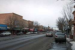 Main Street | |
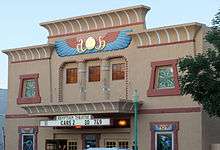
| Nickname(s): City of Murals | |
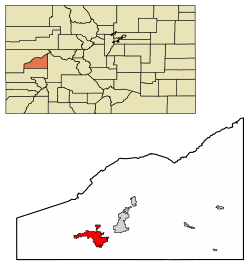 Location of Delta in Delta County, Colorado. | |
| Coordinates: 38°45′27″N 108°05′17″W / 38.757372°N 108.087959°WCoordinates: 38°45′27″N 108°05′17″W / 38.757372°N 108.087959°W[1] | |
| Country |
|
| State |
|
| County | Delta County Seat[2] |
| Incorporated | October 24, 1882[3] |
| Government | |
| • Type | Home Rule Municipality[2] |
| • Mayor | Edward Sisson |
| • Mayor Pro-Tem | Guy Pfalzgraff |
| Area[4] | |
| • Total | 13.63 sq mi (35.30 km2) |
| • Land | 13.35 sq mi (34.57 km2) |
| • Water | 0.28 sq mi (0.73 km2) 2.02% |
| Elevation | 4,953 ft (1,486 m) |
| Population (2010) | |
| • Total | 8,915 |
| • Estimate (2016)[5] | 8,914 |
| • Density | 667.77/sq mi (257.83/km2) |
| Time zone | UTC−7 (MST) |
| • Summer (DST) | UTC−6 (MDT) |
| ZIP code[6] | 81416 |
| Area code(s) | 970 |
| FIPS code | 08-19850 |
| GNIS feature ID | 0185516 |
| Website |
cityofdelta |
The City of Delta is the Home Rule Municipality that is the county seat and the most populous municipality of Delta County, Colorado, United States.[7] The population was 8,915 at the 2010 census,[8] up from 6,400 at the 2000 census. The United States Forest Service headquarters of the Grand Mesa, Gunnison, and Uncompahgre National Forests are located in Delta.
History
Delta was built as a trading post for the Ute people and early settlers. Fort Uncompahgre was built in 1828.[9]
The town was named because of its location on the delta where the Uncompahgre River flows into the Gunnison River.[10] The town was incorporated in 1882.[11]
Geography
Delta is located in southwestern Delta County at 38°44′27″N 108°3′48″W / 38.74083°N 108.06333°W (38.740879, -108.063423).[12] The downtown area is sited south of the Gunnison River and east of the Uncompaghre River. The city limits extend north across the Gunnison into the area now known as "North Delta", then west 6 miles (10 km) along U.S. Route 50 as far as Westwinds Airport.
According to the United States Census Bureau, the city has a total area of 14.0 square miles (36.3 km2), of which 13.7 square miles (35.6 km2) is land and 0.3 square miles (0.7 km2), or 2.02%, is water.[8]
Delta is part of the Colorado Western Slope region.
Tourism
Parks:
- Pow Wow Arbor
- Mountain View Pavilion
- Riley Pavilion / Cleland Park
- Shade Pavilion Island
- Cottonwood Park
- Emerald Hills Park[13]
Demographics
| Historical population | |||
|---|---|---|---|
| Census | Pop. | %± | |
| 1890 | 470 | — | |
| 1900 | 819 | 74.3% | |
| 1910 | 2,388 | 191.6% | |
| 1920 | 2,623 | 9.8% | |
| 1930 | 2,938 | 12.0% | |
| 1940 | 3,717 | 26.5% | |
| 1950 | 4,097 | 10.2% | |
| 1960 | 3,832 | −6.5% | |
| 1970 | 3,694 | −3.6% | |
| 1980 | 3,931 | 6.4% | |
| 1990 | 3,789 | −3.6% | |
| 2000 | 6,400 | 68.9% | |
| 2010 | 8,915 | 39.3% | |
| Est. 2016 | 8,914 | [5] | 0.0% |
| U.S. Decennial Census[14] | |||
As of the census[15] of 2010, there were 8,915 people, 3,530 households, and 2,337 families residing in the city. The population density was 1,682.1 people per square mile (632.3/km²). There were 3,825 housing units at an average density of 721.7 per square mile (271.3/km²). The racial makeup of the city was 82.2% White, 0.2% African American, 1.1% Native American, 0.7% Asian, 12.5% from other races, and 3.1% from two or more races. Hispanic or Latino of any race were 26.1% of the population.
There were 3,530 households out of which 30.3% had children under the age of 18 living with them, 49.3% were married couples living together, 11.6% had a female householder with no husband present, and 33.8% were non-families. 30.0% of all households were made up of individuals and 14.8% had someone living alone who was 65 years of age or older. The average household size was 2.49, and the average family size was 3.08.
In the city, the population was spread out with 26.7% under the age of 18, 8.2% from 18 to 24, 23.2% from 25 to 44, 24.5% from 45 to 64, and 17.5% who were 65 years of age or older. The median age was 38.0 years. For every 100 females, there were 93.8 males. For every 100 females age 18 and over, there were 91.0 males.
Art and culture
Fort Uncompahgre
Fort Uncompahgre was built in 1828, established as a fur trading post by Antoine Robidoux. Tour guides dress in period attire and trap beavers, make buckskins, knap arrowheads, and work the forge.[16]
Media
The principal newspaper is the Delta County Independent, which is published weekly on Wednesdays. Local readers also enjoy The High Country Shopper, a free paper that distributes over 15,000 copies throughout the county.
Infrastructure
Transportation
Montrose Regional Airport, located 21 miles (34 km) south of Delta, is the closest airport served by scheduled airlines. In Grand Junction, which is 39 miles (63 km) to the north, there are also scheduled airline services, as well as an Amtrak train station with a daily California Zephyr departure in each direction.
Major highways


Notable people
- Chuck Cottier, baseball player and manager
- Dale Ishimoto, American actor
- Frank H. Ono, Medal of Honor recipient
See also
References
- ↑ "2014 U.S. Gazetteer Files: Places". United States Census Bureau. July 1, 2014. Retrieved January 5, 2015.
- 1 2 "Active Colorado Municipalities". State of Colorado, Department of Local Affairs. Archived from the original on 2010-11-23. Retrieved 2007-12-01.
- ↑ "Colorado Municipal Incorporations". State of Colorado, Department of Personnel & Administration, Colorado State Archives. 2004-12-01. Retrieved 2007-09-02.
- ↑ "2016 U.S. Gazetteer Files". United States Census Bureau. Retrieved Jul 25, 2017.
- 1 2 "Population and Housing Unit Estimates". Retrieved June 9, 2017.
- ↑ "ZIP Code Lookup". United States Postal Service. Archived from the original (JavaScript/HTML) on November 23, 2010. Retrieved September 6, 2007.
- ↑ "Find a County". National Association of Counties. Archived from the original on 2011-05-31. Retrieved 2011-06-07.
- 1 2 "Geographic Identifiers: 2010 Demographic Profile Data (G001): Delta city, Colorado". U.S. Census Bureau, American Factfinder. Retrieved October 14, 2015.
- ↑ "A History & Heritage Hotbed". Delta County Colorado Tourism. Retrieved 2012-09-07.
- ↑ Dawson, John Frank. Place names in Colorado: why 700 communities were so named, 150 of Spanish or Indian origin. Denver, CO: The J. Frank Dawson Publishing Co. p. 17.
- ↑ "Delta, Colorado". City-Data.com. Retrieved 2012-09-07.
- ↑ "US Gazetteer files: 2010, 2000, and 1990". United States Census Bureau. 2011-02-12. Retrieved 2011-04-23.
- ↑ http://www.delta-co.gov/recreation_aquatics.html
- ↑ "Census of Population and Housing". Census.gov. Archived from the original on May 12, 2015. Retrieved June 4, 2015.
- ↑ "American FactFinder". United States Census Bureau. Archived from the original on 2013-09-11. Retrieved 2008-01-31.
- ↑ "Step back in time…". About Delta Colorado. Retrieved 2012-07-07.
Further reading
- Borowsky, Larry and Cleary, Brooke, "Delta's King of Kings: The Egyptian Theatre and the Bank Night Craze". Colorado Heritage Summer 2002: pp. 2–15
- Ferguson, Olivia Spalding, "A Sketch of Delta County History". The Colorado Magazine 5 (October 1928): pp. 161–164
External links
| Wikivoyage has a travel guide for Delta (Colorado). |
- City of Delta official website
- CDOT map of the City of Delta
- Delta Area Chamber of Commerce
- Delta County Independent
Municipalities and communities of Delta County, Colorado, United States | ||
|---|---|---|
| City | 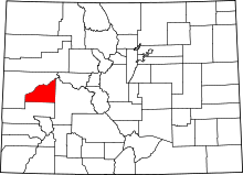 | |
| Towns | ||
| Unincorporated communities | ||
