Sterling, Colorado
| Sterling, Colorado | |
|---|---|
| City | |
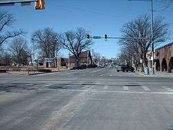 Main Street | |
| Nickname(s): A Colorado Treasure | |
| Motto(s): A Colorado Treasure | |
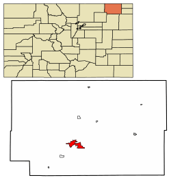 Location of Sterling in Logan County, Colorado. | |
| Coordinates: 40°37′32″N 103°12′42″W / 40.62556°N 103.21167°WCoordinates: 40°37′32″N 103°12′42″W / 40.62556°N 103.21167°W | |
| Country | United States |
| State | Colorado |
| County[1] | Logan County - seat[2] |
| Settled | 1868 |
| Platted | 1890 |
| Incorporated | December 3, 1884[3] |
| Government | |
| • Type | Home Rule Municipality[1] |
| • Mayor | Courtney Pewderschmidt |
| • City Manager | Jackson Conn |
| Area[4] | |
| • Total | 7.62 sq mi (19.72 km2) |
| • Land | 7.62 sq mi (19.72 km2) |
| • Water | 0.00 sq mi (0.00 km2) 0.0% |
| Elevation | 3,937 ft (1,181 m) |
| Population (2010) | |
| • Total | 14,777 |
| • Estimate (2016)[5] | 13,988 |
| • Density | 1,836.90/sq mi (709.26/km2) |
| Time zone | UTC−7 (MST) |
| • Summer (DST) | UTC−6 (MDT) |
| ZIP code[6] | 80751 |
| Area code(s) | 970 |
| FIPS code | 08-73935 |
| GNIS feature ID | 0202901 |
| Website | City of Sterling |
Sterling is a Home Rule Municipality that is the county seat and the most populous city of Logan County, Colorado, United States.[7] The city population was 14,777 at the 2010 census.[8]
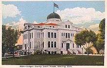
Sterling is the largest city in Northeastern Colorado and the county seat of Logan County and the site of the domed Logan County courthouse, built in 1909.
History
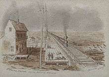
A post office called Sterling has been in operation since 1874.[9] The community was named for Sterling, Illinois, the native home of a railroad official.[10]
Geography
Sterling is 128 miles (206 km) northeast of Denver, and is located on Interstate 76, on the 'eastern plains' of northeastern Colorado.
According to the United States Census Bureau, the city has a total area of 6.9 square miles (18 km2), all land.
Climate
According to the Köppen Climate Classification system, Sterling has a semi-arid climate, abbreviated "BSk" on climate maps.[11]
| Climate data for Sterling, Colorado (1981–2010) | |||||||||||||
|---|---|---|---|---|---|---|---|---|---|---|---|---|---|
| Month | Jan | Feb | Mar | Apr | May | Jun | Jul | Aug | Sep | Oct | Nov | Dec | Year |
| Average high °F (°C) | 42 (6) |
46 (8) |
56 (13) |
64 (18) |
74 (23) |
84 (29) |
91 (33) |
89 (32) |
80 (27) |
67 (19) |
53 (12) |
42 (6) |
66 (19) |
| Average low °F (°C) | 14 (−10) |
18 (−8) |
26 (−3) |
35 (2) |
46 (8) |
56 (13) |
61 (16) |
59 (15) |
48 (9) |
35 (2) |
24 (−4) |
15 (−9) |
36 (3) |
| Average precipitation inches (mm) | 0.30 (7.6) |
0.36 (9.1) |
0.96 (24.4) |
1.33 (33.8) |
2.31 (58.7) |
2.76 (70.1) |
2.66 (67.6) |
1.88 (47.8) |
1.18 (30) |
1.09 (27.7) |
0.54 (13.7) |
0.34 (8.6) |
15.72 (399.3) |
| Average snowfall inches (cm) | 4.0 (10.2) |
4.0 (10.2) |
3.7 (9.4) |
1.8 (4.6) |
0.0 (0) |
0.0 (0) |
0.0 (0) |
0.0 (0) |
0.4 (1) |
1.0 (2.5) |
4.1 (10.4) |
5.8 (14.7) |
24.8 (63) |
| Source: Weather.com[12] | |||||||||||||
Demographics
| Historical population | |||
|---|---|---|---|
| Census | Pop. | %± | |
| 1890 | 540 | — | |
| 1900 | 998 | 84.8% | |
| 1910 | 3,044 | 205.0% | |
| 1920 | 6,415 | 110.7% | |
| 1930 | 7,195 | 12.2% | |
| 1940 | 7,411 | 3.0% | |
| 1950 | 7,534 | 1.7% | |
| 1960 | 10,751 | 42.7% | |
| 1970 | 10,636 | −1.1% | |
| 1980 | 11,385 | 7.0% | |
| 1990 | 10,362 | −9.0% | |
| 2000 | 11,360 | 9.6% | |
| 2010 | 14,777 | 30.1% | |
| Est. 2016 | 13,988 | [5] | −5.3% |
| U.S. Decennial Census[13] | |||


As of the census[14] of 2000, there were 11,360 people, 4,604 households, and 2,790 families residing in the city. The population density was 1,653.1 people per square mile (638.4/km²). There were 5,171 housing units at an average density of 752.5 per square mile (290.6/km²). The racial makeup of the city was 90.75% Caucasian American, 0.75% African American, 0.79% Native American, 0.41% Asian, 0.08% Pacific Islander, 5.60% from other races, and 1.62% from two or more races. Hispanic or Latino of any race were 14.20% of the population.
There were 4,604 households out of which 30.6% had children under the age of 18 living with them, 46.2% were married couples living together, 10.8% had a female householder with no husband present, and 39.4% were non-families. 34.1% of all households were made up of individuals and 14.7% had someone living alone who was 65 years of age or older. The average household size was 2.34 and the average family size was 3.03.
In the city, the population was spread out with 25.5% under the age of 18, 12.9% from 18 to 24, 25.5% from 25 to 44, 19.6% from 45 to 64, and 16.4% who were 65 years of age or older. The median age was 35 years. For every 100 females, there were 94.7 males. For every 100 females age 18 and over, there were 91.2 males.
The median income for a household in the city was $27,337, and the median income for a family was $39,103. Males had a median income of $27,921 versus $20,508 for females. The per capita income for the city was $15,287.
Economy

Major employers in Sterling include Northeastern Junior College, the RE-1 Valley School system, Sykes Enterprises, a computer software customer services company, and the Sterling Correctional Facility.
Sterling is the major shopping hub for most of northeastern Colorado and hosts stores like Wal-Mart, The Home Depot, and J. C. Penney, as well as many local retailers located primarily on Main Street. Six different banks have branches in Sterling and there are local AM and FM radio stations as well as a local television station, and a long established regional newspaper, the Sterling Journal-Advocate and South Platte Sentinel .
Government
The Colorado Department of Corrections operates the Sterling Correctional Facility in Sterling.[15]
Education
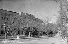
Sterling is the home of Northeastern Junior College, a residential two year college in Colorado.
Sterling is also the location of the RE-1 Valley School District.
Infrastructure
Transportation
Crosson Field Municipal Airport serves Sterling, but there are no scheduled flights available from there. The closest airport served by scheduled flights is Denver International Airport, located 121 miles (195 km) away.
Sterling is also served by railroads, although only freight carriers serve the town. The main rail operator is Burlington Northern Santa Fe (BNSF), but other operators, like Union Pacific, serve Sterling as well. The closest Amtrak station is located in Fort Morgan, about 47 miles (76 km) away.
Scheduled bus service is offered by Black Hills Stage Lines with service to Ft. Morgan and Denver in Colorado, as well as number of cities in Nebraska including North Platte, Kearney, and Omaha.
Highways


Health care
Sterling is a regional center for health care as well, and is the home of the Sterling Regional Medical Center.
See also
References
- 1 2 "Active Colorado Municipalities". State of Colorado, Department of Local Affairs. Archived from the original on 2010-11-23. Retrieved 2007-09-01.
- ↑ "Colorado County Seats". State of Colorado, Department of Public Health and Environment. Retrieved 2007-12-31.
- ↑ "Colorado Municipal Incorporations". State of Colorado, Department of Personnel & Administration, Colorado State Archives. 2004-12-01. Retrieved 2007-09-02.
- ↑ "2016 U.S. Gazetteer Files". United States Census Bureau. Retrieved Jul 25, 2017.
- 1 2 "Population and Housing Unit Estimates". Retrieved June 9, 2017.
- ↑ "ZIP Code Lookup". United States Postal Service. Archived from the original (JavaScript/HTML) on 2010-11-23. Retrieved 2008-01-05.
- ↑ "Find a County". National Association of Counties. Retrieved 2011-06-07.
- ↑ "Annual Estimates of the Population for All Incorporated Places in Colorado". 2005 Population Estimates. U.S. Census Bureau, Population Division. June 21, 2006. Archived from the original (CSV) on July 10, 2009. Retrieved November 17, 2006.
- ↑ "Post offices". Jim Forte Postal History. Retrieved 11 July 2016.
- ↑ Dawson, John Frank. Place names in Colorado: why 700 communities were so named, 150 of Spanish or Indian origin. Denver, CO: The J. Frank Dawson Publishing Co. p. 48.
- ↑ Climate Summary for Sterling, Colorado
- ↑ "Average Weather for Sterling, Colorado - Precipitation and Temperatures". Weather.com. Retrieved October 22, 2014.
- ↑ "Census of Population and Housing". Census.gov. Retrieved June 4, 2015.
- ↑ "American FactFinder". United States Census Bureau. Retrieved 2008-01-31.
- ↑ "SCF - Sterling Correctional Facility." Colorado Department of Corrections. Retrieved on April 19, 2012. "Facility Location: 12101 Hwy 61 Sterling, CO, 80751"
External links
Municipalities and communities of Logan County, Colorado, United States | ||
|---|---|---|
| City | 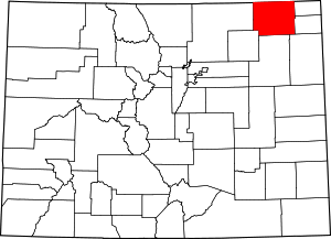 | |
| Towns | ||
| CDPs | ||
| Unincorporated communities | ||
