Dinosaur National Monument
| Dinosaur National Monument | |
|---|---|
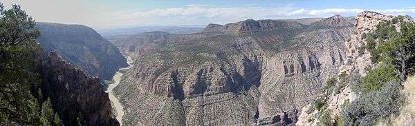
.jpg) Confluence of the Green and Yampa Rivers | |
  | |
| Location | Moffat County, Colorado and Uintah County, Utah, U.S. |
| Nearest city | Vernal, Utah |
| Coordinates | 40°32′N 108°59′W / 40.533°N 108.983°WCoordinates: 40°32′N 108°59′W / 40.533°N 108.983°W |
| Area | 210,844 acres (853.26 km2) |
| Established | October 4, 1915[1] |
| Visitors | 304,312 (in 2016)[2] |
| Governing body | U.S. National Park Service |
| Website |
www |
Dinosaur National Monument is a United States National Monument located on the southeast flank of the Uinta Mountains on the border between Colorado and Utah at the confluence of the Green and Yampa Rivers. Although most of the monument area is in Moffat County, Colorado, the Dinosaur Quarry 40°26′29″N 109°18′04″W / 40.44139°N 109.30111°W is located in Utah just to the north of the town of Jensen, Utah.
The nearest communities are Jensen, Utah, and Dinosaur, Colorado. The park contains over 800 paleontological sites and has fossils of dinosaurs including Allosaurus, Deinonychus, Abydosaurus (a nearly complete skull, lower jaws and first four neck vertebrae of the specimen DINO 16488 found here at the base of the Mussentuchit Member of the Cedar Mountain Formation is the holotype for the description) and various long-neck, long-tail sauropods. It was declared a National Monument on October 4, 1915.[1]
Geology
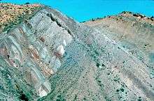
The rock layer enclosing the fossils is a sandstone and conglomerate bed of alluvial or river bed origin known as the Morrison Formation from the Jurassic Period some 150 million years old. The dinosaurs and other ancient animals were carried by the river system which eventually entombed their remains in Utah.
The pile of sediments were later buried and lithified into solid rock. The layers of rock were later uplifted and tilted to their present angle by the mountain building forces that formed the Uintas during the Laramide orogeny. The relentless forces of erosion exposed the layers at the surface to be found by paleontologists.
History
Early scientific explorations
The dinosaur fossil beds (bone beds) were discovered in 1909 by Earl Douglass, a paleontologist working and collecting for the Carnegie Museum of Natural History.[3] He and his crews excavated thousands of fossils and shipped them back to the museum in Pittsburgh, Pennsylvania for study and display. President Woodrow Wilson proclaimed the dinosaur beds as Dinosaur National Monument in 1915. The monument boundaries were expanded in 1938 from the original 80-acre (320,000 m2) tract surrounding the dinosaur quarry in Utah, to its present extent of over 200,000 acres (800 km²) in Utah and Colorado, encompassing the spectacular river canyons of the Green and Yampa.
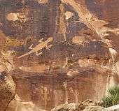
Though lesser-known than the fossil beds, the petroglyphs in Dinosaur National Monument are another treasure the monument holds. Due to problems with vandals, many of the sites are not listed on area maps.
Echo Park Dam Controversy
The plans made by the U.S. Bureau of Reclamation on a ten-dam, billion dollar Colorado River Storage Project began to arouse opposition in the early 1950s when it was announced that one of the proposed dams would be at Echo Park, in the middle of Dinosaur National Monument. The controversy assumed major proportions, dominating conservation politics for years. David Brower, executive director of the Sierra Club, and Howard Zahniser of The Wilderness Society led an unprecedented nationwide campaign to preserve the free-flowing rivers and scenic canyons of the Green and Yampa Rivers. They argued that if a national monument was not safe from development, how could any wildland be kept intact?
On the other side of the argument were powerful members of Congress from western states, who were committed to the project in order to secure water rights, obtain cheap hydroelectric power and develop reservoirs as tourist destinations. After much debate, Congress settled on a compromise that eliminated Echo Park Dam and authorized the rest of the project. The Colorado River Storage Project Act became law on April 11, 1956. It stated, "that no dam or reservoir constructed under the authorization of the Act shall be within any National Park or Monument."
Historians view the Echo Park Dam controversy as signaling the start of an era that includes major conservationist political successes such as the Wilderness Act and the Wild and Scenic Rivers Act.
Historic places
Places on the list of National Register of Historic Places include:[4]
- Prehistoric sites
- Castle Park Archeological District, a prehistoric residential site with inhabition during 1500 - 1000 BC and again from AD 1000 - 1899 by the Prehistoric Fremont culture, Ute and Shoshone people.
- Mantle's Cave is a prehistoric Fremont culture residential site from 499 BC - AD 1749.
- Other sites
Climate
The Dinosaur National Monument sits on a vast area of desert land in Northwestern Colorado and Northeastern Utah. Typical of "high deserts", summer temperatures can be exceedingly hot, while winter temperatures can be very cold. Snowfall is common, but the snow melts rapidly in the arid and sunny climates of these states. Rainfall is very low, and the evaporation rate classifies the area as desert, even though the rainfall exceeds 10 inches.
| Climate data for Dinosaur National Monument | |||||||||||||
|---|---|---|---|---|---|---|---|---|---|---|---|---|---|
| Month | Jan | Feb | Mar | Apr | May | Jun | Jul | Aug | Sep | Oct | Nov | Dec | Year |
| Average high °F (°C) | 33.0 (0.6) |
39.0 (3.9) |
50.4 (10.2) |
60.8 (16) |
71.9 (22.2) |
83.2 (28.4) |
90.5 (32.5) |
87.9 (31.1) |
77.7 (25.4) |
63.6 (17.6) |
45.7 (7.6) |
34.2 (1.2) |
61.5 (16.4) |
| Average low °F (°C) | 10.8 (−11.8) |
15.2 (−9.3) |
25.0 (−3.9) |
31.8 (−0.1) |
40.5 (4.7) |
48.9 (9.4) |
56.6 (13.7) |
54.7 (12.6) |
45.5 (7.5) |
34.9 (1.6) |
23.3 (−4.8) |
12.7 (−10.7) |
33.3 (0.7) |
| Average precipitation inches (mm) | 0.64 (16.3) |
0.56 (14.2) |
0.88 (22.4) |
1.17 (29.7) |
1.30 (33) |
1.06 (26.9) |
1.01 (25.7) |
0.89 (22.6) |
1.24 (31.5) |
1.46 (37.1) |
0.80 (20.3) |
0.62 (15.7) |
11.64 (295.7) |
| Average snowfall inches (cm) | 9.2 (23.4) |
6.6 (16.8) |
5.9 (15) |
3.5 (8.9) |
0.7 (1.8) |
0.2 (0.5) |
0.0 (0) |
0.0 (0) |
0.2 (0.5) |
1.6 (4.1) |
4.7 (11.9) |
8.3 (21.1) |
41.1 (104.4) |
| Source: The Western Regional Climate Center[5] | |||||||||||||
Features


The Quarry
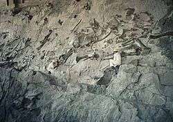
The "Wall of Bones" located within the Dinosaur Quarry building in the park consists of a steeply tilted (67° from horizontal) rock layer which contains hundreds of dinosaur fossils. The enclosing rock has been chipped away to reveal the fossil bones intact for public viewing. In July 2006, the Quarry Visitor Center was closed due to structural problems that since 1957 had plagued the building because it was built on unstable clay. The decision was made to build a new facility elsewhere in the monument to house the visitor center and administrative functions, making it easier to resolve the structural problems of the quarry building while still retaining a portion of the historic Mission 66 era exhibit hall.[6] It was announced in April 2009 that Dinosaur National Monument would receive $13.1 million to refurbish and reopen the gallery as part of the Obama administration's $750 billion stimulus plan.[7] The Park Service successfully rebuilt the Quarry Exhibit Hall, supporting its weight on 70-foot steel micropile columns that extend to the bedrock below the unstable clay.[8] The Dinosaur Quarry was reopened in Fall 2011.
Vertebrate Fossils from Carnegie Quarry
- Now enclosed by the Dinosaur Quarry building (Gilmore (1936), Foster (2003))
- Reptilia
- Testudines
- Amphichelydia
- Glyptops plicatus
- Dinochelys whitei
- Amphichelydia
- Rhynchocephalia
- Opisthias rarus
- Crocodilia
- Mesosuchia
- Gonipholididae
- Goniopholis sp.
- Atoposauridae
- Hoplosuchus kayi (h)
- Gonipholididae
- Mesosuchia
- Dinosauria
- Saurischia
- Theropoda
- Ceratosaurus sp.
- Torvosaurus sp.
- Allosaurus fragilis
- Sauropoda
- Apatosaurus louisae (h)
- Barosaurus lentus
- Camarasaurus lentus
- Diplodocus hallorum
- Uintasaurus douglassi (h) (now Camarasaurus lentus)
- Theropoda
- Ornithischia
- Stegosauria
- Stegosaurus ungulatus
- Ornithopoda
- Iguanodontia
- Uteodon aphanoecetes (h)
- Dryosauridae
- Dryosaurus elderae (h)
- Iguanodontia
- Stegosauria
- (h) = holotype
See also
References
- 1 2 "Dinosaur National Monument Statistics". NPS. January 11, 2008. Retrieved 2009-03-21.
- ↑ "NPS Annual Recreation Visits Report". National Park Service. Retrieved 2017-05-09.
- ↑ Douglass, G.E. (2009). Iverson, Diane Douglass, ed. Speak to the earth and it will teach you : the life and times of Earl Douglass, 1862-1931. Charleston, S.C.: BookSurge. ISBN 9781439244371.
- ↑ National Register of Historic Places in Moffat County American Dreams, Inc. Retrieved 2011-10-6.
- ↑ "Seasonal Temperature and Precipitation Information". Western Regional Climate Center. Retrieved May 3, 2013.
- ↑ "Draft Environmental Impact Statement for Quarry Visitor Center, Part 1" (PDF). National Park Service. March 2007. Archived from the original (PDF) on 2007-06-11. Retrieved 2008-02-11.
- ↑ "$13.1M in stimulus cash revives dino monument". Salt Lake Tribune. April 2009. Archived from the original on 2012-03-22. Retrieved 2009-04-23.
- ↑ "Visiting The Quarry In Fall And Winter". National Park Service. November 2011. Archived from the original on 2011-12-29. Retrieved 2012-03-21.
Further reading
- Cosco, Jon M. (1995). Echo Park : struggle for preservation. Foreward by David R. Brower. Boulder: Johnson Books. ISBN 1-55566-140-8.
- Foster, John R. (2003). "Paleoecological analysis of the vertebrate fauna of the Morrison Formation (Upper Jurassic), Rocky Mountain region, USA". Bulletin of the New Mexico Museum of Natural History. New Mexico Museum of Natural History. 23. Retrieved 3 May 2018.
- Gilmore, Charles W (1936). "Osteology of Apatosaurus, with special references to specimens in the Carnegie Museum". Memoirs of the Carnegie Museum. 11 (4): 177–294.
- Harvey, Mark W. T. (2000). A symbol of wilderness : Echo Park and the American conservation movement. Foreword by William Cronon. Seattle: Univ. of Washington Press. ISBN 0-295-97932-1.
External links
- "Dinosaur National Monument". National Park Service. Retrieved 3 May 2018.
- "Quarry Exhibit Hall". Dinosaur National Monument. National Park Service. Retrieved 3 May 2018.
- Historic American Buildings Survey (HABS) No. surveyUT-138, "Quarry Visitor Center, U.S. Highway 40, 8 miles north of Jensen, Jensen, Uintah County, UT", 42 photos, 86 data pages, 3 photo caption pages
| Topics | |
|---|---|
| Lists by states |
|
| Lists by insular areas | |
| Lists by associated states | |
| Other areas | |
| |