| [1] |
Landmark name |
Image |
Date designated[2] |
Location |
County |
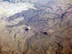
Description |
|---|
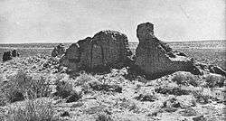
| 1 |
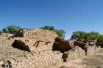
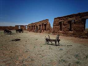
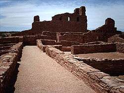
Abo |
|
June 13, 1962
(#66000497) |
Abo
34°26′56″N 106°22′17″W / 34.448889°N 106.371389°W / 34.448889; -106.371389 (Abo) |
Torrance |
Pueblo ruins, and ruins of a Spanish mission, Salinas Pueblo Missions National Monument |
| 2 |
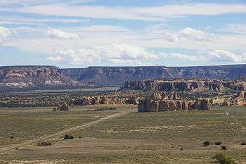
Acoma Pueblo |
|
October 9, 1960
(#66000500) |
Acoma Pueblo
34°53′47″N 107°34′55″W / 34.896389°N 107.581944°W / 34.896389; -107.581944 (Acoma Pueblo) |
Cibola |
Native American pueblo built atop a 225-foot sandstone mesa; one of longest-occupied places in North America |
| 3 |
Bandelier CCC Historic District |
|
May 28, 1987
(#87001452) |
Bandelier National Monument
35°46′46″N 106°16′13″W / 35.77942°N 106.270287°W / 35.77942; -106.270287 (Bandelier CCC Historic District) |
Los Alamos and Sandoval |
Civilian Conservation Corps buildings and infrastructure |
| 4 |
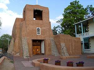
Barrio De Analco Historic District |
|
October 18, 1968
(#68000032) |
Santa Fe
35°41′00″N 105°56′11″W / 35.683333°N 105.936389°W / 35.683333; -105.936389 (Barrio De Analco Historic District) |
Santa Fe |
Historic district including the oldest house in the state of New Mexico, and the oldest Catholic church in the continental United States
(Oldest Churches, Annexed Territories vs original founding Colony States).[3] |
| 5 |
Big Bead Mesa |
|
July 19, 1964
(#66000958) |
Casa Salazar
Address Restricted
|
Sandoval |
Fortified Navajo village site; served as a base for trade and raiding from 1745 to 1812 |
| 6 |
Blackwater Draw |
|
January 20, 1961
(#66000483) |
Clovis
34°16′40″N 103°19′28″W / 34.277874°N 103.32458°W / 34.277874; -103.32458 (Blackwater Draw) |
Roosevelt |
Archaeological type site of the Clovis culture |
| 7 |
Ernest L. Blumenschein House |
|
December 21, 1965
(#66000495) |
Taos
36°24′21″N 105°34′37″W / 36.405954°N 105.576890°W / 36.405954; -105.576890 (Ernest L. Blumenschein House) |
Taos |
Home of painter Ernest L. Blumenschein, co-founder of Taos Art Colony |
| 8 |
Carlsbad Irrigation District |
|
July 19, 1964
(#66000476) |
Carlsbad
32°29′27″N 104°15′08″W / 32.490796°N 104.252119°W / 32.490796; -104.252119 (Carlsbad Irrigation District) |
Eddy |
Early 20th-century water reclamation project |
| 9 |
Kit Carson House |
|
May 23, 1963
(#66000948) |
Taos
36°24′19″N 105°34′20″W / 36.405159°N 105.572131°W / 36.405159; -105.572131 (Kit Carson House) |
Taos |
Home of frontiersman Kit Carson |
| 10 |
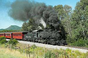
Denver & Rio Grande Railroad San Juan Extension (Cumbres & Toltec Scenic Railroad) |
|
October 16, 2012
(#73000462) |
Antonito, CO and Chama, NM
36°59′04″N 106°18′20″W / 36.98442°N 106.305563°W / 36.98442; -106.305563 (Denver & Rio Grande Railroad San Juan Extension) |
Archuleta, CO, Conejos, CO, and Rio Arriba, NM |
Longest and most complete representation of late nineteenth- and early twentieth-century railroading. |
| 11 |
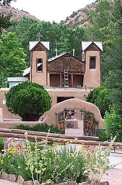
El Santuario De Chimayo |
|
April 15, 1970
(#70000412) |
Chimayo
35°59′21″N 105°55′54″W / 35.989167°N 105.931667°W / 35.989167; -105.931667 (El Santuario De Chimayo) |
Santa Fe |
Roman Catholic church, famous for the story of its founding and as a contemporary pilgrimage site |
| 12 |
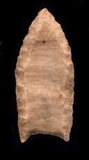
Folsom Site |
|
January 20, 1961
(#66000473) |
Folsom
36°52′54″N 104°04′16″W / 36.88169°N 104.07108°W / 36.88169; -104.07108 (Folsom Site) |
Colfax |
Archaeological site; type site for the Folsom tradition |
| 13 |
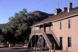
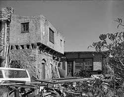
Fort Bayard Site |
|
March 19, 2004
(#02000726) |
Santa Clara
32°47′47″N 108°08′56″W / 32.796389°N 108.148889°W / 32.796389; -108.148889 (Fort Bayard Site) |
Grant |
Site of an 1866 post of Buffalo Soldiers |
| 14 |
Glorieta Pass Battlefield |
|
November 5, 1961
(#66000486) |
Pecos
35°33′36″N 105°47′08″W / 35.56°N 105.785556°W / 35.56; -105.785556 (Glorieta Pass Battlefield) |
Santa Fe |
Site of American Civil War Battle of Glorieta Pass |
| 15 |
Hawikuh |
|
October 9, 1960
(#66000502) |
Zuni
34°56′18″N 108°59′57″W / 34.938404°N 108.999155°W / 34.938404; -108.999155 (Hawikuh) |
Cibola |
Largest of the Zuni pueblos; founded in the 13th century |
| 16 |
Las Trampas Historic District |
|
May 28, 1967
(#67000007) |
Las Trampas
36°07′51″N 105°45′48″W / 36.130701°N 105.763285°W / 36.130701; -105.763285 (Las Trampas Historic District) |
Taos |
Founded in 1751 by twelve Spanish families from Santa Fe; known for the church of San José de Gracia |
| 17 |
Lincoln Historic District |
|
December 19, 1960
(#66000477) |
Lincoln
33°29′41″N 105°22′56″W / 33.494722°N 105.382222°W / 33.494722; -105.382222 (Lincoln Historic District) |
Lincoln |
Well-preserved cow town |
| 18 |
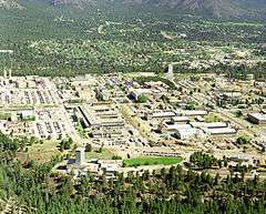
Los Alamos Scientific Laboratory |
|
December 21, 1965
(#66000893) |
Los Alamos
35°52′32″N 106°19′27″W / 35.875556°N 106.324167°W / 35.875556; -106.324167 (Los Alamos Scientific Laboratory) |
Los Alamos |
United States Department of Energy (DOE) national laboratory; major site of the Manhattan Project |
| 19 |
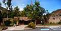
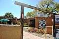
Mabel Dodge Luhan House |
|
December 4, 1991
(#78001832) |
Taos
36°24′29″N 105°33′52″W / 36.408056°N 105.564444°W / 36.408056; -105.564444 (Mabel Dodge Luhan House) |
Taos |
Artists' haven of Mabel Dodge Luhan, now an inn |
| 20 |
Manuelito Complex |
|
July 19, 1964
(#66000894) |
Manuelito
Address Restricted
|
McKinley |
Major post-Chaco culture sites |
| 21 |
Mesilla Plaza |
|
July 4, 1961
(#82003323) |
Mesilla
32°16′28″N 106°47′44″W / 32.274311°N 106.795462°W / 32.274311; -106.795462 (Mesilla Plaza) |
Doña Ana |
Town center historically associated with US acquisition of New Mexico |
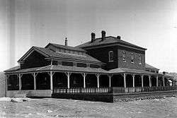
| 22 |
National Park Service Region III Office |
|
May 28, 1987
(#70000067) |
Santa Fe
35°39′54″N 105°55′21″W / 35.665134°N 105.922622°W / 35.665134; -105.922622 (National Park Service Region III Office) |
Santa Fe |
Masterpiece of Spanish/Pueblo revival architecture |
| 23 |
Georgia O'Keeffe Home and Studio |
|
August 5, 1998
(#98001197) |
Abiquiu
36°12′22″N 106°19′01″W / 36.206172°N 106.316872°W / 36.206172; -106.316872 (Georgia O'Keeffe Home and Studio) |
Rio Arriba |
Home and studio of artist Georgia O'Keeffe |
| 24 |
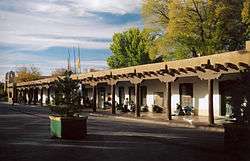
Palace of the Governors |
|
October 9, 1960
(#66000489) |
Santa Fe
35°41′09″N 105°56′15″W / 35.685936°N 105.937504°W / 35.685936; -105.937504 (Palace of the Governors) |
Santa Fe |
Adobe structure; construction began in 1610; served as the seat of government in New Mexico for centuries; oldest continuously occupied public building in the United States |
| 25 |
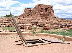
Pecos Pueblo |
|
October 9, 1960
(#66000485) |
Pecos
35°33′00″N 105°41′22″W / 35.549905°N 105.68939°W / 35.549905; -105.68939 (Pecos Pueblo) |
San Miguel |
Large pueblo abandoned in 19th century; in Pecos National Historical Park |
| 26 |
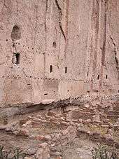
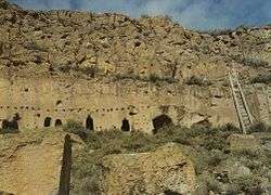
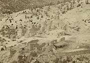
Puye Ruins |
|
May 23, 1966
(#66000481) |
Espanola
35°58′32″N 106°13′39″W / 35.975556°N 106.2275°W / 35.975556; -106.2275 (Puye Ruins) |
Rio Arriba and Sandoval |
Ancestral Puebloan cliff dwellings |
| 27 |
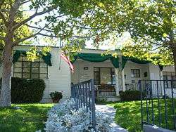
Ernie Pyle House |
|
September 20, 2006
(#97001103) |
Albuquerque
35°04′13″N 106°36′45″W / 35.070156°N 106.612581°W / 35.070156; -106.612581 (Ernie Pyle House) |
Bernalillo |
Former home of famed war correspondent Ernie Pyle |
| 28 |
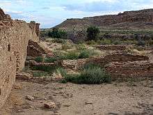
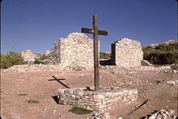
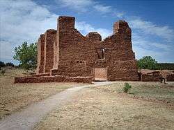
Quarai |
|
June 13, 1962
(#66000498) |
Manzano
34°35′45″N 106°17′42″W / 34.595833°N 106.295°W / 34.595833; -106.295 (Quarai) |
Torrance |
Pueblo and Spanish mission ruins; part of Salinas Pueblo Missions National Monument |
| 29 |
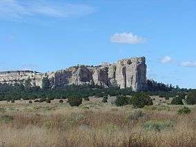
Rabbit Ears |
|
May 23, 1963
(#66000499) |
Clayton
36°35′32″N 103°13′28″W / 36.592222°N 103.224444°W / 36.592222; -103.224444 (Rabbit Ears) |
Union |
Twin mountain peaks that were landmarks to wagon trains on Santa Fe Trail |
| 30 |
Raton Pass |
|
December 19, 1960
(#66000474) |
Raton, NM and Trinidad, CO
36°59′28″N 104°29′12″W / 36.991134°N 104.486654°W / 36.991134; -104.486654 (Raton Pass) |
Colfax |
Mountain pass on the Santa Fe Trail along the Colorado-New Mexico border. Extends into Las Animas County, Colorado. |
| 31 |
San Estevan Del Rey Mission Church |
|
April 15, 1970
(#70000417) |
Acoma
34°53′42″N 107°34′57″W / 34.895068°N 107.582476°W / 34.895068; -107.582476 (San Estevan Del Rey Mission Church) |
Cibola |
Church founded in 1629 |
| 32 |
San Francisco de Assisi Mission Church |
|
April 15, 1970
(#70000416) |
Ranchos de Taos
36°21′31″N 105°36′28″W / 36.3586°N 105.6078°W / 36.3586; -105.6078 (San Francisco de Assisi Mission Church) |
Taos |
Mission church on Ranchos de Taos Plaza |
| 33 |
San Gabriel De Yungue-ouinge |
|
July 19, 1964
(#66000482) |
Ohkay Owingeh
36°03′26″N 106°05′01″W / 36.057306°N 106.083593°W / 36.057306; -106.083593 (San Gabriel De Yungue-ouinge) |
Rio Arriba |
Site of the first Spanish capital of New Mexico |
| 34 |
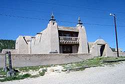
San José de Gracia Church |
|
April 15, 1970
(#70000415) |
Las Trampas
36°07′53″N 105°45′28″W / 36.131389°N 105.757778°W / 36.131389; -105.757778 (San José de Gracia Church) |
Taos |
Built between 1760 and 1776; model of the adobe architecture; once used by Los Hermanos Penitentes |
| 35 |
San Jose de los Jemez Mission and Giusewa Pueblo Site |
|
October 16, 2012
(#73001147) |
Jemez Springs
35°46′42″N 106°41′11″W / 35.778445°N 106.686498°W / 35.778445; -106.686498 (San Jose de los Jemez Mission and Giusewa Pueblo Site) |
Sandoval |
|
| 36 |
San Lazaro |
|
July 19, 1964
(#66000490) |
Santa Fe
Address Restricted
|
Santa Fe |
|
| 37 |
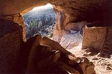
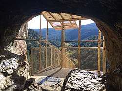
Sandia Cave |
|
January 20, 1961
(#66000487) |
Bernalillo
35°15′08″N 106°24′27″W / 35.252221°N 106.407583°W / 35.252221; -106.407583 (Sandia Cave) |
Sandoval |
Cave in which prehistoric artifacts were found and excavated in the 1930s. Accessible via a USFS hiking trail. |
| 38 |
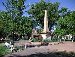
Santa Fe Plaza |
|
December 19, 1960
(#66000491) |
Santa Fe
35°41′07″N 105°56′15″W / 35.685396°N 105.937498°W / 35.685396; -105.937498 (Santa Fe Plaza) |
Santa Fe |
Central park lined with grass, trees, and benches; Indian War Memorial monument; performing arts stage |
| 39 |
Seton Village |
|
December 21, 1965
(#66000492) |
Santa Fe
35°35′56″N 105°55′54″W / 35.598889°N 105.931667°W / 35.598889; -105.931667 (Seton Village) |
Santa Fe |
|
| 40 |
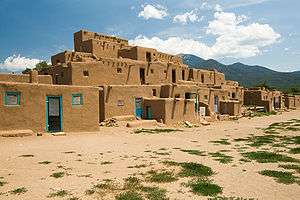
Taos Pueblo |
|
October 9, 1960
(#66000496) |
Taos
36°26′21″N 105°32′44″W / 36.43917°N 105.54559°W / 36.43917; -105.54559 (Taos Pueblo) |
Taos |
This ancient pueblo belongs to a Northern Tiwa speaking Native American tribe of Pueblo people. Being approximately 1000 years old, it is believed to be the oldest continuously inhabited building in North America. It is a multi-storied residential complex of reddish-brown adobe divided into two parts by the Rio Pueblo de Taos. |
| 41 |
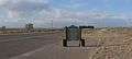
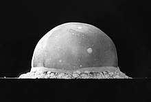
Trinity Site |
|
December 21, 1965
(#66000493) |
Bingham
33°40′38″N 106°28′31″W / 33.6773°N 106.4754°W / 33.6773; -106.4754 (Trinity Site) |
Socorro |
Site of the first nuclear weapon detonation. |
| 42 |
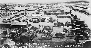
Village of Columbus and Camp Furlong |
|
May 15, 1975
(#75001164) |
Columbus
31°49′39″N 107°37′50″W / 31.8275°N 107.630556°W / 31.8275; -107.630556 (Village of Columbus and Camp Furlong) |
Luna |
Site of 1914 raid by Pancho Villa that had wide impacts |
| 43 |
Wagon Mound |
|
May 23, 1963
(#66000478) |
Wagon Mound
36°00′01″N 104°41′41″W / 36.000278°N 104.694722°W / 36.000278; -104.694722 (Wagon Mound) |
Mora |
Landmark on the Santa Fe Trail |
| 44 |
Watrous (La Junta) |
|
May 23, 1963
(#66000480) |
Watrous
35°48′03″N 105°00′05″W / 35.800833°N 105.001389°W / 35.800833; -105.001389 (Watrous (La Junta)) |
Mora |
Mountain and Cimarron Cutoff routes of Santa Fe Trail joined here |
| 45 |
White Sands V-2 Launching Site |
|
October 3, 1985
(#85003541) |
White Sands Missile Range
32°23′58″N 106°22′40″W / 32.399378°N 106.377814°W / 32.399378; -106.377814 (White Sands V-2 Launching Site) |
Doña Ana |
|
| 46 |
Zuni-Cibola Complex |
|
December 2, 1974
(#74002267) |
Zuni Pueblo
34°56′17″N 108°59′56″W / 34.938°N 108.999°W / 34.938; -108.999 (Zuni-Cibola Complex) |
Cibola and McKinley |
Complex of prehistoric and historic archaeological sites on Zuni Reservation |
.jpg)
.jpg)
.jpg)
.jpg)
.jpg)
.jpg)
.jpg)