National Register of Historic Places listings in New Mexico

This is a list of properties and districts in New Mexico that are on the National Register of Historic Places. There are more than 1,100 listings. Of these, 46 are National Historic Landmarks. There are listings in each of the state's 33 counties.
The tables linked below are intended to provide a complete list of properties and districts listed in each county. The locations of National Register properties and districts with latitude and longitude data may be seen in an online map by clicking on "Map of all coordinates".[1]
The names on the lists are as they were entered into the National Register; some place names are uncommon or have changed since being added to the National Register.
- This National Park Service list is complete through NPS recent listings posted October 11, 2018.[2]
Current listings by county
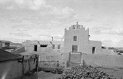 Laguna Pueblo Valencia County 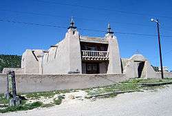 Las Trampas Historic District Taos County |
|
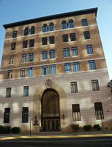 Federal Building and U.S. Courthouse (Albuquerque) Bernalillo County | ||||||||||||||||||||||||||||||||||||||||||||||||||||||||||||||||||||||||||||||||||||||||||||||||||||||||||||||||||||||||||||||||||||||||||||||||
See also
| Wikimedia Commons has media related to National Register of Historic Places in New Mexico. |
References
- ↑ The latitude and longitude information provided in this table was derived originally from the National Register Information System, which has been found to be fairly accurate for about 99% of listings. For about 1% of NRIS original coordinates, experience has shown that one or both coordinates are typos or otherwise extremely far off; some corrections may have been made. A more subtle problem causes many locations to be off by up to 150 yards, depending on location in the country: most NRIS coordinates were derived from tracing out latitude and longitudes from USGS topographical quadrant maps created under the North American Datum of 1927, which differs from the current, highly accurate WGS84 GPS system used by most on-line maps. Chicago is about right, but NRIS longitudes in Washington are higher by about 4.5 seconds, and are lower by about 2.0 seconds in Maine. Latitudes differ by about 1.0 second in Florida. Some locations in this table may have been corrected to current GPS standards.
- ↑ "National Register of Historic Places: Weekly List Actions". National Park Service, United States Department of the Interior. Retrieved on October 11, 2018.
- ↑ Bandelier CCC Historic District in Los Alamos and Sandoval counties; Bandelier National Monument in Los Alamos, Sandoval, and Santa Fe Counties; Crow Canyon Archaeological District in San Juan and Rio Arriba Counties; Gran Quivera Historic District in Socorro and Torrance counties; Puye Ruins in Rio Arriba and Sandoval counties; Route 66, State maintained from Montoya to Cuervo in Guadalupe and Quay counties; Posi-ouinge in Rio Arriba and Taos counties; Salinas Pueblo Missions National Monument in Socorro and Torrance counties; and Zuni-Cibola Complex in Cibola and McKinley counties
- ↑ Bandelier CCC Historic District in Los Alamos and Sandoval counties; Puye Ruins in Rio Arriba and Sandoval counties; and Zuni-Cibola Complex in Cibola and McKinley counties
| Topics | |
|---|---|
| Lists by states |
|
| Lists by insular areas | |
| Lists by associated states | |
| Other areas | |
| |
Santa Fe (capital) | ||
| Topics |
| |
| Society | ||
| Regions |
| |
| Cities | ||
| Counties | ||

This article is issued from
Wikipedia.
The text is licensed under Creative Commons - Attribution - Sharealike.
Additional terms may apply for the media files.