Tunnsjøen
| Tunnsjøen Dåtnejaevrie | |
|---|---|
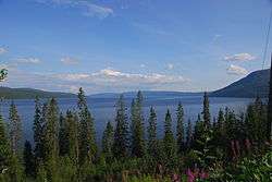 Tunnsjøen as seen from the north-west shore. Gudfjelløya to the right. | |
 Tunnsjøen Location of the lake  Tunnsjøen Tunnsjøen (Norway) | |
| Location | Lierne and Røyrvik, Trøndelag |
| Coordinates | 64°42′18″N 13°12′42″E / 64.7050°N 13.2116°ECoordinates: 64°42′18″N 13°12′42″E / 64.7050°N 13.2116°E |
| Basin countries | Norway |
| Max. length | 20 kilometres (12 mi) |
| Max. width | 10 kilometres (6.2 mi) |
| Surface area | 100.18 km2 (38.68 sq mi) |
| Max. depth | 220 metres (720 ft) |
| Water volume | 8.68 cubic kilometres (2.08 cu mi) |
| Shore length1 | 118 kilometres (73 mi) |
| Surface elevation | 358 metres (1,175 ft) |
| Islands | Gudfjelløya |
| References | NVE |
| 1 Shore length is not a well-defined measure. | |
Tunnsjøen (Southern Sami: Dåtnejaevrie) is a lake in the municipalities of Røyrvik and Lierne in Trøndelag county, Norway. The 100.18-square-kilometre (38.68 sq mi) lake lies just south of the large lake Limingen, and just west of the border with Sweden. It is 358 metres (1,175 ft) above sea level and has a volume of 8.68 cubic kilometres (2.08 cu mi). The deepest part of the lake is 220 metres (720 ft) deep. It is the seventh largest lake in Norway.[1]
Gudfjelløya
The island Gudfjelløya (Southern Sami: Tjåehkere) lies in Tunnsjøen lake. It has a high point of 812 metres (2,664 ft) above sea level, which is 454 metres (1,490 ft) higher than the lake. This makes Gudfjelløya the highest island on a lake in Norway.
References
- ↑ Store norske leksikon. "Tunnsjøen" (in Norwegian). Retrieved 2011-09-07.
This article is issued from
Wikipedia.
The text is licensed under Creative Commons - Attribution - Sharealike.
Additional terms may apply for the media files.