Little Compton, Rhode Island
| Little Compton, Rhode Island | |
|---|---|
| Town | |
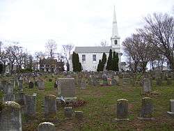 Town Common | |
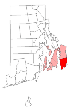 Location of Little Compton in Newport County, Rhode Island | |
| Coordinates: 41°30′N 71°10′W / 41.500°N 71.167°WCoordinates: 41°30′N 71°10′W / 41.500°N 71.167°W | |
| Country | United States |
| State | Rhode Island |
| County | Newport |
| Settled | 1659 |
| Incorporated | June 6, 1682 |
| Annexed by Rhode Island | January 27, 1747 |
| Government | |
| • Type | Town Council |
| • Town Council President |
Robert L. Mushen (R) Gary S. Mataronas (R) Paul J. Golembeske (R) Fred M. Bodington, III (R) Charles N. Appleton, Jr. (R) |
| • Town Moderator | Scott A. Morrison (R) |
| • Town Clerk | Carol A. Wordell (R) |
| Area | |
| • Total | 28.9 sq mi (74.9 km2) |
| • Land | 20.9 sq mi (54.1 km2) |
| • Water | 8.0 sq mi (20.8 km2) |
| Elevation | 104 ft (25 m) |
| Population (2010) | |
| • Total | 3,492 |
| • Density | 167.1/sq mi (64.5/km2) |
| Time zone | UTC–5 (Eastern) |
| • Summer (DST) | UTC–4 (Eastern) |
| ZIP Code | 02837 |
| Area code(s) | 401 |
| FIPS code | 44-42400[1] |
| GNIS feature ID | 1220062[2] |
Little Compton is a town in Newport County, Rhode Island between the Sakonnet River and the Massachusetts state border. It is the birthplace of the Rhode Island Red hen.
History
Little Compton was originally inhabited by the Sakonnet Indians. The name has been interpreted in a variety of ways including "where the water pours forth". The first Colonial settlers in Little Compton were from Duxbury, Massachusetts in the Plymouth Colony, which granted them their charter. They divided the land into lots of standard sizes and began settling there. Among these 32 original proprietors was Colonel Benjamin Church, who was well known for his role in the late 17th-century conflicts with surrounding Indian tribes, notably the Narragansetts and Wampanoags. In 1675, Church built his homestead in Little Compton, just prior to King Philip's War. Today, a plaque on the side of West Main Road gives the location of his original homestead.
In 1682, Sakonnet was incorporated by the Plymouth Colony and renamed Little Compton, probably in reference to Cullompton, Devon, England. By 1747, Little Compton secured its own royal decree and was annexed to Newport County as a part of Rhode Island along with Tiverton and Bristol. All probate and land records prior to 1746 can be found in Taunton and New Bedford, Massachusetts because Little Compton was once part of the Plymouth Colony.
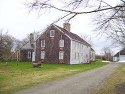
Sites of historic interest in Little Compton include the Wilbor House, built in 1692 by Samuel Wilbore and now the home of the Little Compton Historical Society.[3] The entire town commons is also on the National Register of Historic Places. There are about 57 historic cemeteries in the town. Benjamin Church and his family are buried in the Little Compton Commons cemetery, as is Elizabeth Pabodie, the eldest daughter of John Alden and Priscilla Mullins of Mayflower fame. The stones in the cemetery reflect a style of carving similar to that found both in Newport and in Boston during the same time period.
Little Compton is the location for one of three town commons in Rhode Island. The others are in Warren and Bristol. This is most likely a result of the town having been originally laid out by settlers from the Plymouth and Massachusetts Colonies. Land for the common was designated in August 1677 and has been used ever since as both a religious and civic center for social activities in the town, as well as private events such as weddings and funerals. The commons contain a large cemetery.[4]
Another distinctive feature of the town is the circa 1905 "Spite Tower" found in the village of Adamsville. Built as a water tower, local lore claims that it was constructed to obscure the line of sight of a town local.
Fort Church was built near Sakonnet Point during World War II and was named for Benjamin Church. The largest of the four batteries was Battery Gray with two 16-inch guns, an area that became the Sakonnet Golf Club.[5]
Demographics

| Historical population | |||
|---|---|---|---|
| Census | Pop. | %± | |
| 1790 | 1,542 | — | |
| 1800 | 1,577 | 2.3% | |
| 1810 | 1,553 | −1.5% | |
| 1820 | 1,580 | 1.7% | |
| 1830 | 1,378 | −12.8% | |
| 1840 | 1,327 | −3.7% | |
| 1850 | 1,462 | 10.2% | |
| 1860 | 1,304 | −10.8% | |
| 1870 | 1,166 | −10.6% | |
| 1880 | 1,202 | 3.1% | |
| 1890 | 1,128 | −6.2% | |
| 1900 | 1,132 | 0.4% | |
| 1910 | 1,273 | 12.5% | |
| 1920 | 1,389 | 9.1% | |
| 1930 | 1,382 | −0.5% | |
| 1940 | 1,492 | 8.0% | |
| 1950 | 1,556 | 4.3% | |
| 1960 | 1,702 | 9.4% | |
| 1970 | 2,385 | 40.1% | |
| 1980 | 3,085 | 29.4% | |
| 1990 | 3,339 | 8.2% | |
| 2000 | 3,593 | 7.6% | |
| 2010 | 3,492 | −2.8% | |
| Est. 2015 | 3,505 | [6] | 0.4% |
| U.S. Decennial Census[7][8] | |||
As of the census[1] of 2000, there were 3,593 people, 1,475 households, and 1,041 families residing in the town. The population density was 172.1 people per square mile (66.5/km2). There were 2,103 housing units at an average density of 100.7 per square mile (38.9/km2). The racial makeup of the town was 98.75% White, 0.06% African American, 0.19% Native American, 0.22% Asian, 0.08% Pacific Islander, 0.06% from other races, and 0.64% from two or more races. Hispanic or Latino of any race was 0.86% of the population.
There were 1,475 households out of which 27.7% had children under the age of 18 living with them, 60.7% were married couples living together, 6.8% had a female householder with no husband present, and 29.4% were non-families. 24.5% of all households were made up of individuals and 11.7% had someone living alone who was 65 years of age or older. The average household size was 2.44 and the average family size was 2.92.
In the town, the population was spread out with 21.7% under the age of 18, 5.1% from 18 to 24, 25.7% from 25 to 44, 29.8% from 45 to 64, and 17.7% who were 65 years of age or older. The median age was 44 years. For every 100 females, there were 97.3 males. For every 100 females age 18 and over, there were 93.1 males.
The median income for a household in the town was $75,368, and the median income for a family was $102,750. Males had a median income of $63,199 versus a median income of $38,676 for females. The per capita income for the town was $52,513. About 3.7% of families and 3.4% of the population were below the poverty line, including 1.0% of those under the age of 18 and 2.4% of those 65 and older.
Geography
According to the United States Census Bureau, the town has a total area of 28.9 square miles (75 km2), of which, 20.9 square miles (54 km2) is land and 8.0 square miles (21 km2) (27.79%) is water. One of the largest bodies of water in Little Compton is Quicksand Pond. [9] A part of Little Compton is Sakonnet Point, which is the town's southernmost point. Sakonnet Point Has views of multiple rocky islands off of the coast of Rhode Island, as well as the Sakonnet Lighthouse.
Education
There is only one school in Little Compton, the Wilbur and McMahon school. It was originally known as the Josephine Wilbur (or central) school. It had 12 classrooms and housed the town's K-12 facilities. It was renamed after additions were built in the mid 1900s. Approximately 350 students attend classes in Kindergarten through 8th grade. Located in the center of town, the residents simply refer to it as "Wilbur School." High school students usually attend Portsmouth High School in Portsmouth, RI.[10]
Rhode Island Red
The Rhode Island Red is a breed of chicken originally bred in Adamsville, a small village that is part of Little Compton. Little Compton is the only place in the United States with a monument dedicated to a chicken. In 1925, the Rhode Island Red Club of America donated funds for an elegant monument to the Rhode Island Red in Adamsville, near the baseball field and across the street from the Barn restaurant. The monument is now on the National Register of Historic Places. A competing monument to the Rhode Island Red was erected by the state in 1954, 1-mile (1.6 km) south of Adamsville. Some claim that it was not created for the poultry fanciers, but for the farmers who raised them commercially in great numbers in Little Compton.
Notable people
- Awashonks (c. 1620 – c. 1684), female sachem (chief) of the Sakonnet tribe; lived in what is now Little Compton[11]
- Jack Brennan (b August 16, 1937), president Richard Nixon's post-resignation chief of staff; has a summer home in Little Compton
- Sydney Richmond Burleigh (1853–1931), painter and illustrator; building and furniture designer; born in Little Compton
- J. C. Chandor (born 1974), writer, director, and Academy Award nominee for the screenplay of Margin Call; summer resident of Little Compton[12]
- Colonel Benjamin Church (c. 1639 – 1718), founder of Little Compton. Known as the father of the United States Army Rangers and commander of Colonial forces during King Philip's War (1675–76); died and is buried in Little Compton
- Christopher R. Hill (born 1952), former Assistant Secretary of State for East Asian and Pacific Affairs and former United States Ambassador to Iraq; lived in Little Compton
- Henry Demarest Lloyd (1847–1903), political activist and muckraking journalist; lived in Little Compton[13]
- J. William Middendorf (born 1924), United States Ambassador to the Netherlands, Permanent Representative to the Organization of American States, Secretary of the Navy, composer, and artist; lives in Little Compton[14]
- Arden Myrin (born 1973), comedian and actress (MADtv, Chelsea Lately); born in Little Compton
- Elizabeth Pabodie (1623–1717), daughter of Plymouth Colony settlers John Alden and Priscilla Mullins, recognized as the first white girl born in New England; buried in Little Compton
- Abel Head "Shanghai" Pierce (1834–1900), a Texas rancher and cattleman; known as an authority on cattle; born in Little Compton
- John Simmons (1796–1870), clothing manufacturer; founder of Simmons College; born in Little Compton
- Henry Tillinghast Sisson (1831–1910), American Civil War era colonel in the Union Army; Lieutenant Governor of Rhode Island; inventor of the three-ring binder; lived and died in Little Compton
- Paul Suttell (born 1949), current Chief Justice of the Rhode Island Supreme Court; lives in Little Compton
- Charles Edwin Wilbour (1833–1896), journalist and Egyptologist who produced the first English translation of Les Misérables; born in Little Compton
- Isaac Wilbour (1763–1837), 6th Governor of Rhode Island; US congressman; 34th Chief Justice of the Rhode Island Supreme Court; born and died in Little Compton
- Rupert von Trapp (born 1911), eldest son of the Trapp Family Singers, whose family story inspired "The Sound of Music"; lived in Little Compton[15]
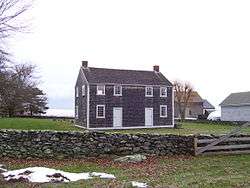
Attractions and sites on National Register of Historic Places
- Wilbor House Museum (1692)
- Friends Meeting House and Cemetery (1815)
- Little Compton Common Historic District
- Rhode Island Red Monument (1925)
- Sakonnet Light Station (1884)
- Stone House Inn (1854)
- William Whalley Homestead
- Little Compton Community Center
See also
References
- 1 2 "American FactFinder". United States Census Bureau. Retrieved 31 January 2008.
- ↑ "US Board on Geographic Names". United States Geological Survey. 2007-10-25. Retrieved 31 January 2008.
- ↑ http://www.littlecompton.org
- ↑ "Little Compton Historical Society".
- ↑ "Fort Church - FortWiki Historic U.S. and Canadian Forts". fortwiki.com. Retrieved 22 October 2015.
- ↑ "Annual Estimates of the Resident Population for Incorporated Places: April 1, 2010 to July 1, 2015". Archived from the original on June 2, 2016. Retrieved July 2, 2016.
- ↑ "Census of Population and Housing". Census.gov. Retrieved June 4, 2016.
- ↑ Snow, Edwin M. (1867). Report upon the Census of Rhode Island 1865. Providence, RI: Providence Press Company.
- ↑ "Sakonnet Point- Little Compton". Trails and Walks in Rhode Island.
- ↑ "Our School". web.archive.org. Archived from the original on 21 August 2006. Retrieved 18 October 2015.
- ↑ Wilbour, Benjamin Franklin (1967). Little Compton Families. Little Compton, RI: Little Compton Historical Society. p. xvii. ISBN 0-8063-4704-X.
- ↑ Schanen, Eric (October 2013). "Inside 'All is Lost' From a Trio of Cal 39s to Teaching Redford to Sail". Sailing Magazine. Retrieved 6 November 2013.
- ↑ Goodrich, David L. (2001). The Real Nick and Nora: Frances Goodrich and Albert Hackett, Writers of Stage and Screen Classics. Carbondale, IL: SIU Press. p. 8. ISBN 9780809389698.
- ↑ McGaw, Jim (July 16, 2012). "Little Compton Man's an Ambassador for the Arts". EastBayRI. Retrieved 6 November 2013.
- ↑ Burdett, Bruce (April 16, 2013). "Henriette von Trapp, 85, Adamsville". EastBayRI. Retrieved 6 November 2013.
External links
| Wikimedia Commons has media related to Little Compton, Rhode Island. |
| Wikivoyage has a travel guide for Little Compton. |
Municipalities and communities of Newport County, Rhode Island, United States | ||
|---|---|---|
| City | 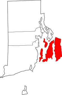 | |
| Towns | ||
| CDPs | ||
| Other villages | ||
| Islands |  | |
|---|---|---|
| Major rivers | ||
| Cities & towns | ||
| Bridges | ||
Providence (capital) | |
| Topics |
|
| Society |
|
| Regions | |
| Cities | |
| Towns |
|