Harmony, Rhode Island
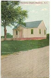
Harmony Chapel Cemetery on Route 44 around the start of the 20th century

Location of the CDP in Providence County and the state of Rhode Island.
Harmony is a village and census-designated place[1] in the town of Glocester, Rhode Island, United States located on U.S. Route 44 (Putnam Pike). As of the 2010 census, it had a population of 985.[2]
Local sites and history
The historic 1816 Harmony Chapel and Cemetery are located at the center of the village. Several restaurants, the Harmony Library and golf courses are located nearby. In the early nineteenth century a toll booth of the Glocester Turnpike was located in Harmony to raise funds to maintain the road until it was abolished in the 1850s.[3]
Images
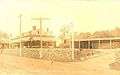 Yan-Yan-Ke Club in Harmony at the start of the 20th Century
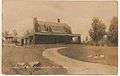 Warren Estate on Sawmill Road in Harmony
 Sen. Arthur Steere's birthplace on the corner of Snake Hill & Sawmill Roads
 Laurel Grange on Snake Hill & Sawmill Road
References
- ↑ U.S. Geological Survey Geographic Names Information System: Harmony, Rhode Island
- ↑ "Profile of General Population and Housing Characteristics: 2010 Demographic Profile Data (DP-1): Harmony CDP, Rhode Island". U.S. Census Bureau, American Factfinder. Retrieved October 15, 2012.
- ↑ Elizabeth A. Perry, A brief history of the town of Glocester, Rhode Island (Providence Press Co., Printers, 1886)
External links
Municipalities and communities of Providence County, Rhode Island, United States | ||
|---|---|---|
| Cities |  | |
| Towns | ||
| CDPs | ||
| Other villages | ||
Coordinates: 41°53′16″N 71°35′48″W / 41.88778°N 71.59667°W
This article is issued from
Wikipedia.
The text is licensed under Creative Commons - Attribution - Sharealike.
Additional terms may apply for the media files.