Leon County, Florida
| Leon County, Florida | |||
|---|---|---|---|
.JPG) Leon County Courthouse | |||
| |||
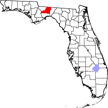 Location in the U.S. state of Florida | |||
 Florida's location in the U.S. | |||
| Founded | December 29, 1824 | ||
| Named for | Juan Ponce de León | ||
| Seat | Tallahassee | ||
| Largest city | Tallahassee | ||
| Area | |||
| • Total | 702 sq mi (1,818 km2) | ||
| • Land | 667 sq mi (1,728 km2) | ||
| • Water | 35 sq mi (91 km2), 5.0% | ||
| Population (est.) | |||
| • (2017) | 290,292[1] | ||
| • Density | 435/sq mi (168/km2) | ||
| Congressional districts | 2nd, 5th | ||
| Time zone | Eastern: UTC−5/−4 | ||
| Website |
www | ||


Leon County is a county located in the U.S. state of Florida. As of 2017 Census estimates, the population was 290,292.[2] The county seat is Tallahassee,[3] which also serves as the state capital. The county is named after the Spanish explorer Juan Ponce de León.
Leon County is included in the Tallahassee metropolitan area. Tallahassee is home to two of Florida's major public universities, Florida State University and Florida A&M University.
History
Originally part of Escambia and later Gadsden County, Leon County was created in 1824.[4] It was named after Juan Ponce de León, the Spanish explorer who was the first European to reach Florida.[5] During the 1850s and 1860s, Leon County was a "cotton kingdom" and ranked fifth of all Florida and Georgia counties in the production of cotton from the 20 major plantations. Unique among Confederate capitals east of the Mississippi River in the American Civil War, Tallahassee was never captured by Union forces, and no Union soldiers set foot in Leon County until Reconstruction.
Geography
According to the U.S. Census Bureau, the county has a total area of 702 square miles (1,820 km2), of which 667 square miles (1,730 km2) are land and 35 square miles (91 km2) (5.0%) are water.[6] Unlike much of Florida, most of Leon County has rolling hills, part of north Florida's Red Hills Region. The highest point is 280 feet (85 m), located in the northern part of the county.
National protected area
- Apalachicola National Forest (part)
Bodies of water
- Lake Miccosukee
- Black Creek
- Lake Bradford
- Lake Ella
- Lake Hall
- Lake Iamonia
- Lake Jackson
- Lake Lafayette
- Lake Talquin
- Ochlockonee River
- Lake Munson
Adjacent counties
- Grady County, Georgia - north
- Thomas County, Georgia - northeast
- Jefferson County - east
- Wakulla County - south
- Gadsden County - west
- Liberty County - west
Transportation
Airports
Major highways
Geology

Leon County sits atop basement rock composed of basalts of the Triassic and Jurassic from ~251—145 million years ago interlayered with Mesozoic sedimentary rocks. The layers above the basement are carbonate rock created from dying foraminifera, bryozoa, mollusks, and corals from as early as the Paleocene, a period of ~66—55.8 Ma.[8]
During the Eocene (~55.8—33.9 Ma) and Oligocene (~33.9—23 Ma), the Appalachian Mountains began to uplift and the erosion rate increased enough to fill the Gulf Trough with quartz sands, silts, and clays via rivers and streams. The first sedimentation layer in Leon County is the Oligocene Suwannee Limestone in the southeastern part of the county as stated by the United States Geological Survey and Florida Geological Survey.[9]
The Early Miocene (~23.03—15.7 Ma) sedimentation in Leon County is Hawthorn Group, Torreya Formation and St. Marks Formation and found in the northern two-thirds of the county.
The Pliocene (~5.332—2.588 Ma) is represented by the Miccosukee Formation scattered within the Torreya Formation.
Sediments were laid down from the Pleistocene epoch (~2.588 million—12 000 years ago) through Holocene epoch (~12,000—present) and are designated Beach ridge and trail and undifferentiated sediments.
Terraces and shorelines
During the Pleistocene, what would be Leon County emerged and submerged with each glacial and interglacial period. Interglacials created the topography of Leon as it is known now.
Also See Leon County Pleistocene coastal terraces
Also see: Florida Platform and Lithostratigraphy
Geologic formations
- Red Hills Region (North)
- Cody Scarp (central)
- Woodville Karst Plain (South)
Demographics
| Historical population | |||
|---|---|---|---|
| Census | Pop. | %± | |
| 1830 | 6,494 | — | |
| 1840 | 10,713 | 65.0% | |
| 1850 | 11,442 | 6.8% | |
| 1860 | 12,343 | 7.9% | |
| 1870 | 15,236 | 23.4% | |
| 1880 | 19,662 | 29.0% | |
| 1890 | 17,752 | −9.7% | |
| 1900 | 19,887 | 12.0% | |
| 1910 | 19,427 | −2.3% | |
| 1920 | 18,059 | −7.0% | |
| 1930 | 23,476 | 30.0% | |
| 1940 | 31,646 | 34.8% | |
| 1950 | 51,590 | 63.0% | |
| 1960 | 74,225 | 43.9% | |
| 1970 | 103,047 | 38.8% | |
| 1980 | 148,655 | 44.3% | |
| 1990 | 192,493 | 29.5% | |
| 2000 | 239,452 | 24.4% | |
| 2010 | 275,487 | 15.0% | |
| Est. 2017 | 290,292 | [10] | 5.4% |
| U.S. Decennial Census[11] 1790-1960[12] 1900-1990[13] 1990-2000[14] 2010-2015[2] | |||
Race
As of the census[15] of 2010, there were 275,487 people, and 108,592 households residing in the county. The population density was 413.2 people per square mile (159.5/km²). There were 123,423 housing units at an average density of 185 per square mile (71.4/km²). The racial makeup of the county was 63.0% White, 30.3% Black or African American, 0.3% Native American, 2.9% Asian, 0.1% Pacific Islander, and 2.2% from two or more races. 5.6% of the population were Hispanic or Latino of any race.
Age
There were 108,592 households out of which 24.2% had children under the age of 18 living with them, 36.9% were married couples living together, 13.1% had a female householder with no husband present, and 45.8% were non-families. 31.0% of all households were made up of individuals and 6.1% had someone living alone who was 65 years of age or older. The average household size was 2.29 and the average family size was 2.92.
In the county, the population was spread out with 20.0% under the age of 18, 26.3% from 18 to 24, 22.7% from 25 to 44, 22.4% from 45 to 64, and 8.7% who were 65 years of age or older. The median age was 27.8 years. For every 100 females, there were 91.57 males. For every 100 females age 18 and over, there were 89.03 males.
Education
The adult citizens of Leon County enjoy the highest level of education in the state of Florida followed by Alachua County with a total of 67.8%.
| Level of Education | ||||
|---|---|---|---|---|
| Level | Leon Co. | Florida | U.S. | |
| Some college or associate degree | 28.5% | 28.8% | 27.4% | |
| Bachelor's Degree | 24.0% | 14.3% | 15.5% | |
| Master's or Ph. D. | 17.7% | 8.1% | 8.9% | |
| Total | 70.2% | 51.2% | 51.8% | |
Source of above:[16]
Income
The median income for a household in the county was $37,517, and the median income for a family was $52,962. Males had a median income of $35,235 versus $28,110 for females. The per capita income for the county was $21,024. About 9.40% of families and 18.20% of the population were below the poverty line, including 16.20% of those under age 18 and 8.20% of those age 65 or over.
Accolades
- 2007 National Association of County Park and Recreation Officials' Environmental and Conservation Award for exceptional effort to reclaim, restore, preserve, acquire or develop unique and natural areas. Leon County has 1,300 acres (5.3 km2) of open space, forest and woodlands between the Miccosukee Canopy Road Greenway and J.R. Alford Greenway.
Politics
Voting trends
Leon County is a traditional blue county and has usually voted Democratic. This is likely due to Florida State University and Florida A&M University in Tallahassee, as well as the concentration of government employees in the capital city.
- On December 31, 2007 there were 85,546 Democrats and 42,744 Republicans. Other affiliations accounted for 22,284 voters.
- On March 1, 2009 there were 103,334 Democrats and 48,507 Republicans. Other affiliations accounted for 28,191 voters.[17]
- As of November 2, 2017 there were 108,281 Democrats and 57,132 Republicans. Other affiliations accounted for 40,375 voters, for a total registered voter population of 205,788.[18]
| Year | Republican | Democratic | Other |
|---|---|---|---|
| 2016 | 34.98% 53,821 | 59.83% 92,068 | 5.19% 7,992 |
| 2012 | 37.54% 55,805 | 61.13% 90,881 | 1.34% 1,985 |
| 2008 | 37.40% 55,705 | 61.60% 91,747 | 1.00% 1,483 |
| 2004 | 37.85% 51,615 | 61.50% 83,873 | 0.65% 891 |
| 2000 | 37.88% 39,073 | 59.57% 61,444 | 2.55% 2,637 |
| 1996 | 36.99% 33,930 | 54.59% 50,072 | 8.42% 7,715 |
| 1992 | 32.87% 31,983 | 49.12% 47,791 | 18.01% 17,520 |
| 1988 | 51.39% 36,055 | 47.71% 33,472 | 0.90% 631 |
| 1984 | 55.00% 36,325 | 44.94% 29,683 | 0.06% 38 |
| 1980 | 43.47% 24,919 | 49.63% 28,450 | 6.90% 3,957 |
| 1976 | 44.42% 23,739 | 53.76% 28,729 | 1.82% 975 |
| 1972 | 63.72% 27,479 | 36.07% 15,555 | 0.21% 92 |
| 1968 | 28.49% 9,288 | 32.02% 10,440 | 39.50% 12,878 |
| 1964 | 58.15% 15,181 | 41.85% 10,927 | |
| 1960 | 46.53% 9,079 | 53.47% 10,433 | |
| 1956 | 49.30% 6,828 | 50.70% 7,022 | |
| 1952 | 41.19% 5,604 | 58.81% 8,000 | |
| 1948 | 18.65% 1,149 | 58.55% 3,607 | 22.80% 1,405 |
| 1944 | 15.64% 835 | 84.36% 4,505 | |
| 1940 | 9.65% 583 | 90.35% 5,459 | |
| 1936 | 6.84% 277 | 93.16% 3,770 | |
| 1932 | 7.87% 252 | 92.13% 2,950 | |
| 1928 | 24.72% 630 | 74.07% 1,888 | 1.22% 31 |
| 1924 | 8.29% 92 | 85.32% 947 | 6.39% 71 |
| 1920 | 22.97% 452 | 71.75% 1,412 | 5.28% 104 |
| 1916 | 16.32% 191 | 74.79% 875 | 8.89% 104 |
| 1912 | 8.41% 56 | 81.98% 546 | 9.61% 64 |
| 1908 | 14.93% 143 | 72.86% 698 | 12.21% 117 |
| 1904 | 11.37% 84 | 87.82% 649 | 0.81% 6 |
Voter turnout
Leon County has had the highest voter turnout of all counties in Florida. For the 2008 general election, Leon County had a record setting early voting and vote by mail with a voter turnout of 85%.[20]
County representation
| Leon County Government | |||
|---|---|---|---|
| Position | Name | Party | |
| Commissioner | Nick Maddox | Democratic | |
| Commissioner | Jimbo Jackson | Democratic | |
| Commissioner | John Dailey | Democratic | |
| Commissioner | Kristen Dozier | Democratic | |
| Commissioner | Bill Proctor | Democratic | |
| Commissioner | Bryan Desloge | Republican | |
| Commissioner | Mary Ann Lindley | Democratic | |
| Elections Supervisor | Mark Earley | NPA | |
| Tax Collector | Doris Maloy | Democratic | |
| Property Appraiser | Akin Akinyemi | Democratic | |
| Court Clerk | Gwen Marshall | Democratic | |
| Sheriff | Walt McNeil | Democratic | |
| School Superintendent | Rocky Hanna | NPA | |
| Soil and Water Supervisor 1 | Blas Gomez | Non Partisan | |
Consolidation with Tallahassee
Voters of Leon County have gone to the polls four times to vote on consolidation of Tallahassee and Leon County governments into one jurisdiction[21] combining police and other city services with already shared (consolidated) Tallahassee Fire Department, Tallahassee/Leon County Planning Department, and Leon County Emergency Medical Services. Tallahassee's city limits would (at current size) increase from 98.2 square miles (254 km2) to 702 square miles (1,820 km2). Roughly 36 percent of Leon County's 250,000 residents live outside the Tallahassee city limits.
| Leon County Voting On Consolidation | |||||||
|---|---|---|---|---|---|---|---|
| Year | FOR | AGAINST | |||||
| 1971 | 10,381 (41.32%) | 14,740 (58.68%) | |||||
| 1973 | 11,056 (46.23%) | 12,859 (53.77%) | |||||
| 1976 | 20,336 (45.01%) | 24,855 (54.99%) | |||||
| 1992 | 37,062 (39.8%) | 56,070 (60.2%) | |||||
The proponents of consolidation have stated that the new jurisdiction would attract business by its very size. Merging of governments would cut government waste, duplication of services, etc. However Professor Richard Feiock states that no discernible relationship exists between consolidation and the local economy.[22]
U.S. Congressional representatives
Leon County is split into two congressional districts along racial lines. The northern and eastern portion of Leon County, including 61% of Tallahassee, is located in the 5th Congressional District, a black minority majority district, which is currently represented by Al Lawson (D). The remainder of the county (the southeastern corner and 39% of Tallahassee),is in the 2nd Congressional District currently represented by Neal Dunn (R).
State Representatives
Rep. Loranne Ausley (D), District 9, represents the northern half of Leon County including most of Tallahassee. Rep. Halsey Beshears (R), District 7, represents the southern portion of the county. Rep. Ramon Alexander (D), District 8, also represents a west-central portion of the county.
State Senator
All of Leon County is represented by Bill Montford (D) District 3 in the Florida Senate.
Public safety
Leon County Sheriff
The Leon County Sheriff's Office provides police patrol, detective service, court protection, coroner service, and county prison operation for the unincorporated part of Leon County. Fire and Emergency medical services are provided by the Tallahassee Fire Department and Leon County Emergency Medical Services respectively.
Tallahassee Police Department
Tallahassee is the only incorporated municipality within Leon County. Its policing is provided by the Tallahassee Police Department. Established 1826, TPD is recognized as being the third longest accredited law enforcement agency in the country.[23]
Education
Public schools in Leon County are administered and under the operation of the Leon County School District. LCS is operated by a superintendent, 5 board members, and 1 Student Representative. There are:
- 25 Elementary Schools
- 10 Middle Schools
- 7 High Schools
- 8 Special / Alternative Schools
- 2 Charter Schools
High schools
- Amos P. Godby High School - website
- Atlantis Academy
- Florida Agricultural & Mechanical University High School
- Florida State University High School
- James S. Rickards High School
- John Paul II Catholic High School - website
- Lawton Chiles High School
- Leon High School
- Lively Technical Center
- Lincoln High School
- Maclay School - website
- North Florida Christian High School - website
- SAIL High School - website
Libraries
Leon County has 7 branches that serve the area.
- Leroy Collins Main Library
- Northeast Branch Library
- Eastside Branch Library
- Dr. B.L. Perry, Jr. Branch Library
- Lake Jackson Branch Library
- Woodville Branch Library
- Jane G. Sauls Fort Braden Branch Library
The official name of the library system is the LeRoy Collins Leon County Public Libraries System. The name was changed on September 17, 1993 from the original name of the Leon County Public Library in honor of LeRoy Collins, the 33rd Governor of Florida.[24]
History of Library Services
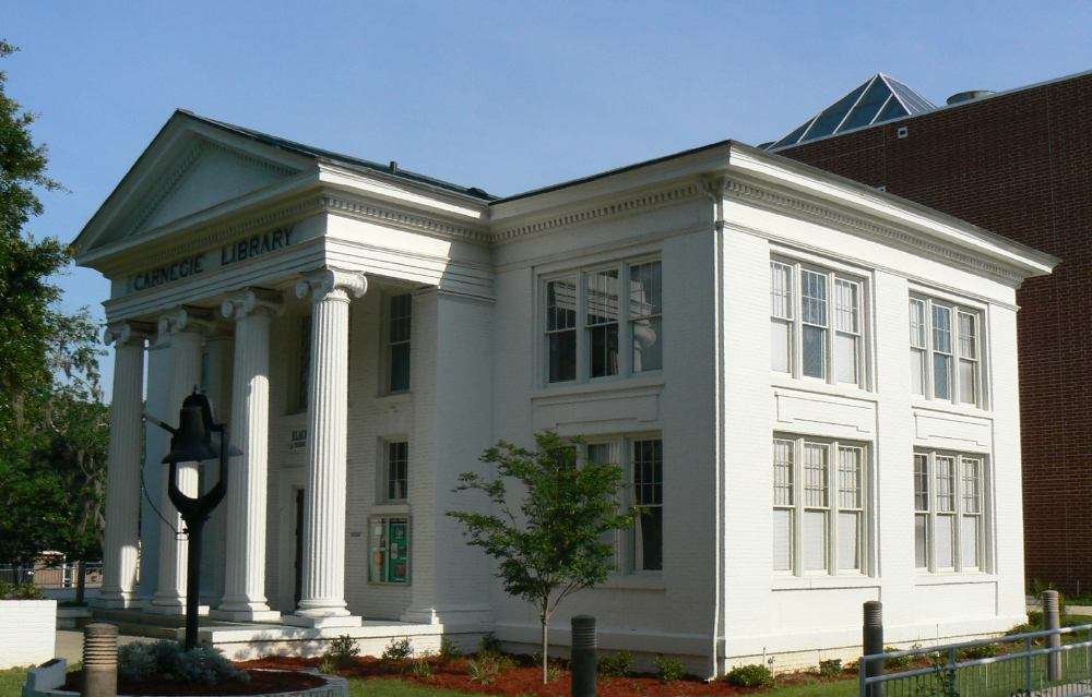
The Carnegie Library of Tallahassee provided library services to the black community prior to desegregation. This library was the first and only public library in the city of Tallahassee until 1955. The philanthropist, Andrew Carnegie offered the city of Tallahassee money to build a public library in 1906. According to an article written in Africology: The Journal of Pan African Studies, The library was built on the campus of Florida A&M University because the city refused the donation based on the fact that it would have to serve the black citizens. "The facility boasted modern amenities such as electricity, indoor plumbing and water supplied by the city. In later years, the Library served as an art gallery, religious center, and in 1976, became the founding home of the Black Archives Research Center and Museum. By functioning both as a repository for archival records and a museum for historical regalia, the center continues to render academic support to educational institutions, civic, political, religious and Museum. By functioning both as a repository for archival records and a museum for historical regalia, the center continues to render academic support to educational institutions, civic, political, religious and social groups, as well as, public and private businesses throughout Florida and the nation."[25] The building was designed by noted architect William Augustus Edwards and was built in 1908. On November 17, 1978, it was added to the U.S. National Register of Historic Places.
The Carnegie Library of Tallahassee which only served the black community became the only free public library in the city until 1955. According to the Leon County Public Library's website, the American Association of University Women formed the Friends of the Library organization in 1954. The formation of the Friends of the Library was in direct response to the fact that "Tallahassee was the only state capital in the United States not offering free public library service." [26] One year later, the library was established in May by legislative action and was developed by citizens and civic groups. In 1956 the first Leon County free public library opened on March 21. The first building used to house the library was The Columns, one of the oldest remaining antebellum homes in the Leon County area located at Park Avenue and Adams street (the building today is home of the James Madison Institute).
In order to expand library services the Junior League of Tallahassee donated a bookmobile to the library. The vehicle was later donated to the Leon County Sherriff's Office to be used as a paddy wagon for its Road Prison. In 1962 the library moved to the old Elks Club building at 127 North Monroe Street. Public transit in the city of Tallahassee was desegregated by 1958, yet it would several more years before the public library system would experience integration.
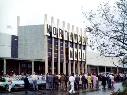
In the early 70's Jefferson and Wakulla counties joined the Leon County Public Library System, forming the Leon, Jefferson, and Wakulla County Public Library System. According to the library's web site, "Leon County provided administrative and other services to the two smaller counties, while each supported the direct costs of their library services and their share of Leon's administrative costs."[26] In 1975 the system started a branch library in the Bond community, a predominantly black community on the city's Southside. Wakulla County left the library cooperative in 1975 to start its own library system and in 1978 the main library moved to a location in Tallahassee's Northwood Mall. Jefferson County left the library cooperative in 1980 and the library reverted to the Leon County Public Library. In 1989 "ground breaking was held on March 4 for a new $8.5 million main library facility with 88,000 feet of space. The site was next door to the library's original home, The Columns, which had been moved in 1971 to 100 N. Duval."[26] The new library had its grand opening in 1991 and was renamed in 1993 in honor of former Governor LeRoy Collins.
1908 photo of the Carnegie Library Tallahassee
1957 Bookmobile donated by the Junior League of Tallahassee Old Elks Club at 127 N. Monroe. Home to the Leon County Public Library in 1962 Photo of the Northwood Centre in Tallahassee circa 1978 Photo of the current LeRoy Collins Leon County Public Library. The system's main branch.
Points of interest
- Alfred B. Maclay Gardens State Park
- Apalachicola National Forest
- Birdsong Nature Center
- Bradley's Country Store Complex
- Florida State Capitol
- Florida Supreme Court
- Florida State Archives
- Florida Vietnam War Memorial
- Lake Jackson Mounds Archaeological State Park
- Leon County Fairgrounds
- Leon County's 5 canopy roads
- Mission San Luis de Apalachee
- Museum of Florida History
- Old Fort Park
- Tall Timbers Research Station
- Tallahassee Antique Car Museum
- Tallahassee Museum
- Tallahassee-St. Marks Historic Railroad Trail State Park
Paleontology
Three sites within Leon County have yielded fossil remnants of the Miocene epoch. The article Leon County, Florida paleontological sites includes the Griscom Plantation Site, Seaboard Air Line Railroad Site, and Tallahassee Waterworks Site with fossils by genus and species.
Communities
City
Census-designated place
Other unincorporated communities
- Baum
- Black Creek
- Bloxham[27]
- Bradfordville
- Capitola
- Centerville
- Chaires
- Chaires Crossroads
- Felkel
- Fort Braden
- Gardner
- Iamonia
- Ivan
- Lafayette
- Lutterloh
- Meridian
- Miccosukee
- Ochlockonee
- Rose
- Wadesboro
Defunct entity
- Bond-South City, a former census-designated place enumerated by the United States Census Bureau in 1950 & 1960.
See also
References
- ↑ https://www.census.gov/quickfacts/fact/table/leoncountyflorida/PST045217
- 1 2 "State & County QuickFacts". United States Census Bureau. Archived from the original on July 13, 2011. Retrieved June 14, 2014.
- ↑ "Find a County". National Association of Counties. Retrieved 2011-06-07.
- ↑ Publications of the Florida Historical Society. Florida Historical Society. 1908. p. 32.
- ↑ Gannett, Henry (1905). The Origin of Certain Place Names in the United States. U.S. Government Printing Office. p. 185.
- ↑ "US Gazetteer files: 2010, 2000, and 1990". United States Census Bureau. 2011-02-12. Retrieved 2011-04-23.
- ↑ "Tallahassee's airport goes international". Tallahassee Democrat. Retrieved July 8, 2015.
- ↑ Geology of Florida, University of Florida Archived 2009-12-28 at the Wayback Machine.
- ↑ USGS Publications, Florida
- ↑ "Population and Housing Unit Estimates". Retrieved June 9, 2017.
- ↑ "U.S. Decennial Census". United States Census Bureau. Retrieved June 14, 2014.
- ↑ "Historical Census Browser". University of Virginia Library. Retrieved June 14, 2014.
- ↑ "Population of Counties by Decennial Census: 1900 to 1990". United States Census Bureau. Retrieved June 14, 2014.
- ↑ "Census 2000 PHC-T-4. Ranking Tables for Counties: 1990 and 2000" (PDF). United States Census Bureau. Retrieved June 14, 2014.
- ↑ "American FactFinder". United States Census Bureau. Retrieved 2011-05-14.
- ↑ 2000 U.S. Census at EPodunk.com - An examination of all Florida counties
- ↑ Leon County Supervisor of Elections updated registered voter counter Archived 2014-08-10 at the Wayback Machine.
- ↑ "Active Registered Voter Data". Leon County Supervisor of Elections. Retrieved November 2, 2017.
- ↑ Leip, David. "Dave Leip's Atlas of U.S. Presidential Elections". uselectionatlas.org. Retrieved 2018-06-15.
- ↑ Leon County Supervisor of Elections graphic Archived 2014-08-10 at the Wayback Machine.
- ↑ "Consolidation of City (Tallahassee) & County (Leon) Government" (PDF). Leon County Supervisor of Elections. Retrieved November 2, 2017.
- ↑ http://www.fsu.edu/~localgov/publication_files/Feiock&Park&Kang_Consolidation_K3.pdf Archived 2007-06-14 at the Wayback Machine.
- ↑ TPD web site
- ↑ "Governor Thomas LeRoy Collins". LeRoy Collins Leon County Public Library. Retrieved 27 October 2014.
- ↑ "Carrie Meek - James N. Eaton, Sr. Southeastern Regional Black Archives Research Center and Museum" (PDF). Africology: The Journal of Pan African Studies. 10 (2): 263–272. 2017.
- 1 2 3 Leon County. (2002-2016). Library History. Retrieved April 09, 2018, from Leon County Florida Government: http://cms.leoncountyfl.gov/Library/LibraryInformation/Library-History
- ↑ Bloxham, Florida. Google Maps. Retrieved 2013-09-04.
External links
| Wikimedia Commons has media related to Leon County, Florida. |
Government links/Constitutional offices
- Leon County Government / Board of County Commissioners
- Leon County Clerk of Courts
- Leon County Property Appraiser
- Leon County Sheriff's Office
- Leon County Supervisor of Elections
- Leon County Tax Collector
Special districts
Judicial branch
Tourism links
Places adjacent to Leon County, Florida | |
|---|---|

| Topics |  Map of North Florida | |
|---|---|---|
| Counties | ||
| Major cities | ||
| Cities and towns 100k+ | ||
| Cities and towns 25k–100k | ||
| Cities and towns 10k–25k | ||
| Metro areas | ||
| Regions | ||