Stjørdalselva
| Stjørdalselva | |
|---|---|
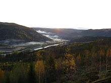
.jpg) View of the river at Hegra | |
 Location of the river  Stjørdalselva (Norway) | |
| Country | Norway |
| County | Trøndelag |
| Municipality | Meråker and Stjørdal |
| Physical characteristics | |
| Main source |
Confluence of the rivers Dalåa and Torsbjørka Meråker, Trøndelag, Norway 120 metres (390 ft) 63°24′24″N 11°44′38″E / 63.40667°N 11.74389°E |
| River mouth |
Trondheimsfjord Stjørdal, Trøndelag, Norway 0 metres (0 ft) 63°26′50″N 10°54′24″E / 63.44722°N 10.90667°ECoordinates: 63°26′50″N 10°54′24″E / 63.44722°N 10.90667°E |
| Length | 70 km (43 mi) |
| Basin features | |
| Basin size | 2,111 km2 (815 sq mi) |
| Tributaries |
|
Stjørdalselva (English: Stjørdal River) is a 70-kilometre (43 mi) long river that reaches from near the Norwegian–Swedish border down the Stjørdalen valley through the municipalities of Meråker and Stjørdal before entering the Trondheimsfjord. The mouth is located between the villages of Stjørdalshalsen and Hell just south of Trondheim Airport, Værnes. The mouth of the river was moved to allow the runway to expand into the delta.[1]
Stjørdalen valley with Stjørdalselva
The European route E14 highway and the Meråker Line railway follow the river from its source the entire length of the river.
References
- ↑ Askeim, Svein, ed. (2017-12-19). "Stjørdalselva". Store norske leksikon (in Norwegian). Kunnskapsforlaget. Retrieved 2018-03-10.
This article is issued from
Wikipedia.
The text is licensed under Creative Commons - Attribution - Sharealike.
Additional terms may apply for the media files.