Ler, Norway
| Ler | |
|---|---|
| Village | |
 Ler Location of the village  Ler Ler (Norway) | |
| Coordinates: 63°11′51″N 10°18′07″E / 63.1976°N 10.3020°ECoordinates: 63°11′51″N 10°18′07″E / 63.1976°N 10.3020°E | |
| Country | Norway |
| Region | Central Norway |
| County | Trøndelag |
| District | Gauldalen |
| Municipality | Melhus |
| Area[1] | |
| • Total | 0.46 km2 (0.18 sq mi) |
| Elevation[2] | 23 m (75 ft) |
| Population (2017)[1] | |
| • Total | 589 |
| • Density | 1,280/km2 (3,300/sq mi) |
| Time zone | UTC+01:00 (CET) |
| • Summer (DST) | UTC+02:00 (CEST) |
| Post Code | 7234 Ler |
Ler is a village in the municipality of Melhus in Trøndelag county, Norway. It is located along the Gaula River between the villages of Kvål and Lundamo. The 0.46-square-kilometre (110-acre) village has a population (2017) of 589 which gives the village a population density of 1,280 inhabitants per square kilometre (3,300/sq mi).[1]
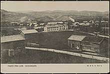
View of Ler in 1906
Ler Station is located in the village along the Dovre Line, and it is served by commuter trains on Trønderbanen. The European route E6 highway also runs through the village.[3] The most famous citizen of the village is former prime minister Per Borten. Ler was the administrative center of the former municipality of Flå. It is also the location of Flå Church.
References
- 1 2 3 Statistisk sentralbyrå (1 January 2017). "Urban settlements. Population and area, by municipality".
- ↑ "Ler, Melhus (Trøndelag)". yr.no. Retrieved 2018-01-28.
- ↑ Store norske leksikon. "Ler" (in Norwegian). Retrieved 2011-03-18.
This article is issued from
Wikipedia.
The text is licensed under Creative Commons - Attribution - Sharealike.
Additional terms may apply for the media files.