Klæbu (village)
| Klæbu | |
|---|---|
| Village | |
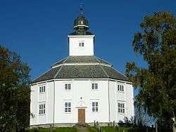 View of the local church | |
 Klæbu Location of the village  Klæbu Klæbu (Norway) | |
| Coordinates: 63°17′51″N 10°28′57″E / 63.2976°N 10.4826°ECoordinates: 63°17′51″N 10°28′57″E / 63.2976°N 10.4826°E | |
| Country | Norway |
| Region | Central Norway |
| County | Trøndelag |
| District | Trondheim Region |
| Municipality | Klæbu |
| Area[1] | |
| • Total | 1.59 km2 (0.61 sq mi) |
| Elevation[2] | 140 m (460 ft) |
| Population (2017)[1] | |
| • Total | 3,319 |
| • Density | 2,087/km2 (5,410/sq mi) |
| Time zone | UTC+01:00 (CET) |
| • Summer (DST) | UTC+02:00 (CEST) |
| Post Code | 7540 Klæbu |
Klæbu is the administrative centre of Klæbu municipality in Trøndelag county, Norway. The village is located on the eastern shore of the river Nidelva, about 2 kilometres (1.2 mi) east of the village of Tanem and about 15 kilometres (9.3 mi) south of the city of Trondheim.[3] The village sits at the junction of Norwegian county roads 805 and 921. The historic Klæbu Church is located in the village.
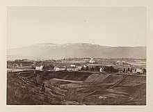
View of Klæbu in the late 19th century.
The 1.59-square-kilometre (390-acre) village has a population (2017) of 3,319 which gives the village a population density of 2,087 inhabitants per square kilometre (5,410/sq mi).[1]
The newspaper KlæbuPosten is published in Klæbu.[4]
References
- 1 2 3 Statistisk sentralbyrå (1 January 2017). "Urban settlements. Population and area, by municipality".
- ↑ "Klæbu (Trøndelag)". yr.no. Retrieved 2018-03-12.
- ↑ Olsen Haugen, Morten, ed. (2017-09-10). "Klæbu – tettsted". Store norske leksikon (in Norwegian). Kunnskapsforlaget. Retrieved 2018-03-13.
- ↑ "KlæbuPosten" (in Norwegian). Kommunenvår.no.
This article is issued from
Wikipedia.
The text is licensed under Creative Commons - Attribution - Sharealike.
Additional terms may apply for the media files.